|
Mason - Dixon Trail/Otter Creek Loop
|
|
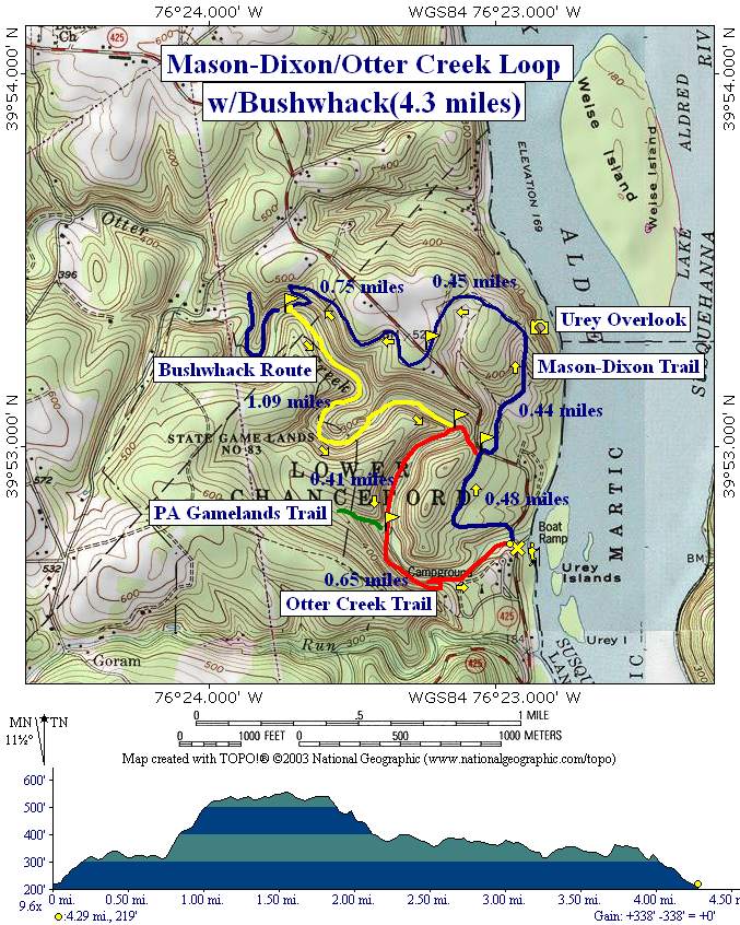
Description: I always thought this was a 6 mile hike. My software tells me it is only a little over 4 miles. It must seem longer because of the bushwhack! I still recommend it because of the view at the overlook and the solitude found along Otter Creek. The Holtwood Recreation area has such beautiful streams.
Warning: This hike includes a 1.1 mile bushwhack along a section of Otter Creek and one wide stream crossing. Originally this was mostly considered an �open Woods� bushwhack but the presence of recent large blow-downs will require a bit more work for this one segment!!!
|
|
|
Trail Notes: From the parking lot, Cross the bridge over otter Creek and immediately proceed up the blue blazed Mason Dixon Trail. At the top of the hill come to an intersection. Turn right to stay on the Mason-Dixon Trail. Pass through some tall evergreens and in 0.48 miles cross RT 425. The continuation of the trail is a few yards downhill behind a forest gate.
Follow this old forest road until you reach a small stream. The woods road goes straight and eventually will reconnect with the trail. At this point you want to turn right and follow the blazes along and across the stream. Climb steeply to Urey Overlook (0.44 miles from the last RT 425 crossing).
From here follow the trail until it reconnects with the woods road. Follow it out to RT 425 again and cross the road for the final time. Continue to follow the Mason-Dixon Trail around private property until it descends quickly through a series of switchbacks to Otter Creek (0.75 miles from the last road crossing).
This is where the bushwhack begins. Because of high valley walls and rocky ledges you have to cross here or a little further upstream. After crossing turn downstream, staying as close to the creek as possible. At times you will have to climb over or scoot under blow-downs and at other times it will be better if you climb up the hill just a bit and go around them. Just keep the creek in your sight. In a couple of places you might come close to walking in the creek but there is a narrow tread across rocks that will preclude this. At about 0.4 miles from the crossing you will notice that the creek and valley make a sharp right turn. At this point it is not necessary to follow the stream. Cut across the point of land and regain the creek on the other side. In about another 1/3 of a mile you will find yourself on a pretty decent footpath. I think this is an unofficial extension of the Otter Creek Trail.
Soon arrive at another sharp right turn in the creek. Here you should start to see sporadic red blazes. |
|
At
about 0.4 miles from this point the trail goes up a small stream a
few yards, crosses it and follows Otter creek from a slightly
higher elevation. A green blazed Gamelands trail follows
the side stream. Continue following the creek and red blazes. As you
reach the campground look for a series of sharp switchbacks on the
left that takes you back down to the creek and then out to your
cars. If you miss this turn-off just walk through the campground,
stop at the camp store, buy some ice cream and follow the blue
blazed Mason-Dixon Trail (to the left of the store) back to your
car. Printable/Downloadable Directions and Trail Notes ________________________________________
Name: Ed Lyman
Hike: MD-Otter Creek w/ bushwhack ________________________________________
Name: Michele
Hike: Otter Creek/Mason Dixion ________________________________________
Name: Wayne Reno
Hike: Mason - Dixon Trail/Otter Creek Loop
M.R.Hyker's note: You need to ford the stream and bushwhack down the south-west bank. ________________________________________
Name: Pete Hike: Otter Creek-Mason-Dixon Trail Date: 09/23/07 Rating: 3.75
Critique: Having lost a day on a backpacking trip that ended for me too soon, I went down to Otter Creek to see one of PA�s most beautiful streams, since I hadn�t been to Otter Creek before.
As in the other critique, the parking lot was gated shut so I parked at the campground with their permission. A couple of local bicyclists passing by as I pondered the map by the gate, said it�s gated shut nearly all the time now.
Hiking during leaf-on sees many of the trail markings obscured by branches, even on the Mason-Dixon Trail but especially on the others. Urey Overlook is nearly totally obscured by saplings. It�s a winter overlook now until someone gets there with a chain saw.
The lower trail at the end is signed �no trespassing� at the campground stairs and �no trespassing� with orange snow fence at the end facing the former parking lot. That�s too bad since I unknowingly hiked it from the other end (marked with a high concentration of �no swimming and diving, hidden rocks� signs on the upper trail) and passed a couple of nice small falls and through a curious rock cut.
Maybe when the electricity rate cap ends in PA then PPL will feel rich enough to improve the trails here as they have at some of their other sites across the river.
Speaking of the other side of the river, on another occasion I lengthened a Kelly�s Run/Pinnacle hike by walking over to and around the ghost town of Holtwood since I could see it on the quad. It�s visible just on the bottom of the map for #96. You can see foundations, front steps, etc. by following the curb lines of the old streets through the overgrowth. It wasn�t posted against trespassing when I was there (might be two years ago now). Just follow the road over from the switchback in the �Kelly�s Run Return Trail� down across Holtwood Rd and climb up the other side.
I wondered why someone felt compelled to demolish the homes until I realized there are no cuts in the curbs for driveways. Maybe a pedestrian village would have survived down DC way, but not in southern Lancaster County after the dam workers moved away. (BTW, Safe Harbor dam has a similar patch village initially built for dam workers, but since that dam wasn�t built until 1930 they added garages there.)
Thanks as always for the good stuff on your site. ________________________________________
Name: Local
Hike:
Otter Creek-Mason-Dixon Trail
________________________________________ |
|
|