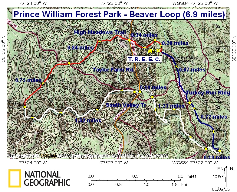
Beaver loop

Description: This is an easy 6.9 mile circuit in Prince William Forest Park between Dumfries and Fredericksburg, VA right off of I-95. The trails are well-marked and meticulously groomed. There are some hills but they are usually either long and slight or steep but very short. For that reason I show no Elevation profiles for this park.


Although I prefer to hike in Prince William in the winter it should be given serious consideration for spring and fall outings, especially for beginners. In the spring the under-story along the creeks are abloom with Red Bud, Dogwood and Wild Azaleas. In the fall there is always the orange and yellows of Maple, Beech and other deciduous trees.


Google Custom Directions


After you enter the park turn left onto the Scenic Drive and follow the signs to the Turkey Run Education Center (T.R.E.E.C.). There are bathrooms behind the building.

____________________________________

Printable/Downloadable Map!

Printable/Downloadable Map!

View 3-D Map!

Zipped National Geographic. TOPO! GPS and Universal GPX Files

GPS Text File For Non-TOPO! Users

Trail Notes: From the parking lot turn left onto Black Top Rd. Pass some out buildings on the right and then red blazed Mary Bird Branch Trail, also on the right. In 0.2 miles from the parking lot turn left onto orange blazed High Meadows Trail.


In another 0.34 miles arrive at blue blazed Taylor Farm Road. High Meadows Trail should continue exactly on the other side of the road. (If there is no trail there you probably got on “old” High Meadow Trail which brings you out just below this intersection. (It’s easy to do in the winter. Simply turn right and walk a short distance to the obvious trail junction.)


Continue on High Meadows Trail, passing a cemetery on the left, and in 0.84 miles cross Scenic Drive.


In another 0.75 miles descend to white blazed South Valley Trail.


Turn left onto South valley Trail. You will either cross or go under the Scenic Drive 3 times: at 1.62 miles from the last trail junction, at another 0.3 miles (You’ll pass the junction of blue blazed Taylor Farm Rd that you crossed earlier on the left.) and then at another 1.23 miles. There are excellent places for a break/lunch all along the creek.


Soon after the last Scenic Drive intersection turn left onto blue blazed Turkey Run Ridge Trail.In 0.72 miles cross the Scenic Drive again and in another 0.67 miles join the Turkey Run Environmental Education Center Drive. Bear right and return to your car..

Printable/Downloadable Directions and Trail Notes!

Critique This Outing

________________________________________

________________________________________

VA Hikes MD Hikes WV Hikes PA Hikes Contact Us Home