|
All Outing Critiques
Name: Steve E.
Hike:
Roaring Creek Tract
Date: 09/13/14
Rating: 2.5
Critique: I
did not heed the advice of an earlier reviewer and failed to
call ahead to check the camping status. I arrived in the morning
to discover the area is currently closed to camping. I had
intending to stay one night, however decided to hike the loop in
one day and substituted the Roaring Creek Trail for the South
Branch Trail. Blazes are not the most obvious on Big Mountain
Trail and there are numerous other paths leading in other
directions. I went on a rainy day with low visibility and had a
difficult time keeping the trail. There are some nice views of
the reservoir, but make sure to call ahead!

Name: k8tlevy
Hike:
Old Loggers Path
Date(s):
08/30-31/14
Rating: 4
Critique: We
did this as a two day fast and light backpacking trip over Labor
Day Weekend - loved it, even though it rained like crazy one of
the days! Didn't see the road to Masten was out until we tried
to drive in on it Friday night. Luckily, the detour was easy to
follow.
We went counter-clockwise, tackling 17 miles on the first day
and the rest the second day. The trail was super easy to follow;
the orange blazes were impossible to miss, as were the arrows
when the trail turned. So many snakes, though! We saw four
rattlers on rock outcroppings. Definitely keep your eyes open.
Pleasant Stream campsites were amazing! Saw two other parties
camping there, but sites are far enough apart that it felt
private.
No views at the vistas on the second day because of the
clouds/rain; guess I'll have to come back! Trail was wet,
definitely recommend waterproof shoes/boots. Also, watch for
salamanders!
Full trip report available at
http://www.adventure-inspired.com/2014/09/old-loggers-path-backpacking-trip-report.html.
Name: Wooly Bully, Shortstack, Christopher Robins
Hike:
Otter Creek Backpack (modified)
Date(s): 08/16-18/14
Rating: 4
Critique: Having a base camp in mind we changed this hike to proceed
directly to the waterfall area. We originally planned to camp at the
Otter Creek / Moore Run / Possession Camp Trail junction, but ended up
proceeding further north to find an open site. Busy day, lots of
campers. But easy to why so many come here, the falls and deep pools of
Otter Creek make for great swimming in about as scenic a place as can
be. At this point we decided to ditch the base camp and proceed with a
regular backpack. We stopped at a really nice site, where Moore Run
joins Otter Creek. We spend most of our time hanging out on the large
flat rock, real nice views upstream, downstream, and to the side with
Moore run flowing toward us. Pretty cool having dinner practically in
the middle of the creek! Chris made a great campfire, and we hung out
real late to
9:30 or so.
Saturday night and Sunday morning brought lots of rain. Very heavy at
times. Fortunately the rain tapered off at
7am, but
the wet conditions scuttled any plans for breakfast on the rock.
Continuing north on the Otter Creek Trail took us thru some large areas
of fallen trees, most probably from the 2012 storm. Re-routes bypassed
the harder hit areas, with the trail running farther up the slope. We
also had to navigate over and around quite a few fresh blow downs, in
wet and slippery conditions, with the trail very narrow and VERY close
to the edge, making for a much more difficult hike than on Saturday's
wide open trails. But the fantastic scenery really made up for the
extra work. Conditions improved after the ford and on to the Green
Mountain Trail. After a steep climb, we leveled out and eventually
turned on to the Possession Camp Trail. After only few blow downs on
the Green Mountain Trial, we ran into a bunch more on the Possession
Camp Trail. Nice gentle downward grade, passing a deep crevasse (must
be a better geological term) in the rocks, two creeks with pretty
waterfalls, and some really cool overhanging rocks. After reaching the
Otter Creek Trail we retraced our route and set up camp at the Mylius
Trail junction, at the nice site under the hemlocks beside Otter Creek.
Chris the "firemaker" came thru again, creating a nice blaze from
soaking wet fuel.
No rain on Sunday night, and dry on Monday Morning! We continued on the
Mylius Trail back to the car, meeting two young men employed by Trout
Unlimited for the purposes of monitoring hemlock trees (applying
insecticide if necessary) and also monitoring nest boxes for flying
squirrels. On the drive back we stopped to get pictures of Seneca
Rocks, made another stop at the USFS Potomac Ranger office to pick up a
bunch of maps as well as a lot of info from the friendly ranger, and
then for a good lunch at Family Traditions in Petersburg.
Overall the routing worked out well, with distances of 5 / 10 / 2.5. No
problems navigating, only advice to GPS users is that the Possession
Camp Trail is not on the .gpx listed for this hike. The scenery was
about as nice as it gets; Otter Creek is truly "waterfall central"! But
the blow downs and wet conditions made for tough going on day #2. Had
we encountered those conditions on day #1 we may had turned back. Also
very little wildlife, we saw just a few toads, a snake, very few birds,
and no fish. Thankfully no mosquitoes!
Name: Eric
Hike:
Pulpit Rock-Pinnacle Loop
Dates: 08/31/14
Rating: 4
Critique: Long
rocky hike with good views as the payoff. Took much longer than
anticipated due to rocky terrain. Bring plenty of water and
watch for snakes... we saw
two timber rattlers (a first for us in PA!) at the Pinnacle
and some other hikers saw copperheads at Pulpit Rock. I would
not recommend it for kids less than 8 or 9 years old unless they
are accomplished hikers.
Name: Navig8tr
Hike:
Green Ridge North Circuit
Date: 08/16/14
Rating: 3
Critique:
I took this circuit
as an overnighter to test some new gear. I started near campsite 1.
I was glad to find that the blazes were recently painted, and Pine
Lick in blue, Twin Oaks in purple, unlike the description above. I
ended up doing most of the circuit the first day, and camped in
campsite 11. I was surprised to find all the small streams dry, and
15 Mile Creek was an occasional stagnant, muddy , shallow puddle. I
took 2 liters of water and took the last gulp when I reached the
car. Overall a nice walk in the woods, but maybe better for late
spring when the water might still be flowing.
Name: Tim
Hike:
Morgan Run Loop
Date: 06/17/14
Rating: 5
Critique: What
day is it? Work it, work it...
Kudo's, hat's off, a BIG right hand salute to the unknown folks
that have been maintaining the Morgan Run Loop. Every weekend I
am seeing something new. From bridges placed over streams to cut
grass and maintained trails. If you know who these unknown folks
are please pass this along.
It has been almost a year now (4 seasons) that I have been
walking the loop on the weekends and I invite anyone to join me.
You'll be happy you did. Sometimes I do a repeat to max out my
outing. And it is interesting to do it in reverse order as well.
Visit Morgan Run and let me know. It's been a great asset to me
as I am prepping for the BIG HIKE beginning March 2015.
Name: Ed S.
Hike:
Pond Run-White Rocks
Date: 05/18/14
Rating: 4
Critique: This was a
good long hike, worthy for its good views and cascading runs. I
think the Tuscarora/Pond Run summit vista is the best vista along
the loop, though White Rocks itself also gives an expansive view of
the Shenandoah Valley, Massanuttens, and Blue Ridge. Due to recent
rain, the Pond Run section creek crossings were easy cold fords,
with other areas of the trail becoming flood channels. The long
climb up Pond Run gave me a good workout. The logging road section
of the Tuscarora was basically a stream until the Racer Camp Hollow
Trail, where the stream became a broad alluvial fan. Pink
ladyslippers were prevalent throughout the highland parts of the
hike. Waites Run was flowing very well, allowing good photographic
opportunities, and it was very good the plank crossing along the Old
Mail Trail was there, as fording there would be through thigh deep
fast flowing water.
Fast flowing stream.
Name: Ed S.
Hike: Kings Gap
Date: 06/01/14
Rating: 3.8
Critique: I made a
variant starting from the pine plantation, perhaps a mistake as that
area was rather buggy. It's a nice area, but there are plenty of better
hikes in the greater Michaux area, and thus the lower rating. Most of
the overlooks, except for at the mansion and Ridge, are all somewhat
grown over. The mountain laurel was starting to bloom, and the
ornamental Catawba Rhododendrons around the mansion were in full bloom;
as were assorted flowers in the garden. Its lily pond had plenty of
frogs plus some blooming lilies. The mansion was open, so I took a
quick trek inside. (The
photo is the fireplace mantle.) A bluegrass band was performing on
the lawn outside, mostly Stanley Brothers covers. With the exceptions
of the mansion area and the Scenic Vista Trail, few people were out on
the trails.
Name: Shortstack and
Wooly Bully Hike:
Alleghenny Front trail-West
Date: 08/02-04/14
Rating: 4
Outing Critique:
DAY 1: After
checking in at the park office, we parked at the "upper lake lot", and
proceeded north on the Shingle Mill Trail. The trail follows the Black
Moshannon Creek. Even with the dark tea-colored water this creek
provides for a great walk, with lots of twist and turns, some deep
pools, and lots of rhododendron,
Cardinal Flowers, and Joe Pye Weed
along the banks. The large flat rock at around 3 miles makes for a great
lunch spot. Farther along the trail we saw a dark, mucky spring with a
few spots of contrasting white sand jetting out from the bottom. Moving
sand this fast requires a substantial flow of water. At the end of the
Shingle Mill Trail the AFT heads west, thru an active logging zone, past
some overlooks of the I-80 viaduct, and then down to the bank of the Red
Moshannon. We continued along the "Red Mo" to Sawdust Run, but couldn't
locate the "DAY 1 campsite". No evidence of a road to the right leading
down to the Red Mo. We found a pretty good tenting area around 0.1 miles
past the run, on the left side of the trail, complete with a big flat
rock for cooking and a conveniently located fallen log. 10.1 miles for
the day. DAY 2: The day started with steady rain. At 6:30 the rain
tapered off enough to let us cook breakfast and enjoy the wood thrush
song , but then picked back up before we could break camp. We took
advantage of the next lull to pack up our wet gear and head out along
the AFT, in heavy rain at times. Six Mile Run made for a scenic section
of the trail. The relatively consistent width and slope of the creek bed
make it appear man-made in places, but the deep pools and fast flowing
water made it very scenic. Lots of wood thrush song in the background,
and some high pitched �screams� from the treetops. Possibly porcupine
calls? The trail veers away from the creek, thru some pine plantations,
and past Wolf Rocks. Aside from a geologist's dream of impressive scale,
rounded edges, layers, slots, and overhangs at Wolf Rocks, there was an
equally impressive mound of porcupine scat under one of the rocks.
Upwards of 1/2 cubic yard, enough to demonstrate the angle of repose! At
13.5 miles for the day we stopped at a campsite under the hemlocks. Set
up camp, waited out some more heavy rain, and turned in at 8:30. Lots of
mourning doves, and a brief appearance by a whippoorwill. DAY 3: No
rain! A few miles on the AFT, and then on to the Moss Hanne Trail. Great
views from the extensive network of boardwalks over the marsh. Water
lilies, cat tails, and blueberries! Lots of grazing along this section.
Also saw some bushes that looked like blueberries but had red fruit.
More wood thrush song, that same bird must be following us around the
loop. Continued northward, thru more pine plantations, over a drier
marsh area with expansive views, and then along the lakeshore back to
the car. Blazing and signage made it pretty easy to stay on track. Over
three days we saw no other backpackers on the trail. Just one trail
runner, and then one family along the boardwalks. Even after factoring
out the rain, the AFT-West was OK but not as nice as the other side of
the loop, the AFT-East.
Name: Peter
Fleszar
Hike:
Mid State Trail-Little Pine State Par
Date: 02/01/14
Rating: 4
Critique:
I
hiked part of this loop after completing my quest to hike the
entire Tiadaghton Trail. When referring this hike to someone in
a Facebook group I noticed a couple of things. First and perhaps
most important, Happy Acres Restaurant has been tested and found
excellent several times since I submitted the 2011 critique.
Second, Spike Buck Hollow Tr south of MST does NOT continue
straight west of MST, instead it quickly turns left/south
heading down the drainage almost parallel to the narrow ridge,
turning again at the bottom of the intermittent stream hollow to
follow along left bank of Boone Run for a bit. The trail comes
out on Boone Rd at an I-beam bridge over Boone Run, about at the
820' contour.
Name:
Boondoggle
Hike:
Jeff Mitchell's Waterfall Wonderland
Date: 08/02/14
Rating: 4.75
Critique: A
Great hike, very slippery, very demanding. The faster you try to
go the more you get hurt... so just take your time. The bridge
that had washed away has been replaced so it's much easier to
get to. This is the 2nd time I've done the hike. The first time
we got caught in a thunderstorm and had to take the haul road
for the 2nd half of the hike all the way down. This last trip we
were able to complete the entire trip. It took 7 hours total,
but we did stop to look for a few geo caches and took 2 other
breaks for eating and a 10 minute "let the feet dry out a little
bit" break. The bugs were somewhat bad, and the plateau walk had
some incredible mud pits, one which consumed my leg up to my
knee...
Name: Reese
Salen
Hike:
Pinchot trail
Date(s):
07/30-31/14
Rating: 3
Critique: Trail
notes very helpful for the most part. It may be good to note
that the trail does not follow alongside Sand Spring Creek, it
parallels it but never descends to it. Water in Choke Creek and
Butler Run in late July was slow moving and I didn't trust it
enough to drink from the looks of the water. The footpath as you
turn off Tannery Road toward Choke Creek is now signed with
"Choke Creek Nature Trail"
Name: Mike G.
Hike:
Trout Run Valley Circumnavigation
Date(s): 07/18-20/14
Rating: 4
Critique: We did this
hike in the direction laid out in the narrative. Our first day, we
left Wolf Gap at 9 am, and headed north. Be forewarned that the well
pump at Wolf Gap is broken, and has been since last fall. After a
steady, but not too grueling climb, we reached the side trail where
the vista was awesome from Big Schloss overlook. Back on the main
trail, we reached the Sand Spring area, which was the first water we
spotted that day. The water was flowing well, but had an odd chalky
taste despite being filtered. We then reached the Tuscarora trail
intersection, where there was no sign pointing out the TT, but it
was obvious to go straight since the blue blazes were easily
spotted. There was a confusing intersection where a steep jeep trail
comes down from the left. Do not go that way. Just a little ways
past that jeep trail (perhaps a half mile tops), we arrived at Day 1
camping at the intersection of Half Moon and TT. Good campsite, and
as noted below in another critique, plentiful water flowing just
before the bridge you cross before getting to the camp. Day 2, we
went on down the Half Moon Trail and a couple of us hung up our
packs on nails in the tree at the intersection and went off on the
Half Moon overlook trail, which was an easy mile each way...there
was some sort of small outlook structure up there built of stone,
and the view was nice, although not as good as the Big Schloss view.
Continuing on, generally downhill, we reached a really nice campsite
with a creek..this was the intersection of the Bucktail Connector
Trail. I think this would be a great alternative Day 1 campsite if
you wanted to push on a little further than where we camped. We
followed the directions given, and reached the end of the Bucktail
Connector. The left onto the orange blazed Bucktail trail is more
like a merge, and that trail is a very wide grassy fire road. Go
down just a quarter mile or so, and reach a nice set of benches and
take a break! Once we got across Trout Run Road, we began a big
ascent up Long Mountain Trail. Much of this trail is an old fire
road, and there are lots of grassy clearings, as described...the
rock field is pretty daunting, yet lots of fun. Eventually you will
reach a creek (I believe the one MR Hyker says is the last creek .64
miles before the Ben's Ridge site). There is a really nice site on
the right just after that creek, back in the woods a ways, with a
big fire ring. It would be a great Day 2 site if you are too weary
to make it to his Day 2 site at Ben's Ridge. We went on to Ben's
Ridge, which was pretty decent. A big clearing, but definitely
slanted slightly, with a fire ring to the right. No sign of a spring
anywhere, but a nicely flowing creek is just south of the clearing.
Not obvious, but as you walk south, you will see the creek getting a
little closer to the trail (it never crosses the trail). Day
3...from the Ben's Ridge site, it's a pretty steady and long climb,
but eventually we came to a forest road and turned left...there is a
nice campsite at this junction, but no water. Hike about 2 miles on
this gravel road, and you will come to a very unceremonious trail
head for the Tibbet's Knob trail on your left. A trash filled fire
ring, and space for tent are there. The trail is pretty rocky and
gets sketchy, but it is well blazed...eventually you reach the Knob,
and it is one of the best views I can remember. You then descend,
very steeply for a while, then the trail becomes more gradual. Just
when you think you are about to reach Wolf Gap, you have to make one
more pretty steep climb up a hillock, with great views as your
reward. Then a short downhill hike afterwards puts you back at Wolf
Gap. A great hike overall, and I think going in the Fall for color,
or in the early winter or late winter before the trees leaf out
would make it even better as you would have great views from the
ridges.
Name: MSF Hike: Volkswagen Circuit
Date: 07/20/14
Rating: 4
Critique:
Overall a very enjoyable hike. The highlight has to be the
cascading stream in Clifford hollow, whose trail crossing make
for good lunch spots. The abundant mountain laurel suggest late
May/early June would be the best time to hike. Although the
weather was beautiful for late July, we only saw 3 mountain
bikers the whole hike. One note, the sunken jeep road is
severely washed out and a few bad blowdowns significantly
impeded the path. Mountain bikers have cut a parallel path to
the south and west of the road that would be advisable to follow
instead (can be picked up by following single track path to left
of Catoctin Trail on the south bank of the sunken road
crossing).
Name: Diane and
Dave Hike: Hammersely Wild Area
Daye(s):
07/04-05/14
Rating: 4+
Critique: My
wife and I did this backpack and dayhike over the July 4th
weekend. We followed Mike�s directions completely. I even
downloaded his GPX route onto my GPS. It made finding the start
of the bushwack real easy. Being the holiday weekend we did
encounter 7 other backpackers, 2 dayhikers, and a trail
maintenance volunteer. The pool was beautiful, deep, and cold.
The gas pipeline was rather steep at times. The views from the
wild fire meadow were great. The ferns in the meadow were hip
high. The blazes along the Twin Sister trail were a mixture of
rectangles and circles, either orange or yellow or both (one on
top of the other). Finding the start of the bushwack was made
easy as the 3 rock cairn is now
a 5 rock cairn and it�s right in
the middle of the trail.
The bushwack down the Dry Run was
trying at times since the valley was chock full of Stinging
Nettles. We tried hiking along the side of the run and at times
down the middle of the creek. Whichever route had less nettles.
There were also a lot of blowdowns which made the going more
difficult. After the backpack we enjoyed the bubba burger at
Deb�s Cross Fork Inn and ice cream at the general store across
the street. I�ve attached photos of the parking area in front of
the DCNR garage, the start of the trail along Rte 144, the start
of the gas pipeline, the end of the pipeline at the gravel road,
the 5 rock cairn signifying the start of the bushwack, the
bushwack down Dry Run, and the humongous
bubba burger.
Name: Michael
Hike:
Mid State Trail-Old Tram Trail Loop
Date: 07/05/14
Rating: 3
Critique: This is a
fairly nice hike, exhibiting typical central Pennsylvania terrain
(ridge and valley, mountain laurel). Probably best done in early
June when the mountain laurel is in bloom. We did the loop as a
quick backpacking trip to try out some new gear and found that the
trails (other than MST) are somewhat poorly maintained, though all
trails described here were easily passable as of hike date. One
MAJOR inaccuracy of this hike description is the absence of the
described campsite at the junction of Old Tram and Cracker Bridge
trails. We had planned on camping there, but when we reached the
trail junction (no sign), we found that it was impossible to turn
right onto the trail, as described. I took off my pack and
bushwhacked in a ways finding a bridge, as though there had once
been a path there, but it has truly and utterly disappeared.
Continuing on along Old Tram trail, we did find a small campsite on
the left after a short distance, as described. This site was
basically "carved out" of the laurel and offered space for maybe one
tent, but was a bit claustrophobic feeling with little available
wood for a campfire (you'll need one to deter mosquitoes if nothing
else). We passed up this site and found the grassy clearing on the
right a little further along. You'll have to keep your eye out and
walk off of the trail a few steps to the right before it opens up,
but this is the largest laurel free and relatively rock-free space
you will find on the hike. It is actually a beautiful grassy area
with some tall trees, downed trees, and scattered rocks. There is a
good space for one two person tent near the fire ring, which we
rebuilt from an old one. There is probably space for one to two more
tents, as well. Best of all, there is actually a bit of decent
firewood in this clearing (otherwise hard to find in this
hardwood/laurel/wet terrain). We left a few pieces stacked so as to
stay dry near the fire ring ;) It is a decent, quick, overnight with
an ok campsite (grassy area) if you want the trail to yourself...
Plus, you can swim when you get back to the park!
Name: Richard
Hike:
Canaan Mountain Loop
Date: 07/04/14
Rating: 3
Critique: 4 stars
for solitude minus a star for trail conditions and less interesting
stretches on the road. In mid summer the seeps and mud holes might
be fun for the mountain bikers but can lead to blistered feet. Many
overgrown spots on these trails, but overall not hard to follow
despite minimal markings. One clarification - the campsite near the
fork of Lindy Run on Plantation trail is only about 80-100 yards
from the stream still at the base of the hill. The directions to
climb up a short hill confused us and we passed the site multiple
times. The ferns had grown over most of the meadow and obscured the
fire ring and rock furniture so it was hardly recognizable as a camp
site. Very nice site once there. Would be interested to see if
conditions are more favorable in fall and winter.
Name: Chris
Hike:
Roaring Creek Tract - Backpack
Date(s):
07/04-05/14
Rating: 5
Critique: My
wife and I wanted to go for an overnight hike with the dog, and
this one looked to be close enough to home to be a last minute
decision. We started around 8:45 in the morning on July 4th
expecting to hit lots of crowds. WRONG!!! Absolutely peaceful.
The only people we saw were on the main trail. The trail itself
was marked fairly well, with a few questionable intersections at
the beginning. We thought the campsite would be crowded out
because of the awesome weather on the holiday weekend, WRONG
AGAIN!!! We were the only ones there for the night, we arrived
at the campsite at 2:15, and had peace and quiet the whole
night. This was our first time camping without a group, and I
must say, in an unfamiliar place, I was quite paranoid, but
didn't let on to my wife, about the possibility of a bear
encounter. But, with our 85 pound black lab with us, I knew we
had a good warning system in place. The night was uneventful
with nothing but the sound of owls and bullfrogs. The next
morning we were up, packed, and ready to go at 9:15, we
continued on the well marked trail around the reservoir and back
to the gravel road, where we finally encountered people. We made
it back to the car by 11:45. Overall great hike that could be
done in one day if you planned on it. Very easy overnight that
leaves you with plenty of time for R and R. Bring cards or a
book, you'll have plenty of daylight. Thanks for the great trail
directions and map MRHyker! I'll continue to follow your
backpacking trips!
Name: Dan
Hike:
Black Forest Trail-Total
Date(s): 06/28-29/14
Rating: 5
Critique: Did the entire loop over 2 days.
Absolutely beautiful and I saw no over night backpackers anywhere.
Be prepared for a lot of ups and downs but they are well worth it.
The vistas, creeks, waterfalls are just outstanding and I'll
definitely be back to hike some of the sections I really liked with
my son. I had planned on a three day hike but since I did 19 miles
the first day and there were possible storms Sunday night I figured
I could do the last 24 miles Sunday. I paid for the 24 mile Sunday
hike with sore quads and hips that night. My recommendations for
anyone doing this is to go light and enjoy. No need for heavy boots
and packs that weigh 40+ lbs. I cowboy camped Saturday night under
the stars and listened to the bubbling brook for music. I would not
do this hike clockwise do to some of the ascents. Counter clockwise
is the way to go. Be alert for the wildlife. I almost got it from
a rattle snake by not paying attention to what I was doing. Go
out and do this hike. Its a true gem of Pa and take Pictures!
Name:
Eaglescout/Outdoorsman
Hike: Brown Mountain-Big Run Loop
Date:
06/28-29/14
Rating: 5
Critique: I
do a lot of backpacking in the Shenandoah National park. I
decided to do a loop on Brown Mountain trail this past
weekend, with the return being on Rocky Mountain Run Trail
back towards the parking on skyline drive. I have done other
hikes in the Big Run area but I had never done Brown
Mountain trail before. The area is one of the most wild
areas in the park. The trails are usually narrow, and can be
overgrown at times. However, while the rocky and rugged
terrain is hard to navigate at times (especially with
backpacks) it will reward you with several nice views of the
Big Run Wilderness area. Definitely bring a camera. You will
come to multiple places with rock outcroppings where the
outcrops will reach above the trees. You can climb several
of these to see stunning views of the valley, Rockytop, and
Big Run trails. MOST DEFINITELY Bring bug spray that will
deter ticks. I remembered from my experiences with Rockytop
trail that the ticks were really bad in this area so I opted
to bring "Deep woods Off" repellent for both mosquitoes and
ticks. I must say, I have NEVER, seen that many ticks. And
what really surprised me, I didn't have a single one on my
body. I found them inside my tent the next morning, in my
backpack, on my clothes and even on my sleeping bag, but
even after a thorough check I discovered no embedded ticks
or bite marks. (Thank you bug spray) There were lots of Dog
ticks and Lone star ticks, so again, I would highly
recommend some form of bug spray. We camped on Big run
portal trail which gave us two leisurely days worth of
hiking. The valley surrounding Big Run as well as the
canyons of Big Run are well worth exploring, providing great
views and unspoiled wilderness. Overall one of my favorite
trips in the SNP
Name: Paul Fofonoff
Hike:
Big Blue-Vance's Cove
Date:
6/14/14
Ranking: 4
Critique:
I scouted this trail, day-hiking on 5/31/14, and then led a group
backpacking on June 14-15, for the DC Chapter of the Appalachian Mtn
Club. On my scouting trip, there was a spectacular display of
Fringe-Tree in the open meadows on the ridge- I'd give that one a 5.
By mid-June, the blossoms were gone, but there was still lots of
Mountain Laurel. The group included beginners and rusty backpackers,
and this hike was a good fit, with moderate grades, good views, and
a chance to see a mountain sunset. The consensus for the group was 4
out of 5, The one major change in the trail is that the Gerhardt
Shelter trail has been recently altered to add switchbacks. The
upper sections are a rough bulldozer trail, and it's now about a
mile from the shelter to the spring. so if you're backpacking, top
off your water at Terrapin Spring. One more warning- the shelter was
swarming with ticks, so we all used our tents, and had to check
frequently. Over all, this is a great hike, I've posted a report and
photos at
http://www.amc-dc.org/tripReports/2014/GreatNorth0614.pdf Happy
Trails, Paul
Name:
Eagle
Scout/Outdoorsman
Hike:
Old Rag
04/26/14
Rating: 5
Critique: I do a lot
of Backpacking in the Shenandoah National Park (SNP). I've done Old
Rag about 7 times. I decided to do it this time as a Backpacking
trip instead of a hike. It was just as worth it, and the backpacks
made for an extra challenge while scrambling the rock faces. This
loop has gorgeous views, and excellent terrain. The rock scramble is
arguably one of the best in Virginia. Bring plenty of water (at
least 2 liters) and trail food. We got a late start (arrived at the
trail head at 9:45) and had exactly the right amount of time to make
it to a suitable area to camp along side the creek running by
Weakley Hollow fire road. For as long as I can remember, the parking
lot for this area fills up FAST. ESPECIALLY on weekends. I would
always recommend getting to the parking lot by no later than 8. This
hike can easily be done in 8-9 hours if you are in good shape. It's
one of the best hikes in the SNP in my opinion, and I honestly
cannot recommend it enough.
Name: Andrew
Hike:
Thickhead Wild Area/Detweiler Natural Area Loop
Date(s): 6/21-22/14
Rating: 5
Critique: Did a
quick overnighter (5pm-9pm then 5am-8am) mostly following the route
outlined on the web site, except I took the Shingle Path all the way
up to Tussey Mountain Trail and looped back to Bear Meadows Rd. Some
climbs are steep but mostly a very manageable hike. Scenery along
the route is beautiful and the John Wert path is especially nice
with centuries-old hemlocks. The suggestion for the campsite on the
Greenwood Furnace Spur is perfect - very nice campsite on soft
ground right alongside the creek. I made the mistake of leaving my
breakfast (sealed in plastic bags) outside during the night and by
next morning it's all gone-a sneaky black bear must have taken it.
He even left all the utensils intact and did not touch my garbage
bag at all.
Name: Mike C.
Hike:
Wildcat Mountain
Date: 06/01/14
Rating: 1
Critique: The
Nature Conservancy has cordoned off everything but the main
loop, making this a pretty boring (and short) hike.
Name: Dave
Nguyen
Hike: Pinchot Trail
Date(s):
13-15/14 Rating: 4
Critique: This
was my first time solo BP trail, that from what I was reading
was a good beginners course. Rained most of the time for the
first day I was there (pants and socks were soaked). Overall
trail guide was pretty accurate found all campsites w/o issues,
trails were clearly marked, and elevation was no as severe as I
thought. As previous hikers have commented it does get pretty
rocky, especially the Northern Loop. I did the northern loop on
day one, and finished the southern loop
saturday
into late
Sunday.
Overall a great trail once the sun came out. Pretty sights all
around.
Name: Ryan
Hike:
Mount Rogers Backpack
Date:
06/06-08/14
Rating: 4
Critique:
I am including
a 2000 word blog post I wrote detailing this trip and 25+
photos. Definitely feel free to take a
look at that to get the entire details of my trip. We had a
fantastic time and I definitely encourage anyone to do this
route.
A couple of notes pertinent for this board:
1) If you are doing the two day hike, please plan on staying
somewhere OTHER than the suggested campsite. There is no water
there. Perhaps the spring was simply dried up when we were
there, but we ended up going all the way to The Scales. The
campsite was beautiful and would have been a perfect evening,
but it wasn't to be the case for us. The Scales was a great
campsite for us nonetheless.
2) Let me preface this section with the fact that our entire
group wore Vibrams. My wife and I were very intentional with
this. My wife and I often train minimalist (I was a previous
college XC runner) and wanted to experience a multi-day hike
with the Vibrams. Therefore, take these comments with the fact
that we wore Vibrams in mind. The loose rock is pretty terrible
for us. It is slow going, and there really wasn't a part of it
that was bearable, in my opinion.
I imagine
that this would have absolutely not been the case for anyone who
is hiking in traditional hiking footwear.
3) Otherwise, everything is pretty much spot on. The author
provides amazing detail and has really done his research. As our
group looks to continue Peakbagging, I will be sure to look for
his route suggestions again for the Mid Atlantic region. This
was a fantastic hike, and other than those couple of hiccups,
everything was extremely smooth. If you decide to do this,
enjoy! The ponies, a summit, and the highlands views are simply
amazing.
Name: Lefty
Hike:
Ramseys Dradt-East
Date(s):
06/07-08/14
Rating: 4
Critique:
My sons ,both
Eagle Scouts and I decided to do this hike over a weekend. They
could easily hike circles around me and knowing this to be a
difficult wilderness area gave me concern. We decided to hike in to
Hiner Springs on
Saturday using the longer route Bald Ridge trail. Knowing
there to be limited water on this route we all had 3 water bottles
packed. This trail was a strenuous workout for me with many ups and
downs, some on unsteady rock. We took it slow and steady and made it
to Hiner Springs just in time to set up camp before dark. Great
camping sites right next to the spring. Quite a few deer in the area
to greet us. A few other campers in the area as well.
Sunday morning
we broke camp, had breakfast and began our return on the Ramsey
Draft Trail. All downhill from Hiner Springs. The first mile is
mostly following a creek bed needing extra care on the rocky trail.
After that the trail is pretty good. There are several deadfall
trees you will have to cross which take a little effort but were
manageable. At least the 20 stream crossings as described ( seemed
the most difficult were near the trail end ). Our return to Mountain
House was much quicker due to all downhill and better trail
conditions.
Name: Patrick
Mulholland
Hike:
Pinchot Trail-South
Date:
06/06-09/14 Rating: 4
Critique:
This trail is great for either a rigorous 3 day hike of the full
loop, or easily separated into a more leisurely hike of either
the north or south loops. As indicated on the map the south loop
has a number of established camping locations, though many are
perhaps too close to the trail for comfort. There are also some
neat little creeks on both loops to dip your feet or refill
water bottles for cleaning purposes. A few open fields provide
very pretty scenes, and the elevation changes are never too
severe. As others have warned the trail does get very rocky in
places so bring a nice stick.
Name: Mike
Cooper Hike:
Otter Creek-SW
Date(s):
06/06-08/14
Rating: 5
Critique:
Two of us did this as a three day/two night trip including the
optional day hike for day two. The trail description was very
helpful and the GPS information was very valuable at points. I
had spent one prior night in the Otter Creek area and had always
wanted to get back for another longer stay. We had wonderful
weather in early June and really enjoyed this entire hike. The
waterworks are very nice, the stream crossings at this time were
not very difficult at all, and the sections of the trail through
the bogs were a nice chance of pace and scenery. The suggested
campsite at the end of day one is quite nice, had plenty of
firewood, and has easy access to water. We spent day two on the
optional day hike and had a great time and really enjoyed the
scenery and challenge of this hike. I imagine that we will be
back to this area before too long to try out some of the other
trails in the area.
Name: Erin
Hike:
Pulpit Rock-Pinnacle Loop
Date(s):
05/31-06/01/14
Rating: 4.8
Critique: Just
hiked and camped this trail. I am a novice hiker, this was my first
moderate trail. The trail up to Pulpit Rock is extremely difficult.
When they say it is rocky, they are not kidding. Very steep, walking
on rocks 50% of the trail and often uphill at the same time. But the
trail is worth it. We started out at Hamburg Reservoir, and went
along the outskirts the long way up to the summit. We climbed beyond
Pulpit Rock and camped out right at the top of the Pinnacle. Woke up
to see the sun rise, the view was unbelievable. The weather was
perfect this time of year, luckily no rain, only got windy at night
and brisk in the morning at the summit. Much like the previous
poster, we had difficulty pinpointing certain paths of the trail,
but with slow progression forward and a little backtracking you can
find a White marker that reassures you that you are still on the
trail. Pack extra socks (your feet will be battered from walking on
rocks everywhere) and take your time on the trip up, that is by far
the most difficult part of the whole trail. (Photo taken at Sunrise
on the Pinnacle rock edge.)
Sunrise photo.
Name: Patrick
M.
Hike:
Roaring Creek Tract - Backpack
Date: 05/25/14
Rating: 3.5
Critique: Great
area with some really nice views, but be prepared for that
short-but-intense first climb. Trail dips close to highway at
times which is slightly distracting. Poor blazes mean it's easy
to mistake one trail for another, so recommend not starting out
at night. Lots of nice flat areas for a few tents a good ways
off the trail. The Roaring Creek trail gets a bit crowded during
morning-afternoon with bicyclists, day trekkers, etc. but
nothing too crazy. Call ahead to make sure the trail is not
closed to camping! This has been an issue before.
Name: Ben
Hike:
Roaring Plains Circuit
Date:
05/25/14
Rating: 5
Critique:
Over memorial day weekend I led a trip in Southern Dolly Sods and
Roaring plains. We intended to take the hidden passage trail and
hike all of the Canyon Rim, stopping at the large campsite where it
meets the Roaring Plains Trail. Because we weren't making great time
we decided to stop at the campsite at the Tee Pee trail. The Hidden
Passage Trail was easy to follow. The canyon rim was generally not
too difficult either. Having the GPS waypoints on my GPS helped. We
took the Tee Pee trail back to the Roaring Plains trail. It was
quite overgrown but somebody has put cairns along most of it so we
were able to follow it without incident and get to the Roaring
Plains Trail. The views along the canyon rim are just spectacular.
If you bushwack to some rocks near the Tee Pee trail campsite you
can get a great view to watch the sunset. The Tee Pee trail campsite
itself was well sized and easily held 8 tents.
Name: Swaggie
Hike:
Old Loggers Path
Date: 05/24/14
Rating: 5
Critique: We did this as a 3 day backpack over the Memorial
Day Weekend, really enjoyed it, great views and streams, weather
was mostly great except for a brief thunderstorm the first
night. Pleasant Stream Road is passable IF and only IF you have
AWD and decent ground clearance, our vehicle was a Toyota RAV 4
and we talked with another group who drove a Subaru Outback
along the road, should not be attempted in a normal road car as
there is a short "home made" detour where the creek washed the
road out, it's only about 30 yards long but is very rough, with
rocks and deep pot holes which would ground a road car, we
scraped once but made it through. Plenty of water along the
trail, mostly in good shape but some blow downs to get
around/over/under. The beginning at Masten is a little confusing
because it's hard to tell what direction you're going, we
initally thought we were doing the loop clockwise, turned out we
were going counter-clockwise, doesn't really matter that much
but it would be nice if DCNR could put up a sign giving an
indication of which way to go for each direction around the
loop. There are also many more campsites than are listed on the
map, although some don't have water.
Name:
Dottie Rust
Hike:
Ramsey's Draft-West
Date:
05/25-26/14
Rating: 5
Critique:
Hiked this on Memorial Day weekend with my husband and we could not
have picked a better hike or chosen better weather. We ascended
Ramsey's Draft Trail and returned via Shenandoah & Road Hollow
Trails, as per Mike's trail notes. RDT indeed has 20 water
crossings, the lower crossings required sandals and the upper
crossings were managed by rock-hopping, or rock-stretching in some
places. This past winter was a tough one as can be seen by the
numerous blowdowns on RDT. . .some mighty big trees blocked the
trail and it will take awhile before they can be cleared. Nothing
that can't be hiked over/under/around with a bit of patience. Lots
of very pretty campsites along the Draft. . .at Hiner Spring at the
top, we found ourselves alone and set up our tent on a nice flat
spot. As we were eating supper 3 hikers arrived, they found
themselves another flat area on the other side of the spring. The
spring was open and flowing, so water was not an issue. Next day was
an easy hike up the remainder of RDT, then it was all downhill on
the beautiful Shenandoah Trail to Road Hollow. All in all a great
hike, almost total solitude which was nice for us, as it was our
32nd anniversary hike.
Name: Christopher
Robin
Hike:
Canaan Mountain Backpack-2
Date(s):
05/24-25/14
Rating: 4
critique: Since it
was Memorial Day weekend, I took MR Hyker's advice and did this
trip. Also, I did a modified version of this hike, so I could do it
in 2 days and not have to fight with
Friday
or
Monday
traffic. I did the hike as was spelled out, except skipped
Mountainside trail and just stayed on the road to Table Rock trail.
All the trails were well marked. On Pointy Knob trail, though it
looked like someone was deliberately pulling down the blue diamond
markers, but you could still follow the trail, trees were blazed the
old-fashioned way! Saw 3 hikers on that trail, other than that the
trails were all mine. Some traffic on the road, mostly groups of
guys with little gear and lots of beer for the holiday! Table Rock
was unbelievable! It is one of the best views I have seen. Got there
about
4:30
or so. Shared the view with a group of 5 who were up for the day, a
couple mountain bikers rolling through and 1 fat and happy
rattlesnake sunning himself in a nice quiet spot. Later, a guy Joey
showed up with a tent and a camera so it was just the 2 of us there
for a beautiful sunset and sunrise. BTW, Joey is a big fan of
midatlantichikes, so I pitched the books for you Mike! Everywhere I
go anymore... So day 2, after lingering to watch the beautiful
sunrise it was back to bog-beating. There was a lot of water on the
trails. In fact it took spooking up a couple white-tails to remind
me I was in WV, I was singing "Georgia on my mind" to myself when
hopping from root to stone to bank! Oh, and in one sunny spot along
Plantation Trail I heard the distinct rattle of another rattlesnake.
Since it sounded like a "Move along, nothing to see here" rattle,
that's just what I did. Lindy Run Trail was in great shape, someone
is maintaining it. It did get crowded at Lindy Point. I guess I
shouldn't complain since it was the only place I had to put the
leash on my dog. Tourists, families and car campers must have all
decided to go at the same time. And after seeing the sunrise at
Table Rock, I was okay with not staying long there. A bit of a road
walk, a nice walk through the woods on Shady Trace and I was back to
the Lodge. Great trip! One thing-when looking out from Table Rock,
it looked like a meadow at the top of Mozark Mountain. Am I wrong?
Does the Mozark Mountain trail get you near there? The next
adventure?
Name: KCJones
Hike:
Old Rag
05/17/14
Rating: 4
Critique: 4 Only because the crowds...Screaming kids ...groups and a
very full parking lot...serves me right - nine
on a Saturday. However, the rock scrambles and the views are so so
worth, its like a giant play ground. I really enjoyed climbing
scrambling and squeezing though the rocks. I went alone was
originally concerned it was a bit to much for me... as I am athletic
but not super athletic...Little sore but finished in about 3 hours
and 30-45 minutes (picture taking time included). The fire road was
not as bad as I thought it would be boring wise because I could hear
and see the water on the way down. I will be going again at some
point but as early as I can and on a week day. PS, its pretty well
marked and easy to follow due to its heavy use I went map-less and I
was fine.
Name: Peter F.
Hike:
Martin Hill Wild Area-Central Loop
Date: Various
Rating: 4
Critique: The upper part of Jackson Trail (from the summit circle
down to the "green trail" junction) has been cleared and is now red
blazed.
Name: Blake
Hike:
Loyalsock-Link Loop w/Haystacks
Date: 04/13-14/14
Rating: 5
Critique: Great hike! I started at the Meade road comfort
station. Trail descends over some rocky terrain here. I was hoping
to catch the side trail to Dutchman's falls, but I missed the turn
off. The hike down by the creek was beautiful. Trail turns left and
heads back up to the old railroad grade where I was met by a
beautiful waterfall. This railroad grade continues a ways before
heading down hill to the iron bridge. right after the road walk is
the first lung buster, which led to a flat section at the top.
Shortly thereafter, I arrived at Sonne's pond where I broke for
lunch. More walking, beautiful scenery, tons of streams everywhere.
In many spots, the trail was soaked while everything around was dry.
I was hoping to find a good campsite by
5:30.
The last one I passed was at
4:30pm,
I figured I still had light and I should look for the next one. Next
thing I knew, I was at the vista for world's end state park. Now its
getting dark and there's no place to set up camp. At the visitor's
center, I found a park ranger who told me I could go up the
butternut trail and use some primitive campsites they had there for
boyscouts. Flat spots for my tent, plus picnic tables! Day 2 I took
the link trail, which starts out amazing going past the creek and up
to the Loyalsock vista. This led me up through the woods where I saw
2 deer, then entered a really nice hemlock grove where I stopped to
fill my water in a stream. The rest of the trail was real nice. The
water crossing once you get down past the highway was a little
sketchy, but I made it without busting my butt. Ended up finishing
the whole trail in 2 days. I would like to do it again in late
summer/early fall when there's more leaves on the trees, and take my
time and do 2 nights. I couldn't walk for the next 2 days after
doing it all in 1 night. Overall, great experience for my first solo
backpacking trip. I'm trying to decide now for Labor Day weekend if
I should come back here or check out the Pinchot trail. The Black
Forest trail seems really enticing, but my hiking buddy isn't in
exactly the best shape and I think the climbs may kill him.
Name: MSF
Hike:
Long Mountain-Trout Pond Loop
Date: 05/11/14
Rating: 4
Critique: Overall this
was a very enjoyable hike. We did the loop on a beautiful sunny day
after spending the weekend at Trout Pond campground and didn't
encounter another soul on the trail. Although the hike includes a
bit of forest road walking, the views of Wolf Gap/Massanutten/Shenandoah
NP along that stretch more than make up for it. We included the
out-and-back to the first overlook along North Mountain Trail, and
though this added a bit more ascent along particularly rocky tread,
it was well worth it as we were rewarded with an amazing view
southeast beyond the southern tip of Massanutten. I would highly
recommend doing this hike if you are staying at Trout Pond.
Name: Bill
Hike:
Roaring Plains Circuit
05/09/14
Rating: 4
Critique: We followed the trail notes and they were quite helpful.
This had to be one of the best hikes and worst hikes I've ever done in
summer. The worst part was loosing the trail 1/2 way on the Tee Pee and
ending up bushwhacking thru thick laurel to the pipeline. The trails are
just not marked well. The rock and bog on the trail seemed to never end
either. But the rest of the trail made up for it and more. There was
truly a full range of experience and the views on the rim were
fantastic. Campsites were all inviting and I am looking forward to doing
it again. A map, compass and even a GPS are a must for this trail, this
is not for novices. I would rate this trail very highly, thanks WV.
Name: Jackie M.
Hike:
Rocky Knob-Quarry Gap Backpack
Date(s):
04/13-14/14
Rating: 4
Critique: We
did this outing as our first ever backpack. We then repeated it
two weeks later. Great beginner 1-night backpack. The directions
are impeccable and very helpful for beginners, we did not get
turned around once. There is a mild ascent up Locust Gap trail
and then you round the lake. Fill up at the stream after you
cross Birch Run Road. If you choose to go right at the Rocky
Knob split you will be greeted with a pretty steep, rocky
ascent, but you're rewarded with a very nice and secluded
campsite on the left side of the trail once you reach the top.
We chose this route on our first trip. On our second trip we
went left, the ascent is more gradual on this side up to the AT.
There's a good sized campsite about .5 miles down the AT to the
right. Then in the morning you back track. Be sure to fill up at
the stream at the PATC cabin, there will be no water until
you're near the Quarry Gap shelter. The views and terrain are
varied and interesting. There are a few easy water crossings. We
had a great time.
Name: Wooly
Bully & Shorstack
Hike:
FMF-Clifford Hollow Loop
Date: 04/28/14
Rating: 4
Critique:
We did this on a clear and warm day. Without the overhead leaf
cover there was an open feeling to the woods, and the mountain
laurel provided a lot of green close to the ground. This route
must be spectacular when the laurel blooms! The first half of
the hike follows the Catoctin Trail, passing thru two valleys.
This second descent crosses a pretty stream several times, easy
rock-hops. The long and fairly steep ascents made for a good
workout. The north end of the route follows mountain bike paths
and a power line right-of-way. In general, bearing to the left
keeps you on track. The last part follows the Gambrill State
Park Yellow Trail. Fairly level, rocky in places, and
paralleling Gambrill Park Road. At the end we added a little
distance at the end by turning left and taking the Yellow trail
counterclockwise around the base of the "High Knob" area, for
9.8 miles. This made for a nice day .
Name: Erin
Hike:
Caledonia SP-Quarry Gap
Date; 04/20/14
Rating: 2
Critique:
If you like walking in the woods,
this is a nice hike. However, it's not a very picturesque hike; we
didn't even take out our camera's once. The unnamed blue trail
mentioned at the beginning is now called the "3 Valley Trail."
Locust Grove Trail is now marked as part of the Locust Gap Trail.
The Hosack Run Trail is also marked on the sign post now in paint.
There are no longer any deer enclosures (exclosures would be a
better word). You'll notice rolled up fencing in a few spots. You'll
also notice an abundance of young trees where the fencing would have
been. My partner said at the end, "it'll be like we never did it."
No views. Not very challenging. Meh. Not worth the 2.5 hour drive.
Name: Chris R.
Hike:
Old Loggers Path
Date(s): 04/12 to 13/14
Rating: 3
Critique: THE BRIDGE AT
MASTEN HAS NOW BEEN REPAIRED. I wanted to inform hikers that the bridge
is rebuilt. Pleasant stream road is still closed to traffic from around
Masten for about 3 miles west to about Short run. According to the
ranger at Hillsgrove, it is open for hikers to make a loop out of the
southern or northern loop, but is undrivable. The road is now in the
process of being repaired as well. Attached is a picture of the bridge
if needed. Heading counterclockwise from Masten, there is a nice break
spot at a campsite off to the right of the trail about a mile or so
before the intersection of Rock Run and Yellow dog run. We discovered a
seeping water fall below the small cliff below the campsite which was a
pleasant surprise. After teaming up with a group of 6 guys from south
Jersey we headed out to Rock Run for a one night loop hike. Due to time
we made a small loop using Old Loggers Path clockwise from Masten to
Rock Run/Yellow dog run. Then returned to Masten via Old loggers Path to
Ellenton Road, to Short Run trail, Cherry Ridge trail back to Old
Loggers path. It took about 3 1/2 hours to hike back from Rock Run
campsite. Note: If you plan on arriving late into Masten contact the
Hillsgrove Ranger Station off of Rt. 87 to get a camping permit in the
C.C.C camp prior to getting going the next morning.
Name: Sally
Hike:
Dolly Sods North Backpack
Date(s): 04/12 to 13/14
Rating: 5
Critique: I did a quick overnight trip and was not disappointed. A
few notes: 1. The signage is much better than when this trail was first
described. In places where it is indicated there is just a post or a
cairn, there are now clear signs. 2. That said -- there are points where
a certain trail turns or looks uncertain and there are no blazes to
guide you. The description is very helpful here -- also look for
footprints. 3. Some boggier places now have wooden walkways, which are
nice. 4. This hike was wet when I went, but the weather was nice, so it
worked out. Definitely prepare with waterproof boots! And bring extra
socks! You're going to need them. A pair of Chacos or the like for
crossing streams would be a nice extra. 5. You have to park farther away
than this description indicates -- this adds about a mile at the
beginning and end of the hike. And the beginning, it's all uphill. At
the end, it's downhill. 6. You should pack in water for the first couple
of miles as there isn't a place to get water until you're on the hike
(so fill up at home or at a rest stop). Once on the hike, there are
about 4 places to fill up on water: the first is your first crossing of
Red Creek. The second is the small spring described next to the
emergency camping spot (though I wouldn't be certain if this would be
flowing in dryer times or late summer), the fourth is at your camping
spot by red creek, and the fifth is when you cross Red Creek again on
the second day. I liked so many sure opportunities for water since it
meant I didn't have to carry a lot (which is heavy!) This was a
fantastic trip. The weather in mid April was very warm and the solitude
was a delight. There were small patches of snow left, which I took
advantage of when I got hot and put a scoop in my cap to cool down. I
will definitely be returning.
Name: Dan M.
Hike:
Rocky Top-Big Run
Date(s):
04/05-06/14
Rating: 5
Critique: I
have spent a lot of time in SNP, and this by far has to be my
favorite hike. I did this in early April as an overnight with my
girlfriend. This hike has everything that SNP has to offer.
Great views of the valley and rolling mountains. Talus slope
crossings. Great wildlife. Stream crossings and a nice walk
along a beautiful stream. The trail directions were spot on
except THE LAST TWO MENTIONED CAMPSITES ARE NOT THERE. The last
two campsites have no camping signs posted in them. I assume
they were over used and the park wants to rehab the nature in
that area. So if you do this as an overnight and do not want to
stop 7 miles in. Make sure you understand there are no official
camp sites on the hike. The other thing that I feel the writer
left out is you will not come to an area where you can refill
your water until the first set of campsites (midpoint Approx. 7
miles in). I did this in April so I was okay with the water I
brought. But in the summer, if you don't have enough water this
could be tough. You are exposed for a large part of the
beginning of this hike if done as the writer dictates the
directions. This is a MUST DO hike in SNP. Enjoy!
Name: Kyle Hike:
MST-Brush Ridge Backpack
Date(s):
03/14-16/14 Rating: 3.5
Critique: The
hiking started out well. The MST is fairly narrow and did not seem
well traveled. We decided to take the shortcut and head down the
Mutterbaugh trail. This was one of my favorite trails. The stream
was great and the isolation was great. The trip took a turn for the
worse when we reached the intersection of the Otter Gap trail and
Penn Roosevelt Trail. Directions were "Follow the trail to the left.
At the absolute low point of the gap the Otter Gap Trail (hard to
see) goes left while the Penn-Roosevelt trail goes right. Continue
straight, climbing out of the gap. Reach a pretty vernal pond in 0.9
miles and the junction with the Chestnut Spring Spur on the left (No
sign but obvious). This area, being at a high point, is another
place won�t might be able to set up a tent". Well we went left and
then realized our mistake and doubled back. Then we tried to go
"straight" and there was nothing of a trail to follow. We
bushwhacked for a while and eventually doubled back to Penn
Roosevelt trail to make camp for the night. In the morning we
decided to just take the Penn Roosevelt trail up and over the ridge.
Well the trail kind of stopped and looked to go right. After a while
we decided that couldn't be right and just bee lined it up the ridge
and over the other side. The trails are not marked well or very much
at all. The directions were good until the Otter Creek/Penn
Roosevelt trail. Enjoyed the hike nonetheless, but just wish it all
worked out better.
Name: Craig Hardy Hike:
Big Schloss
Date(s): 02/22-23/14 Rating: 5
Critique: I did this hike as a
1st backpack of the season thinking that the weather was great in
Richmond so it would be good in the mountains. What a surprise to see so
much snow. I attempted to do this hike as outlined in the Hiking VA
guide book by Bill and Mary Burnham. You find the trailhead on Waites
Run Road as you make your way behind the town of Wardensville, WV. The
trail starts off just near the bridge and quickly gains elevation
following the main creek with multiple crossings. As there was a lot of
snow runoff, the water was really flowing. The trail tops out in a
hardwood forest on the ridge with a major intersection of the Tuscarora,
Half Moon, and Mill Mountain Trails. Interestingly there are several
board walks in this section, presumably for the bog type environment. I
then hiked in very deep snow in the direction of Big Schloss. The
guidebook says to stay on the new Tuscarora trail and not take the
cutoff so I did that on the way up. On the way back I did break bad and
follow this cutoff to save time and not have to walk so far in the snow.
I saw the airway beacon ruins and did not think it was such a much. I
did meet up with a group of guys from PA at the Sandstone spring and
thought it was a nice place to camp. The next item of note was the
overlook on the Mill Mountain trail The view was pretty amazing. I
caught a glimpse of Big Schloss off to the left and decided to push on.
The view from the top was amazing and even more so was the feat of
engineering to have built a huge footbridge at the top of the mountain.
I have often wondered how they got the material up there. It had to be
by helicopter. Sadly there were folks setting up camp at the summit. It
was getting late so it was time to head down. I made it back to
Sandstone Spring to find I had this great site to myself. I saw the
other review and hope that I do not catch anything as I did not filter
my water. The next day was a bit easier as a bit more snow did melt
overnight and I was back tracking in a lot of my own footprints. I did
not see a soul on the way back down
Sunday
am. I really want to come back here in the summer when the weather is
warmer. This is a great hike with a great view. I highly recommend it.
Name: Mike Hike:
Morgan Run
Date: 02/09/14 Rating: 4
Critique: The trail description is excellent, very helpful
towards the end of the loop, as trails can get pretty confusing.
Did this trip after an ice storm came thru the previous week and
found numerous trees down across the trail, mountain biking
trails will need major clean up. The poor/snow covered trail
conditions lead to a very isolated experience, as I did not see
another person the whole trip. Wonderfully quiet, came across a
large Red Fox, numerous Hawks and four deer. A snow storm made
the last 1-1/2 hours even more amazing. Less the sprint back
across the bridge to my car, that was a little sketchy
Name: Megan
Hike:
Ramseys Draft-East
Date(s): 11/16-17/13 Rating: 5
Critique: I absolutely loved this hike. It was certainly
difficult, especially it being my first overnight backpacking trip.
Going after all the leaves had fallen provided little traffic on the
trail and
amazing views along the ridge line. We camped on Big Bald Knob,
which did make for a windy and cold night, but that was to be
expected. The second day was very different from the first going
down into the valley with slippery and difficult footing at many
times. We did not mind having to climb over several large fallen
trees or rock hopping, for us it only added to the adventure and
enjoyment. It was absolutely beautiful the whole way. Be mindful
however that during the wet season you have to be very careful of
your footing past the spring so as to not slip. We packed enough
water to last us the first full day since there is no other good
source of water, then refilled at the spring which is your best bet
of clean water because further down into the valley there are
several beaver dams which can contaminate the water. We did actually
see 2 bears separately, which was fantastic, though also something
to be mindful of safety wise, and lots of scat along the path. This
in my opinion was a great hike, I would suggest however that this
not be hiked in the middle of the summer considering that would make
you lose those great views and would make trudging through all the
brush very difficult.
Name: George Hike:
Lumberjack Tr/Seneca Creek Loop
Date(s): 01/20/14 Rating: 4
Critique: Did the hike in reverse as I was hiking it for the
first time and being January, I didn't want to find out 7 miles
in to the hike that I couldn't cross the creek! Had the whole
backcountry to myself as far as I could tell :) - had to be
creative on the creek crossings as there was much ice but most
of it wouldn't hold me. Managed to make it across all crossings
without getting wet. One item of note to the description above.
The main falls of Seneca Creek are about 100 yards below the
trail intersection with Huckleberry Trail, not .5 miles. Hiking
down the creek below the main falls is not recommended unless
you are into Class 2 fun. Many blowdowns, rhododendron, etc..
Hiked about a mile out High Meadows trail and then bushwacked
uphill to intersect Lumberjack Trail and then back to car.
Lumberjack Trail, even in January was quite soft in spots. Would
not rush back to hike Lumberjack, but High Meadows and Seneca
Creek Trails are very nice and worth the trip.
Name: Pete
Fleszar Hike:
Gunpowder Falls-West Circuit
Date:
01/18/14
Rating: 4
Critique: I
wound up here exactly because "days are short, weather conditions
are less than desirable [at first choice exploration opportunities
in the Tiadaghton] and the urge to get out into the woods is
overwhelming." Hike was as described - except the blazed route just
south of Masemore Rd crosses not on a bridge, but on askew stepping
stones (outbound water went over my boots here).
(The bridge has obviously been removed.)
The scenic highlight (and trickiest treadway) for me was the passage
along the river above Falls Rd. I did continued out a bit on the
trail towards Prettyboy Reservoir, but there was a multi-stemmed
chain saw blowdown in the 2nd hollow that I didn't want to navigate
twice so I turned around. With a skiff of snow on the ground, as
they say in western PA things were a bit "slippy" so I stayed on the
Gunpowder South trail for the last leg of the return rather than
attempt the lower fisherman trail. For the non-local a few notes
about the trailhead might be in order. The last half mile or so of
Bunker Hill Rd is a bit rough, possibly not winter maintained
although no sign said that. There is an alternative pull off area
where the hike re-crosses Bunker Hill Rd on top of the hill, almost
underneath I-83 by the sign for the archery range. In PA one expects
a large State Park parking lot to have a map kiosk and a functioning
restroom. This new parking lot at the bottom of the hill despite its
size and crowded nature on a weekend morning had neither. In fact
there are no trail signs at all. It was only on the return that I
saw the restroom building that clearly cost the taxpayers of MD a
pretty penny - with sign "Closed for Winter". The paved path back to
the parking lot was long enough to obscure visibility, pine needle
covered and totally unsigned behind a nondescript gate so it was
evident why I had missed it.
(There is now a continuation of the Bunker Hill Trail before you
reach the rest rooms that leads you more directly back to the
parking lot. BTW, there is now a 4X4 post with a blue blaze marking
that trail at the parking lot.)
Hereford also appears devoid of the normal highway commercial
establishments as well. Nor is there a welcome center on I-83
southbound at the state line. If driving some distance coming from
the north to this venue, get off at Shrewsbury PA for a bodily
function break.
Name: Dan Hike:
Waterfall Wonderland
Date: 2009/2010/2013
Rating: 5+
Critique: First, I have to admit that I've done sections of
this hike on different occasions - never the full hike at once.
I've done all of Sullivan Run. It worked from the top, but not
the bottom for me, but I know of someone who went in from the
bottom and made it (he was very much in shape and
trail-professional). Perhaps, I was just nervous to get a wet
camera... I've done most of Heberly Run. I didn't hit Big Falls,
but I've done the rest. I found what I saw to be rather
beautiful, but the Sullivan Run section is much better than
anything out there that I've ever done (and I pride myself on
taking in as many waterfalls as I can (though Ricketts has
"more" it also has drawbacks - see below)). I also was lucky
enough to be escorted back to Quinn Run, which isn't in the
Scott Brown guide (his stuff is fantastic, by the way AND NO,
I'm not him). It's a great place to get lost and get trained. I
liked this a whole lot, too. I agree with the reviews of how
wonderful and difficult the hike is. There's definitely a sense
of accomplishment, but there's also a sense of take your time
and THINK but don't get too in your head out there. It's
definitely a place that you will have for yourself, and that's
what I like about it. The litter and hordes at Ricketts Glen
have really detracted from an otherwise beautiful place in
recent years. I heartily recommend Sullivan and the other places
if you want to go off the grid since there is no trail or
crowds. If you want a taster of Sullivan, I recommend hiking up
to Quinn Run and testing your feet on the smaller waterfalls for
ascent and descent purposes. Some of the hike in is a little
steep, but it's not a lot of vertical - just a drop on the
sides.
Waterfall Photo.
My photo gallery.
Name: Hikeer
Hike:
Dolly Sods-Central
Date: 12/28/13
Rating: 4
Nice hike. Did this as a day hike and it took about 6 hrs,
allowing for a couple times I lost the trail in the snow. Did it in
reverse, but dont' think it would really matter which way you hiked.
Lots of nice campsites along both forks of Red Creek. Breathed Mt.
trail brings you out right along the ski slopes at Timberline, which
I didn't expect. Not a lot of long distance views, but nice scenery
along creeks. Lots of ice on the trail, especially at Canaan end of
Blackbird Trail.
Name: Jeeremy Krones
Hike:
C&O Canal/Long Pond Shuttle
Date: 11/24/13
Rating: 3.2
Criitique: While this was a great hike on a beautiful day, it was
nothing like what we expected. The group members (13 UMD students)
each rated the hike, and our average is 3.2 (the highest was a 4,
the lowest was 2.5). We started the hike at
10:30am and finished at
4:10pm on a cold, windy day (~20�F).
This trail is not in any way strenuous. Moderate, certainly, and
even on the tough side of moderate *at times*, but by and large this
was not nearly as difficult as any other 'strenuous' hikes we've
done nor was it any more difficult than many of the moderate hikes.
If anything, the distance of the trail (NOT 15 miles � very possibly
closer to 12) (if you did
the entire hike, from the canal to Headquarters I can guarantee you
it was 14.7 miles. If you did the short version, not hiking the
canal part, it was 12 miles. I think your group is just in excellent
physical condition.)
made it more difficult than most other trails in MD. Additionally,
while the trail is very clearly blazed (no real trail notes needed:
follow the Red blazes until the first marked junction and then
follow the clearly marked signs to the Headquarters, on Blue
blazes), it is NOT very well maintained. Slope cuts were highly
eroded; our downhills were steep, slippery, and dangerous at times;
and the "boardwalk" bridge in the last few miles was treacherous to
cross (pictures to come). The bridge is warped in the middle and
very unstable to cross. The final critique is that there were no
great views � we did it in the wintertime, which means that in the
summer whatever views we saw would be even less due to more leaves.
However, it was a nice trail, and an interesting one. The landscape
and geological formations were great to look at, and the various
bodies of water were fun. The cabin added to the experience, too.
NOTE: from the first kiosk at the turn-off from the C&O Canal, just
follow the base of the slope (as mentioned in the notes) instead of
following the red blazes right off the bat; the "trail" is
nonexistent on the slope, and more use can only increase the erosion
and potential danger until a real tread is constructed.
Name: Paul D.
Hike:
Lumberjack Trail/Seneca Creek Loop
Date(s):
11/15-17/13
Rating: 4
Critique: Five
of us geezers hiked and camped at Judy Springs for a two-nighter.
Parked at Lumberjack Trailhead just after the BIG switchback o
the right. Hiked in on Lumberjack. Arriving
Friday around 2 at Judy Springs
gave us first choice of sites. We took the big site across the
bridge, being a bit more private than the field site. Firewood
was scarce, as this is a very popular area to camp. We had 15-18
hikers come by throughout the weekend, some camping nearby.
Others were sent downstream to the smaller, but more beautiful
waterworks sites. Trail conditions were wet on all trails, an
inch of snow on trails
on Friday, after the couple
inches they rec'd. earlier in the week. The field descent down
Judy Springs trail was slippery. Highs were in the 40's, down to
32
Friday, then warming as the
weekend went on, to a high of 61
on Sunday. We did have moderate
rain
Friday night which dampened our
party to a
9 pm. lights out. The rain sound
was beautiful and lulling in the tent. Clear weather
on Saturday so we hiked
downstream for 40 minutes to the big waterfall and back. Four
stream crossings each way! that I remember, all rock-hoppable at
the low water level we encountered, but were still dicey. One of
us had a slamdown cuz the rocks were quite slippery. Would be
impossible in high water. A leisurely pace and many wet sections
plus the crossings resulted in a 2.5 hour hike, about 3 miles
total, including more pic taking and a long lunch at the great
flintstone furniture site, just below the big fall. Then back up
to Judy Springs for night two. Clear weather
sunday monring, and we left
around 1030 am, hiking out on Seneca Creek Trail. Made record
time with food and beer-lightened packs. Trail also quite wet
and muddy. Reached FR112 and hiked five minutes back up to the
cars. A great outing, no injuries, many beautiful photos taken,
and camaraderie shared. I only give it a four rating instead of
the five it deserves because of all the company we encountered,
but that's to be expected in a place this beautiful, even in
mid-November. The whole area is a gem.
Hiking across a meadow.
Name: Ted E. Bear
and Shortstack
Hike:
Oregon Ridge
Date: 11/09/13
Rating: 4
This was Ted E. Bear�s first hike after recovering from a painful
bout of plantar faciitis and his first hike in this park. Oregon
Ridge was a great place to test out how well the old feet would
work. For a small park this 5 mile hike had a little of everything:
rock hops, hills, views, stream crossings, and even a quaint little
pond. Shortstack knew the park so we didn�t pay attention to the
directions which we had with us just in case. We did get a little
off track once or twice because of the heavy leaf litter covering
the trails this time of year. On the brisk Saturday morning when we
started there were few other hikers, but by the time we finished the
parking lot was full - so start early. (Gates opened at
8:45.) The only negative was a
particular ignorant arrogant local with a dog, who ignored the leash
your dog rule, and when behind us, the dog got in front of us once
or twice. Fortunately the dog had bells on so we heard it coming.
Owner of dog with bells on - please leash your dog! Note what we
think of you above.
Laura T.
Hike:
Lost Pond Circuit
Date: 11/09/13
Rating: 3
Critique: Nice
views and a pleasant hike - enough hills to get the heart rate
up without being killer. Nice for an afternoon after work. At
3pm on a chilly
Friday, I only saw a handful of
other people. But the rocks, oh the rocks... The rocks rolled
under my feet. The rocks caught my trekking poles. The rocks
slowed my pace to a crawl, especially going down hills... I
stubbed my toes several times on rocks hidden beneath layers of
leaves. I'm sure it's a very different hike in the spring and
summer.
Name: Laura T.
Hike:
Hashawha Pderimeter
Date: 11/08/13
Rating: 4
I hike the loop at
least four days a week. It's a great hike. Trails are well marked
and fairly well maintained, though out on the Yellow loops
(Wilderness Trail) you will find newly downed branches and such (and
don't take Yellow Loop 1 in the summer if you dislike spider webs).
The only treacherous part is the descent of Yellow loop 3 to the
stream. I would recommend trekking poles for that. You can also cut
around that (and add some length) by taking the equestrian trails
when they're not closed for hunting). Scenery is nice and you'll see
everything from muskrat to deer to black rat snakes. Many
butterflies in the summer months. I do hesitate to call it easy.
It's easy if you're fit but if you're just starting to hike or only
go on the occasional weekend, you /will/ be winded by some of the
Yellow loop hills. The injured raptor cages and Bear Branch nature
center are nice additions, especially if you're hiking with
children. There is some trail traffic but even on weekend afternoons
I don't usually see more than 2-3 other groups.
Name: Rob
Hike:
White Rocks Circuit
Date: 11/08/13
Rating: 4
Fun hike, I
would agree with the moderate description. Few additional notes.
Stop and pick up a map at the crossing of the Yellow and Pink
Trails (Wilson Cove/Old Mail). I did this hike in the autumn
after all the leaves fell, so at times on the Racer Hollow Trail
(orange) it was difficult to pick up the trail. Outlook was
amazing. Lots of campsites along the way if you want to do an
easy backpack trip. As far as the directions, very accurate.
Don't make the same mistake I did though: When you leave the
White Rocks trail, don't go all the way back down the mountain!
Name: Ed S.
Hike:
Red Creek/Dunkenbarger Loop
Date: 08/25/13
Rating: 4.5
Critique: This is a nice hike, especially with regards to water
features. It's rather different than the meadows of Dolly Sods
North. On the plus side are the waterfalls and cascades, plus some
mountaintop views. On the minus is the lack of the expansive meadows
to the north. I suppose the main issue I had with the hike (other
than it taking longer than expected) was that many stretches seemed
somewhat typical, and not too much different from other more nearby
destinations. But that should not make one think that this is a bad
hike. The waterfalls, and the views make this hike more than worthy.
The different forest types, from dense pine and spruce stands,
rhododendron lowlands, and mixed forests give it a wide variety as
you move from trail to trail. The streams are different, from serene
Dunkenbarger Run, roaring
Big Stonecoal Creek, majestic Red Creek, and the cascading side
runs of of Red Creek. Watch out for muddy trails, especially
Dunkenbarger and parts of the Red Creek Trail.
Name: Ed S.
Hike:
Green Ridge North Circuit
Date: 09/29/13
Rating: 4
Critique: A
good hike, among the hollows and low hills in Green Ridge State
Forest. I started at the old US40 crossing, and also took the spur
to the Mason-Dixon Line to extend the hike. The hike runs often in
the lowlands of creeks in the area, fairly dry at this time of year.
Others are up on narrow benches constructed in the steep bluffs high
above the creeks. In other places, it wonders along the low hills
and shale barrens of the area. The trails are not that busy, which
makes it a good place for seeing wildlife. The trails are often
narrow, and you do have to be on a near constant lookout for poison
ivy, especially near road crossings and floodplain campsites.
Photo of an Eastern Hogneck Snake
 Name:
Jennifer
Hike:
Overall Run Falls-Heiskell Hollow Name:
Jennifer
Hike:
Overall Run Falls-Heiskell Hollow
Date: 11/03/13
Rating: 4
Crirtique: We ended up
hiking the trail in reverse, so we actually did not reach the falls
until the hike started to decline back down the mountain. The view was
fantastic! The low point of the hike was losing a bracelet that my mom
gave me while I was expecting my daughter 5 years ago. I am hoping that
anyone reading this review and taking this hike will take a moment to
look for it on your trip. In a race against the sunset, we were really
booking it back down the trail after the Great Falls. This is the steep
rocky part of the trail. Well, I went down and recall snagging the
bracelet on my walking stick, but did not think I had broken it. It is a
thin silver chain bracelet with a single silver baby bootie charm on it.
My mother passed almost 5 years ago and I have worn it everyday since my
daughter was born. If anyone is lucky enough to find it, you may contact
me at
durose419@gmail.com. I will be eternally
greatful to whoever is able to return it to me! I am from the Richmond,
VA area.
M.R.Hyker Note: I will give the finder
of Jennifer's bracelet a free copy of my book, The Mid-Atlantic Hiker's
Guide:WV, upon its safe return to her.
Name: Laura
Hike:
Dolly Sods North Backpack
Date(s): 10/19-20/13
Rating: 4
Critique: We did this hike October 19, and loved it. The area is
really like nothing else in Virginia, but more like what you would see
in Canada, or Scotland. In reading about Dolly Sods, I saw that it was
classified as a sub arctic bog, but I have yet to understand how
something in Virginia came to be classified as sub arctic. The place is
certainly popular enough�hardly room to park the car. We saw plenty of
hikers and groups on Bear Rocks Trail. But after we got onto Rocky Ridge
Trail, we were on our own. Great views, really amazing landscape. Even
at this high point, the many rocks on the ridge were seated in water,
and the heath was as damp as a wet sponge. The directions were good, and
the signage was better than I had expected. It can be a bit tricky to
pick your way down the southern part of Rocky Ridge trail, as it is only
rocks, and there really is no discernible path. There is the odd cairn
here and there. Red Spruce Grove was a fabulous campsite�large,
sheltered, near water. My only complaint is that is very popular, and
that in the hollow, sound carries *very* well. We thought another group
had camped only a short distance away, but when I went to get water, I
saw that they were actually at least twice the distance we had
thought�yet we could here every word and laugh at their camp. The next
day, things got�interesting. We enjoyed hiking along Blackbird Trail and
Upper Red Creek. We were prepared for boggy areas, with waterproof boots
and gaiters. What we weren�t expecting was nearly a solid mile of trail
that was bog. I don�t know if forces of nature had conspired against us,
or if it is typically like this. Hiking through boggy sections was at
first run of the mill, then as they stretched out and got longer and
wider, more difficult. When we had covered more than a mile and still
weren�t leaving them behind, they began to mar the enjoyment of what
would otherwise have been a very pleasant hike. I am still wishing I had
taken the turn at the Raven Ridge Trail, although I have no way of
knowing whether this would have been better. We met several hikers
coming from the opposite direction who had given up on the trail. Some
had their shoes off, and were in the process of draining. One fellow had
gone into the bog up to his knee. All of them were turning around.
Disappointing as this section of the trail was to me personally, my
greater concern was for the trail, and the landscape itself. Most
hikers, when faced with a boggy section of trail, were going around.
This meant that the trail was widened, and the natural landscape given
way to numerous boots wishing to stay dry and mud free. I can�t help but
think this will have a extremely negative impact on this section of
Dolly Sods. I really loved the hike in Dolly Sods, and would go back
there again in a heartbeat.
Name: Hard Core and Wooly Bully
Hike:
Trout Run Valley Circumnavigation
Date(s): 10/19-21/13
Rating: 5+
Critique: We opted to
do this hike as a clockwise loop (vs. the CCW loop in Mike's trail
notes), as the CW direction avoids a steep descent from Tibbet Knob.
Everything else - daily mileages, camp locations - stayed the same.
Saturday started out cool and
cloudy, and stayed that way. Leaving Wolf Gap a little before
10am, we reached Tibbet Knob in
about an hour. Very steep in places, but the fantastic view made up
for the hard work. From this vantage point, we viewed the entire
Trout Run Valley and our route for the next three days. The far end
of the valley seemed a long way off! The next sections went by fast,
with a 2.5-mile road walk and then finishing the day on the
sometimes-rocky Long Mountain Trail. We reached the Ben's Ridge
campsite at around
3pm, logging 8.2 miles for the day.
We decided to camp in the trees to provide some shelter from the
windy and cold conditions. Overall, this was a nice spot, with a
large clearing and nearby water. Just a few drops of rain before
dinner, a blustery and cool night, with a very bright full moon.
Sunday found us back on the trail by
9am, continuing north on the Long
Mt. Trail, and then reaching Trout Run Road. Somehow, we got off
track just before the road crossing, but taking a right and then a
hundred yards or so got us to the Bucktail Parking area. We really
appreciated the comfortable benches and informative maps at the
trailhead, a very worthwhile outcome of an Eagle Scout project and a
perfect lunch spot at the midpoint of our 12.6-mile day. From this
point, the trail climbed steadily for the rest of the day. The Half
Moon Lookout afforded a neat perspective of the Trout Run Valley;
viewing Tibbet Knob and then tracing our route along Ben's Ridge
helps us see our progress for the past two days. An impressive
distance! We reached the campsite at the intersection of the Half
Moon Trail and the Tuscarora Trail at around
4pm. Another nice site, on a narrow
ridge, in the trees, with a small but flowing stream about 100 yards
down the trail, just across the equestrian boardwalk. The calm and
cool conditions let us enjoy
Sunday evening's campfire while
watching the full moon rise in the eastern sky. Except for a pair of
barred owls meeting near our tents and exchanging a weird string of
partial calls (two or three notes vs. the normal eight), we had a
very quiet night. Fortunately, the temperature was warmer than the
predicted mid 30's. The ridge top location provided a nice sunny
breakfast spot for
Monday morning.
Monday started out on the Tuscarora,
and then south on the Mill Mountain Trail. We passed Sandstone
Spring (flowing nicely), toured the expansive campsite, and then
proceeded south. During the section before the Big Schloss Cutoff,
we passed three stones, maybe a half mile apart (about the size and
shape of a 2' tall gravestone). We could make out a few engraved
numerals - maybe these stones serve as some type of marker? When
approached from the north, Big Schloss really appears fortress-like.
The USFS did a nice job on the new bridge, complete with concrete
footings, laminated wood beams, and sturdy side rails. Another great
view! From Big Schloss we continued south, still climbing with more
views of the mountain ranges to the east, and then finally
descending back to the Wolf Gap campground to complete the circuit.
This hike deserves a 5+ rating, and the trail notes are spot-on.
Name: Gumby
Hike:
Dolly Sods Circumnavigation-mod 1
Date(s):
10/18-20/13
Rating: 4
Critique: Three
of us arrived at the trail head late afternoon on Friday October
18 with the goal of camping at the correctly described fantastic
but dry campsite where we had a front row seat for an amazingly
bright hunters moon. While there were a number of cars parked on
the fire road we didn't see anyone on the trail out to our first
camp site. The next day we headed for the Red Creek on the
Harman Trail, after lunch and water we moved on to camp at the
junction with the Dunkenbarger Trail. We passed a few other
backpackers and day hikers
on Saturday and
Sunday, but not many.
On Sunday, the view from the
rocks off of Rocky Point Trail were spectacular, with excellent
fall colors and unspoiled views. We had lunch at the Forks and
hiked out, having an excellent dinner at Mallow's Roadside Cafe
(get there before
7PM on Sunday). The trails and
signs were in good condition, though I am happy that I had gps
with me to check our location a few times.
Name: Kyle
Hike:
Otter Creek Backpack
Date: 10/19/13
Rating: 5
Critique: Did the whole backpack loop. It was excellent. The trail
damage has been cleared and is good to go. Only a few trees to duck
under no big deal. The trail was great the descent on green mountain
trail is steep and rocky a little rough on the knees but not to bad.
Didnt see one person the whole trip!
Name: Dave
Hike:
Gunpowder Falls East Circuit
Date: 10/12/13
Rating: 5
Critique: This needs
to be updated--I think the park may have built some trails that make
the early description obsolete.
Name: Bob
Hike:
Red Creek/Dunkenbarger Loop
Date: 10/12/13
Rating: 5
Critique: There has been recent trail work on Red Creek. All blow
downs that cross the trail have been cleared.
Name: Privy
Hike:
Torry Ridge-Mills Creek Loop
Date: 10/11/13
Rating: 3
Outing Critique: Thanks for the details on this hike. It is a
great route with lots to see, if weather cooperates. We did not
have great weather so most views were fogged out. Also, the hike
out of the creek valley is very strenuous, so be prepared.
Footing is rocky. The second campsite is in a great spot with a
nice fire ring and creek access.
Name: Peter
Hike:
Rocky Knob-Quarry Gap Backpack
Date(s):
10/05-06/13
Rating: 3,5
Critique: As
others have mentioned, this is a very well maintained area,
which is nice. The weather was superb this past weekend (autumn
color were showing, and it was beautiful, albeit a bit hot for
the season). The hike was quite easy, but that allowed for us to
enjoy the forest hiking more. The reservoir was a great perk on
this hike and made up for the lack of views elsewhere. There
seemed to be tons of blueberry bushes, as others have mentioned,
but, unfortunately, it wasn't their season. Also, like other's
said, the Quarry Gap shelter is probably the best I've ever
seen. Lots of other nice campsites at many points along the
trail. We didn't see many other people, nor did we see much
wildlife.
Name: The Mad
Hatter
Hike:
Jeff Mitchell's Waterfall Wonderland
Date: 07/16/11
Rating: 5
Critique:
Certainly one of the best, prettiest and most challenging hike
I've ever done, and that with only one serious trailess climb.
Will probably never do this again but still very memorable.
Name: Dottie
Hike:
Four Ponds-Rock City Loop
Date: 10/05/13
Rating: 5
Critique: Hiked
this today, unusually hot day, but bright and sunny, and saw
only 2 people all day. Trails covered w/ leaves yet still easy
to follow if using the trail notes & map. Once we crossed
Fishing Creek, the leaf-covered trail--mt. biking trails--was
quite challenging to find & follow, as the trail notes simply
cannot provide a specific description. Remaining alert and
looking for even the smallest sign of a trail is what got us
through. It was fun! By the end of the hike, we felt that
mileage must be closer to or greater than 12 miles. . .seemed
like the very last 2 miles were extremely long. ..any error in
those miles? All in all, wonderful day!
Name: Ryan
Hike:
Old loggers Path
Date(s): 09/13/13
Rating: 4
Critique: We did
the upper loop and cut across Pleasant Stream Road (21.5 miles). Very
well maintained trail, blazes were freshly painted and someone very
recent was doing trail work since most of the brush was freshly cut with
shears. All the inclines are quite gradual and the vista's are quite
nice. We ended up camping at popular swimming hole. The water carves out
great swimming holes and the camp sites were quite large. The weather
was cooler this weekend and jumping in the water was not an option, but
would really like to check this out next summer for. Overall a nice
trail and had limited traffic. Our GPX can be downloaded from here.
http://www.trimbleoutdoors.com/ViewTrip/2427121
Thanks again MA
Hikes, great details.
Name: Mntjohn
Hike:
Roaring Plains Base Camp and Day Hike
Date: 9/14/13
Rating: 5
Critique: my GF and
i drove up FR70 to the pipeline and did a modified version of this
hike. pipeline to canyon rim trail to teepee trail and back to the
pipeline via the roaring plains trail. the descriptions given here
are excellent, we did this with no map, compass or gps(although i
did have the description and map and a compass i never had to use
them.) the route was pretty obvious to me and although we did get
misdirected a couple of times it never took more than a minute or
two to get back on track -even on the teepee trail. the week before
this we hiked the south prong from fr19 to fr70, fr70 to the
pipeline and hidden passage back to the south prong and out ...again
doing this without the use of map, compass or gps. had a little
problem after the meadows where the hidden passage veers right, took
us about 5 minutes to re-find the trail, otherwise was smooth
sailing the scenery and views are second to none and we had a great
time on both hikes. i highly recommend doing these hikes in segments
as to allow more time for exploring and soaking up all the great
views and scenery my advice to anyone wishing to hike the canyon rim
and hidden passage is to study this page and the corresponding topo
as much as you possibly can -get it into your bloodstrem so to
speak. then i believe if you have good backcountry intuition and a
good sense of direction that you will have no problems ...as always
take your time and know the terrain ..print this page and the maps
and you will be fine this area is fast becoming my favorite, thanks
for the grat maps and trail descriptions
View from the rim.
Name: Hard Core,
Wooly Bully, Cognac Jack
Hike:
Neighbor Mountain-Jeremy Run
Date(s): 08/31 to
09/01/13
Rating: 4
Critique: We did
this as an overnight backpack during the Labor Day weekend.
Accessing SNP at the Thornton Gap entry station, we filed the
obligatory back country camping permit, and then proceeded to the
Elkwallow Picnic Area to start the trip. Following the Jeremy's Run
cutoff trail, and then left onto the AT, we headed south for several
miles, at times close enough to Skyline Drive to hear the traffic.
The AT gently climbs and descends along this stretch. Proceeding
along the Neighbor Mt. trail, it was a constant climb to the high
point, with not much in the way of overlooks. We did see an 18"
timber rattlesnake, which was spotted by the "sweep" hiker. She has
sharp eyes! The descent down to Jeremy's Run offered nice views of
the Massanuttens, but less shade as a fairly large section had
recently burned. Turning uphill to follow the run, we passed the
waterfall site (which had been taken by a young couple) and
proceeded to a grassy camp site on the left side of the trail.
Within a few minutes after stopping, a passing hiker (also headed up
the run) reported seeing bears a "few minutes back". We must have
just missed them. With rumbles of thunder from the south, we
hurriedly made camp and set up the bear bag hang, and then waited
out the shower. The storm provided little relief from the hot and
humid day. At sundown the owls started up, first in the distance but
then with a large owl stopping directly above the campsite. These
guys are loud! Continuing the next morning we crossed Jeremy's Run
about 20 times, fortunately the low water made for rock hops.
Highlights included seeing a large caterpillar that could swim like
a seahorse, brook trout, an interesting conversation with a
thru-hiker, and an almost-dead raccoon. Back to the car at
11am, we cleaned up (running water
at the picnic area!), enjoyed blackberry milkshakes at the Elkwallow
Concession, and then headed back home. This makes for a great
overnight trip, just the right length at 15 miles, gentle grades and
smooth trails, and within reasonable driving distance. The map and
trail notes are spot-on.
Name: Lacy
Hike:
Laurel Fork Backpack
Date(s): 08/30 to
09/02/13
Rating: 4
Set out early in
the morning for a 2 night backpack. The directions were incredibly
specific and easy to follow. We didn't get lost even with my
complete lack of navigational skills. Some things to note, in the
3rd paragraph of the instructions, when you're looking for the
footpath on the left with the small arrow sign--the tree marked with
the blaze has fallen down across the path and the sign has come off
the tree. We leaned the blaze against the fallen tree, but this may
not be a lasting solution. We came across the rattlesnake area, but
found the sign (still there!) after passing the "danger zone", so I
guess we were walking the opposite direction of the hiker who posted
the sign. We didn't see any snakes or signs of snakes here, but just
be careful when you start walking on the rocks by the stream. The
only snake we saw was a brown unidentified snake on the rocks prior
to this area near where the trail erosion was. We saw him as we were
trying to avoid a large fishing spider sunbathing with a full egg
sack on the rock we were trying to cross. Strangely enough, these
two were the only animals we saw on the trip (minus an alleged deer
sighting by my partner and the millions of gnats constantly swarming
us). It was quiet hike through the woods, rarely even heard birds.
Only saw two other groups of hikers on the trail throughout the
entire 3 days. Campsites are nice, some have seats built of river
stones (some with backrests!) and most sites had extra wood the
previous hikers hadn't used still sitting next to the fire pits. We
really enjoyed our time out in the woods. Recommend bringing two
pairs of shoes as we used one for hiking all day and crossing the
rivers, but had a second pair at night for around the campsite.
Thanks for the great directions and reviews! We will be using this
site for camping trips in the future!
Name: Moonshine
Hike:
Laurel Fork Wilderness-Allegheny Trail
Date(s): 08/31 to
09/02/13
Rating: 4
Critique: I added
an out-and-back to High Falls on Day 1. After recent rains the
waterfall was spectacular. The trail over Shavers Mtn is rocky and
washed out in some spots. Laurel Fork Tr North of the campground is
overgrown with weeds in many places, but tall cairn don't let you
get lost. North of the Wilderness boundary new blue diamonds guide
you to the ford and all the way to FR44. Now, the really important
issue: McCray Run Tr has lots of blowdowns. They are so bad that I
chose to walk the creekbed wherever possible. Allegheny Tr is not
much better for the first 0.5 mi. Overall, I made about 37 mi in 2.5
days and capped the trip with a refreshing dip in the river in Glady.
Name: Tom
Hike:
Big Run-Seneca Creek-Lost Meadows backpack
Date(s):
4/30 to 05/02/2013
Rating: 4
Critique:
Did this hike minus the Big Run entrance. Started at Seneca
Creek trailhead instead. Warm days, chilly nights, beautiful
water works. A small handful of other hikers. Was nice to
hit High Meadows when it isn't overgrown. Also found the
plane wreckage on Lumberjack since there was no vegetation.
Had walked by it many times before and never saw it. Enjoyed
the understory off-trail a bit too. Went past the Lost
Meadow and found another trail to an even higher meadow on
top the mountain. Looks like a 4-wheeler or hunter's trail
that is easy to follow. Could be getting onto private
property. Beyond the top of the mountain, I did not explore
to the north, but you can look south along the entire spine
of Spruce Mountain. Farther away you can see clear to Bald
Knob on Back Allegheny Mountain over in Pocahontas County.
One interesting feature is visible in the brush behind the
fire ring near the south side of the the Lost Meadow. There
are three nearly identical rock cairns spaced in a line
about the same distance apart, each is 6-7 feet tall and
remarkably well built. They have been there a while, as
evidenced by the trees and brush growing in and around them.
Maybe aliens built them, or maybe they are markers along an
old trail. Anybody have a clue who built these and why??
Love this hike, and plan to go again, possibly this fall in
the color season.
Name: Tom
Hike: Piney
Ridge-Piney Branch Loop
Date: 08/30/13
Rating: 5
Critique: I made a two day hike out of this. Started on Skyline
Drive; hiked down Piney Ridge Trail, taking a left on the trail at
the intersection with Fork Trail, and continued on Pine Ridge to the
Hull School Trail, where I crossed the stream and camped for the
night. The next morning I continued west on Hull School Trail, right
on the Fork Trail, and hiked back to Skyline Drive on Piney Ridge.
The 1.11 stretch of Piney Ridge to Piney Branch is very steep, with
a lot of switchbacks. Suggest going downhill on this stretch, not
uphill. Saw a black bear in this area. There is a good camping spot
at the intersection of Hull School Trail and Piney Branch, just on
the west side of the stream, far enough away from trail to be
hidden. Only ran into two groups the entire hike. Overall, it is one
of the lesser used routes in the northern section of SNP.
Name: Andrew
Hike:
St. Mary's Wilderness
Date: 08/23-25/13
Rating: 4
Critique: Parked at the BRP and hiked Mine Bank to the
junction of the River trail. This trail is clear of blowdowns
and seemed very recently cut back. Other trails are mildly
overgrown but still passable.) We turned right and hiked 0.3
miles to the group camp described above. Easily room for 3 or 4
boy scout jamborees here.
Saturday we did an out and back
to the Falls. The best swimming hole, in my opinion, is just
upstream of the lower falls - 10 ft. deep, clear water, complete
with rope to haul yourself out with and plenty of rock ledges
for canonball jumping.
Name: Bill Thomas
Hike:
Roaring Plains Circuit
Date(s): 08/11-13/13
Rating: 5
Critique: What an amazing hike! Thanks for the trail notes and GPS
route waypoints. Could not have done it without these two critical
pieces of information. We left the parking lot mid afternoon and were at
the nice campsite by the stream way before dark. What a beautiful place
to spend a peaceful night. The next day we took our time and enjoyed the
many excellent views on our way to the Tee-Pee campsite. We just about
lost the trail just after getting off the pipeline swath -- "iffy"
indeed! We filled up all our water at Roaring Run as a precaution, and
good we did, as Tee-Pee was dry (until it rained late that night!). A
nice campsite, but no views. Next time I will stop at the campsite just
down the trail from �The Point�. Tee-Pee trail and the subsequent
Roaring Plains Trail were very wet - basically like walking a stream all
the way to the swath. Boar�s Nest Trail was also quite wet -- only dry
part was on top! Last view is great, then a very steep descent. The last
ford was wet, as we couldn't find any rocks to hop across. But after all
that downhill, the water actually felt really good. And our cars were
still there!! A great hike! But would have been much more challenging
without the tools on this site. Thanks!!!!
Name: Janet
Emily
Hike:
Rocky Top/Big Run Loop
Date(s):
08/07-09/13
Rating: 4
Critique: First
- thank you so much for this site. It is the most helpful
planning site I have found for any area of the US. We followed
the route as outlined in the description, but made it two
overnights so we could spend more time in the area. For the
ridge section, I would add that the nice lunch stop appeared to
be the only nice lunch stop. I mistakenly thought I would find
another spot farther on, but eventually we hunkered down in some
shade right on the trail. The campsites near the bridge were
wonderful and we loved the wading pool. The water was warm
enough for a refreshing bath. On Day 2 we took a side hike up
Brown Mountain Trail. This is roughly 1000 feet over 1 mile so
we left our packs at the camp site. There are no pre-made
viewpoints, but at the .9 mile mark you'll see a fairly open
area that you can climb up and perch on a rock outcrop for a
wonderful view. We failed to discover the "best camp site"
mentioned. We found one site that could have matched the
description, but did not match the GPS distance. The site
offered room for 3 tents and was wide, under some hemlocks. But
the creek access along the full length of the site was guarded
by lush stinging nettles. I found one path through them to
collect water. Also, this site was completely hidden from the
trail. You have to look for it to find the faint manpath to it.
We liked the first campsite better. Also, the last campsite on
the trail, just short of the connector to Big Run Loop trail, is
bare minimum. It is on the creek side, but there is no water
access. On the other side of the trail the site is marked "No
Camping". Maybe the "best camp site" was one of these marked "No
camping". We were glad we went back to find the "best camp site"
and found a good one. We saw a school of Brown Trout, maybe 50
fish, in a pool 1/4 mile prior to our second camp site. Right
after a ford. My husband caught 4 trout in a hurry, but they
were not quite big enough to eat. It was August. We walked out
the final 3 miles the next morning and loved the climb out. Just
beautiful, and we were fresh enough to enjoy it.
Ed S.
Hike:
Big Mountain/Pine Tree Vista
Date: 07/29/13
Rating: 5 (4 if uncountable spider webs present)
Critique: It may be
odd for me to review this hike, but after reading the recent reviews
it'd be a good time to revisit, especially as I'd never hiked Big
Mountain in summer. I did the hike in the described CCW direction,
but I started at the King trailhead, in the valley instead of atop
the mountain. When I went, the trails were in much better shape than
recently described. The State Forest trails (Lincoln, Plank,
Richmond, King, Lockard) have all seen recent brush clearing and
blowdown removal. The logging road sections have been mowed, not
quite as recently as the trail clearing though. In my experience,
the logging roads get mowed perhaps a few times a year; the State
Forest trails get cleared no more than once a year at best. The
Tuscarora Trail was also in good shape and well trodden. It is a
narrow footway, and there was tall grass to go through on both sides
of the Big Mountain overlook. The King-Lockard connector sees some
use; though its start off the logging road is still somewhat
obscure. Look for where the mowing ends or for where non-fenced-in
trees appear in the middle of the logging road; the bypass is cut
into a small rise above the logging road. I did some rough clearing
along the rest of the bypass; so where to leave the logging skid is
perhaps a bit more obvious. As to where the trail to Lockard begins,
be sure to work all the way to the southeast corner of the bypassed
wet area while staying within the tree line. In addition to the two
overlooks and the shelter and its pond, my favorite part of the loop
is the Lockard Trail, a serene wonderland for a good part of its
length, through hemlocks and mountain laurel. It's a great trail for
all seasons, and most of the time you can quickly forget you are
closely paralleling a road. Plus, apart from the Big Mountain
overlook, most likely you will experience full solitude. (Of course,
that can be an issue; in the summer on a lot of the trails I was
clearing spiderwebs strung across the trail which often seemed like
every 20 feet or so.) The rough path to the King Trail overlook is
apparent as soon as you once again see the lone pine atop the
mountain. I should note that this overlook can be skipped in the
summer, as it was somewhat leafed over. I hope that is merely a
seasonal issue. In clearer times you can see the surprising offset
in Tuscarora Mountain at Cowans Gap, along with fleeting views of
the lake. Some navigation notes. (1) Except for the Tuscarora Trail,
blazes are faint and infrequent. Plank and Lockard are green;
Lincoln, Fore, Richmond, and King are red. (2) There is no longer a
sign for the Lincoln Trail at the start though it is clear due to
the yellow gate. (3) At the split of the Logging Roads at the
Tuscarora Trail, make a sharp left turn. (4) Halfway between the
Lincoln and Plank Trails, the Tuscarora narrows from a logging road
to more a woods road. (5) The woods road that the Tuscarora Trail
follows makes a 90-degree left turn at the <b>unsigned</b> junction
with the Plank Trail; the Tuscarora continues straight ahead there
as the narrow footpath, not further along at the Fore Trail. (6) The
sign for the Richmond Trail atop the mountain does face north, so
you would only see the back of the sign. However, just north of the
junction is where the Tuscarora Trail rejoins the logging road, with
a sign that'll be fully visible whichever way you went. From the
Tuscarora sign just face south on the logging road and the Richmond
Trail will be readily visible. (7) There are two Lockard/Fore Trail
junctions, as they are co-aligned to cross the creek. The
lower/first junction has a Fore Trail sign resting in a tree; veer
left and stay on the obvious trail. The second/upper junction is in
a very small clearing, veer right and make a very short descent to
cross a usually dry streambed. (If you take the Fore Trail at the
first junction; you'll find yourself climbing Cove Mountain on a
rough unmaintained trail, and unless you are hiking all the trails
in Allens Valley or want another steep climb and descent to do
there's really no good reason to head up it. If you take Fore at the
second junction, you'll find yourself in a narrow rock walled
side-hollow and soon climb to the paved road. It can make a good
shortcut between the Lockard, Gish logging, and Tuscarora Trails.)
(8) The Lockard/Lincoln junction only has a sign for the Lockard
Trail, but the junction will be obvious, as will the direction as
the Lincoln Trail climbing Cove Mountain did not get the recent care
the other way did. As for wet areas, assuming you remember the
bypass, the only issue I had was immediately before the stream
crossing along the Lockard Trail, for maybe 20-30 feet. In the
spring there are more areas, as is clear from the mosses along the
trail, but I recall these to be easy to get through. One final word.
Consider an alternate start to the hike by walking up gravel Tower
Rd to the Plank Trail, and take that east to the Tuscarora Trail.
The distance and elevation change are basically the same, plus you
get to walk past the "bowling pin," and thanks to past logging
operations, you get some good views of the ridges to the east,
Cumberland Valley and South Mountain, and the Bear Pond Mountains.
Name: Hardcore/Wooly Bully/Shortstack
Hike:
ATF-East
Date(s):
08/03-05/13
Rating: 4
Critique:
Encouraged by word of recent trail clearings and re-blazing for a
trail race on AFT, Hard Core, Shortstack, and Wooly Bully stopped at
the Black Moshannon State Park office, to sign in, get maps and
trail updates from the park ranger. We faced light rain as we headed
north up the Shingle Mill Trail, descending along the Black
Moshannon Creek, charming with plenty of flowers, including Hollow
Jo- Pye Weed and Cardinal Flower, sometimes growing in the center of
the creek. After joining the AFT, we headed east through fields of
ferns and ended the day at a campsite just past the Rock Run cutoff
trail. Day one was a nice woods hike with relatively smooth trails
and little elevation gain. Overnight temperatures were in the low
50's, with some traffic noise from I-80, and owl and coyote calls in
the distance. Day 2 proved different. The weather improved with
nice, low-humidity conditions for the remaining of the trek. After
crossing Rt. 504, the trail became very rocky (ROCK ALERT!), with
some steep sections. At one of the rougher sections, we meet
backpackers from the Penn State Outdoor Club, participating in a
five-day "Freshman Orientation." We continued up towards the
overlooks enjoying more ferns, three "named vistas," and lots of
blueberries! After crossing Underwood Road, the blazing (fresh
yellow paint to this point) disappeared for a while, and then turned
red. The blazes and trail maintenance had been good to this point,
but the trail race must have ended here. Three tired hikers almost
called it a night at the first Smay's Run campsite along a wood
road, but fortunately decided to take the second site under the
hemlocks. Again, we had the campsite to ourselves except for the
owls and whatever roams through campsites at night (deer?), and
everyone slept well. Day 3 included fantastic views of marshlands
from a network of boardwalks and more blueberries. The trail notes
may need updating here, as we had a few confusing sections getting
on to the Indian Trail and Bog Trail was not labeled until on top of
it, but we ended up in the right place, along the lake on beautiful
boardwalks. The last two miles of the circuit were road-walking past
nicely kept lakeshore houses. Overall, this was a nice trail, 32.8
miles total. It was a little rocky, rutted, and steep in the middle
as accurately described in the trail notes, but otherwise moderate,
seeing only a few groups of hikers and mostly, well marked except as
noted. A plus for summer outings here, the beachfront was open and
the bathhouse available for showers and changing.
Name: Gary
Hike:
Chuck Keiper trail - West
Date(s): 08/09-10/13
Rating: 1
Critique: This trail has not been maintained in quite some time,
I'd estimate at least 2 years. Anybody attempting this trail please
go with the knowledge that you will be bushwhacking and sliding down
once narrow footpaths that are now nonexistent. The trail is
deceiving because the footpath in the beginning and sections near
roads are pretty navigable, but once you pass a creek for the first
time the trail quality deteriorates. I've included
a picture of what used to be the trail (you can see the bright
orange blaze in the circle). After spending an entire day
bushwhacking with the hopes that it would get better I cut my
planned 3 day trip to an overnighter and headed home disappointed. I
wish this trail was still a trial as I think it would be a nice hike
but in its current state and in rain is almost dangerous on some of
the sections that used to be footpaths that are now just rock
slides.
Name: Mountain Stream Flood
Hike:
Morgan Run N.E.A.
Date: 07/27/13
Rating: 3
Overall this a pleasant outing and contains a bit of
everything one can find in a Piedmont hike in Maryland; from
rolling hills and open fields to the Appalachian like mini-gorge
of Morgan Run. This hike, however, cannot be done as described,
at least not during the summer months. The second single track
trail ("0.22 miles to another single track trail on the left")
has been completely overgrown and obscured by a dense thicket.
Also, the footpath along Morgan Run, while discernible, is very
badly overgrown and can be slow going. If you cross Morgan Run,
which was easily accomplished even now with the abnormally large
amount of rain lately, you can pick up a much better trail on
the north bank of the river. About 0.1-0.2 miles from Klee Mill
Road, this trail ascends some very cool rock formations above
the creek providing excellent views of the gorge.
Name: Ed S.
Hike:
Shawl Gap/Sherman Gap Loop
Date: 06/13/13
Rating: 3.5
Critique: This was an OK hike, but without anything spectacular about
it. There are only a few window views, and only typical streams. The
Elizabeth Furnace ruins are a plus. The ridgeline hike never gets very
technical, and some stretches where poison ivy makes for difficult
walking. The Sherman Gap Trail seemed endless, and often fairly open to
the sun. Instead of taking the Botts Trail at the end, I continued on
the Sherman Gap Trail and then the Bearwallow Spur to reach to the
Tuscarora Trail to get back to the picnic area. My advice, take the
Botts Trail. While the ford on Passage Creek was easy if deep enough to
get my shorts wet, the bottomlands trail past it was overgrown, buggy,
muddy, and miserable. On the plus side, I got to experience my first
cicada brood since 1987.
A Periodic Cicada
Name: Katie Junghans
Hike:
Grayson Highlands - 2
Date(s): 07/23-27/13
Rating: 5
Critique: Your descriptions of this hike were a great intro to
this beautiful area. My son and I were feeling sorry that we
couldn't see the June rhododendrons in bloom, but were thrilled to
see the white variety blooming along Lewis Fork and Big and Little
Wilson Creeks in late July. Even better than the flowers were the
high bush blueberries that we began eating on the AT Spur Trail and
never stopped enjoying the entire hike. Also, the variety of
mushrooms along the Cliffside and Lewis Fork Trails, and then along
the AT between Old Orchard and Wise Shelters was phenomenal. Every
color and shape, and many we had never seen before. We made this a
3-night, 4 day trek by adding in Mt.Rogers and the Cabin Creek
waterfall loop. Thanks for your great website.
Name: Jay
Hike:
Hemlock Gorge
Date: 07/20/13
Rating: 4
Critique: This was my first unguided hike. My
wife and I took the day and followed the planned
route. The hike was very scenic and just
challenging enough for a couple novice hikers.
The sandy bench section of the trail was quite
overgrown and gave us some battle scars from the
thorns, etc. The Swimming Hole was the perfect
location to stop and cool off after forging
through the overgrown sandy bench and climbing
along the rocks. (Side note, for a slightly
deeper location, there is a well worn trail on
the opposite side of the river leading to a
large rock. This section of the river appeared
to be deeper and was occupied by a few locals
and their pets who all looked to be having a
great time). Overall, it was a great day!
Hemlock Gorge
Name: Bubbles
Hike:
Dolly Sods Circumnavigation-mod 1 (modified)
Date(s): 07/13-15/13
Rating: 4
Critique: We delayed a day (thankfully) due to rain, but
still expected wet, humid conditions, and adjusted the full
circumnavigation accordingly! It was "boots off" on the Bear
Rocks Trail at Red Creek after slogging through the bog leading
down to it! The Raven Ridge and Rocky Ridge were fine. There
appeared to be a small spring draining water across Rocky Ridge
Trail near the two "dry" camp sites: could be seasona1! We opted
not to do the Harman/Blackbird Knob loop; staying on the ridge!
I validated the existence of the sink hole at the beginning of
the Big Stonecoal Trail, saying afterwards that "I seem to
remember reading about this somewhere!!" The very nice campsite
1.11 miles down Stonecoal(2nd waypoint) was occupied, so we went
down to the merge with the Dunkenbarger. At the ford point
before the merge when you cross the creek (logs to the right of
the trail) there is a very nice campsite about fifty yards up
the creek to the right in a spruce grove! It's by far the best
one we found! The next morning we took the Rocky Point Trail
around Lion's Head to the Forks. Having been surprised by the
really nice weather we expected the area to be crowded. Arriving
around
noon helped! We had the choice
of any site! The south side at the fork is one of the better
sites around although it only handles three tents! Hiking out
the next morning we wanted to avoid the bogs of Dobbin Grade so
we took the Raven Ridge Tr after the Beaver Dam (which has
firmed up nicely!), then the Unofficial Dobbin Grade bypass
which is marked by a small cairn which is easy to miss!
Expecting not-so-good weather and lots of hikers, we had the
opposite! Also, the Sunset Restaurant on the east side of
Moorefield had some very good food and service (415 South Main
St.). Only downside - they were out of their blackberry cobbler!
Name: Larry and Krysten
Hike:
Brown Mountain-Rockytop Loop
Dates: 07/09-11/13
Rating: 5
Critique: What a beautiful loop trail!! The grass, thorns and
brush had been recently trimmed and there were no fallen trees
to deal with. Even with the trees in full leaf, many of the
vistas provided sweeping views. This is a perfect time of the
year to "dine" on wild blueberries, black raspberries and
blackberries. We saw grouse, a rabbit, and a small buck who
decided to follow us for a while. We encountered a day hiker who
had seen a black bear. Heed the warning about the lack of water
and campsites on the slopes and tops of the two mountains. On a
note of caution, be sure to apply tick repellant. I picked off 3
wood ticks and unfortunately ended up with 2 embedded deer ticks
(yes, I am now taking antibiotics). This will be an unbelievable
hike when the leaves are turning or when they have dropped.
Crossing the �large talus rock formations� will be quite tricky
if the rocks are wet or icy, and being on the top could be very
�exciting� during a thunderstorm.
Name: Sam
Hike:
Old Loggers Path
Date: 07/05-07/13
Rating: 4
Critique: Hard Core, Wooly Bully, Ted E. Bear and Shortstack did the
OLP in the heat, thunder (but no rain during the day) weekend. We first
stopped at the Forest Ranger Station at Hillgrove, PA to get information
regarding parking at Masten Road, since the websites indicated the
bridge was out and possible road closures. We parked at the campsite
along Masten Road as directed by the Forest Service. There is parking
just past campsite E, where the Forest Service mowed a small field for
OLP backpackers/hikers� parking. Although the Park Service directed us
to this parking area, we did not think to ask, and they did not advise
us, how to get to the trailhead since the bridge across Pleasant Stream
is gone and a new one is under construction (see photo). We planned to
do the loop clockwise and wanted to cross the river to get to the
trailhead using M.R.
Hyker�s
http://midatlantichikes.com/oldloggerspath.htm
website. We lost an hour between forging the wide and fast
running stream at the construction area and trying to find the
trailhead. After we crossed and got on the road, we saw a roadway we
might have used if we walked further up the road past the bridge
construction. However, it appears to be private property, so we
hesitated. Note to future hikers/bpers: ask the Forest Service if you
can use the nearby driveway at Masten that crosses Pleasant Stream to
get to the trailhead. The rest of the first day 12-mile trail was easy
and well marked. We camped along Pleasant Stream at a large, beautiful
campsite. Day 2 was another 12-miler. Although we had all day to do it,
it took us considerable time due to crossing Pleasant Stream again, the
heat and some hills. In addition, we lost the blazes at one of the
scenic overlooks. Wooly Bully looked downed to admire the view and was
about to climb down the rock outcrop when we saw two rattlesnakes on the
rocks below. Beware! At that location, we lost the blazes and could not
find the trail. This happened again at other locations along the vistas
and beyond due to overgrown vegetation. Despite the trail conditions
here, we got to the Rock Run and Yellow Dog Run campsite by late
afternoon - enough time to cool off at the swimming holes. We had the
campsite to ourselves but apparently, it is very popular with
day-trippers on the weekends as there were many family groups hiking
back up to the road as we descended to the run. Day 3 was a relatively
easy 7.6-mile trek back to our car with a few spots that M.R. Hyker
refers to, as �climb steeply�might be a bit challenging.� Fortunately,
they were short. The OLP is a nice 3-day backpack. The trail was very
wet and muddy in many places so we appreciated the warm weather. We
logged 31.9 miles according to the GPS due to the first and second day
trail mishaps.
A Rattlesnake at a vista
Name: Tammy
Hike:
Billy Goat A
Date: 07/07/13
Rating: 4
Critique: I have hiked this trail many times for many years as well
as every trail around. I am over 50 and I'm fairly active. It is fun
however I do not hike alone because you never know what can happen. A
twisted ankle, snake bite, bad cut, or as the case yesterday... not
enough water. The older you get the more water you need. Please
understand, the rocks are extremely hot in summer and you should bring
gloves. Plus double your water. This trip in the fall can be done with
1-2 bottles of water for the over 50 group, in the summer you will need
2-4 bottles of water. Yesterday, my son forgot 2 bottles of water in the
car and I began to dehydrate rapidly from heat. When you are older, once
you dehydrate it is very difficult to regain control of staying
hydrated. We managed because we have hiked so much. It was an easy
oversight for my 16 year old boy and lesson learned. Bring water... lots
of it. And a snack or 2. It is a fun hike, very family friendly but if
you have knee issues, hip issues, back issues please work up to it first
and do not go in mid summer because you won't like it and really....
it's the most wonderful place in the world. Fall is beautiful and
cool... enjoy
Name: Ken Knott
Hike:
Big
Beechy-Middle Fork Loop
Date: 07/06-07/13
Rating: 4
Critique: Another
fantastic backpack through the West Virginia Monongahela Forest -
this time in the Cranberry Wilderness. Beginning at the Big Beechy
trailhead off WV150 we quickly summited following a brief 250ft
climb to the enter the 'Hall of Kings', a spectacular stretch of
virgin Spruce and moss covered boulders and forest floor. From here
for the next 3 miles or so the hike is deceptively easy as hiking is
swift on wide trail carpeted with thick spruce needles. Several
sections are closely encroached by small spruces and fallen trees
which gives a hint of the pain to come... Eventually the trail
becomes a series of seemingly continual series of climbs, hops and
ducks around, over and through fallen trees, encroaching greenery,
thick rhododendron or laurel. Be prepared to take many a 'spruce to
the face' as we came to call it. The trail can be difficult to
follow at times but it often supplemented by well placed cairns. We
lost the trail twice while dodging around fallen tree's and once
needed to resort to the gps to backtrack to find the last sighting
of real trail. The trail appears to have been rerouted at some
point. A final steep hill side decent takes to to the confluence of
Big Beechy Run and Middle Fork. The trail here is heavily surrounded
by Stinging Nettles and pants are highly recommended in season of
greenery. The campground is fantastic featuring many many sites and
fire rings. The creeks itself features a beautiful waterfall and a
terrific swimming hole. The return ascent up the Middle Fork Trail
is a gentle grade of about 2000ft over the course of nearly nine
miles. The trail is an old forest or logging road and is generally
quite broad and easy to follow. The creek is crossed twice and is
often marked by cairns at the rare difficult to follow sections.
Again, warning that the trail is heavily surrounded by stinging
nettles for at least the first third. Pants are highly recommended.
Middle Creek is quite beautiful and features many more campsites,
swimming holes, and places to relax. Near the end the trail merges
with the North-South Trail for the find mile or so before closing
the loop.
Name: Eric
Hike:
Rocky Knob-Quarry Gap
Date: 07/05-06/13
Rating: 4.5
Critique: Great beginner hike. Took my wife on her first time
backpacking. We did this loop backward from the description.
TONS of campsites along the way so you can tailor your trip to
suit your needs. We ended up going all the way to the shelter,
but wanting to cut down on the second day we pressed on. Just
FYI the short side of Rocky Knob trail has almost NO good places
to camp - it is very steep on both sides. There are campsites
about .1 miles into the trail at both ends, but not on the trail
so do not expect to camp there. We had hoped to and ended up
pushing ourselves just a little too far to get to the good
campsite just North of the reservoir. But pretty much everywhere
else it seems like there are campsites every .25 miles.
Definitely recommend this as a beginner hike for anyone you're
trying to introduce to backpacking, and it can be done
effectively either way (we would have camped on the north side
of Rocky Knob trail if we had to do it again). Fantastic hike,
thanks for the write up! PS. There's a fun little geocache just
north of the reservoir right on this hike! I think there's
another one on the AT too but we passed it...whoops!
Name: Tasha
Hike:
Roaring Plains Circuit
Date: 07/05-06/13
Rating: 5
Critique: These directions were great and guided myself and 2
adventurous girlfriends almost seamlessly for an overnight backpacking
trip. The "unofficial" trails are pretty well trodden by now and
currently marked with cairns often enough for experienced hikers to
follow fairly easily. The rocky terrain and steepness hiking down Boar's
Nest Trail were rough on the knees, feet, ankles; however the views from
the canyon rim were worth every step! Our trip was over a holiday
weekend and we didn't see anyone else on the trail over the 2 days....a
great alternative to the traffic in the Dolly Sods. Thanks so much for
sharing the info!
Name: Michael Mac
Hike: Otter Creek - Condon Run to Dry Fork
Date: 06/17/13
Rating: 5
Critique: Hiked the entire length of the Otter Creek trail and, as
noted already by Corey, there is approximately a mile and a half stretch
near the middle of the trail that has yet to be cleared from the storms
last year. Encountered only 4 people the entire hike: a couple hunkered
down right in the middle of the aforementioned storm carnage, and 2
forest workers on their way to check out a significant landslide (on the
Otter Creek trail, in the midst of the uncleared area). The workers
informed me that this stretch of the Otter Creek trail, along with Green
Mountain trail & Possession Camp trail are the only areas that remain to
be cleared...and will be tackled in the fall most likely.
Name: Rebecca
Hike:
Big Mountain/Pine Tree Vista
Date: 07/05/13
Rating: 1
Critique: DO NOT go
on this hike. I am an experienced hiker. I've hiked all the way up
and down the east coast from Katahdin's Knife edge to Mt. LeConte in
the smokies. This was the worst hike I've ever done. The first
portion to the big mountain viewpoint is pleasant but it's not worth
it because you can just drive there. The rest of the hike is
extremely poorly maintained. I missed the sign for the Richmound
trail because it's only visible coming up the mountain and not down
the mountain. I hiked on the Tuscarora trail about a mile out of my
way because I missed it. Then, I hiked up to try to find the
viewpoint over allens valley and even with the warnings in the
comments I could not find the vantage point. Most of the trail is
tall grasses that are poorly maintained. I pulled several ticks off
of me during the course of the outing. Finally, after failing to
find the second viewpoint and after having pulled several ticks, I
decided to give up on the rest of the trail and walked pack to my
car up Augwick road. If you're into serious off trail hiking, this
could be the right one for you. Might also be good on horse or bike.
But it's completely unsuitable for a day hike, and I would recommend
that they take it off the website.
Name: Bruce
Hike:
Gun Powder Falls-West
Date: 07/04/13
Rating: 4
Critique:
I did the Gunpowder Falls west
loop on the morning of the 4th of July. Overall the trail notes are
fine. A couple of comments. Starting point, there is not a "no
bikes" sign but the trail start is fairly obvious across bunker hill
rd coming back up from the parking lot on the left as you come out
the way you entered. The latrines in the archery range are not
locked. It looks like someone broke into them. The trail leaving the
area identified as the rock area is overgrown, but obvious if you
stay along the river. I did not go up the dam because it was getting
hot, so I stuck to the base route. When I got back to the bridge, I
decided to crossed the bridge on Masemore Rd walked .5 miles to
Bunker Hill Rd and took a right to head back to the parking lot
about .75 miles. My mistake was forgetting that I would need to
cross the river! The water is pretty cold for July, but it only came
up to mid thigh and my dog had to swim, but it really cooled him
off. I saw a couple of joggers, another group of 4 hikers and quite
a few fly fisherman up in the rocky area. Overall a good hike.
Name: Bruce
Hike:
Susquehanna State Park
Date: 06/29/13
Rating: 4
Critique:
I
did the first 5+ or so miles of this hike, I cut through on the
gray trail to the red and headed to Grist mill (eliminated the
orange and yellow). The description is really good. On the first
leg along the tracks, it is a little bit over grown. I was the
first one to go on the tracks in the morning, so I was met with
a large amount of spiders and their webs across my face, but it
was worth it for the views of the river.
The White Oak is worth the side trip. Overall the trail is
well maintained. There were only a couple of other hikers, a
horse rider, and 1 mountain biker. I took my dog with me and
there were no issues for him. Beautiful weather and a very nice
day trip. Thanks!
Name: Ben
Hike:
Laurel Fork Backpack
Date(s):
06/29-30/13
Rating: 4
Critique: Three of
us did the hike as described the last weekend of June, 2013. The
area was beautiful and like much of that area looked more like
Canada or New England in places. For the most part the trails were
in good shape. The two exceptions were the Bearwallow Trail and a
few parts of the Laurel Fork trail itself. The upper portion of the
Bearwallow was hard to follow. The blazes were faint and the path
was almost non-existent in the beginning. The trail does improve
once you get on the grade by Bearwallow Run but be prepared to spend
some time in the beginning looking for blazes. The Laurel fork trail
was for the most part in great shape as it was worked on a couple
years ago by the student conservation association. It had nice fresh
blazes and they cleared out the rhodos. The only bad part was a
couple sections where the side hill had washed out forcing one to
walk in Laurel fork a little ways. The campsite by the intersection
of the Laurel fork and locust run trail was great though.
Name: Bob
Handelsman
Hike:
Laurel Fork Backpack
Date(s):
06/19-22/13
Rating: 5
Critique: A few
years ago, I did a post for this hike which I did in 1978 and again
in 1979. I always wanted to go back and finally did -- after 34
years. It took us, a 54 year old, a 60 year old and a 65 year old,
about 2 1/4 hours to hike down the Buck Run Trail and set up a base
camp on the flat ground near the confluence of Locust Spring Run and
the Laurel Fork. There are a number of very good campsites there. If
you want to cross the Laurel Fork Trail and hike the trail there, it
looked easier to cross by the campsite closest to the Laurel Fork
and, if going north, easily bushwack over to the trail. The trail
going north only goes to the Cold Spring Run trail which is a nice
walk but no views on the top. Going south, there are 2 good
campsites after crossing the Laurel Fork about 100 yards south of
Locust Spring Run. We met a local guy who said he caught about 25
brook trout in the Laurel Fork in an afternoon, the biggest about 13
inches. To fish the Laurel Fork effectively, one needs wading boots
for ankle support and a wading staff. CAUTION: IF GOING SOUTH
(UPSTREAM) ON THE LAUREL FORK TRAIL, THERE IS A RATTLESNAKE DEN
DIRECTLY ON THE TRAIL ABOUT 2/5 MILE SOUTH OF LOCUST SPRING RUN. AT
THIS POINT, THE TRAIL GOES DOWN TO THE RIVER AND IS MARKED BY 2 ROCK
CAIRNS. THE DEN IS BETWEEN THE 2 CAIRNS UNDER A LEDGE/STEP. When we
were there, someone stuck a note on the first cairn warning of 2
"big" rattlesnakes and we saw a shed snake skin estimated at 3 feet
in length. The note may not be there for the next hiker.
Name: Bruce
Hike:
Gunpowder Falls-East Circuit
Date: 06/22/13
Rating: 4
Critique: The
description is good. I made it without the map, but used my gps a
couple of times to make sure I was on the approximate right track.
The trail was overgrown in spots, but for the most part not too
difficult. I saw a total of 7 people on the hike. 4 runners, two
other hikers and a guy standing by the water at one of the entry
points. I took a dog with me and had no problems. The other two
hikers had a dog as well.
Photo at the amphitheatre
Name: JNK556
Hike:
Roaring Plains Base Camp and Day Hike
Date: 06/15/13
Rating: 4
Critique: Did this
hike with ArfcomHkr, weather was nice, all be it still a lot of mud
with all the rain we have had. South prong trail is nice, but rocky,
good views off trail in the boulders. Hidden Passage is really nice,
trail is pretty easy to follow, but could be confusing in some
spots. Canyon rim trail is very rough, and in many places over
grown, but still pretty easy to follow. We lost the trail near where
you cross Roaring Creek, but picked it back up with a little
searching and our GPS's. ArfcomHkr took a fall after "The Point" on
some rocks, so we decided to cut the loop short and go through the
TeePee trail. I wish we wouldn't have. TeePee trail is overgrown,
hard to follow in alot of spots, we actually had to bushwack though
a thicket to find the trail, and we ended up lost for 30min at the
very end of TeePee about 25yds from the Roaring Plains intersection,
as you have to pretty much fight your way though a thicket and a
small seep to get out on to Roaring plains. All in all though it was
a fun hike, and the views are great along the whole way, just don't
try it unless you are very skilled with a GPS, compass map, and have
a good sense of direction.
Name: Corey W.
Hike:
Otter Creek Backpack
Date(s): 06/14-16/13
Rating: 2
Critique:
**WARNING** *SECTIONS OF
OTTER CREEK TRAIL NEARLY IMPASSABLE SUE TO FALLEN TREES AND LANDSLIDES*
Our group of six began at Mylius trail head at
5pm. We climbed the moderately steep but
charming Mylius and Shavers Mountain trails until we arrived at a nice
flat grassy campsite near the edge of a cliff on Shavers Mountain where
we found a mostly obscured view of the valleys and mountains in the
distance. In the morning we filled up our water bottles at the spring at
the campsite on the other side of the trail opposite our own, and
continued on to Green Mountain trail. This trail was thick with
vegetation, wet, rocky and steep as it neared Otter Creek. Some time
after the first crossing we were forced to struggle through OVER A MILE
OF FALLEN TREES, BUSHES, AND SOIL DANGEROUSLY CLOSE TO THE CREEK BANK
which delayed us for several hours. Luckily we brought a small axe and
WERE FORCED TO CHOP OUR WAY THROUGH SEVERAL FALLEN TREES TO GET THROUGH.
We went on at a extremely slow and tiresome pace until nearly dark when
we camped in a site surrounded by fallen trees. We were very worried we
were not going to be able to make it out the following day, or if we
would miss our turn altogether due to the fallen trees, and that we may
have to go about 10 miles back the way we came. Thankfully, we found the
next morning that we only had to travel about a quarter of a mile more
through the fallen trees before we reached where the trail had been cut
clear. From that point on the hike was pleasant and beautiful, but we
were all so stressed over the hard trek over the destroyed trail that we
didn't get to enjoy it very much and were just happy to have gotten out
without more than cuts, bruises and fatigue. This hike would have been
very enjoyable (5 out of 5 rating) if the trail had been clear, but as
there was no warning of this danger at the trail head, I am writing this
review to alert others of the adverse conditions to be expected. I for
one would love to hike Otter Creek again, but not until the trail is
cleared. Hike at your own risk and take care!
Photo of trail damage.
Name: Jay Neale
Hike:
Morgan Run Loop
Date: 06/16/13
Rating: 3
Critique:
I did the loop in reverse
order today, (Clockwise). I cut out the loop in the center of the
west side for a total hike of 6.8 miles. Recent high water has taken
out several of the fire road culverts on the east side. Little
Morgan Run had a lot of fresh washout, which made for a good place
to sit and eat lunch. Afterwards I took my boots and pant legs off,
got in the creek and scouted it out. because the first crossing was
so muddy, I walked up the feeder creek to where the trail crosses.
There I found sandy soil and a nice log to put my boots back on.
Watch out for muddy patches and poison ivy in the low spots.
Otherwise it was a very enjoyable outing!
Name:
Jo Ellen
Hike:
Long Pond Backpack
Date: 06/08-09/13
Rating: 2.5
A group of us did this
hike as our first one of the season. We actually did not do the
whole hike, but camped at what we think was the "Oldsmobile"
campsite. However, we couldn't figure out why you call it that. I
tried to look at Don's photos, but they are not longer available on
shutterfly. So, what gives? Why "Oldsmobile"? It was a good first
outing as it had some elevation and some water crossings. Even with
all this rain, the "slippery rock" waterfall had no water....but it
did have a slippery rock. It was fun, but nothing that would draw me
back.
M.R.Hyker Notes: Thanks for telling me
about Don's photo links being broken. I removed them. As far as the
Oldsmobile site ... there used to be an old Oldsmobile hubcap
hanging on a tree there. I guess someone took it.
Name: Ed D.
Hike:
Loyalsock-Link Loop w/Haystacks
Date:
06/06-07/13
Rating: 5
Critique: By
far the best backpacking we have done in Pennsylvania ever. The
trail starts out at the visitor center with a large parking lot,
and you need to register to hike. You can fill-out the paperwork
if the office is not open. The people working in the office are
so friendly and nice. The trail has everything from beautiful
views and the scenery/vegetation changes. Oh do not get
discourage if you are following the trail notes and the first
1.5 miles is nothing but straight up. You have fresh legs and a
full backpack. Your legs will be screaming stop, but your eyes
from the beauty will say continue. The trail markers are the
best I have ever seen. Seems like every 15 feet the is a marker.
The Loyalsock trail is 59 miles and you are hiking on part of
it. The campsites are near water, and setup great. We had some
rain and wet shoes and socks. We decided to do the haystacks and
it was worth the hike. There are many streams for water sources.
The trail notes are right on mark for where you are hiking. The
people responsible for the trail maintenance, we would like to
thank you. the campsites were clean, and had fire pits with rock
chairs with flat tent areas. The second day with the overviews
before the hike end was amazing. We love the workout with the
3500 feet elevation climb through the hike, which makes the
views well worth it when you get to the top. I am kicking myself
for not bringing a camera. Not that the camera could capture the
views, which seem to limit the beauty. There were also numerous
campsites that were not on the map, so do not be scared in
getting to the campsite that is occupied. The first campsite on
the trail seemed to be the best with the view and the rock
chairs and a good distance from the trail. We stayed at the
campsite at the intersection to the haystacks. It was nice and
the trees provided shelter from the rain at night along with the
tent. We are always looking for different places to backpack,
but this one is one to come back. We did not see much traffic,
but we also did go during the week in early June.
Name: Ed D.
Hike:
Ricketts Glen Falls Hike
Date: 06/09/13
Rating: 5
Critique: This is a
great day hike. We camped a Red Mountain camp sight, and did the day
hike with Ricketts Glen Falls. Oh, BBQ next to camp sight is the
best. I am from Texas and know the good stuff. You will need to get
out early if you do not like crowds if this is during the summer or
weekends. We were on the trail at
8:30 and by
9:30 there was a lot of people. By
the time we got back to our car at
11:30 the lot was full. This hike is
busy with traffic. Since you are going down and hiking back up there
are a lot of steps, and the stones are wet. Hiking shoes or shoes
with traction is a must. We had hiking poles to help with stability.
The views are amazing, and make sure to bring the camera. There are
some other trails of the main loop, and nothing to see that I can
remember. We did see a four foot long black snake. I was hoping to
see some black bears, and we did see bear markings on the bear creek
road trail.
Name: Ed D.
Hike:
Pinchot Trail
Date: 06/08/13
Rating: 1
Critique: We
started this hiking on 6/8. The rain from the night before made
the thick trail a water wonderland for your hiking boots and
pants. Even with gaiters my shoes, socks and pants were socking
wet. The sights were not impressive. We also just hiked "World
End Park" the day before this hike. We had planned on
backpacking for two to three days on this trail. We had ran into
some other hikers that were not impressed by the views or trail.
On some of the other hikes we have encountered we have different
scenery and the vegetation changes as with trees. These trails
all seem to have the same views. We had a few camp sights that
we were going to stop at for lunch, but nothing was impressive.
The viewing platform was nice, when we stopped for lunch. The
trails were marked well. The beginning of the trail was so thick
you could not see the trail path. We were planning on stopping
to camp at the camp sight at Behler Swamp, but the dead dog
carcass mostly decayed scared my wife. She started running back
down the trail for the highway. I have never seen her run that
fast with her full backpack. I wanted to look at the bright side
and tell of the good thing of this trail, there was a babbling
brook under the rocks. I guess maybe the south trail might be
better. There is some many more hiking trails within an hour
from this that are so much better. The trail was marked well,
and had nice trailhead parking. Trail notes were right on target
and help us find the viewing platform. The other funny thing was
in the trail notes it mentioned twice about half way through if
you want to bailout take this trail. Thank you for the trail
notes, and we have much appreciate for the people that mark and
maintain the trails. It is hard with miles of trails. I am sure
we just hit the trail at a bad time.
Name: Linda
Hike:
Big Mountain/Pine Tree Vista
Date: 06/05/13
Rating: 2
Critique: A friend
and, co-leaders of an all-women outdoors group, did this hike as a
preview to see if it was suitable for the group. Between the 2 of us
we probably have 30 years of hiking/outdoors experience, maybe more.
I point that out to show that we are not inexperienced hikers by any
means. Where to start....The trail notes on the site were just
adequate. Even with them and the map, had we not had a GPS with us
we would have been very lost more than once. As it was we made 3
wrong turns (following the notes) and had to backtrack each time.
They could have used far more detail - i.e. Note total lack of
signage and blazes at most turns; indicate that the marshy area is
wide, long, deep, and that above-the-ankle waterproof boots are
MUST, not just a recommendation. We were wearing boots like that and
still nearly had them sucked right off of our feet a few times and
had the water/muck come right to our boot tops. Note the
rocks...this is PA and we're well aware of the long big-rock filled
stretches of trails there. Those who aren't aware of it or who have
a deep visceral fear of snakes (encountered 3 including a big fat
rattler stretched across the trail) need to know it's coming, how
long it is, how bad the rocks get, and to make sure they have hiking
poles that can be banged on the rocks and rotted wood to try to
force a retreat of any snakes. Poles, in fact, should be used on
this entire trail. Not impressed by people who don't believe they
ever need them. If and when we take a group on this hike we will
turn away anyone that doesn't have a pair of hiking poles and the
high-cut waterproof boots. Trail maintenance is pretty much
non-existent. There are wide stretches of the Tuscarora Trail that
appear to maybe get mowed/weed-whacked now and then but that's it.
We encountered big blown down trees that had clearly been there for
several months and in some cases several years. After emerging into
a clearing, before hitting the road walk and turning right onto
another trail, we turned around and could not see where we had just
come from...no sign of a trail in there whatsoever. Anyone coming
the other way would be at a loss as to where to go next. Due to the
wrong turns and time taken to backtrack, and a schedule to keep, we
had to decide to bypass the last big vista point. In any case, with
a group, I'd bypass it and opt to drive up after the hike was over.
If the notes and all had been better, had we not had to waste time
backtracking, we would have enjoyed this trail a lot more. I don't
know that I've even been on one that had such varied terrain. And
besides the snakes we had close encounters with a huge wild turkey
mom and her brood, and a mother grouse and her brood. Saw a doe and
her fawn right after we arrived. There were big, definite bear
prints in the muddier parts of the trail but no encounters.
Name: Joy
Hike:
Little Fork-Middle Fork Loop
Date: 5/25/13
Rating: 4
Critique: We took
our time, camped at Big Beechy campsite night one after just 2.5
miles in. The next day, hiked down to the Laurelly campsite and
enjoyed the solitude of the beautiful forest.The third day, we hiked
(the North-South Tr to the Little Fork Tr) which is a pretty
trail, lacking any campsites. We ended up hiking to where the car
was parked, grabbed some leftover refreshments in the cooler and
hiked appx .25 miles to a campsite that was on Middle Fork, where we
began our loop. The campsite needed some attention after an obvious
storm had made a little mess, but left us a lot of great firewood
for the resurrected fire ring. A great, relaxing 3 nights out. The
only problem was finding the trailhead. Google directions didn't
help with the last 4 directions. Make sure to double check your
directions. This trailhead was located at the campsites for the
Three Forks. there is parking at the end of the gravel road.
Name: Kathy
Hike:
Dolly Sods Wilderness Backpack
Date(s):
05/19-20/13
Rating: 5
Critique: We
followed the trail notes almost exactly. We saw far more bsckpackers
than we were expecting
on Sunday, but they were gone
on Monday and we had the trails to
ourselves. The campsite icons on the trail map were particularly
helpful, and the campsites themselves were amazing. There are a
couple of additional sites on the ridge near the Lion's Head that
are spectacular. My favorite of the campsites was on Dunkenbarger
trail between the two old hemlocks, but unfortunately the trail
itself is in terrible shape with tons of blowdown. Next time I'll
skip that trail. The variety in this 17-or-so mile loop is great and
the terrain is not challenging. I found it to be a perfect, fairly
easy two-day loop, and it would be ideal for first-time backpackers
(especially kids) because of the relative ease, variety, abundance
of water and nice backcountry campsites. I am looking forward to
coming back and doing the north half of the Sods.
Lion's Head Photo
Name: Ben
Hike:
Red Creek/Dunkenbarger Loop
Date: 05/25/13
Rating: 5
Critique: I did most of this loop as part of a longer backpack
trip over memorial day. The trails were beautiful and the view from
the Lion's Head was great. One word of warning. As of the date that
I did the hike there are still a lot of blowdowns, probably from
hurricane Sandy. They were particularly bad on the Dunkenbarger
trail where sometimes every 50 feet there would be a another tree
down. Since most of the forest on the Dunkenbarger trail was Pine
and rhododendron it make getting through or around the blowdowns a
little trickier than if it was an open hardwood forest. That being
said I was able to get through but it took about twice as long as it
normally would so just plan on taking extra time until these get
cleared.
Name: David
Hike:
Piney Ridge/Thornton River Loop
Date: 05/25-26/13
Rating: 3
Critique: The hike was
nice with lots of canopy cover to keep you cool. Some interesting
spots like the graveyard and the shelter at the beginning of the
hike. Not too many camp spots but did find a good one on the
Thornton River section. Once you make the first river crossing it is
about 30 yards from the river to the left in the hollow. There are
no overlooks on this hike thus the 3 ranking but it was definitely
worth the trip.
Name: Mike
Hike:
Dolly Sods North BP
Date(s): 05/24-26/13
Rating: 5+
Critique: This is my
favorite trip yet, not that I am experienced much. But the scenery is so
beautiful, the hiking so easy, water is so readily available, and the
campsites are like something from a dream, it has to be a 5+! The trails
were well marked, unlike some of the older reviewers have stated. The
campsite about 1 mile into the hike had room for up to 5 tents, and a
nice fire ring. The campsite further along on the left branch of Red
Creek (where it says Camp Here on the map) is tremendously large. It was
almost big enough to be a campground, and was perched right along the
Creek. Be forewarned that the trail just crosses a beaver dam down near
where the Upper Red Creek and Dobbins Grade Trail intersect. You will
see the ponds from a distance and realize the trail goes right through
them over the dam. The Dobbins Grade is very muddy and you will get
muddy and wet without fail (maybe not true in drier times of year?).
Overall, this is a beautiful trip with lots of vistas, varieties of
terrain and plant life, and gentle climbs and descents. I would even say
beginners could easily do this trip.
View from Cabin Mountain
Name: Rob
Hike:
Dolly Sods Wilderness Backpack
Date: 05/25-27/13
Rating: 4
Critique: We did
this hike Memorial Day weekend. The weather was absolutely perfect,
which probably accounts for the (relatively) large numbers we saw on
the trail, but still by no means as crowded as some of the more
established parks and trails. The directions and descriptions were
right on and very easy to follow. We camped the first night just
after the Red Creek ford. There are a couple of sites on the right,
and the second one before the trail gets steep was really nice, with
a big fire ring and easy river access. However, the section of trail
just after that site gets pretty messy. Lots of downed trees with
some steep and tricky scrambles to get around. Nothing insanely
hard, but it adds quite a bit of time and effort to the regular
trail. We actually ended up skipping the Dunkenbarger and Little
Stonecoal leg, because some guys out there warned us off, as well as
the previous review on this site. Just to get onto the trail from
the junction there is an immediate tree to duck, and it seems like
it doesn't get much better. Other sections of trail have had a bit
of work done, but still quite messy. Just be aware that there are no
campsites or water spots on Big Stonecoal after the Dunkenbarger
junction. So we continued down to Red Creek, and camped just after
the ford. This made for a longer day than planned, but wasn't too
bad. We'd even considered just hiking out that night, but I'm glad
we stayed, even if the sites were pretty full and we had to ask to
share a site with another group. Make sure you have solid boots,
because as the description says, the trail is very rocky in parts.
We didn't encounter any big muddy areas, but it has also been very
dry. Any rain at all and you could easily be up to your shins.
Highly recommended, just plan to spend some extra time fighting the
lingering results of Sandy.
Name: Bob
Hike:
Copperhead Point
Date: 05/26/13
Rating: 3
Critique: Thanks
for getting this on the map. The fire road, especially past the
first left fork down to the reservoir, on May 26 2013 was overgrown
with thigh-deep grass, and I wasn't prepared with DEET, so I took
the left turn down to the reservoir instead to avoid collecting
ticks, after a short exploratory walk down the fire road. To be
fair, I have not yet found any ticks on my body or clothes after my
shorter foray in 24 hours, but if you are preparing for this hike,
prepare for ticks. I may revisit this hike again next winter when
the grasses may be somewhat shorter.
Name: Sam
Hike:
Mud Hole Gap (modified)
Date: 05/25-26/13
Rating: 4
Critique: Cognac Jack
and Wooly Bully did a variation of this hike as an overnight
backpack.
Saturday started out cool, clear,
and breezy, and stayed that way. Starting at around
9:30 at the Elizabeth Furnace
Recreational Area "inner parking lot", we followed the white blazed
Botts Trail, then west (right) on the Sherman Gap Trail to the
Passage Creek. No bridge here, definitely a boots-off crossing!
Thankfully the water was fairly low and not all that cold. The trail
then crosses Fort Valley Road, passes thru a gravel parking lot, and
proceeds to the Mudhole Gap Trail. The first part of the Mudhole
Trail is a gravel service road. The last part becomes more
interesting when it passes over a single track and then over an old
wagon road. The wagon road parallels Little Passage Creek, and fords
it at least 5 times, all rock-to-rock crossings. A pretty stream,
flowing fast and making lots of water noise. We had a pleasant lunch
at the 2nd ford. Beware of the third ford - we found out that hiking
poles float down the rapids quite nicely! The last part of the
Mudhole Gap Trail gets pretty busy, where it dead-ends at the
intersection of the Massanutten Trail (MT) and FR66. After taking a
right on the MT we passed several car campers on the right side of
the trail, and the Powells Fort Camp (closed) on the left. The MT
follows another gravel road for around 2 miles, and then follows a
nice trail around the west side of Strasburg Reservoir to some large
some large camp sites at the north end. We stopped here for the
night, at around
2:30, 9 miles from the starting
point. Set up camp, took a walk around the reservoir which is quite
pretty, and then settled down to dinner. With all of the young,
straight as an arrow tulip poplars we were not able to find a
suitable branch for hanging the bear bag, but Cognac Jack found a
horizontal section of a snapped off tree that worked nicely. It was
around 25 feet up, took me four tries to get the rope over and back
down. Despite being a holiday weekend, we were the only campers at
the reservoir. Clear cool night, nice background from the fast
flowing stream beside the campsite. A whippoorwill started up around
10pm, close by at first but then
moving farther away.
Sunday morning was clear and cold,
by
7:30 we were back on the MT which
shunts back onto the gravel service road just north of the
reservoir. The road become progressively steeper as it approaches
Signal Knob. Signal Knob was fantastic on this absolutely clear and
windless morning, with great views to the west and north. We
continued on the MT, first fairly level along the ridge top and then
descending with the trail becoming all rocks in places. This is a
very pretty trail, with occasional views to the left, and with the
laurel just starting to bloom. As we moved down the mountain we
passed the first hikers of the day, and the traffic got heavier at
the trail neared the Signal Knob parking lot. Another mile got us
back to the car, for a total of 8 miles for
Sunday. After stowing the gear and
cleaning up, we had a great lunch in Front Royal at the Jalisco
Mexican Restaurant. We had no trouble cleaning our plates and
downing several large glasses of sweet tea. By
2:00 we were back at the I-70 / Rt.
94 park and ride. This was a great backpack, and we figured out some
nice variations of the loop for future trips. Many thanks to Cognac
Jack for putting this together!
Photo as we descended Signal Knob
Name: Dar
Hike:
Conestoga Trail (modified)
Date: 05/25/13
Rating: 5
Critique:
Lovely hike and deserving of the strenuous rating. We didn't
want to take two cars for the shuttle hike so we decided on
starting at the Pinnacle Rock Overlook parking lot and doing an
out and back to the Wind Cave. We overshot the Wind Cave a bit
on the way north (easy to hike right by northbound, hard to miss
southbound) and went past it to the woods road before turning
around. Total mileage was 9.1 with a total elevation change of
2500 feet each way according to our GPS tracker program for a
total hike elevation change of 5000 feet. It's a death by a
thousand small, steep hills kind of trail so be prepared to be
tired. I realize that was doubly so for us because we chose the
hilliest part for the out and back but I'd still highly
recommend this hike. Really nice scenery and cool with lots of
shade, breezes and waterways along the route. The Tuquan Creek
stretch is particularly lovely and a great break from the harder
bits to either side of it. We did the stream crossing and found
a place about 10-15 feet past the actual marked crossing where
we could rock hop without really getting our feet wet. The
blazes are much improved from the previous years' comments. In
fact this trail is now very well blazed. We had no trouble
following the orange blazes - the turns were well marked as were
the bits going over and through rock formations, and the orange
Conestoga trail was easy to distinguish when it ran alongside
other trails and then split off from them. At some points you
may need to pause and look for the markings (ie- around the rock
formations) but they are there and easy to make out. Note that 3
other trails run alongside on the Tuquan Creek stretch
(blue-blazed Tuquan Glen on the south bank and white and yellow
trails on the north side) so just watch for blazes marking the
split offs for the Conestoga trail- they are slanted double
slashed and well-marked.
Name: SlugMaster
Garret
Hike:
Chuck Keiper trail-East and West
Date: 05/22-25/13
Rating: 4
Critique: We did
the east loop from the Fish Dam Vista parking lot and heading
clockwise towards the northeast. The trail was well blazed and easy
to follow. Ticks were particularly numerous in Drake Hollow. There
are a few downed trees across the trail between Hall Run and the top
of Diamond Rock Hollow that require going off trail. A trail
maintainer with a chainsaw would be useful in this area to clear the
path. Other than these obstacles the trail was a pleasant walk. We
started around
2:00pm on Day 1 and reached the
Connector trail around
2:00 on Day 2. I agree with the
previous poster that this trail can be done in 24 hours if you move
at a decent pace and start the hike early in the day. My group
decided to continue forward onto the West Loop at this point and
continue rather than take the connector back to the car.
Name: Sam
Hike:
Pinchot Trail
Date: 05/11-13/13
Rating: 5
Critique: Ted E.
Bear, Wooly Bully and Shortstack did this BP (26.8 mi) in three
days, with mileage being 5.6, 12.4, and 8.8 respectively. The
terrain is indeed moderate, but very diverse. We enjoyed the Balsam
Swamp, hemlocks, rhododendron tunnels, lots of orange salamanders
and frogs, plenty of pretty streams and a great 360-view from the
tower. Wooly Bully downloaded the waypoints from the website on his
GPS and we all had M.R. Hyker maps. All campsites indicated were
easy to locate, mostly flat and water was no issue. The trails were
well maintained with only a few blow-downs that we had to walk
around. Beware, there is new construction near the pipeline
intersection along the White Trail. We followed what may have been a
snowmobile trail / new road construction which took us to Bear Creek
Rd., east of where we should have been to connect to the White
Trail. (For GPS users, we went off track shortly after waypoint
#23). It was not too long of a road walk to get back to the
connecting White Trail, but future hikers should beware of this
area. There were orange diamond markers, then the new gravel/mud
road which had yellow posts with orange on them, but we were not
sure if they were for the trail, snowmobile trail or road
construction. Other than that, trails are well marked and sections
are indeed rocky, so good boots are a must.
Name: Geoff
Hike:
McKeldin Area
Date: 05/15/13
Rating: 5
Critique: I
want to share the route I take when I go running on the trails
in McKeldin. Start out at the parking lot just above the dam,
not the one closest to the dam, the one at the top of the hill.
Follow the rapids trail down to the beach, then when the trail
forks go straight, don't keep following the rapids trail, those
rocks aren't fun to run on. Follow Switchback across bridge,
gain elevation, then you want to fork right take the trail that
goes back down to the rapids trail. Follow the trail along the
river ALL THE WAY, following the river until you past the first
entrance to the plantation trail on the left. Don't take that
one, well, you can, but the better hike is further up. Follow
the switchback trail until you see the next entrance to the
plantation trail. This one is much steeper. Follow the
plantation up up AND UP to the highest point in the park, you'll
know you're close after a very steep incline, you'll notice a
fork to the right and if you follow it you'll come to a high
summit with a pole with a white flag. Anyway, keep going on the
plantation, this is my favorite part of the park. keep going
until you come to the meadow. Keep going through the meadow,
across the road, onto the tall poplar, go left at fork. Follow
the tall poplar all the way back to your car, fork to to the
left to get back to parking lot where you started. Love this
park, so beautiful, and running on it is great. I think this
circuit totals to a little over 3 miles, but I could be wrong.
Watch your footing, hope to see some of you out there!
Name:
Mountainstreamflood
Hike:
AT-Sunset Rocks Circuit
Date: 05/12/13 Rating: 4
Critique: Hike:
Overall this is a pretty good hike. The views from Sunset Rock are
outstanding and the two crossings of Tom's Run are gorgeous (would
be even better in late June/early July when Rosebays are in bloom).
We did the hike backwards to save my knees from the steep slope of
Little Rocky Ridge but this has the disadvantage of getting the best
of the hike (Sunset Rocks) out of the way in the first 3 miles,
leaving nondescript but pleasant 5 mile return back to the car.
Also, we used Old Shippensburg Road to avoid the out-and-back on the
AT between Sunset Rocks Trail and Pine Grove Furnace. One note, it
appears the AT has been rerouted at Halfway spring (just passed
first crossing of Toms'Run.) Rather than following the logging road
to Michaux Road at Camp Michaux, the trail now proceeds on a
footpath to the north and directly across Michaux Road. As a result
the trail bypasses the ruins of the old stone barn.
Name: Dick/Roger Hike:
Black Forest Trail - North
05/11-13/13
Rating: 3-4
Critique: We delayed starting out by one day
due to weather, but still passed through rain in Williamsport on the
way! In total the Williamsport area received 1.80 " of rain from
5/09-12. View this as the lower limit for defining the trails as
being "high water"! Checking the rainfall in the area, particularly
in the Spring, is a must before going! This is critical because
during Day 2 you have to ford Slate Run... there is no bridge left
because it continually was washed out! If you can't ford it you have
to backtrack up to the Old Quarry Road and go right down to an old
steel bridge on Pine Creek, then up Rt44 for over a mile to the
Black Forest circumnavigation parking area above Slate Run. We
forded Slate Run in high water (mid-thigh running around 6mph).
Neither of us will ever do that again...extremely dangerous and
foolish! On the positive (and sane) side, it's a really nice hike!
The ridges have oceans of mountain laurel. Next year we'll go back
around the first week in June when it reported blooms up there! The
lower elevations have very nice conifer groves. The vistas are
pristine in terms of seeing no signs of civilization! The trails are
well maintained with only a couple of rocky spots! The first night
we camped at the furthest campsite up Morris Branch before the climb
out of the valley! It would handle 3-4 tents, the second site was
also nice, but smaller (2 tents). The first along the branch was not
as good! (We didn't go down the initial path to see whether there's
a good site there)! The second night we camped at Foster Hollow!
Multiple level sites near the pond including off trail in the woods!
The pond water was very clear and flowing through from and into a
creek! Whether this continues thru the summer is a question, but it
looks as if it would! Because of high water we chose to take the
Sentiero Dishay ski trail (marked as the "high water alternative")
back up north instead of going further west to the BFT on County
Line Creek! It had some bogs and places where it was hard to follow.
The Dishay is now clearly marked off of the Blackberry Trail!
However, where it meets Meadow Rd. the road crosses and now
continues west. When widening the road they apparently wiped out any
visible blue blazes. Go right on Meadow Rd for about fifty yards to
the other side of the creek where you'll see ample blazes on the
left side of the road Also, there is a new road that you'll cross
before coming to Gravel Rd. We're guessing that they're getting
ready to "frack" in the area! Oh yes, by the way, it was snowing and
sleeting while hiking (13th of May).. not detrimental to enjoying
the hike though!! Bottom-line: With less rainfall immediately before
it, and with the laurel in bloom, this would be a really outstanding
hike! It was a very nice one as it was! Stopping at the Bullfrog
Brewery in Williamsport on the return provided closure!
Name: Tony and Penny
Hike:
Kelly's Run - Pinnacle Overlook
Date: 5/11/13
Rating: 5
Critique: Took this
hike yesterday. Weather was wet, rained night before, trails were in
great shape but wet. Missed the turn after fording the creek at the
bridge and took an unmarked trail to the Conestoga trail eventually to
the Pinnacle. Ate lunch at the Pinnacle then took the Pine Tree Trail
then continued with the rest of this trail. Trail was blazed very well
in most places. Rained over lunch and about 2 miles of the hike. Overall
it was a great hike, first one of the season for us, was long, I think
we hiked about 9 miles with doing different trails etc. Thanks for the
directions or never would have found our way around this! Look forward
to doing it again in the future.
Name: Zach
Hike:
Plantation Tr/CLR 13 Loop
Date: 05/04/13
Rating: 3
Critique: First
and foremost, this website is an invaluable resource for hikers
throughout the region and I am incredibly appreciative of it.
All directions and trail descriptions were accurate for the hike
- finding Lindy off of CLR13 should be easy as long as you make
sure you are looking for a small rock cairn just off the side of
the road. As noted in the description, the USFS no longer
maintains the Lindy Run Trail to the Plantation trail - this is
easily noticeable as the trail is becoming impassable at points
thanks to the sheer number of blowdowns on the trail.
Unfortunately, this does not cease once you reach the Plantation
Trail, as some sections may take several minutes to move a mere
10 feet. Estimating that there were at least 25 blowdowns
severely blocking the trail would seem to be a conservative
estimate after finishing the hike. The area was very scenic
regardless, however the frequency of blowdowns made this a very
stressful hike. Fortunately this ceases once you reach the Table
Rock trail. The views at Table Rock are absolutely incredible
and are worth the distressing hike down the Lindy and Plantation
trails. The walk back on CLR13 is certainly long, but it is a
very pleasant and easy walk. I don't believe any vehicles travel
down the road anymore - it looks like it'd be a very difficult
time even for a Humvee. All in all, a recommended hike if you've
already hiked most of the other areas of WV or really want to
get to Table Rock.
M.R.Hyker Note: Super Storm
Sandy has really done a number on most of the hiking venues in
the MNF. Forest Service personnel and volunteers are currently
overwhelmed. It will take some time to get all of the trails
open.
Name: Joe
Hike: Dolly Sods
Wilderness Backpack
Date(s): 4/27 to
29/13
Rating: 4
Critique: I did
this hike with my girlfriend for my birthday around the end of April
and overall it was a great hike. We hiked to the campgrounds near
the breathed mtn trail/red creek trail junction on the first day and
that seemed to be a good place to break it up. The first day there
is a lot of pushing through overgrown rhododendrons and the trail is
very hard to follow at places, especially between the trailhead and
somewhere around the big stonecoal trail junction. After the first
day there isn't a lot of green yet in the area and we saw very
little wildlife aside from some birds and a deer. We also saw no
other people after the first campground. The latter half of the
Breathed mtn trail and especially the Dunkenbarger trail were full
of downed trees. It became laughable after awhile and it felt like
we were bushwhacking more than we were actually on the trail. The
downed trees got very old after awhile but the area is beautiful and
I highly recommend this hike. Be prepared for lots of gnats that
show up if you stop near the river and very, very cold water
crossings.
Name: K.C.
Hike: Dolly Sods
Wilderness Backpack
Date(s): 05-04
through 06-13
Rating: 4
Two friends and I
did this hike on an early May weekend. We did about 8 miles the
first day, and the remaining 5 miles the second day. We had
beautiful weather: 70-75 highs with an overnight low in the 30s. The
greenery schedule is a bit slower in this area than in D.C., so the
deciduous trees were just starting to bud. Most of the greenery was
in the form of rhododendron and spruce trees. Like others, we had a
bit of trouble at the early part of the red creek trail because
there are a lot of misleading cairns. On the way back we followed
the trail, and I found the point that we lost it on the way in.
Perhaps 300 yards in, the trail descends out of a wooded area and
you get your first unobstructed view of the creek. The trail appears
to veer off to the left towards the creek, but it actually goes up a
short muddy hill. Standing at this point, it is very hard to tell
that there is a trail ahead of you because at the top of the small
muddy embankment, it curves slightly to the left behind some tree
trunks. Even if you can�t find the actual trail, once you hit the
Little Stonecoal Trail (you�ll see cairns on either side of the
creek), you can easily head back away from the river and pick up the
Red Creek Trail again. We had a lot of trouble with down trees on
the latter half of the trip (beginning at about the junction of the
Red Creek Trail and the Rocky Point Trail). The area must have had a
particularly ice or snowstorm, because the trees most affected were
medium size Red Spruce. This was worst on the Dunkenbarger trail; it
was to the point where we were bushwhacking around or climbing
under/over downed Red Spruce every 50 meters or so. Often it was
difficult to find the trail again on the other side. Other than the
downed trees, this was a fantastic trip! The second half (once you
leave the Red Creek Trail) was very secluded, and we encountered few
people. We also encountered almost no wildlife except for an
occasional bird.
Name:
Axel Jones
Hike:
Stone Tower
Date: 4/28/13
Rating: 4
Critique:
Hike is fun and
"The General" is a cool sight. If the water level is high
there's a fallen tree with wire strung across for hand holding
across Clark Creek. Rocky and occasionally steep in parts so bring
tough boots.
Name: Andrew
Hike: Red
Creek/Dunkenbarger Loop
Date: 04/19-21/13
Rating: 2
Critique:
Only rated so low because of the poor trail conditions. There
was so much storm damage that I lost count of the downed trees after
100. The lower points of Red Creek were particularly undetectable -
might as well just bushwack. The water level was also raging. We
waded in waist deep, some opted to crawl over logs hands and knees.
Once up on the plateau things got a little less hairy - snow must
not have been as heavy up there. The nice group camp at Dunkenbarger
and Big Stonecoal was still intact and beautiful as ever.
Name: Ed S.
Hike:
Old Rag
Date:
04/22/13
Rating: 5
Critique: I finally made it down to Old Rag, having wanting to go
there for probably about 20 years now. It does not disappoint. From
the open lot, the hike is about 9-9.5 miles. The beginning is a long
switchbacked climb, sometimes near boulders, a couple of wet spots,
some views of what's to come. Then is the rock scramble. I've done
Billy Goat, Sunset Rocks, Potomac Heritage and other well known rock
scramble trails. They have nothing on old rag. Drop into crevices,
shimmy up another, jump and step over yet others. Take a short
caving expedition. Numerous views in all directions during this
time. It was a weekday, and so, while plenty of people were on the
mountain, I got to do the scramble fully by myself. There were
plenty of people at the summit, along with basically 360-degree
views. The return by the Saddle Trail is all downhill, with some
views left, one of a balanced rock on the southern part of Old Rag.
Finally comes the long fire road walk, the least interesting section
of the hike, but there were displays of white trillium along the
way, plus views of cascading Brokenback Run and the Hughes River,
the last a short side trip along the beginning of the Nicholson
Hollow Trail.
Name: Fernando
Hike:
Big Schloss
Date: 4/13/2013 - 4/14-2013
Rating: 5
Critique: Great hike. We turned this into a 17+ mile backpack by adding
an extension to Half Moon lookout (take Tuscarosa Trail past Mill Mtn
Trail, descend 1.5 miles to intersection and take yellow blaze to
lookout. There is a great unmarked overlook and campsite right at the
intersection)-- highly recommended. Mid April with 60 degree temps
during the day and 30s at night. Didn't see much water once we headed
down Mill Mtn. Camped at Sandstone spring which was flowing (treat
water, said to have giardia). Great solitude, tough but fun trail.
Didn't see anyone except near Big Schloss. Much of Mill Mtn Trail
follows the ridge and you can see mountains to the east (Blue Ridge) and
west (Allegheny). Timber rattlesnakes are active in the area and we
were greeted by a huge rattler on our ascent up Stony Creek. Great
campsites everywhere, a great alternate to SNP. I will be back to
explore White Rocks and other nearby peaks in GWNF. I used PATC Map F
and found the Lee
District Rangers to be really helpful. The trails are well marked and
easy to navigate. As noted, the descent on the cutoff trail is brutal
(though brief).
This is my first review though I use the site often. Thanks for this
website-- it is really an incredible resource.
Name: Bob H
Hike:
Reddish Knob Summit
Date: 4/12/13 - 4/14/13
Rating: 5
Critique: This was a great hike with some of the best views I have ever
had on a summit. We did it as a 3 day backpack, but it can easily be
done as a two day trip. A few words of caution though. The lower
section of Buck Mtn Trail contained 3 shallow fordings of the river, so
plan accordingly. The upper section of Buck Mtn Trail was some of the
most difficult uphill hiking around, definitely worthy of the strenuous
hike rating, it was tough. After that the trail is great, with
spectacular views at Reddish Knob.
Water was a challenge to find at the first spring on Bald Mtn Rd, it is
more than 500ft off the trail, a GPS is probably the only way to find
it. The trail leading to the spring was completely overgrown, hard to
find, and not a reliable path to find water. I don't think it even
leads to the spring itself, you will have to bushwhack. The coordinates
are N38 25.418, W79 15.175 from our GPS. The ponds on Timber Ridge
Trail were reliable sources of water this time of year.
There were few leaves on the trees this time of year which lead to great
views of the surrounding ridges and valleys for almost the entire hike.
Great views if you're willing to tough out the hike up Buck Mtn.
Name: Andrew
Hike:
Ramsey's Draft West Loop
Date: April 12-14, 2013
Rating: 5
Critique: A group of nine of us from midatlantic backpackers meetup
camped at the trailhead Friday night and then headed up the draft trail
Saturday morning. The draft was high and unruly, and the trail was
washed out pretty bad in the bottoms. We had to perform a bushwack and
an indiana jones-esque log crossing to regain the trail. In total I
counted 16 draft crossings, some of which required waist deep wading for
some of the shorter members of the group. Fortunately, everyone was a
trooper and saw the adventure in it. Weather was perfect in the 60s
with sun so once we reached Hiner Spring we lit a fire and dried
everything out. The draft trail is pretty undetectable during the final
mile to camp so we ended up just following the stream. I can't imagine
doing the loop in reverse. Sunday on the Shenandoah Mtn trail was night
and day from our experience Saturday - no ascents, no rocks, no water
crossings...only flat gentle trail.
In spite of the obstacles, the hike was a blast, a truly memorable
experience. High marks! I'm glad I finally checked this off my list
after two planned trips here that fell through.
Name: John
Hike:
Long Mountain/Tibbet Knob Shuttle
Date: April 13-14, 2013
Rating: 4
Critique: I did this as an overnighter this weekend with 5 other people.
Overall this is a great hike - although not one I'd recommend for kids,
people who are out of shape, or those without adequate hiking boots.
The hike lives up to its "strenuous" rating. We went 10.5 or 11 miles
the first day and took about 8.5 hours. This included frequent breaks,
but my friends and I ranged from "satisfyingly tired" to "completely
exhausted" by the end of the day. While their differences reflected
their respective states of physical conditioning, everyone agreed that
it was a nice, long, tough day. That said, we were carrying (too much)
gear for an overnight.
The campsite near the trailhead looked beautiful and would be easily
accessible if you wanted to set up camp after driving out late Friday
afternoon/early Friday evening. It's right by the stream, which is
rather large - not something that would easily go dry, so you can pretty
much rely on there being water at this site.
A few streams that showed up on my PATC map were dry, despite the fact
that it had rained heavily the day before we hit the trail. I could have
been misreading the map. The first good water source we came to (except
for the creek at the very beginning) was not long before the first
campsite mentioned in the description above. It was flowing very nicely
and had beautiful, clear water.
The last water source came shortly past that campsite I saw no water
for at least the last 5 or 6 miles of the hike. So be sure to take
advantage of these streams.
Speaking of the campsite described above, it doesn't take long to reach.
Even moving very slowly and taking a long break for coffee and lunch, my
group reached it in about 4 hours. The first half of the hike has some
uphill in the beginning, but youre on a wide, grassy, relatively flat
trail for a long time.
As of this writing, the trail was not blazed spectacularly. The yellow
paint had faded and in some spots it was difficult to distinguish it
from moss or discoloration on the trees. In other spots, it could be
blazed more frequently. This became a problem a little past the first
campsite, when my group lost the trail for about 10 minutes. We were
focusing on navigating another rock-field-like stretch and completely
missed a turn in the trail, which at that point was indistinguishable
from the rocks all around us. So be sure to keep an eye out.
As for campsites, the first part of the hike had very few: The one the
trailhead, the one described above, and maybe another one. That said,
there were several grassy fields where one could easily pitch some
tents.
Once you get to FR 691, however, there are a lot more spots to camp: One
at the junction of the Long Mountain Trail and FR 691, and a number of
them further along FR 691. There are also two nice sites on the Tibbet
Knob trail near FR 691: One at the trailhead directly at FR 691, and one
just barely past that. My group stayed at the latter spot, which boasted
a nice fire pit, room for 3 tents and a hammock, and a large stack of
split wood! Given how exhausted we were and how little daylight we had
left, we were incredibly grateful to whoever had left that treasure
trove thanks! We didn't burn too much of it.
There is also a beautiful but small campsite at Tibbet Knob itself.
Its sheltered by trees and has a beautifully built-up fire pit with
stone benches.
Name: ryan booton
Hike:
Rocky Knob-Quarry Gap Backpack
Date: 4/13/13
Rating: 4
Critique: Great loop that is well maintained and blazed. The AT has
some incredible shelters on this loop.
Trail has some variation of landscape which is a nice bonus, and doesn't
have a lot of elevation gain, so great for beginners and quick hikes.
Trail is rocky in places, so nice stiff sole boots (ankle high) will
help from foot fatigue. Quite a few camp sites littered all over on this
hike. Large portion close to the lake, but they are close to forest road
access so I could see them filling up pretty quick in the warmer months.
Name: Chris C
Hike:
Tuckahoe State Park Circuit
Date: 3/29/2013
Rating: 3
Critique: An enjoyable hike. I parked at the PeeWee Trailhead on Crouse
Mill Rd (it's not on the map), and did the loop in the reverse order as
listed. Skipped some of the southern barbell, but added a few extra
loops inside the Adkins Arboretum. Probably 7-8 miles for me.
Best to attempt this after a few dry days. Even with that, there were a
few creek crossings: 3-4 feet jumps. Although there are some bridges.
Most of these trails allow horses, so that's the only real complaint.
The PeeWee section, especially, had lots of evidence (without the
horses, I'd probably give it a 4).
Mostly flat, but a few ravines to descend into, 20-30 feet at most.
Trails are well marked in the state park. Trickier in the Arboretum.
All the trails have different names, and many are blue-blazed. Just
watch for the North (or South) Tuckahoe Valley Trail signs.
There aren't many hiking trails like this on the Eastern Shore, so it's
a great place to stop on your way to the beach.
Name: Desiree
Hike:
Billy Goat Trial A
Date: 4/7/2013
Rating: 4
Critique: I thought I would add my critique. As a person with multiple
(read 15) knee surgeries and currently in knees braces, and multiple
foot surgeries, I was a little nervous going into this hike due to the
rocky surfaces and inclines. It was for good reason. If you have
legitimate lower joint, back, or neck issues this hike will be very
difficult for you. However, it is doable. I made it. I am sore but am
functional. It was beautiful and offered great views not available from
other vistas or sites. My advice is to know your limits. I am young and
active and I am headed to total knee replacement anyway so my
boundaries are a bit loose. If you know your body cannot handle
inclines, rocky terrain and climbing this is not the hike for you.
Name: Boone
Hike:
Rocky Knob Quarry gap
Date: 09/2012
Rating: 3.5
Critique: I have done this hike twice now, and plan on doing it again in
a week or so. I didn't start at the same point as the current
description, but did do the full loop, starting at the parking area
North of the Birch Run shelter, continuing down and staying at the
Quarry Gap shelter for the night, and they coming back around on the
Loop Gap Tr. to the Rocky Knob Trail.
I really like this hike, to me it's a leisurely backpack that I don't
feel as thought I have to rush to finish in a weekend trip. The Birch
Run shelter is nice, although if you are staying there and want some
seclusion before you cross the foot bridge into the Birch Run shelter,
there is a small trail that leads off to the left before the footbridge
w/ several hidden away campsites, all very close to the stream. That's
where by group has stayed just to leave the shelter open for others, and
for a but of privacy.
The hike from there to Quarry Gap is nothing spectacular but a good hike
w/ random wildlife sightings. However, the Quarry Gap shelter is a
shelter that is well worth stopping at for the night if you can. Jim,
who take care of the shelter, does a fantastic job and is a spectacular
host if he's there as you are staying. The shelter is meticulously well
maintained. He's has routed a small run off of the stream to go right
to the shelter, the shelters are always clean, even of forest leaving
and such. The fire pit is well done and he usually leaves plenty of
wood around for fires, you just have to look. He's also carved out an
area for larger groups to camp, as well as built 2 platforms for shelter
overflow for tent campers.
He also has a large archway of rhododendron bushes as you leave the
south exit of the camp which is pretty cool.
The remainder of the hike around Long Pine Run reservoir is also very
nice w/ several scenic views as you walk along.
Name: Jordan Abbott
Hike:
Black Forest Trail - North
Date: 3/23-26/13
Rating: 4
Critique: We began from the start/end point on the map right off of 44 -
you can't miss the trailhead (it's right before the Potter County GOD's
Country sign), and because of the snow we parked in the hunting lodge's
drive- granted you're able to park and not block anything.
The trail's well blazed and there are only a few parts where it might
get tricky. There's a pretty gnarly stream crossing about half way in-
be prepared to pay the Indians to cross/chalk the wagons- ha but
seriously, be ready to get wet. There's a pretty large campsite on the
other side of this loop so if the water's cold, you'll have an
opportunity to get warm/bed down (summer levels will probably be lower
and barefoot would be an option).
Past that obstacle a ways in, the author notes in his trail notes that
you'll pop out on a road and 'go some ways' until you see a hunting
cabin to which you'll pick up the loop bringing you back around. I
appreciate the author's detail in his site, but distances would have
been very nice. Take a right where there's a deer fence, then you'll
come up to an intersection, you'll continue straight past one cabin
(with a deer hook outside), then maybe another- eventually you'll see
the cabin you're aiming for at about 3-4 o'clock. There's an outhouse on
the right, and the driveway is pretty long- see it and that's it!
We didn't get to finish out the trail (winter weather was getting
reaaaal bad at this point), but instead chose to walk up 44 to our car.
It's definitely the Dolly Sods of PA, with the difficulty as well ha.
Don't get me wrong for all of the hills you're rewarded with amazing
views!
Look forward to doing the entire loop soon!
Name: Justin
Hike:
Caledonia State Park - Quarry Gap Circuit
Date: March 23, 2013
Rating: 4
Critique: The directions are very good for this hike. Instead of
printing them I downloaded the GPS file into my Garmin. My dog felt
like going clockwise for the second loop around Hosack Run/Dark Hollow
instead of counter clockwise as shown here. It makes the ascent
easier/longer but the descent is quick and steep. All in all, it was a
great day and a great hike. Michaux SF is a gem in this part of the
state. The AT Shelter here is one of, if not the, nicest shelter I've
ever encountered. It is well kept and they were working on it while I
was there again today.
Name: Terry
Hike:
Neighbor Mountain-Jeremys Run
Date: Summer of 1985
Rating: 5
Critique: I hiked the Neighbor Mountain - Jeremy's Run Trail nearly
every weekend in the summer of 1985, the year I quit smoking. The
Shenandoah Park guidebook had the trail described counterclockwise, so
that is the way I did it. One time I vowed to walk the whole hike
without sitting down to take a break and I managed to do it. The trick
was to take baby steps while ascending Neighbor Mountain; otherwise I
would have never made it. I recall I took two half-gallon plastic
canteens of water cris-crossed on my chest under my arms, with a small
backpack. By the end of the hike I had nearly finished the gallon of
water. There are some rocks called the gendarmes on Neighbor mountain,
notorious at the time for rattlesnakes. An exhilarating feeling when
done and a fantastic aerobic workout, highly recommended.
Name: Andrew
Hike:
Roaring Creek Tract - Backpack
Date: March 16, 2013
Rating: 4
Critique: Beautiful hike. I thought that it had great diversity between
the ridgeline and the reservoirs. It was awesome to see the forest
transform from no snow on the ground to several inches by the end. I
would recommend this hike in winter because of scenery and solitude.
Note: We were not trying to hike quickly, stopping for several pictures,
but we finished this hike comfortably in one day (in the snow with full
packs, and we even hiked up Big Mountain again just for fun!).
Nevertheless, it was a great hike and your trail notes were great too.
Name: Danny H
Hike: Pole Steeple
Circuit
Date: 9/15/2012
Rating: 3.5
Critique: This was a very interesting and unique trail as it is mostly
up-hill. We hiked the Pole Steeple Trail from Laurel Forge Pond (off
Railroad Bed Road) straight up to a rocky cliff face which over looks
the pond and damn area along with Leaper Farm Road which you can see in
the distance and then back down the other side across the Appalachian
Trail to a dirt road we later found to be named Piney Ridge Road and had
followed it a ways before we turned around and hiked the Appalachian
Trail west-ward until it ended at the Railroad Bed Road hike/bike trail
and followed it back to the lake.
The hike it's self is not very pleasant even in the autumn due to it's
steep nature and the zig-zag pattern by which you must go up the
mountain side and back down again. My hiking buddy and I reached the
rocky cliff and were both stunned by the view and out of breath for
several moments. The Appalachian Trail is at least well marked but there
could be a warning about Piney Ridge Road because you don't really see
it until you are actually stepping off the trail and directly onto the
road and it would be nice if there were a sign that stated the trail
ended here and not to walk the road. When we came out we found ourselves
following it to the west for some time (thinking it was the Appalachian
Trail) until our trail GPS updated and informed us we weren't on a trail
anymore. Once we got back on the
Appalachian Trail we found it was poorly maintained in spots but once
you get closer to the rail-trail you see it more cleaned up. The
bike/hike trail (Rail bed Road) is very nice and pleasant to walk back
on after having climbed up and down several hills on the trail.
Overall I would say if your looking for a good 3 to 5 hour hike, the
path we took is a great way to spend a warm autumn day. One final
notice; since I tend to hike all seasons if you plan on doing this trail
here are some tips as always -
Spring & Autumn - The ground is soft and susceptible to slick spots as
most up-hill trails tend to be. Go on a warmer day as the wind is very
strong at the top of the cliff face.
Summer & Winter - Dress appropriately as always and be prepared to look
for the markers for the Appalachian Trail in snowy or drizzly weather;
not suggested for foggy or humid days however.
Name: Danny H
Hike:
King's Gap
Date: 3/10/2013
Rating: 4
Critique: I have hiked this on three separate occasions and it never
fails to excite me. The trails are marked clearly, the terrain is very
easy for the most part at least until you get closer to the top and the
King's Gap mansion area at the vista of the hill. Some of the trails you
really must be careful on during the winter and spring months.
Here are my tips for seasonal hikers -
Spring: Good spring views can be seen on Ride Overlook, Forest Heritage,
and up King's Gap Hollow trails. As always be prepared for sudden rains
or spring snows.
Summer: Some of the best places to hike on a humid or even just warm day
are the Water Shed, Boundary, Ridge Overlook, and Locust Point trails;
you can also check out the Pond trail which has a large 10 feet by 12
feet size pool of water with frogs, bugs, and the usual pond life
swimming just below the surface.
Autumn: Good autumn views can be found on all the trails but for best
color head up Kings Gap Hollow, Water Shed, or/and Locust Point trails
which go up in elevation enough to show off the brilliant forest.
Winter: Good cold weather trails are Locust Point, Forest Heritage, and
Boundary trails due to the relative easy terrain. If you decide to go up
Kings Gap Hollow or Ride Overlook be prepared for slick surfaces and as
always be prepared for sudden rain or snow storms on these steep climbs.
Name: Keith Robertson
Hike:
Big Mountain-Pine Tree Vista Circuit
Date: 3-9-13
Rating: 4
Critique: What a view! Other than the Pinnacle, this is the best view
I've seen in PA yet. The drive out there was scenic too- plenty of
rolling farmland- and then you're at the mountains, and big ones for
southern PA at that.
My hike here today was a few days after a snowstorm, so despite the 60
degree weather on the mountain, most of the trail still had 6 inches or
more of heavy wet snow on it. I was glad I had my trekking poles, as
once I got off the fire roads and onto the Tuscarora trail itself, some
of the footing became challenging. This proved to be more tiring than
expected, and added to the late start I got, I cut this short and
returned on Tower road back to the trailhead, creating a smaller loop.
This was a surprisingly beautiful area though, and I plan on checking
out some of the trails just to north starting at Cowan's Gap state park.
Name: Dave
Hike:
Bull Run Mountain
Date: 3/8/2013
Rating: 5
Critique: This is an excellent day hike that offers some spectacular
views! Use the Conservancy's map--which you can get at the kiosk at the
main trailhead. Follow the colored circles associated with each trail
and you should be fine. When taking the Ridge Trail to the peak,
definitely go beyond the park boundary and map to the top (which you can
easily see). No longer do you need to go around the fence - the trail
now continues onward and a sign tells you you're leaving the park and
that it's OK to do so. We took the hike with a few inches of snow on the
ground - beautiful! Now we'll need to come back in the spring.
Name: Keith Robertson
Hike:
AT-Sunset Rocks Circuit
Date: 3-3-13
Rating: 4
Critique: A friend and I did this today. We opted to bypass the out and
back section on the AT by parking at the end of Old Shippenburg road
instead, which puts you right at the intersection of the Sunset Rocks
trail and the AT. We also went directly up to the rocks, deciding that
it would be best to get the tough part done first just in case we were
too tired at the end. I will warn if you go this way, the way up is
exceedingly steep, but not too long. The view from the rocks was one of
the better I've seen in Michaux, and the scramble afterwards was fun but
not too terribly challenging. After that the rest of the hike was pretty
low-key but a chance to walk in the woods is always good in my book. One
interesting thing to be seen on the AT portion though is the mid-trail
post that was built recently, and the mailbox that some joker put next
to it (which has a trail ledger inside.)
Name: Brad Spagnola
Hike: Hemlock Gorge
Date: 3/3/2013
Rating: 5
Critique: Niece and I hiked this trail for the first time today. Very
peaceful and interesting trail with the history of the Hoffman paper
mill. The gorge area is as beautiful as everyone says it is. Loved
hiking along the rocky trail thru gorge, seeing and hearing the rushing
water below. We took our time and spent 5 hours enjoying the sights and
sounds along the trail. Seeing the mother of all hemlocks was
impressive.
The directions on the map and trail notes are accurate and easy to
follow. I will definitly come back and hike this trail in the summer.
Name: Ed. S
Hike:
Gunpowder Falls East
Circuit
Date: Feb 10, 2013
Rating: 4
Critique: This was a good hike. For being in the suburbs, it reminded me
quite well of my more typical hikes in the mountains, especially while
looking up the gorge walls of Gunpowder Falls. Water is involved with
the main highlights here; there are good cascading streams, almost
waterfalls, flowing into the Gunpowder. The Gunpowder itself is often
lined by mountain laurel bluffs. The Panther Branch area contains
numerous historical ruins; and there is a serene pine stand near
Hereford High. Trails are a mix of woods roads, floodplain routes, and
narrow ledges along steep sidehills. The only caution would be that the
Gunpowder North/South Trails appear to get flooded during high water. In
addition, the Gunpowder North Trail was sparsely blazed, and I drifted
off the trail while in the floodplain west of Big Falls Road. (Though,
with the river next to me it was not hard to work my way back to the
trail.
Name: Jeremy K
Hike:
Laurel Highlands Trail-South
Date: 24 February 2013
Rating: 4.3
Critique: Our average score . . . this is an awesome hike. We started in
just the cold, but by the time we reached the cabins it started snowing,
making the rest of our 11+ mile journey really nice. There's nothing
more beautiful in the wintertime than virgin snow on a ridge. This group
was of mainly intermediate hikers, and some of the "final words" to
describe the hike (when we reached our cars long past sunset):
scenic peaceful steep relaxing snow icicles unpredictable diverse nice
bridges hilly narrow climbing a great day
The one critique is that it was not so well maintained, but it's
relatively understandable during the wintertime. However, there are a
good number of hazard trees all along the trail, and many branches
coming into the trail zone.
Name: adam
Hike:
FMF-Four Ponds-Rock City Loop
Date: 2/10/2013
Rating: 5
Critique: Overall an amazing hike and pretty well documented. We had
some trouble finding a path across the river but found a downfall about
100 yards downstream. The only major problem we had was that we messed
up the end of the hike and ended up on the same trail where we started.
We are not sure how that happened.
Name: Jeremy K
Hike:
AT-Sunset Rocks Circuit
Date: 09 February 2013
Rating: 4
Critique: A fun hike for beginners, but it's too easy to be taken as a
serious 8+ mile hike. We rated it as a 3.5 because we all had a good
day, but were a bit confused because our route did not match the trail
notes very well.
However, our route didn't take us the same way as in the trail notes
here: we reached Camp Michaux and Michaux Road right from the "old woods
road," If you continue on the old woods road you'll reach Michaux Rd
(paved) and a parking lot in front of the Camp. Turn right and head
uphill on Michaux Rd until you read the AT crossing; turn left and soon
you'll be at Tom's Run Shelter.
We didn't see the spur to get to the Camp after eating lunch at the
shelter.
There should also be a better marker for the Sunset Rocks spur; we
walked right by it, making our trip shorter and a bit disappointing.
However, it's still a great hike! Too short to warrant a 2-hr drive from
DC, but good for locals / long-term trips.
Name: Adventure Runner
Hike:
Sugarloaf Mountain
Date: 1/13/13
Rating: 4
Critique: I ran the mountain today. Have been hiking and running here
since I was a little kid. This is one of my favorite spots to hike or
run.
There is a network of loop trails and summit trails here that allow you
to create a route suitable for you. Personally, I like parking at the
bottom of the mountain at the entrance gates. I take the white trail up
to the East Overlook, climb to the summit on the orange trail, go down
the red trail and then complete the circuit around the mountain on the
blue and white trails.
Although the mountain is not very high, it's a lot higher than any of
the surrounding land, so there are a number of great views. The summit
is nice, but I think the best views are probably from White Rocks at the
north end of the blue trail.
The trails are also fairly steep as a result of the difference in
elevation. Nothing insane, but there are some climbs. The only one that
might cause anyone any trouble is the orange trail, but it's a blast if
you like steep, rocky trails. Some of the trails are suffering from
erosion and braiding from all the use and abuse, especially around the
summit area, but they still have a nice flow to them.
Being the closest mountain to DC is this area's only drawback. It's
convenient for a quick getaway with a real mountain flavor, but don't
expect any solitude unless you come early on a weekday in bad weather.
Parking can also get tight in some of the smaller lots.
Name: Justin
Hike:
AT-Old Horse-shoe Trail Loop
Date: 2/2/13
Rating: 3.5
Critique: I did the same as another poster here - I missed the turnoff
and made it all the way down to the Stony Rails-Trails. The AT section
and Rattling Run Road (Old Horseshoe Trail) are more like road walking
or rails-trails than a trail. Due to my mistake and the short daylight
hours, I took the H. Knauber trail back (red blazes). It was a good
workout and there was a lot of solitude on a February afternoon.
Name: Adventure Runner
Hike:
Catoctin Mountain Loop
Date: 1/6/13
Rating: 5
Critique: I ran this loop today. The only modification I made was that I
used the official park trail to get to Park HQ instead of bushwhacking
along Hunting Creek. It's too close to the road to be worth the effort
IMO. I've been on almost all the trails in the park on several
occasions.
The trails here are exceptionally well maintained and marked. However,
they are fairly rocky and there are a couple of steep sections. With 5
separate overlooks and a big waterfall, you really get a lot of bang for
your buck here. Combine that with the park's proximity to DC and
Baltimore, and its amenities (visitor center w/ bathrooms, NPS
management), and it's easy to understand why this place can get very
crowded.
For example, I got out early in the morning today, it was cold, and
there was snow on all the trails. I still saw about 15 people on the
trails, plus several families hanging out a the falls. Understand that
it won't feel like wilderness if you come in the middle of the day on a
nice weekend.
Name: graham jones
Hike:
Billy Goat A
Date: 3 Dec 2012
Rating: 4
Critique: After reading all the warning notices, I was apprehensive
about doing this trail alone. I need not have worried. It was easy, and
seemed to be used some as little more than a stroll. True there is some
boulder scrambling to be done, but this is tedious rather than
hazardous. Most 10 year olds would find it easy. The only iffy bit is
the cliff face, and if you walk anti-clockwise and climb rather than
descend, it is straightforward. To give some perspective to the
difficulty of the walk; of the thirty or so people I met, only three had
boots, and a few walkers wore flip flops or sandals and were dressed in
beach wear. In other words, the dangers are grossly exaggerated, as is
the time needed. I took 90 minutes and that included a picnic and
numerous stops for photographs or just to admire the views. The latter
are splendid and make the trail worthwhile
Name: Danny H.
Hike:
Gifford Pinchot SP (East side)
Date: November, 2012
Rating: 3
Critique: I have hiked this area many times from 2010 to current date of
posting and my last outing was a mixed review of time and usage.
I have hiked several trails around here including the Lake Trail and the
ones intended for horses; overall I must admit the horse trails are
sometimes better maintained then the walking trails.
There are several worn-paths near the lake (Lake Side Trail included)
which at points go from very narrow to rocky to wet with a stream
running through them.
During a dry day the trail is nice and pleasant for small walks and very
good for a decent 3 to 9 mile hike but during any wet days steer clear
of the south eastern side near the trails marked Old Farm and Ridge due
to the muddy, rocky, and somewhat dangerously slick terrain. Also take
caution in spring and autumn and please wear bright orange, yellow, or
brilliant red colored vests as these trails are open for hunting during
those times.
Here are some helpful recommendations for seasonal hikers -
Spring: Good spring views can be seen from Alpine and the Ridge trails
and try to take the Quaker Race, Gravel, and Oak trails during wetter
days, take extra socks with you in case of accidents as the ground here
tends to retain water. Steer clear of the Midland and Fern trails during
this season as they are both on hills and can be treacherous.
Summer: For great summer heat relief take the Lake Side, Oak, Ridge, and
Midland trails. Steer clear of the Frisbee Golf area, its very busy in
the height of summer and is often difficult to get around the crowds for
a hike. Do not take Quaker Race or Alpine if you can avoid it; they are
both steep and in summer not very pleasant.
Autumn: Good autumn views can be seen from Alpine and the Ridge trails
just like in spring but also take the Old Farm and the southern portion
Lake Side trails for peak-season leaf coloring. Steer clear of the
northern area of the Lake Side trail if possible during mid-autumn due
to horse back riders and the occasional hunter.
Winter: While all the trails are good in the winter the best are Lake
Side, Quaker Race, Midland, Oak, Alpine, and Old Farm trails. If it
snows or rains stick to the same ones you would in spring/autumn too
avoid soaked feet.
Name: Adventure Runner
Hike:
Greenbrier State Park
Date: 12/30/12
Rating: 3
Critique: I ran this route as described today. Mountain biked here a
couple of times many years ago. This is a close-in mountainous option
for people who live in the DC/Baltimore area. It's not bad (getting out
in the woods is always good), but there are better options nearby.
On the positive side, the trails are well-marked and there is an
excellent topo map at literally every trail junction. The park service
has updated the maps with "YOU ARE HERE" stickers, making it impossible
to get lost or even off-track. You actually don't even need to bring a
map. The lake is pretty and the trails seem generally underused - it
seems like most visitors come for the lake and other amenities. You'll
probably have plenty of solitude.
Even though the trails are well-marked, they are mostly old roads that
suffer from some erosion and drainage issues. They are full of small
pointy rocks, without any interesting scrambling or boulder-hopping. You
can see a little through the trees on Short Hill in the winter, but
there are no real views from the ridge tops. The "mountains" are not
impressive and the woods are mostly scraggly second-growth. The only
scenery of note is the lake, which is extensively developed.
With these pros and cons in mind, you're better off going to Gambrill
State Park or Sugarloaf Mountain (both closer to DC/Baltimore), or
Catoctin Mountain Park and Cunningham Falls Park (about the same
distance from DC/Baltimore). Another option is to check out the lake and
then head up the Bartman Hill Tr to the AT, and go either N to Annapolis
Rocks and Black Rock Cliffs, or S to Washington Monument (all options
similar in mileage).
I think this venue is most useful for mountain bikers (who have no
access to AT) or for hikers/runners with families. You can escape on the
trails for a bit while the kids and/or significant other play on the
beach, swim, rent boats, etc.
Name: Adventure Runner
Hike:
Gambrill State Park
Date: 12/28/12
Rating: 4
Critique: Ran the loop as described today. Used to mountain bike here
fairly often and have complete a number of trips on the Catoctin Tr.
For many people in central MD, Gambrill State Park is the closest area
that is "in the mountains". Sugarloaf is closer, but it stands on its
own. These are pretty modest mountains, but they're definitely a step up
from the typical Piedmont terrain around DC and Baltimore.
There are many route options here, but the loop described here does a
good job of keeping you away from the road as much as possible. Several
trails built by bikers are very squiggly. Today the trails were covered
in snow, but they're usually very rocky and steep. The park is popular,
so I guess they've tried to squeeze as many miles of trail as possible
onto the relatively small tract of land. The number of different trails
can make things confusing, but all of the trails are well-marked and
easy to follow. Just take a map and you'll be fine.
The North Frederick and Middletown Overlooks are very pretty considering
how small the mountains are here. The South Frederick Overlook is
underwhelming, and is basically a lesser version of its northern twin.
In winter, you'll also get plenty of views through the trees since
you're up on top of a ridge most of the way.
Name: Adventure Runner
Hike:
Gunpowder Falls West (Hereford Area)
Date: 12/23/12
Rating: 5
Critique: Ran this loop today. I included the out-and-back to the dam
and took the official Gunpowder S Tr back to the lot. Truly a beautiful
area.
This route is quite challenging for not being in the mountains. There
are quite a few steep hills, lots of downed trees to climb over and
under, and some rocky, scrambly sections. Some of the trails are also
narrow and eroded. They are all well-marked and easy to follow.
The river is beautiful, as is the area around it. Highly recommend this
loop.
Name: Bogdan
Hike:
Big Schloss
Date: 12/16/12
Rating:
Critique: Big Schloss is indeed a special place, but perhaps camping
should be restricted on the outcrop. An alarming amount of living woody
vegetation has been hacked away to serve as firewood for the numerous
campsites near the peak. The plant communities found on the rock
outcrops are astounding for their ability to exist in a windswept
environment with minimal organic material and should be admired, not
burned to cook your hot dogs. While it may be "cool" to camp on Big
Schloss, there are multiple campsite options nearby in which short hikes
to the rocks can be made.
M.R. Hyker Note: While the PATC or Forest Service could post the
proper signage it would probably just be used for fire wood.
Name: Adventure Runner
Hike:
Piney Point / Middle Run
Date: 12/15/12
Rating: 4
Critique: I ran this loop today for the second
time. This is a decent spot to get away from it
all without traveling too far from DC or
Baltimore. There is plenty of green in the
winter and nice views of the reservoir. Both
times I've been it's been quiet and peaceful.
The section of trail along Middle Run is short
but also very pretty.
The trails themselves are mostly wide old roads.
Sometimes they're rocky and eroded, sometimes
they're soft and covered with pine needles. I
have not seen any horses, but the trails seem to
get a fair amount of equestrian traffic. Several
sections of trail are pretty churned up and
there are a number of sizable mud pits. Expect
downed logs and debris on the trails since they
aren't really maintained or groomed.
The stream crossings are shallow, but wide.
There are large flat concrete chunks to aid in
crossing, but they were submerged both times I
was here. You can probably keep your feet dry
with high-top waterproof boots, but otherwise
plan on getting your feet wet.
It's possible to make a loop out of the Piney
Point section of this route while adding a
little more single track mileage to the route.
When you get to the end of the peninsula, a
faint path veers left and takes you to the shore
for a view. If you veer right on the more
obvious path, you will almost make a U-turn to
follow the shoreline. This path is narrow and
twisty but easy to follow. It climbs in and out
of ravines and winds around coves with great
views of the reservoir the whole way.
Eventually, it will drop you off at an old road.
This road is directly across from the small
rocky island on the side trip described at the
beginning of the hike. I'm guessing the bridge
abutments were for a bridge for this road.
Follow the road up and away from the reservoir
and you'll get back to the main trail through
the pines at the funky intersection altered by
downed trees you passed earlier. Turn left to
continue with the described route.
Name: Adventure Runner
Hike:
Sweet Air
Date: 12/8/12
Rating: 4
Critique: Ran this loop today and on one other
occasion. Very beautiful area considering how
close it is to Baltimore. The river is pretty
and some of the fields are nice as well.
All of the trails on the N side of the river are
well-marked with signs and blazes. It can get
confusing because there are so many trails but
it's impossible to get lost and there are signs
that lead you back to the parking area from many
junctions.
Did not get to the trails on the other side of
the river, but have read good things about them
as well. The loop described on this site does a
good job of keeping you on narrow footpaths as
much as possible and seeing the best scenery of
the area. Some of the other trails are wide,
straight, and eroded.
Name: Adventure
Runner
Hike:
Gunpowder Falls (Hereford) East
Date: 12/2/12
Rating: 5
Critique: I ran a modified version of this loop
today and have hiked most of the trails in this
area at some point. This is an extremely
beautiful and peaceful area considering how
close it is to Baltimore.
I started at the big parking area at the bottom
of Bunker Hill Rd, and followed the loop from
there. When ascending Panther Branch, I followed
the official trail all the way to a meadow from
which I could see Hereford HS. I used a wide
mowed trail to cut over N of the school, and
dropped down to York Rd right across Bunker Hill
Rd on a gravel drive between the school track
and some houses. I then descended the Bunker
Hill Tr back to the parking area.
All of the official trails S of the river are in
good condition and are well-marked. The
Gunpowder N Tr seems to receive much less
maintenance than the rest of the trails. Every
time I've been on it, it is overgrown with
thorny, scratchy plants, and the blazes are
faded and intermittent at best. Currently, there
is also flooding damage from Hurricane Sandy
that has not been repaired, but it is still
passable without too much trouble. It would be
hard to get lost because you just follow the
river, but you may feel like you're bushwhacking
at times and need to scout the best route.
The only other place that can be confusing is
Panther Branch. The trail is easy to find from
the river, but as you go up along the creek, you
need to pay attention. At the point you need to
turn up a feeder stream, an obvious path
continues to ascend Panther Branch. I'm not sure
if this drops you S of Hereford or into a
neighborhood to the E of the stream. You'll be
able to tell you missed the turn if you don't
see any blazes for a couple of minutes. The
official trail has little numbered posts along
it as it climbs the side stream.
There are numerous connecting trails and routes
to the HS and out to York Rd. I think the
easiest way is to climb the official trail until
you get to an open meadow. Cross the meadow and
at the far end, the blue blazes take you a
across a mowed track. Turn left on this track,
then veer left on a more narrow path to follow
the fence line along the HS track. This leads to
a gravel drive that passes 2 houses and takes
you to York Rd directly across from Bunker Hill
Rd, making the circuit very simple.
Very enjoyable loop. The river and its
tributaries are beautiful, the falls are nice,
and there is plenty of mountain laurel and pine
to keep things green all year.
Name: Terry Reifsteck
Hike:
Mau Har Loop
Date: 11/3012
Rating: 5
Critique: Plan on 9 hours of the best Virginia
Highlands hiking this side of Interstate 81. I
strongly recommend starting this trek from Tye
River, because what goes up will indeed descend.
My trip took 10 hours with 9 on the trail and 1
for lunch and stops. Since I'd been up Three
Ridges before from Tye, it seemed prudent to
hike this loop clockwise, if only to avoid the
monster climb you'll encounter going against
time. Weather was perfect today, with temps in
the low 30's at the start and overcast sun for
most of the day. Mau Har is interesting to say
the least. From the junction at AT south, plan
on a park like lope for the first 30 minutes.
Then, the ridge in front of you begs for a
tunnel but alas...chug up this hill only to
descend another 500 feet into the next drainage.
Mau Har must be Latin for Rocky, Steep and
Unrelenting. But, don't lose hope. As wild as
this ride gets in the middle, on the other end
you get to lope through the park again. The
rocks quit, the gradient eases and you'll find
yourself at Maupin Shelter within 4 hour of your
Tye River start. The rest is all down hill, with
the exception of a minor climb to the top of Bee
Mountain. Nice overlooks, lunch spots and not
much water between the shelters. Go out there
and enjoy this one. That's why it's there.
Name: Vincent
Hike:
Fair Hill SP-1
Date: at least once a week
Rating: 5 +
Critique: My Grandson and I, for the last 5
years have investigated a lot of the marked
trails and a lot of the unmarked paths. He wants
to know where that path goes. We walk about 2-3
hours and saw a few deer, beautiful trees,
flowers and a lot of other hikers. A great park
for hiking , fishing and just roaming around.
Name: Adventure Runner
Hike:
Hemlock Gorge
Date: 11/25/12
Rating: 5
Critique: I've run this route twice now, both
times in winter. This area is beautiful - even
the drive out is beautiful. Highly recommended.
Hemlock Gorge proper is incredible - you'll feel
like you're in the wilds of northern PA. There
are caves, swimming holes, rapids, hemlocks
(obviously), the works. The rest of the area is
pretty as well, just not as spectacular as the
gorge itself.
Even though there are no signs or blazes, the
directions are easy to follow. You're either on
old roads or along a creek or river. The
directions and map from the site are more than
sufficient as long as you pay attention. The
trail along the river between Silver Run and
Walker Run is a genuine scramble, but it is not
too long. The first time I ran here, there were
a couple of inches of snow, and it was very
slippery. So be careful if it's wet or icy.
Summer has the advantage of swimming in the
river, but I really recommend this area in the
winter as well. The green of the hemlocks and
mountain laurel contrasts nicely with the snow,
and interesting ice formations form along the
rapids and up the feeder streams. The brambles
and stinging nettle are also at a minimum -
although I could still tell where the problem
areas are.
The only downside is that I saw a fair amount of
trash in the gorge today - beer cans, coffee
cups, etc. It's possible this is leftover from
flooding from Hurricane Sandy (I didn't notice
the trash on my first trip), but it looks like
the gorge's proximity to the road is attracting
the wrong kind of visitors. Hopefully this
problem doesn't get worse.
Name: Chris J
Hike:
Billy Goat Trail A
Date: 11/25/12
Rating: 4
Critique: went on Sunday morning at 11 am so we did run into 3-4
other groups of hikers but it was by no means crowded. Good light
warm ups on the tow path and small rock scrambles. The one larger
climb up the rock face was a lot of fun and at that point we were
definitely glad to have other hikers' input. We left back to the
towpath at trail marker 2 so overall took about 1 hr 15 min. Great
easier hike with a good mix of light hiking and fun rock climbing!
Name: Big Mo
Hike:
Old loggers path
Date: 11/23-11/24/12
Rating: 4
Critique: This is my second time hiking this trail. First time
clockwise and this time counterclockwise from trailhead to rock run
then back out. Some pointers for others. If you are looking at the
trailhead sign left is clockwise and right is counterclockwise. If
you are going counter clockwise its easy to miss the beginning of
the trail there are 2 roads which split right at the trailhead and
its not immediately clear where is the beginning. Only after going
up a road a ways did we backtrack and find the post which says old
loggers path and a sharp right arrow at which you basically have to
head straight up the mountain.
Definitely wear quality waterproof boots because there is a lot of
mud and water on the trail that is unavoidable. At some points boots
were sinking in up to ankles where water naturally flows across the
trail down the mountain and makes the ground really soft. Also were
quite a few blown down trees to go around.
Saw a lot of hunters so be cautious and wear orange if possible.
Didn't see any wildlife at all but some bear scat on the trail which
was cool.
Overall this map and guide is very helpful. Seems that more and more
people are hiking this trail. When we got to rock run saw someone
camping there but there are plenty of other sites at rock run.
Noticed a lot more trash on the trail than last time. Hikers using
energy gels and bars and then just tossing it on the ground. Keep
this place clean people there's not many spots left to find true
wilderness and solitude and trash everywhere plus the oil drilling
evidence are gonna ruin this place.
Name: Adventure
Runner
Hike:
McKeldin Area
Date: 11/23/12
Rating: 5
Critique: Ran the route as described today. Really enjoyed it.
It seems like whoever designed the trails tried to get as many miles
out of the terrain as possible, but that's fine. It's a really
beautiful spot with great river views. Since it's not a huge area,
you can still get decent mileage in by using all the trails. It
would be really hard to get lost here.
If you use all the trails as described, you end up with a decent
workout because you climb in and out of the river valley a number of
times. If you just follow the trails along the river, it's pretty
easy going.
Expect some horse and mountain bike traffic on most trails, but
people are almost always friendly and just out to enjoy the trails.
There are some unofficial connecting trails that lead across
Marriottsville Rd to Liberty Dam, but I have not been on them. There
are also plans to connect s bunch of the unmaintained trails in the
park along the river to build a "Through Trail" that goes from
McKeldin to Avalon - should be neat. Some really long routes could
be made using this trail.
Name: Glenn
Hike:
Morgan run
Date: 11/23/12
Rating: 5
Critique: I did this hike solo on Black Friday 2012 before reading
this. It was all on instinct and I did most of the finger trails and
a bit of very fortunate bushwhacking. Full disclosure, I had my
smartphone and was looking at topo maps periodically and always
found my way back to the fire roads. Great experience and it took me
about 4.5 hours, with a few backtracks and the aforementioned side
trips. I've done most of the reservoir trails and this is one of the
most diverse and rewarding sections. The footing is much less eroded
than other areas.
Name: Adventure Runner
Hike:
Glendening Preserve
Date: 11/18/12
Rating: 4
Critique: I ran this loop twice today. I would have rated it a "3"
if it weren't for the new boardwalk and viewing platform.
The trails are mostly wide old roads. The terrain is very flat and
smooth, sometimes sandy. Very easy for hiking or running. The most
interesting trail is the Cliff Tr - it has nice views of the
wetlands through the trees and some narrow, twisty single track
sections.
The new boardwalk has been built, and it goes way out into the
wetlands. It ends at a small pier, where canoeists and kayakers
along the Patuxent could stop and tour the trails if desired. The
view here is spectacular. I was amazed at how extensive the wetlands
were this close to DC/Baltimore. You cannot see any development from
this viewpoint, although you can hear the traffic from MD4.
The new boardwalk makes the out-and-back described above
unnecessary. It doesn't have a very good view of the wetlands and
you can see houses from where it ends. Skip it and take the steps to
the new boardwalk.
Other than the impressive boardwalk, it's just a flat walk in the
woods, but good for stretching the legs. I did see some birds -
don't know any species, but they were colorful. IMO, the Pine
Barrens and the Sand Barrens were kind of a disappointment, although
it was neat to see prickly pear in the wild less than an hour from
DC.
The directions and map here are all you need to find your way. The
signs are pretty consistent. Some of the trails other than the Red
Oak Tr are blazed white, but not consistently. Ignore any surveyor's
orange ribbon and little laminated alphanumerical signs. Even if you
make a wrong turn, the area is so small, that you'll quickly be able
to get back on track.
Overall, short, easy leg-stretcher that is close to home for
DC/Baltimore residents with an impressive view of a very large
wetlands area.
Name: Adventure
Runner
Hike:
Big Mountain / Pine Tree Vista
Date: 11/10/12
Rating: 4
Critique: I ran this loop today. Actually, I walked quite a bit, but
I ran as much as I could. This is some of the most wild and rugged
terrain this close to the DC/Baltimore area. I had a blast, but this
route might not be for everyone. I did not see a single other person
on the trails. Here are a couple of tips/updates for anyone
interested:
NAVIGATION: With the exception of the Tuscarora Trail (TT), trail
blazes and signs are pretty inconsistent. Make sure you bring the
map and directions. A compass might be useful too, but it's pretty
easy to estimate where you are based on the topo map. You should be
comfortable with your navigation skills and the possibility of
getting a little lost. I personally missed the Richmond Trail (my
fault for misreading directions and map) and ended up taking the Log
Slide Trail down to Augwick Road. There is no sign for the Richmond
Trail, but it's right where the forest road and footpath come
together after the shelter. There is a prominent sign for the
Tuscarora Trail there. The following trails have intermittent blazes
that might be useful (just don't count on relying solely on blazes):
Tuscarora Trail: Blue
Lincoln Trail: Red
Lockard Trail: Green
Fore Trail: Red
Also, there is one small mistake in the directions that can be
confusing. Once on the Lockard Trail, the Fore Trail branches off to
the right. Veer left as mentioned in the directions. The second
time, the Fore Trail branches off to the LEFT, not to the right as
indicated in the directions. There's an old beat-up sign at the
first intersection, but there are only faded blazes to mark the
second intersection.
Finally, if you want to see the Pine Tree Vista, make sure you veer
left BEFORE cresting the ridge, as mentioned above. You should see a
clearing to your left. The vista looks back over the terrain you
have been covering, not over to the other side of the ridge. The
King Trail seems to continue through the undergrowth along the ridge
or down the other side of it.
TRAIL CONDITIONS: The TT is well-maintained, but most of the other
trails follow old roads or game trails and seem to enjoy minimal
maintenance, if any. There are a couple of narrow sections of trail
through mountain laurel where you might want long pants or tights. I
wore running shorts, and my legs are pretty scratched up - drew some
blood. Also, the old roads on the return part of the route pass by
several seeps and springs. There are some substantial mud holes that
can't be avoided without bushwhacking through mountain laurel and
rhododendron. The Lockard Trail also shares its route with a
good-sized stream for a couple hundred feet. In spots, it might be
difficult to keep dry feet even with waterproof hiking boots.
OVERLOOKS: The Big Mountian overlook is spectacular, even though you
can drive to it. I found the shapes of the mountains very
interesting and aesthetic. The Pine Tree Vista is also pretty, but
the field of vision is narrower due to the growth around it. The
trail is also quite steep and overgrown, so if you're not feeling up
to it, know you've already seen the best view at Big Mountain.
Name: Penny
Kennedy-Smith
Hike:
Old Rag
Date: 10/14/12
Rating: 5
Critique: We are both in our mid 60's and had not climbed Old Rag
since living in Va in the early 90's. it was hard work but
absolutely fantastic and the sense of achievement when we got back
to the car was wonderful! It was very crowded and everyone was
(much!) younger than we were but people were so friendly and
encouraging over the more difficult bits. The scenery was every bit
as beautiful as we remembered and though I doubt we will climb it
again (due to living in England) it was by far the best climb we did
on our recent visit. It gave my husband's year old hip replacement a
good work out! Highly recommended!
Name: Travis Murphy
Hike:
Big Schloss
Date: Oct. 26 - 27th, 2012
Rating: 4
Critique: We did this hike as precisely as outlined by the Author.
The first day started out overcast and in the 50's. The hike up
Little Stony Creek trail was very enjoyable and offered a few nice
views of the creek at the beginning. About the first half mile of
this trail is not that bad of elevation gain. After the first half
mile the trail starts to steadily gain in elevation and becomes more
of a strenuous hike, although it is still not that bad if you have
done hiking before. We stopped and ate lunch at the cabin before
making our way up the Tuscarora/Pond Run Trail. This is a wide
access trail that is very easy to navigate. After being on this
trail for half a mile, we came to the intersection to pick up the
Mill Mountain Trail. This trail starts out uphill, but levels off
once you reach the top of the ridge. The old beacon tower is grown
up now and is not a very big grassy area. It is now overgrown in
brush with the exception of a small access trail and a small
clearing where the tower used to sit.
We made our way to Sandstone Spring where we topped off our water
supply as well as filled a 4 liter water tank for use at camp for
the night. We set-up camp a short way up from the spring in a
campsite off to the left. This was a nice site with plenty of space
and a nice fire ring. Firewood is scarce, so be prepared to walk
down the main trail a ways to find some.
We woke the next morning to a damp and chilly surprise. We hit the
trail around 9am on our way to Big Schloss. We stopped at the
unnamed vista, which was a beautiful, foggy morning view. At this
point the rain started to fall, so we put on our shells and
continued on our hike. We reached the intersection of the Mill
Mountain and Big Schloss Cutoff. At this point we dropped our packs
and hiked towards the Big Schloss Trail.
We made it to the summit of Big Schloss, but it was very
overcrowded. There was a bus trip from DC with about 40 hikers from
an area hiking Club on the trail, and summit. The rain and weather
made the views very foggy, but it was still a very enjoyable site
and climb. After a while enjoying the Schloss, we made it back down
and backtracked to our packs. We picked up our pack and continued
down the cutoff trail back to the parking area and our vehicle.
Overall, this was a very enjoyable hike. Very clearly marked trails
with enjoyable scenery. This hike would have been more enjoyable
without the 40'some people from the hiking club trying to get to the
top of Big Schloss, but it was pleasant talking to them. I will
definitely do this one again in the spring when the weather is
projected to be better.
Name: .com
Hike:
Big Schloss
Date: Oct. 27, 2012
Rating: 5
Critique: A great hike, interesting terrain, lovely woods. Trail was
leaf-covered so footing was tricky since the leaves covered the
rocks. At one point it was helpful to use hiking poles so as to
better navigate along the hidden rocks. Weather was foggy & slight
drizzle, fog always enhances a hike in the woods. Mike's directions
were right on, except for locating FS 92. There is a brown sign
painted w/ 92 & nailed to a tree, but it can be hard to spot. We had
to turn around and backtrack a bit. Mike's trail descriptions & map
were excellent, and definitely needed to complete this hike safely.
We decided to skip hiking up Big Schloss due to no views & light
rain, so will return again. Next time maybe an overnight, there are
so many lovely campsites along the way. Thanks, Mike, for listing
such a great hike!
Name: Jon Lee
Hike:
Big Schloss
Date: 10/6/2012-10/7/2012
Rating: 4
Critique: Overall a great hike. Amazing views and fall foliage made
the hike spectacular. Did not get to see much wildlife except maybe
an owl. There were a few other groups on the hike but not too
packed. Drove down with a friend from Baltimore and met up with
another friend from North Carolina. Trailhead was a little tricky to
find if coming up from Johnstown road; you need to make the left at
the fork in the road but there were no markings.
Got excellent fall weather during our first day all throughout the
night even though there was a forecast for 50% chance of rain. But
it probably rained the days prior since most of our firewood was
pretty wet and had a hard time keeping a big fire.
We did the loop counter-clockwise from the trailhead like the
directions said. Not too challenging but definitely some good
elevation gain in the first day. Hiked about 5.5 miles to get to the
Mill Mountain camp site by 4:30 (a little over 3 hours). Set up
camp, gathered fire wood and cooked dinner before night fell. Later
in the night, decided to hike to the overlook to see if we could get
a good view of the stars. Was actually very tricky because it was
hard to find some of the markers especially at night. Ended up leap-frogging
the entire way and managed to make it there safely. The view was
superb and the sky was extremely clear but a bit windy.
Day two, we woke up a little later (6:30) because it rained
overnight and into the morning. Was hoping to catch the sunrise but
unfortunately that was not going to happen. Packed up and made our
way over to the overlook and got a better view of the valley. Was
still cloudy but rain had slowed down to a little drizzle by then. A
little further down we found a rock formation to our left and
decided to climb up to the top to see if we could see any views.
Definitely was tricky and a bit scary because of the rain and the
slippery rocks. Eventually made it down to Big Schloss after
crossing the foot bridge and saw awesome views! We tried to continue
on the white trail to see if it connected back to orange trail in a
loop but ended up not doing so especially since it was wet and
unclear. Went back on our way and made it back to the trailhead by
noon.
Name: .com
Hike:
Volkswagen Circuit
Date: Oct. 6, 2012
Rating: 5
Critique: Great hike near Gambrill State Park. Mike has made
connections between the Catoctin Trail (blue) and the popular mt.
bike paths. The MB paths are not always blazed but Mike's trail
notes and map are all accurate. It is essential, in my opinion, that
the notes & map be carried and frequently referred to when hiking
Name: gayle
Hike:
Ricketts Glen Falls Trail
Date: 9-29-2012
Rating: 5
Critique: Absolutely beautiful!!
Weather was a little misty in the morning but was able to take the
rain coat off by noon.
First time and it did not disappoint!
Would highly recommend.
Name: Matt
Hike:
AT-Horseshoe Trail
Date: 9/29/12
Rating: 4
Critique: We made it to the top where the Northern terminus is and
signed the trail register. However, we missed where the the "old"
horseshoe trail turned off and so we went to the railroad grade.
This proved to be a little more difficult to get back once we
realized where we were and had to get someone to pick us up.
Name: Jukebox
Hike:
Laurel Highlands Trail Thru Hike
Date: 9/5-9/9/12
Rating: 5
Critique: Video: 9/5-9 Laurel Highlands Hiking Trail (LHHT) SOBO
Thru Hike
Ive been trying to hike the Laurel Highlands Hiking Trail for two
years. When the guy who wrote a book about it posted a trip on the
Facebook page for the LHHT I thought looks like a great way to hike
the trail and get to learn a lot about it in the process. We had a
great trip and ended up meeting up with another south bounder on the
first day (five miles into the trip) who ended up changing his plans
(three days) and hiked out the rest of the trip with us. We had a
great trip together and the trail was fantastic ..even in the
rain.We did our thru hike over Five days traveling from the northern
terminus in Seward to Ohiopyle. Here are the daily mileages and
where we camped:
Wed (9/5) - hike from Seward to RT 271 Shelters (about 14 miles)
Thurs (9/6) hike from 271 to RT 30 Shelters (about 11 miles)
Friday (9/7) hike from RT 30 to RT 31 Shelters (about 14 miles)
Saturday (9/8) hike from RT 31 to RT 653 Shelters (about 14 miles)
Sunday (9/9) hike RT 653 to Ohiopyle (about 18 miles)
The last day was long but by the time we finished eating our cheese
steaks at the Falls Market it all seemed worthwhile.
Here's our
U-tube video.
Name: Lane
Hike:
BRMC - skipped Quarry Tr spur
Date: 9/26/12
Rating: 4
Critique: Did the described loop as a trail run minus the spur on the
Quarry Tr to the ruins. The area is rather small, the "mountain" is not
very big, and it can get crowded on nice weekends. However, this is
definitely the biggest climb and the best view this close to DC in VA.
Nice mix of trails for running. Coming down from the overlook on the
singletrack is a blast, as is the trail along the eastern edge of the
property that crosses the RR tracks.
Great directions, but a couple of updates:
1) There are no more colored discs or blazes (except faded leftovers.
The Conservancy uses a system with numbered posts at each trail
junction. The trails are pretty well-maintained and are still easy to
navigate. Check out the map here:
http://brmconservancy.org/trail_map.html.
2. If you visit the Chapman Graveyard and the Quarry Trench at the
beginning of loop, you cann no longer cut back directly down to the Fern
Hollow Tr. You need to retrace your steps or continue up the Quarry Tr
to the Chestnut Ridge Tr and turn left to rejoin the described route.
3. The continuation of the Quarry Tr N of Catletts Branch is no longer
an official trail and is not on the official map. The junction is still
marked with a post (#13) and you can easily make out the old roadbed
that crosses the creek there
Name: MountainStreamFlood
Hike:
Martin Hill Wild Area-Central Loop
Date: 9/23/12
Rating: 4.5
Critique: Overall a great hike. Fall colors were in full brilliance this
past weekend, especially the plentiful blueberry bushes which have
turned a fiery red. The foliage is nicely set against numerous views of
the surrounding ridges and coves.
A few notes. First the MST has been rerouted and no longer follows the
power line cut at mile 1.35. Instead it crosses underneath the line and
then bears left and parallels it on a newly constructed footpath in the
woods. The trail passes back under the line just below Tower Road at the
view of the Sideling Hill Cut, before ascending to a junction with the
road (this adds ~0.3mi to the trip). Second, both the un-blazed Jackson
and red-blazed Fetters Trails are extremely overgrown for much of their
length. For the most part, as noted, they are still easy to discern,
with the exception of the very beginning of the Fetters trail, where
there is no visible footpath and the old and fading red blazes are few
and far between.
Still a wonderful hike, that I would highly recommend, great scenery and
seclusion!
Name: Sam A
Hike: AT-Mau-Har
Trail Loop
Date: 9/23/12
Rating: 4
Critique: Nice hike! Got in late and slept at the Maupin Shelter. Woke
up at 530 to catch some stars and packed along the AT with a headlamp to
find a decent place to catch the sunrise. Though tough at times, I
thought it was not too bad if you're in shape. I got back to the shelter
via Mau Trail in about 7 hours (including a 1 hour roundtrip to go back
and get a knife I left at a vista), so definitely doable in a day if you
haven't much time and are up for a challenge.
Only place I really got lost was at the big campsite at Campells Creek.
I went along the yellow blazed trail to the waterfall then couldn't find
the Mau Trail again... it's dead ahead from the sign post, you'll see
the blue blazes on the rocks ahead of it.
Name: Tom O'Donnell
Hike: Roaring
Plains Circuit
Date: 09/22/12
Rating: 5
Critique: I've got to say this is, hands down, the best hike on Roaring
Plains. The trails are all in excellent shape except there is currently
a large blow-down on the South Prong trail that requires a hands and
knees crawl to get under with a pack.
The infamous Tee Pee Trail is becoming more distinct with each passing
year and I had little difficulty following it this time. There are some
strategically placed cairns that help a lot. The trail is hemmed in
close with laurel, but the footway is pretty distinct. However, it still
requires attention to stay on the trail.
Thanks to someone who cut out some bad blowdowns on the Canyon Rim
Trail. Those would have been some bad spots to negotiate! The really
rocky footway on this section is probably the most tiring part of the
hike, but the views make it all worth it.
I had previously done all of the pieces of this circuit at different
times, but had never done it as a complete hike. Total time on the trail
was almost exactly 9 hrs.
Surprisingly I had the most trouble of the day finding the path to the
rocks for the view of the South Prong, the rhododendron wall is really
thick there. Look for the many-branched tree.
Name: Billy
Richmond Jr.
Hike: Brown
Mountain-Big Run Loop
Date: 09/22/2012
Rating: 4
Critique: First day of Fall so decided to take a Hike :) 64 Degrees
at the Brown Mountain Overlook when I started at 8:15am. The descent
right from the overlook is kinda steep but soon levels out. Some
excellent views back over to RockyTop from the top of Rocky
Mountain. Also got some good views of Masanutten Mountain although a
little hazy looking toward the Alleghenies. I did notice the fire
damage from the 1986 fire but Nature is taking over quite well.
While walking on the Big Run Portal portion of the hike after the
4th crossing of Big Run I ran right into a bear. He wasn't big by
any standards but wasn't little either :) I banged my hiking poles
and he took off into the woods. First Bear of any size I have seen
this Summer/Fall. Ran into 2 backpackers/campers on the Rocky
Mountain Trail who had camped overnight in the vicinity. Slowed to
my normal snail's pace moving back up the Mountain. At the cement
post that marks .7 miles back to the overlook met an interesting
gentleman who said he had spotted 3 bears during his hike with one
being large he guessed around 300 lbs. Made it back to the Parking
lot about 1:30pm for a total trip time of 5 hours and 15 minutes.
Met two other hikers on the trail for a total of 5. Drank about a
liter of water and ate an energy bar. It was 70 degrees in my car
when I finished. Weather was beautiful. Great Hike !! Also like
walking along Big Run. One day I'll try my hand at fishing.
Name: Ed. S
Hike:
Dolly Sods North Circuit Hike
Date: August 27, 2012
Rating: 4.9
Critique: A very good hike, in a very scenic area. The numerous
large meadows make this trip one with a near endless variety of
views, and also a unique area for the Mid Atlantic. The meadows
are dry and windswept in the highlands portion of the hike,
interspersed with lone trees. In the lowlands the meadows are
significantly more open and are boggy in areas. The views are
especially good along the Rocky Ridge Trail, where you can look
into Canaan Valley. This area also sports intriguing wind carved
rock formations. The meadows are often punctuated with spruce
forests, with obviously lower temperatures, refreshing on an
otherwise hot day. Three crossings of the two forks of Red Creek
give nice stream views. A fair amount of wildlife, saw a weird
albino spider, a green snake, a ribbon snake, and a fair number
of grouse. In general, the trails are easy to follow. The only
exceptions are the Red Creek crossing on the Bear Rocks Trail
(if going west, hang left when ascending), and on the Dobbin
Grade Trail after the Left Fork crossing, where you need to hang
a right onto the old Dobbin Grade RR bed at a four way junction.
The only negatives, which account for the not-quite-highest
rating, are three mucky bog crossings on the Dobbin Grade Trail,
where your feet will sink no matter how you cross, and also one
short section of the same trail which is fully grown in with
head high grasses and weeds. The eastern half of the Bear Rocks
Trail is highly threaded, but only a minor complaint.
Finally, if you do this on a hot, sunny day like I did, remember
that you will be exposed to the sun for at least half of the
hike, so prepare accordingly.
Name: Tony
Woodrum
Hike:
Glade Creek Trail WV
Date: 9/01/2012
Rating: 4.0
Critique: My wife and I are 50 years old and decided too start
hiking again. I grew up in these mountains of WV and have a deep
passion for what God has created here for us.
Upon entering the trailhead, you will soon be confronted by what
seems like small narrow overgrown weedy trail...this soon turns
into an open wooded nice trail along an old rail bed. A few old
relics along the way takes you back in time too a time when
steam whistles filled the air and the sound of an old logging
shay coming up the mountain would have been an every day event.
The stream was really low while we were there but after a bit we
came up on a beautiful hole of water with a nice rock waterfall
had the creek been running a bit more. Several of these are
right along the trail as you traverse up a very subtle incline.
We turned back before the walk bridge and headed back too camp
at the waters edge in one of the several primitive sites they
have.
The new river runs past the camp and has great fishing however
you can only keep fish that arent bass (smallmouth, largemouth
and spotted) are catch and release in this section. But the
fishing is great.
Also.....the water is great shape in Glade Creek and also in the
New River.....I filter all my water but wouldnt hesitate too
drink right from either water body.
Camping is free but only on the numbered sites.....it is not
legal too set up anywhere other than numbered campsites.
You are in copperhead/ rattlesnake country here but we didnt see
any snakes.....no bears, coons, or skunks bothered anything at
camp either.
Very peaceful place and extremely beautiful camping and hiking
experience.
Name: gardel
Hike:
Dolly Sods Circumnavigation-mod 1
Date: Aug. 24-26, 2012
Rating: 5
Critique: Few things are better than they're reported to be.
This is one of them. The change in terrain and environment over
the course of the hike was remarkable -- starting with high
meadows, moving to a windy ridge with beautiful views, then down
into a pine forest, lush mixed forest reminiscent of Washington
state, rocky mountainsides, waterfalls -- it was all stunning,
with something new every hour. We extended the second day to
camp at the intersection of Blackbird Knob Trail and Red Creek,
which was not as pretty as the Forks, but also less occupied.
The final night we had a lot of rain, so instead of getting onto
the Beaver View trail, we exited along the Blackbird Knob trail
to Red Creek campground and walked up FR 75 to the cars. Even
that became a lovely hike as the rain cleared away and left an
enveloping fog. I want to go back!
Name: Aisfor
Hike:
Chimney Rocks (Michaux State Forest) Loop
Date: 09/01/2012
Rating: 4
Critique: Loved this hike. The bugs were terrible but that is
expected with the humidity and time of the year. We did the 6.2
mile loop. It was a little disconcerting to hear the crackle of
guns from the target range which recently reopened but that did
not take anything away from our hike. I am adding this to my
list of local favorite hikes with a note to do during cooler
weather. Can't wait to go again during the fall.
Name: Laura
Hike:
Sugarloaf Mountain
Date: September 1, 2012
Rating: 2
Critique: I was really looking forward to this hike, and was
disappointed on so many levels.
First, we opted to take the "scramble" up the orange blaze; we
are experienced hikers who just finished a week in the Eastern
Sierra.
It was horrible. The trail is suffering massive erosion, and is
a *very* steep grade of nothing but rocks and roots. Calling it
"steep" is disingenuous; it is treacherous, especially
considering that many people were hiking with young children who
were crocs and flip flops.
M.R. Hyker Notes: I don't think we can be any clearer than the
warning in red posted in the Trail Notes. We cannot be
responsible for parents who let their children wear crocs or
sandals when hiking.
The mountain was far too crowded for me. Noisy crowds of people
everywhere.
Name: Mike
Mayton
Hike:
Signal Knob
Date: 8-31-12
Rating: 4.5
Critique: This is a very fine hike if you like a good ascent,
varied walking surfaces and views that make you say "Wow!" It
can be rocky and I appreciated my boots, but wore hiking sandals
(like Keens) on the way down and had no trouble. The hiking pole
was a big help. 2 hours up and 2 hours back. We did not do the
Meneka Peak Trail route.
Name: Mitch Hike:
Waterfall Wonderland
Date: 8-30-12
Rating: 5
Critique: Beautiful but difficult hike. Late August was the perfect time
to do this hike as the water levels were relatively low but all of the
waterfalls were still flowing.
We passed every waterfall on Heberly Run on the left side (if you were
facing the falls). There are probably multiple ways to bypass each falls
though and you should choose what appears to be the easiest method on
the day you are there. We also did not take the haul road after Lewis
Falls and stayed in the water. It is not a difficult hike this way and
you still end up at the intersection of Quinn and Shanty Runs. There are
two white poles on Shanty Run that showcase a path back up to the haul
road.
The plateau trail is obvious for the most part and we had no trouble
there.
We hiked down Sullivan Branch every which way. In the woods, in the
stream, around the waterfalls, down the waterfalls, and yes - through
the waterfalls. Some areas were very slippery and it was slow going
moving down the creek.
The hike took us just shy of 8 hours. We stopped briefly to admire (and
photograph) almost every waterfall, took a 20 min lunch break, and sat
at Sullivan Falls for close to 30 mins as late afternoon rolled in at
the end of the hike.
Name: Matt Mc
Hike:
Kelly's Run - Pinnacle Overlook
Date: 8/29/12
Rating: 5
Critique: Did this hike yesterday, thanks for the directions as they
were spot-on. A lot of cool sights to see along the way, from the rock
formations, abandoned/closed PPL road along the ridge, washed out
bridge, nice winding stream, and of course the views from the overlook.
Many, many hawks riding the thermals at the Pinnacle were an added
bonus. All around a great day hike.
I've been doing mostly flat terrain hikes in the White Clay Creek
Preserve in SE PA. This is certainly not a flat trip! I am hoping to
eventually graduate to multi-day backpacking trips, and some of the
relatively moderate climbs and grades on this one made me respect those
folks lugging 40/50lb packs over rough terrain even more. Looking
forward to the challenge of doing this again with a full pack as a test
run for longer trips.
Name: mtc
Hike:
Red Creek / Dunkenbarger Loop
Date: 8/17/2012 - 8/18/2012
Rating: 4
Critique: My wife and I did the 7 mile version of this loop as an
overnighter. Not having been to the Dolly Sods before, I wanted to get a
feel for the area. It was a very nice hike. The trails were quite
obvious and well "cairned". There were many great places to camp, though
they were all close to the trail. I suppose if they weren't close to the
trail I wouldn't have noticed them. Nonetheless, a great place to
initiate someone to backpacking. The hike was more easy than moderate in
my opinion. I was surprised by the number of hikers out, but it was a
good scene overall.
Name: shaz
Hike: Dolly Sods Central
Ciruit
Date: 8/19-8/21 2012
Rating: 4.5
Critique: I only did a portion of this circuit as it was quite pleasant
lounging on rocks and chasing crayfish in Red Creek. The Forks area
looked pretty beat up - watch out for lots of "latrine sites" along the
way and all around the campsites down there.
The trail notes were terrific as was the map. Thank you!
NOTE: the water pump at Red Creek Campground is broken and the Forest
Service said they do not know when there will be enough funds to fix it.
Please be sure to have a way to treat water if you stay here!!!
Name: Bob Ardner
Hike:
AFT-Eastern Section
Date: August 17-19 2012
Rating: 2
Critique: I hiked the Eastern Section of the AFT with a friend on August
17,28, 29 2012.
Friday 8/17/12. We started from the Black Moshannon State Park parking
area near the beach, and had a hard time finding the Shingle Mill Trail
(SMT) above the dam. We ended up walking Black Moshannon Road to the
bridge where we crossed the creek and picked up the SMT. We followed it
to where it connected with the Allegheny Front Trail (AFT).
We were surprised to see that the AFT was blazed yellow. All of the
trail write ups we read prior to the trip indicated that the trail was
blazed orange with no mention being made that the AFT was being
re-blazed.
This section of the trail was easy to follow with signs that there had
been trail maintenance done recently. After crossing the creek at the
green cabin it started to rain and continued for over an hour. Shortly
thereafter the trail became overgrown and continued to be overgrown for
most of the rest of the day until we got to the Rock Run campsite, the
additional water from the overgrown foliage not only added to our
becoming even more wet, but slowed our pace since we couldnt see the
foot bed of the trail so we had to slow our pace to make sure of our
footing and to be sure we could see the blazes. The blazes had also
changed back to orange.
Saturday 8/18/12. This was a perfect day for hiking. Cool, sunny with
low humidity. The AFT was blazed orange through this section. When the
first steep climb started we found the trail choked with picker bushes
that were as tall as we were and because of the thorns, slowed our
progress considerably along with tearing clothes and scratching bare
skin. The blazes changed from orange to yellow again. After the vistas
(which were impressive) we continued on to the Smays Run campsite.
However at Underwood Road, the blazes abruptly changed to red. We wasted
more time checking and double checking our maps and the written trail
description we had. The was no mention of red blazes. We followed the
red blazes and moved on to our camp. We took the small camp site near
the bridge and found it to be fantastic.
Sunday 8/19/12. Our last day, so we were up early and on the trail by
7:20 AM. The weather overnight was cold (low 50s) and the day was cool
with low humidity and clouds. When we hit the park boundary, the blazing
changed again to yellow. As we continued into the park we were looking
for the Moss-Hanne trail (MHT) to be blazed with orange triangles as
stated in the on line trail description. We found the MHT had been
re-blazed with yellow blazes. Our compass readings agreed with the topo
map and the overall topography was right, so we pressed on and completed
the hike by noon.
Overall rating: 2. Fully 45-50% of the trail was overgrown and the
numerous changes in blazing was confusing, and in some circumstances
could be dangerous to novice hikers/backpackers.
Name: Ryan Richie
Hike:
Great Falls Maryland, Billy Goat Trail, Section A
Date: 8/20/12
Rating: 4
Critique: Best strenuous hike near D.C. I would say that so long as you
don't have balance problems and/or a fear of heights, anyone should be
able to do this hike. Caveat- it is all in how fast you want to do it.
For a real challenge try running it- with the understanding that there
will be some areas where you'll have to slow down (the rock scrambling
sections). I give it a 4 simply because it can get crowded- though I
have been there plenty of times when it's not. My recommendation- pay
the $5 to get into the park and hike it North to South. Why- you get to
hit the rock wall as a climb rather than a descent- much more fun and
challenging to see how fast you can get up it. Watch for snakes- I have
run across black snakes and copperheads on and near the trail- leave
them alone though and they will leave you alone too.
Name: Kathryn
Hike:
Brown Mountain-Rockytop Loop
Date: 8/16-8/17/2012
Rating: 5
Critique: I did a slight variation of this hike as an overnight
backpack trip. I started at Brown Gap, hiked the AT to the Big Run
Loop trail and then the Rocky Top Trail. I hiked down to the
junction with the Big Run Portal trail and camped at one of the
sites just past the bridge. That part took me a surprisingly long
time -- about 4 hours. I had a lovely, peaceful afternoon sitting on
rock in the middle of the river, reading a novel.
In the morning, I headed up the Brown Mountain Trail -- so many
amazing views - then down the Rocky Mountain Run trail to the Big
Run Portal Trail. I was prepared to get my feet wet, but was easily
able to rock hop all the crossings. I met a ranger who said that
just a few weeks earlier, the crossings were much deeper. I was back
to my car in about 6.5 hours, despite several pretty long stops. It
was a climb coming out, but neither day was all that strenuous. I
saw one bear on the way out, a few snakes in the talus fields and
lots of little bitty frogs. Plenty of stinging nettles along the
way. Many of the trails were pretty overgrown and there were a fair
number of small, downed trees.
Name: Irene Burke
Hike:
White Rock Gap - Torry Ridge Loop
Date: 8/13/2012
Rating: 5
Critique: The printable Trail Notes and map accompanied the two of
us on this hike on Monday. We also took the PATC Map 13 and a
compass. The notes were clear, concise and accurate, a rarity among
trail descriptions both print and online. This means a lot to those
of us who have no GPS. Thank you
Name: Neil
Hike:
Mason-Dixon shuttle
Date: 8/15/12
Rating: 4
Critique: Because of the posted warning at the upper parking lot, I
parked at the lower lot. It wasn't clear where the trail began but I
followed the yellow blazes down the sidewalk & steps, crossed a
wooden bridge & picked up the blue blazes by the historic lock. Some
of the steep descents were very hazardous because the rocks were wet
from last night's rain. A solid 6-hour round trip for the 10 miles.
Well worth the effort for the views of the river, the many
rhododendrons, the lapping of the waves against the shore when you
get close to the Susquehanna, a lot of waterfalls, scenic streams,
quiet forests. Very well-maintained trail showing recent evidence of
cutting overgrown foliage & sawing through fallen trees.
Name: Greg Romano
Hike:
Old Loggers Path
Date: 8/11/12 - 8/13/12
Rating: 3
Critique: Pleasant Stream Road is still closed, so pay careful
attention when following directions to the trailhead. We followed
the custom Google directions and ended up having to re-route twice
to find Masten.
The trail was overgrown in areas and in need of maintenance. Many
blow downs and overgrown bushes slowed us down. The trail was so
tight sometimes we could not see our feet. The trail notes are very
accurate, you just need to pay attention to those orange blazes! We
took the wrong path three different times.
This was my first time hiking in this area, so I can only compare
the views with those in the Appalachians. And in my opinion, they
were just ok.
We met quite a few people backpacking the loop as well. We had to
share the campsites both nights, which wasn't a big deal, but if you
are looking for solitude, this isn't the hike for you.
I was set on giving this hike a 1 rating, until we hit the Rock Run
campsite. This was awesome. We had a blast climbing on the rocks,
swimming and exploring all the rock formations. That campsite made
the whole trip worth it. The water levels were low, but there was
enough water to jump in and cool off.
All in all I doubt I head back to hike the whole loop again. I would
probably just hike in to Rock Run and enjoy the campsite for a whole
day.
Name: Hard Corey
Hike: AT-Sunset
Rocks
Date: 08-12-2012
Rating: 4
Critique: Good 8+ mile hike. The rock scramble is enjoyable, but not
as difficult as some would leave you to believe. We followed the
posted trail directions, however, should you want to increase the
difficulty, turn left at the first Sunset Rocks Trail signage and
steeply climb to Sunset Rocks. Invert the remaining directions as
applicable.
Name: Ed. S
Hike:
Blue Ridge Center for Environmental Stewardship
Date: July 29, 2012
Rating: 3.5
Critique: A warm weekend, so I decided on somewhere nearby, a not
long hike, and not too much elevation change, and so the Blue Ridge
Center fit the bill. I did a loop approximating the one here, about
8 miles, using the Derry, Sweet Run, and Legacy Loops, along with
the Piney Run Spur, but skipping the Wood Thrush and Old Bridge
Trails.
Located in Loudon Valley, this makes a hike different from your
typical mountain location. There are some good views, both of Short
Hill Mountain and the Blue Ridge, at the Mountain View Vista, the
parking area, and Sawmill Fields. There are a couple of streams
gently flowing through the property, and a few ponds. Gordon Pond on
the Legacy Loop makes a good lunch break. This area also must have a
rich history, with many old cabins/houses along the trails, evidence
of old waterworks in a couple of places, and an old line of cairns
stretching across the trail. It also is a fairly popular place; I
saw about two dozen hikers and three horseback riders while there.
A couple of other notes. Watch for poison ivy in season when on
narrow trails. It's readily avoidable, but you do have to watch your
step. Butterfly Alley (aka the powerline) is now a gravel lane, but
the butterflies and wildflowers are still present.
Name: Ed Duguid
Hike:
Jeff Mitchell's Waterfall Wonderland
Date: August 6, 2012
Rating: 4
Critique: Great waterfalls, we loved hiking in the river. We hiked
with five people, in good shape. We started at 9 am and finished at
530 pm. Two times swimming and lunch break. Everyone was tired at
the end. The trail has little markings but seemed travelled
frequently.
Name: Joel
Hike:
Mason - Dixon Shuttle
Date: 8/3/2012
Rating: 4.5
Critique: I did this as an out and back starting at the north end.
The hike started out on a wide road but quickly got into some nice
single track. I enjoyed it all. You do have to watch out for the
double blue marking indicating trail change when you get out along
the river road in order to catch the nice single track paths. The
waterfall and elevation changes (strenuous), on the section of path
that goes through the power line cut make this a section you don't
want to miss unless you don't enjoy switchbacks and hard climbing.
Name: Thomas
Hike:
Mason - Dixon Shuttle
Date: 7/28/12
Rating: 4
Critique: We went on a really hot humid day and started around noon
at the lock 12 parking lot. There is a note at the upper parking lot
warning drivers that there have been many car break-ins so we
proceeded to the lower lot which is more secluded from the roadway.
The lot also has latrines nearby.
The lock 12 and lime kiln ruins were cool. Based on maps and other
on-line descriptions of this hike there may be other ruins in the
area. However, perhaps due to going during the time of peak summer
foliage, we didn't spot any.
The description of the hike is very good up to the point where the
trail descends to River Road at the dam. We turned left up the road
and couldn't find where the trail headed. The description mentions
an old road and some cottages but we couldn't find those. We ended
up walking quite a ways up River Road to some farms. At this point
we heard thunder and decided to start heading back to the lock 12
parking lot. On the return back down the road we did see a change of
direction blaze that we missed earlier, but we still couldn't make
out where the trail went.
The storm hit just as we made it back to the high voltage line
towers. The storm actually made the hike even more fun as it was
really sweltering hot and the cool downpour really was a relief.
Luckily we made it back to the car without slipping on the rocks or
getting struck by lightning.
Name: Thomas
Hike:
Susquehanna SP
Date: June 5, 2012
Rating: 5
Critique: This is the first hike we went on from this website. This
hike not only included historic areas but also a variety of nature
vistas including riverfront, farmland, forest, and fields. The
description of the hike was also excellent as it really takes you
through many areas of the park. Without this description we would
have not had any idea what trails to start out on and we would
surely have gotten lost as many trails intersect. Thanks!
Name: Rexpit
Hike:
Kennedy peak
Date: 7/28/12
Rating: 4.5
Critique: Awesome hike. Went by myself to watch the sunset, it was
beautiful. Nice steady climb with a pleasant grade, and great leg
burner on the last "leg" up to the peak. I enjoyed solitude on the
mountain as no one else was on it, great part of hiking in GWNF.
Nice partial views on the way up but the boom at the top .. sweeping
vista all around, it was powerful.
Name: J. Parker
Hike:
Dolly Sods Wilderness Backpack
Date: July 19-21, 2012
Rating: 3
Critique: Thank you for the trail notes! I think we might still be
lost out there without them. We definitely did not get to experience
the cool mountain air of the Sods. High humidity, temperatures in
the low 80s and lots of rain made this a bit of a death march for my
15 year old son and me.
As others have said, the most difficult route finding was in the
first mile or so on the Red Creek Trail. The trail appeared to
descend, then just ended at the river. You need to stay high above
the river for a while. The Dunkenbarger Trail was by far the worst
trail conditions I have ever experienced. At first, we didn't know
it was a trail because it was a running stream complete with small
waterfalls. After that, it became a series of ponds with only a few
rocks and roots to help you cross.
My son fell in the water on the final crossing of Red Creek. The
high water conditions made this one a little scary. Looking back, we
probably should have tried to find the alternate crossing.
It certainly felt like a huge accomplishment to complete this one.
I'll come back, maybe in the early fall next time. Thanks again.
Name: Sam
Hike:
FMF - Clifford Hollow Loop
Date: July 22, 2012
Rating: 4
Critique: Sunday morning started out with light rain but had stopped
by the time I arrived at the trailhead. I made a few modifications
to the route, crossing the road at the parking area and starting out
on the lower Yellow Trail, making for a "clockwise" loop. This put
the more challenging Catoctin Trail segment at the 2nd half of the
hike. Even with all of the recent rains the trail was pretty dry and
the streams were low enough to cross rock-to-rock. Trails are
unmarked at the north end of the loop, but in general bearing to the
right gets you to the Catoctin Trail (keep in mind I was making a
clockwise loop vs. the CCW loop shown in the map.) It was a good
workout (carrying 35 pounds) and overall a nice hike in the woods.
Name: Melissa
Hike:
Rockytop-Big Run Loop
Date: June 2-3
Rating: 4
Critique: My husband, myself, and a friend of ours did this hike as
an overnight. We did the loop in reverse as shown on this site, and
if I were to do the hike again, I would do it that way again.
I have literally spent hundreds of nights out of doors backpacking,
and the campsite we had on this trip was definitely "top tier." This
campsite is not located by a symbol on the map! It is on a shelf
above the stream and shows signs of frequent tent use and good care
(no trash, unsightly fire messes, etc). This is located along the
trail at a ford south of the bridge crossing 1-2 miles. Camping = 5.
Describing the trail is somewhat difficult, as the trail's two
"sides" are completely different. Nevertheless, I can say that this
trail is NOT as strenuous as advertised. Our first day (remember, we
are doing this in reverse) was downright easy, a stroll through the
woods on a well-marked path. Boredom did not set in, however, as we
had some beautiful water to look at and fords to navigate.
Our second day brought the only real climb of any note if you are
doing this in reverse. The hike was completely different. Out of the
valley, it was rocky and exposed, leading to some nice views. We
were also rewarded by seeing two bear cubs and one mama crash around
in the brush on the opposite hillside.
Views= 4
Solitude was not high, though my prediction is it would be a little
better not on a holiday weekend. Solitude= 2.5
This all sounds good, right? Umm... here's the thing. Our hike was
almost ruined by the massive amounts of ticks. During the whole
hike, in a time span of less than 24 hours, I found exactly 38 ticks
on my person. These included deer ticks and dog ticks of all kinds.
Thankfully it is now over a month later, and I have not come down
with a tick-borne illness. My dog and hiking partners were also
beset by these pests, though as I was hiking in front for the most
part, I got it worst of anyone.
I would rate this hike a 4 IF it is hiked not in late spring/early
summer. I am rating it a 4 because I believe that is its potential,
though our experience was not quite a "4" due to the ticks.
Also, another important note is that the trailhead that "google
custom directions" will take you to is not the correct one. If you
are coming from the south, you will need to keep going about another
4 miles. M.R.Hyker Note: I've
triple checked the Google Maps Waypoint and it is correct. There is
another access point about 0.7 miles further north at the Big Run
Overlook. The next access point to this hike is yet another 3 miles
north at the Patterson Ridge Trail and there is no parking area
there. Preceding critiquers did not note this problem. Did you load
the way point into a GPS? Perhaps you made an error?Name:
Melissa
Hike: Rockytop-Big Run Loop
Date: June 2-3
Rating: 4
Critique: My husband, myself, and a friend of ours did this hike as
an overnight. We did the loop in reverse as shown on this site, and
if I were to do the hike again, I would do it that way again.
I have literally spent hundreds of nights out of doors backpacking,
and the campsite we had on this trip was definitely "top tier." This
campsite is not located by a symbol on the map! It is on a shelf
above the stream and shows signs of frequent tent use and good care
(no trash, unsightly fire messes, etc). This is located along the
trail at a ford south of the bridge crossing 1-2 miles. Camping = 5.
Describing the trail is somewhat difficult, as the trail's two
"sides" are completely different. Nevertheless, I can say that this
trail is NOT as strenuous as advertised. Our first day (remember, we
are doing this in reverse) was downright easy, a stroll through the
woods on a well-marked path. Boredom did not set in, however, as we
had some beautiful water to look at and fords to navigate.
Our second day brought the only real climb of any note if you are
doing this in reverse. The hike was completely different. Out of the
valley, it was rocky and exposed, leading to some nice views. We
were also rewarded by seeing two bear cubs and one mama crash around
in the brush on the opposite hillside.
Views= 4
Solitude was not high, though my prediction is it would be a little
better not on a holiday weekend. Solitude= 2.5
This all sounds good, right? Umm... here's the thing. Our hike was
almost ruined by the massive amounts of ticks. During the whole
hike, in a time span of less than 24 hours, I found exactly 38 ticks
on my person. These included deer ticks and dog ticks of all kinds.
Thankfully it is now over a month later, and I have not come down
with a tick-borne illness. My dog and hiking partners were also
beset by these pests, though as I was hiking in front for the most
part, I got it worst of anyone.
I would rate this hike a 4 IF it is hiked not in late spring/early
summer. I am rating it a 4 because I believe that is its potential,
though our experience was not quite a "4" due to the ticks.
Also, another important note is that the trailhead that "google
custom directions" will take you to is not the correct one. If you
are coming from the south, you will need to keep going about another
4 miles. M.R.Hyker Note: I've
triple checked the Google Maps Waypoint and it is correct. There is
another access point about 0.7 miles further north at the Big Run
Overlook. The next access point to this hike is yet another 3 miles
north at the Patterson Ridge Trail and there is no parking area
there. Preceding critiquers did not note this problem. Did you load
the way point into a GPS? Perhaps you made an error?
Name: Ed. S
Hike:
Hemlock Gorge
Date: July 15, 2012
Rating: 4 (3 when poison ivy out)
Critique: This is a nice short hike, which I suppose is easy to get
to for more people than it is for me. The highlight is certainly
hemlock gorge itself, along the Gunpowder downstream of Gunpowder
Road. Steep rock bluffs, hemlocks, and gentle cascades make this a
nice area to take a break from hiking and watch the river. There are
also two cemeteries to pass, plus two good side streams. The upland
parts of the hike make for pleasant reasonable level sections.
Two words of advice, one already made by many. First, expect poison
ivy to encroach the trail along the river downstream of Gunpowder
Road, when on the dirt benches. Also on the final connector trail
next to River Valley Ranch. I needed to do some fancy footwork to
avoid it. It'd probably be better in the cooler months. Second,
except for hemlock gorge itself, the woods roads are heavily used by
horseback riders, and so on those trails you also have to watch
where you step.
Name: Singlemalt
Hike:
Circumnavigation of Trout Run Valley
Date: 7/11/2012
Rating: 4
Critique: Back here again after about a year. I decided to take some
leave from work and get out in the middle of the week when the heat
broke a bit. I did the trip in reverse again because I wanted to
camp at Tibbets Knob and I was arriving late in the day. What a
great place to wake up and have breakfast with a spectacular view up
the valley. I got an early start hiking because I intended to get to
Half Moon to camp that night, about 16 miles.
I found water, but not much, at the three stream crossings on the
Long Mountain Trail. What an interesting trail through a karst area.
You are walking along the main drainage of the valley which is dry,
and the feeder streams coming down from the East have water in them.
There are sinkholes here and there to the sides of the trail, and
places with water loving plants growing, but all the water is
underground after reaching the valley floor. After reaching the road
and taking a rest I headed up the trail toward Half Moon, and
decided that because of the heat and since it was getting late in
the day, to camp at the Pond Run/Tuscarora Trail junction rather
than get water there and backtrack for two miles to Half Moon. The
water was just flowing at the wooden bridge past the junction. After
dinner and breakfast with a view back up the valley from where I had
come, I set out for Wolf Gap and my truck. Sandstone Spring was just
barely flowing as well, so if you do this hike in the immediate
future you might have to look way downstream from the trail
crossings to find water in the streams.
Name: Bryan Smith
Hike:
Rausch Gap Loop
Date: 7/13/12
Rating: 5
Critique: First, kudos to those that put this site together. I
planned on hiking all 10.5 miles but I ended up stopping too many
times to take pictures of all the stonework and old mines. Even
though I downloaded the trail to by GPS I found and went on some
side trails. I typically hike a new route then, if it seems
interesting and relatively safe I bring my boys out for a hike. But
I typically hike at 4 mph and was falling way behind because of the
all the sites, plus the trail was overgrown at about 3 miles (from
Gold Mine rd) and I was catching ticks and saw a copperhead in the
grass. So I turned around, but will be back out here to explore with
the boys, perhaps with a metal detector - come winter. In the
interim I will be bringing them here to ride our mountain bikes, and
perhaps ride west to Rausch Gap and take some pictures and look at
the swamps. When I was done with this hike I turned west off the
road and hike through the woods along a 'clean' stream, not the
yellow one. Nice, scenic, etc. Will look nice after a light snow.
Researching this area I see there are lots of trails and things to
do.
Name: Dave
Hike:
Piney Ridge - Piney Branch Loop
Date: 6/23/12
Rating: 4.5
Critique: This was a very enjoyable hike. If Little Devil Stairs is
the bully of this neighborhood in SNP, Piney Branch is the beautiful
girl next door. There are waterfalls and swimming holes all along
this route, and plentiful campsites by the river as well. We did the
hike backwards, going down Piney Branch and up Piney Ridge. You can
see pictures we took
here.
Name: J. Pierce
Hike:
Mt. Rogers Backpack
Date: 6/29/2012-6/30/2012
Rating: 4
Critique: After reading the trail notes for this hike, I was
definitely excited about coming to Mt. Rogers. We stayed at
Grindstone Campground as our drive from Ohio was 6.5 hours and we
came in on a Thursday. We started Friday morning but the connector
trail from the campground was closed as a tornado had taken down
many trees. We walked Rt. 603 down to the start of the Mt. Rogers
trail. That trail is very tightly packed with vegetation, though a
very well marked and steady trail. It was overgrown due to the
phenomenal spring/summer weather so far. Once we got onto the AT, it
was completely different. My husband, who had never hiked any
section before was pleasantly surprised at the shape of the trail
and how well it's taken care of. We lunched at the beautiful bald
overlooking the mountains. Not to be missed for sure. We
unfortunately hit the open mountain up to Mt. Rogers during the hot
afternoon sun and the climb soon wore us out. It is only a short
hike from there to the shelter, which for us was about 2:00 p.m. A
little too early for our taste, and because we didn't know the
trail, did not head on to find another campsite later on. We could
have done so because there are so many beautiful campsites in the
next mile or so of trail. Keep that in mind when you go. Mt. Rogers
peak was a little sad, because there is no view. Tall trees surround
the top so you don't get the beautiful view that you get at Thomas
Knob shelter. Spectacular sunset. As for the Crest Trail, it was
very well marked with a sign and we found our way down to Scales
with no problem. Again, this part of the trail is completely open
and so we were glad we hiked it early and the sun wasn't beating
yet. Scales is a nice respite and once you regain the AT it's all
woods and cool and clear. We decided to hike out the same day. It
was only 8 miles and again, made it to Old Orchard by 1:30. We
rested for an hour and then took the next (EASY) 4.5 miles out.
We got back to Grindstone about 4:45 and booked a campsite. The last
mile on the horse trail is climbing the hill back up, be ready for
that, but overall that horse trail was great! Got to talk to a lot
of horse people and the road is wide and not too muddy. Great
suggestion for a hike, the only negative was the early arrival to
shelters. My husband isn't one for just hanging out and it seemed we
had too much time. I prefer getting in around 5 or 6 to camp. Other
than that, was terrific!!
Name: Mark Skidmore
Hike:
Dolly Sods North Circuit Hike
Date: 6/29-6/30/12
Rating: 5
Critique: We hiked this in the reverse direction and made it into a
backpacking trip staying overnight at the campsite where Dobbin
Grade cross the Left Fork of Red Creek. Very nice campsite back in
among the trees (it kept us safe and sound from the massive storms
that swept through the area) plus there are several more in the
area. Hiking in on Dobbin Grade was the driest I've seen it with
minimal detours, but after the heavy rains I'm sure it is worse now.
The forks of red creek were running with plenty of water even with
the dry conditions, but water elsewhere looked pretty stagnant.
Again, many thanks to Mr. Hyker for the great descriptions and
directions!
Name: Amy
Hike:
Kelly's Run - Pinnacle Overlook
Date: June 27, 2012
Rating: 5
Critique: Appreciated the step-by-step guide! Been to the area
several times, but never hiked this exact route. Appreciate going UP
the streams and getting the cornfield out of the way!! Would have
been lost without the guide.
Thank you!!
Name: Rexpit
Hike:
Dolly Sods circum mod 1
Date: 6/25/12
Rating: 5
Critique: Yep Dolly Sods lives up to all the raving reviews, a truly
fantastical place. Hiking here def gives the aura of being in the
lord of the rings...shire...or something like that. Everything I've
read on the Sods tells of a truly Unique beauty, wind swept mountain
balds with a plethora of plant life...yes it's all true. One thing
that id like to mention about this place is there are "views"
everywhere....literally
Name: Rexpit
Hike:
Canaan valley loop/24 mile
Date: 6/16/12
Rating: 5
Critique: Amazing...my first foray into the Mon and not disappointed
whatsoever. The plant life in this park abounds, water everywhere,
beautifully moss. I mean this place is stunning. I really enjoyed
the obstacle course of bogs too...seriously those were so much fun
to navigate. Last but def not least Table Rock and Lindy point are
awe inspiring vistas .. beautiful.
Name: Hard Corey
Hike:
Pole Steeple Circuit
Date: 06-24-2012
Rating: 3
Critique: I enjoyed three parts of this tour... the AT, Pole
Steeple, & Buck Ridge Trail. There was a little too much 'road'
walking for my liking. I would recommend this hike to the casual
weekend hiker who wants to step up their miles. The difficulty is
moderate at best.
Name:
MountainStreamFlood
Hike:
Kelly's Run - Pinnacle Overlook
Date: 06/16/12
Rating: 5
Critique: Absolutely great hike. Scrambling up the rock formation on
the Conestoga trail above Kellys Run made for a fun climb.
Spectacular views of the Susquehanna and countryside abound and last
but not least, the wild and scenic hike up Kelly's Run gorge was
amazing, especially since the wild rhododendrons were in full bloom.
We added the Pine Trail, which can be picked up from near the second
Pinnacle overlook and loops around the Pinnacle's knoll and connects
with Old Pinnacles Road for an additional 1.5mi of hiking.
Name: Dan
Hike:
Susquehanna State Park
Date: 3/1/2012
Rating: 5
Critique: This hike is pretty amazing for being in the Greater
Baltimore area. There's a little bit of everything in terms of
scenery - first along the river, then through patches of dense
forests, then the parts where the trail cuts straight through the
fields. Overall it was quite beautiful, and the directions given
here are spot-on!
Name: Garrick
Hike:
Cranberry Wilderness BP 1
Date: 6/14-6/16 2012
Rating: 4.5
Critique: Did this hike on 6/14/2012 and followed the route as
listed in the trail notes. The weather was perfect for the three
days we hiked. Absolutely loved it! Navigation was no problem with
cairns and signs at every junction but thankfully no blazes. The
North Fork trial has some wash outs and there are a number of down
trees along the trail. Although some of the reroutes were tricky to
locate overall it wasn't bad. We found a great campsite with a
picnic table the first night between the two shelter houses along
the forest road. The aptly named Birch log trail was in good
condition although appears to be seldom used and the climb to the
ridge top is challenging without being sadistic. The Laurelly Branch
trail was soggy but otherwise nice. The Middle fork trail had some
down trees but was in the best condition overall and we made amazing
time hiking out on the third day. The wildlife was active as well;
saw a deer that about wandered into our first camp, spooked some
grouse, saw all kinds of fish in the river, butterflies, and a
member of our group even saw a bear between the Three Forks Trail
head and the waterfall campsite (great site btw).
We did run into two separate groups of hikers attempting the County
Line Trail to the north of this hike and both were forced to
bushwhack their way out due to the trail disappearing on them. One
group seemed a little frazzled by the experience so steer clear of
the Country Line trail if you're not prepared for some wilderness
navigation. Overall great this is a great hike!
Name: Ed Duguid
Hike:
Old Loggers Path
Date: 6/8/12-6/10/12
Rating: 5
Critique: My wife and I really enjoyed this hike. We started at the
trail head, and had some adventure getting across the river. In the
beginning of the trail there were some thick spots, which could be wet
from rainfall the night before. The campsites on the trail were nice,
and beautiful scenery. One campsite was amazing with the waterfalls. We
brought our dog with us, and she had a blast. The trail was marked well
with orange. We packed too much stuff 50 lbs packs. Although we did a
get a workout with going up hills. The trail notes are accurate and work
well with the map.
Name: Will
Hike: Big Schloss
Date: 2-3 June 2012
Rating: 5
Critique: We turned this into a 17-18 mile backpack by adding a side
trip to White Rocks. The trail condition was generally excellent, and we
didn't get lost once. We stayed at the campsite closest to the
intersection of the Big Stony Creek and Tuscarora Trails, which was
excellent, as advertised. The Mill Mountain Trail occasionally had rocks
hidden by grass, which were a bit treacherous. In general, a great time.
Name: Judith Hafner
Hike:
Old
Rag Mountain
Date: 6.4.2012
Rating: 5
Critique: I am 54 years old and this was my first hike of any level
challenge, other than a stroll in a local park or on flat ground. I will
admit it was a challenge for me but it was a suggestion from my daughter
as something we could do together. she attends and teaches boot camps.
So her having faith that I would do well was a very great compliment.
Though there were difficult spots the others on the trail were very
encouraging and helpful. She was patient with me as I did have to stop
many times to rest and drink. I do have several health issues but she is
a nurse and as said earlier she thought I could do it. I did make the
whole loop of the trail and truly enjoyed the view from the summit. To
feel like the birds and experience the majesty that only God could
create can only be eclipsed by the birth of your own child. The views
are fabulous and beyond what is seen in the pictures we all share and
take on this hike. I have to say if my daughter did not suggest this
trip for us I would have missed out on an experience of a lifetime. I
will be forever in debt to my daughter for this outing.
Name: Hard Corey
Hike: AT-Old
Horse-Shoe Trail Loop
Date: 05-06-2012
Rating: 4
ritique: This is a
very enjoyable hike. My friend 'Rock God' and I used this route to reach
Devils Race Course. Look for the orange blazes approx. 1 mile from where
you turn right onto the 'old' Horse Shoe Trail and start to climb out of
the valley. We modified the hike slightly by taking a right on the Henry
Knauber Trail (red blaze) near the top of Sharp Mtn. This will take you
across a swamp and bring you back to the ridge on Stony Mtn. At the 30+
rock cairn you can follow a blue blazed trail approx. 1 mile or so up to
the Stony Mtn. Lookout Tower. This variation will avoid the 'out & back'
to the Lookout Tower. Total mileage was 10.25 miles for the whole loop.
Name: Adam
Hike:
Quehanna Trail-West Cross Connector
Date: 5/19-5/20/2012
Rating: 4
Critique: Just did this hike this weekend. Weather was perfect. Very
nice two day trip. Lots of water available. This is an easy hike. The
Cross Connector spends lots of time on flat open roads and old
logging/gas trails. One very significant descent and one reasonable
climb. We did 16 miles on day one and stayed at the Saunders Run
campsite. Well worth it! Great campsite, great way to spend an evening
outdoors.
Name: Adam
Hike:
Black Forest Trail - South
Date: 5/11-5/12/2012
Rating: 5
Critique: This was a great, albeit challenging hike. Wasn't expecting it
to be as tough as it was, but the vistas and top notch campsites make it
all worth while. We got caught in a bad thunderstorm on day 1, got the
tent up and the fireworks started, confined to the tent for 12 hours. At
least we had shelter. The day 2 climb really gets your heart racing,
nothing like starting your day with an almost vertical 1,000 foot climb.
Met Bob Weber, spirit of the forest. This trail is incredibly well
maintained, unreal. It was not lost on us, and we appreciate it!
We will definitely be back to do the Northern Loop.
Name: Jack B
Hike:
Tea
Creek/Tea Creek Mt Loop
Date: 05/19/12
Rating: 4
Critique: Very enjoyable hike. Hiked counter clockwise per directions.
Found all the trail heads to be well marked (and mapped). The trail was
wet throughout and it's amazing that mountain bikers push through (or
sink in). The creeks were beautiful, the forest deep and dark. I don't
know if the referenced beaver has moved out, but the "beaver pond"
looked low with water only in the channels. Trail is obvious throughout,
though quite overgrown in spots. Know your stinging nettle and consider
wearing long pants. The trail and creeks make up for any little
inconvenience like that, though! Would recommend this area and I want to
better explore the whole area.
Name: Jack B
Hike:
Frosty Gap - Pocahontas Loop
Date: 05/18/12
Rating: 2.5
Critique: A nice enough intro hike for me and Cranberry, but it really
didn't rate terribly high. Five or so miles of this loop are actually on
a forest road. The rest (minus the western end of Pocahontas) were just
so-so in terms of beauty. All trails are well signed at junctions,
though the trails were often overgrown. Would skip over this one and hit
one with a proper mountain stream.
Name: Peter Fleszar
Hike:
Fayetteville-Kaymoor Loop
Date: 5-18-2012
Rating: 4
Critique: I followed the directions from the site pretty well - however
I skipped the Long Point view and went directly to Kaymoor Top then to
Kaymoor Bottom and back up to the mine. Most signs are back up now
except for the last two turns onto and off of the connector trail from
the Fayetteville Trail to the park loop. Also the NRGNR web site has a
trail guide with a more up to date map now and if you stop by the
visitor center you can get it printed with Uncle's ink instead of yours.
The guide says there are 821 steps from Kaymoor Mine to Kaymoor Bottom,
I counted 837 including intermediate steps on landings. My mind's eye
pictured the steps from the description as the ones the miners years ago
would have used, like the Thousand Steps on PA's Standing Stone Trail,
but these steps are a Park Service construction over top of the old
"haulage" or steeply inclined cable railway. On the bottom it was a nice
change vs. other sites to still see a lot of metal items, a negative was
the trails below the steps are dim traces around (justifiably) fenced
off areas with just enough poison-ivy to make things interesting.
Leaf-off time would be better to explore the bottom. There had been some
rain recently so I enjoyed the various cascades beside the old roadbeds
on the return trip.
Name: Cindy
Hike:
Hawksbill Summit/Rose River Falls Loop
Date: May 17, 2012
Rating: 5
Critique: This hike
gives you a little bit of everything with waterfalls on one side of the
drive and vista views on the other.
We hiked the course in a different order, because we wanted to end up at
the falls at lunchtime. We parked at the Upper Hawksbill parking lot and
began hiking on the horse trail. The horse trail was rockier than I'd
expected. The falls were spectacular thanks to recent rains. We hiked to
the lower falls, which was worth it. No bushwhacking was required, as
another viewer stated, but the wet ground was a bit slippery.
The AT portion of the hike offered beautiful views of the valley,
including the grand finale at the Hawksbill Summit. We saw lots of
wildlife on this hike, including a mountain lion about 40 yards ahead of
us on the AT. Fortunately, he moved on so we could continue our hike.
Name: Steve Appler
Hike:
Halfmoon Lookout
Date: May 4 - 6, 2012
Rating: 4
Critique: Halfmoon Lookout Backpack.
The directions on here to the trailhead are great. We - Lisa, Greg,
Austin and myself, parked and headed up the trail at about 4:30pm on
Friday, May 4. We wanted to set up camp before dark, so we went in the
opposite direction from that described here since it is about a 1/2 mile
shorter that way. It took us almost 3 hours to get there, but the trail
was open, well marked and a long gradual climb that wasn't too difficult
for our first backpack of the season. We found the very nice, grassy
open campsite below the lookout, but still climbed up with packs on just
in case there was a better site up higher. There was a very small site
up there, but we went back to the large grassy site just below and set
up. It was a wonderful site with it's own overlook, though the short
climb to the lookout was well worth the effort and we climbed up a bunch
of times.
The only negative is that there is no water anywhere close. You have to
pack in enough for the first night. Saturday morning Austin and I headed
off to re-supply. From the point where the white-blazed Halfmoon Lookout
Spur Trail meets the yellow-blazed Halfmoon Lookout Trail we walked 1.7
miles staying on the white-blazed trail until we crossed two wooden
bridges and found an active stream where we loaded up with enough water
to last into the next morning.
We spent the day lounging at the campsite. Very lazy. The whole loop is
fairly short, so we saw no point in moving on when we clearly had the
most spectacular site to ourselves. Beware of snakes in the rocky
overlook area. While everyone else lounged around napping on Saturday I
headed up with my book and upon spotting the perfect reading rock I
headed down only to find a nice rattlesnake basking in the sun. After
making like Roadrunner and bashing my knee in the process I retreated to
the campsite and napped. That area must be home to a whole bunch of
whippoorwills because Friday night one started singing and kept
appearing in various places around the camp. It was as curious about us
as we were about it. Its eyes glowed in the light of our headlamps and
it allowed us to approach as it sat on a rock about 2' off the ground.
We got to within about ten feet to study it until it finally flew off.
It hung around all night and others nearby answered its call frequently.
It was a
novelty at first and then we begged it to please go to sleep. It was
very noisy and was still quite noisy Saturday night. There's cell
service (AT&T, but no Verizon) up there, so (forgive us) we Googled and
found that whippoorwills are active at night and eat insects. They also
nest in the ground, so they are susceptible to predators and are not
often seen.
We also happened to be at the site on the night of the "Super Moon"
which was vivid when not shrouded in haze. We had rain Friday night, off
an on on Saturday and some Saturday night. Regardless, it was a great
relaxing trip. Very unlike our usual camp, move camp, camp, move camp
marches.
On Saturday Lisa, Austin and I left Greg napping and headed down the
German Wilson Trail to see what awaited us on the hike out the next
morning. It's VERY steep. We hiked down a good way, saw no reason to
keep going, turned around and climbed back to camp, headed back up on
the overlook, said "hi" to the rattlesnake who was also napping (and
Austin had to sneak down and get a picture of it) and that was that for
exercise for the day. We had a fine dinner (packitgourmet pizza), slept
great and then headed out early and wet the next morning returning the
same way we went in so we didn't have to slide down the German Wilson
Trail.
We didn't see anybody else up there the entire trip. We saw a tent on
our departure hike next to the stream at the intersection of the
Halfmoon Trail and the Bucktail Connector Trail, but no humans. The hike
is like normal mountain woods. Not particularly exciting and no
overlooks until you get to the top. But once you get to the top the view
is glorious. The rain went away in time for us to get some beautiful
sunset photos. It would be a great day hike and, as we found, a very
relaxing backpack.
Name: Russ
Hike:
FMF-East Ridge Loop
Date: 5/11/2012
Rating: 3
Critique: It was a beautiful day today for a nice walk in the woods and
this loop fit the bill. The birds were tweeting and the butterflies were
flying.
The ponds were very nice to relax by although the second one is running
very low on water. It actually looks like the damn may not be holding
the water back. The view over looking the valley was wonderful on this
clear day. We were able to see eastward across the entire valley.
These trails are also used by horses and mountain bikes but were in
extremely nice condition.
thanks,
rsjrny
PATC Trail Patrol Volunteer
Name: Jimi
Hike:
Mt.
Marshall Trail / AT loop
Date: 5/3/2012-5/4/2012
Rating: 4.5
Critique: Great hike that in my opinion is not strenuous but only
moderate - though this was my first hike in Shenandoah and I realize
difficulty ratings are fairly relative. The trails in this loop,
overall, are ~80% "flat", meaning they hug one elevation line and any
ascents that are significantly steep are short and far between. The one
exception is the ascent from skyline drive to South Marshall, which is
really not even the steepest climb on this hike, merely the longest.
There are a lot of parking lots along this loop and therefore many
different ways to break it up. The key decision to make is where you
want to camp. We camped on the Bluff Trail right at the junction with
the Big Devil Stairs Trail, where there is a lot of open space to camp
and the stream is nearby.
However, there are really pretty backcountry campsites at the overlook
on the western slope of North Marshall, about half a mile "south" on the
AT form the summit. This outlook is not actually on the trail but is
reached this way: when the AT reaches elevation ~3200 on the western
slope of North Marshall (approx. where the 2 photo-op yellow spots are
on the map on this page), the AT turns sharply to the left and climbs up
some a steep hill, but if you instead continue straight, going off the
AT, there is a large boulder face ~100 ft. ahead. Turning left at this
boulder, there is a short scramble up to the top of it, where you can
walk onto the top of the boulder and look out to the west. The boulder
is a nice area for potential camping with very pretty views.
The only problem with this campsite is there is no water. However, if
you filled up at Bluff Trail/Big Devil Stair junction and brought enough
water with you to camp with, the views might be worth it.
Overall my main recommendation is going into the Dickey's Ridge Visitor
Center (if approaching form the north) and talking to them about the
best place to park and camp.
Name: Chitra
Sundaram
Hike:
North circuit Tr 522-524 and back
Date: April 8, 2012
Rating: 5!
Critique: Hi All: I just wanted to drop a quick note on Dolly Sods for
all of you. We did go to DS Wilderness area. Since it was early april,
we had to park part way thru Fireroad 75 and walk the gravel road to the
parking area. no problem with that. Then we did trail 522 to 524, and
then after a viewpoint on 524 we retraced our steps. In total 13miles
including the 3 miles up to the parking area. couple points for all
future walkers:
a. Utterly magical. We had bright blue skies, two snow flurries two rain
with some hail and it was all magnificent :) especially walking thru the
meadows on trail 522.
b. the signposting was great!! contrary to some of the previous reviews
on this and other boards/trail discussions. It was quiet and we only met
one other couple all the way, but it was not difficult to find our way
at all. reminded me of a mix of Scotland and Wales and Maine and
everything else in between.
So completely recommend walking there :) we were 2 adults and 2 hardy
kids (9 and 12) and I had been a little worried of getting lost, but
staying on the clearly defined trail - clearly defined by so many
previous hikers - we were totally fine and really enjoyed it.]
Name: Andrea L
Hike:
White Oak Canyon-Cedar Run
Date: 4/29/2012
Rating: 5
Critique: This was a very fun and scenic hike. It took my husband and I
about 5 1/2 hours to complete this hike. We took breaks about every
hour. The views along this trail are a must see, especially the
waterfalls. I was amazed at how clean and clear the water was along this
hike.
This strenuous hike has a very steep uphill climb on White Oak Canyon
and a very steep downhill hike on cedar run. My husband and I hiked this
together and enjoyed walking the yellow blazed horse trail/fire road,
but only because it gave us a break from the steep elevations of the
uphill white oak canyon. This trail was wet in a few spots so you had to
use some caution so as not to slip in the mud or on the rocks.
The trail paths are marked by concrete posts. With the blue trails you
will find along the path that every so many trees there will be a splash
of blue paint and for the yellow trails, yellow paint. We found the
paint markings on the trees more useful than the concrete posts.
The trail notes offered on this website are very helpful. I had them
printed out and in my pocket while doing this hike. However, when the
notes indicated you cross Cedar Run twice I assumed there would be a
bridge. No bridge. You had to carefully walk or crawl over rocks and
logs. A bit intimidating for me since I have not done many hikes but it
did add to the fun and excitement of the hike.
Name: Pascale & Loic
Hike:
Chimney Rocks (Michaux State Forest) Loop
Date: 01/14/2012
Rating: 4
Critique: Great hike very well marked. We did the 8 miles loop and
enjoyed it even if it was a gray winter day.
This hike brought us to all kind of landscapes: first a rocky summit
with a vista that really worth going up, then a quiet walk in various
kind of forest and a cool way down using the woods road.
For those like me that do not know how a pipeline crossing looks like,
it's simply a large way/path (about 50 yard wide) without any tree.
We barely had any snow and that was unfortunate because this would have
been a perfect day-snowshoeing hike. Thanks a lot for giving us this
idea :-)
Name: Loic & Pascale
Hike:
Bear Meadows-Indian Wells Loop
Date: 01/15/2012
Rating: 5
Critique: Great Hike. We did it in the middle of a cool winter. Just
enough snow to be a winter hike without having to use our snowshoes and
- considering the rocks on the ridge - that was better without those
anyway.
We did it the other way: From the parking to Keiths Spring, then we
climbed and followed a very scenic ridge (Indian Wells vista is
breathtaking and was also perfect for lunch).
Considering the snow, the road conditions and the very early sundown, we
shortened the hike, and came back using Kettle trail (very steep and
with the snow it was better to go downhill).
Leaving at 10.30, we reached the top of the ridge around noon and were
back to the car at 4.30 pm.
That way, it was a perfect moderate hike for a perfect sunny (but short)
winter day. Thanks for your indispensable website.
Name: Christi
Hike:
BGT-A
Date: 4/28/12
Rating: 5
Critique: We loved it. I couldn't have done this 30 pound ago, and
before I started running though. Its pretty difficult, and we turned
around when we got to the very difficult rocks, didn't make it to the
traverse, but my 5 year old said it was "awesome" and wants to go back
soon!
Name: Sara Bird
Hike:
Otter Creek - SE Loop
Date: April 22, 2012
Rating: 3.5
Critique: I hiked part of this loop on Sunday, April 22, 2012. I've
hiked the entire loop many times and it is magnificent. At any rate, I
write to post an update on trail conditions. Specifically, at the very
start of the hike, a newly constructed beaver dam in the otter creek
headwaters has caused quite the flood. In Mike's trail description there
is no mention of a bridge, but at some point a bridge/boardwalk was
built. However, it is now rendered virtually useless. The effect of the
beaver dam is that the once adequate boardwalk crossing the headwaters
on Hendrick Camp Trail is nearly submerged and the crossing now requires
some wading. I imagine as the dam continues to back fill that bog area,
hikers will need to wade what will be a rather deep, but still crossing.
I for one am pleased to see such active beaver presence in the area.
Also, I like it when beavers strike back against man. I recommend
gingerly scoping out the beaver dam and beaver lodge on the nort
the east side of the crossing. Quite the development.
Name: Dave
Hike: Old Rag
Date: 4/7/2012
Rating: 5
Critique: This was my second time hiking Old Rag. My first was in 2009.
This trail is fun, but it is difficult and not for everyone. When we
were walking past the trailhead after finishing the hike, we saw so many
people who were completely unprepared for the hike it made us wonder how
the ranger at the parking area could ethically allow them to start the
trail. Senior citizens wearing crocs, dads with two year old kids on
their shoulders, a little girl in glittery shoes with a stuffed rabbit,
etc. You can read the full description of our hike on my
website.
Name: Dennis
Hike: LT + Link
Loop (starting @ eastern terminus of LT)
Date: 4-6-12 to 4-8-12
Rating: 4.5
Critique: Two of us hiked this loop on Easter weekend, but started from
the eastern terminus of the LT, on Mead Road just off US 220 near
Ringdale instead of inside Worlds End Park. We started about 12:30pm on
Friday.
(This is the link to the DCNR pamphlet and similar topo map that we used
in conjuntion with the map on here: http://www.dcnr.state.pa.us/ucmprd2/groups/public/documents/document/dcnr_002940.pdf
)
We started at the eastern terminus of the LT, where there is a parking
lot right off of 220. Before we started hiking we stopped into the
Resource Management Center, just a short ways south on 220, past the
Mead Road Comfort station (if coming from the north, see link/map above)
to check in with park officials and register our vehicle. The woman said
that there are no fires allowed anywhere because it had been so dry for
so long...
Once parked, we geared up and set out (the LT hooks right up to the
parking lot). Just as you get started, you run into the first big
attraction on the trail: Dutchman's Falls. An awesome, good sized,
waterfall. Nice way to start the trip. From there we followed the LT
along the river, but be cautious as it also pulls away from the river in
some sections and climbs shortly. Haystacks were cool, stop for lunch,
then pressed on. When we got to the bridge, we took a right, over the
bridge, and climbed up our first (and probably hardest) vertical
section. Once at the top, we took in Sone's Pond, and crossed Annes'
Bridge. A lot of the upper portion of this hike seemed to indicate wet
hiking, but the recent drought had most everything pretty dry. We hiked
until we got to the camping spot after Ken's window and before High Rock
Vista, near a nice stream we used for water.
Day two we hiked until High rock Vista, snapped some shots, then went
down into World's End (carefull here, big downhill over rocks) Through
the Park and and parking lot and back up the other ridge on the south
side of the Park. Then up to (big, short climb) World's End Vista, and
back down to Double Run. Along the Double Run portion of the trail there
are great spots to hang out, and also some cool, smaller falls. From
there we joined up with the X-Link trail, with some more nice water
features. Up another (and last big uphill) all the way to Canyon Vista.
From there it was onto the Deer exclosure, around that, and then the
long descent down to the Loyalsock Creek again. After crossing rt154, we
walked along the creek until we found a nice big camping spot, about
.5mi before the Bridge again. There are many nice camping spots in this
section.
Day three, we got up and hiked out the last 5 or so miles and then took
our time at Dutchman's Falls again. Afterwards, we drove a short
distance to the overlook @High Knob Vista and visited Dry Run Falls,
near there as well.
All in all about 25 miles of backpacking, some great views, waterfalls,
and nature. Saw some turkey and a porcupine...not bad for the first
backpack of the season. Looking forward to coming back in the fall, when
the leaves start to turn!
Thanks again to all the hard work and effort to put these hikes, maps,
pics, and info online, available to us. Really Appreciate it!!!
Name: Dan
Hike:
Loyalsock-Link Loop w/Haystacks
Date: 4/21-4/22
Rating: 4
Critique: I hiked this a little out of order. I started at Mead Rd
(Eastern Terminus of the LT) and hiked the LT to World's End. From there
I took the Red-X 6 Link trail back. There are a some challenging ascents
and descents, but it's balanced out by a few long flat sections and a
tiny bit of road walking. There are a couple decent vistas (Ken's
Window, High Rock, and Loyalsock Canyon). There is also lots of scenic
stream-side hiking.
The trail was maintained pretty well, and EXTREMELY well marked. You
just have to be careful because, at a glance, the LT discs can be
confused with the yellow side trail discs. There were some spots that
were muddy and wet (strange considering how dry the spring has been),
and paths were worn around many of them, where hikers took a drier
route. Makes me think that they never actually dry up. There were quite
a few nice looking campsites along the way. Good hike!
Name: Ed. S
Hike:
Tough Creek SP
Date: April 8, 2012
Rating: 5
Critique: An amazing area! I did a variation of the hike described,
adding in the Ledges Trail and parts of the Boulder Trail. Nice small
rapids on the Laurel Run Trail, with rhododendrons, large rock
formations along the Boulder and Ledges Trail. A fair view of Raystown
Lake on the Brumbaugh Trail, plus four good views of the area from the
Ledges Trail. Good rock formations along Trough Creek, especially
Copperas Rock, Raven Rock, and an unnamed one near the first Ledges
trailhead. The highlight, however, has to be Abbot Run, its gorge, and
Rainbow Falls, a very picturesque gorge with a nice cascading stream.
One of the Ledges Trail vista is not far away from the circuit, and so
can be readily added to the hike even if one does not want to hike the
entire Ledges Trail.
A few other notes: There is a switchback to avoid the steep
climb/descent along the Rhododendron Trail. The Laurel Run Trail seems
to be going some relocations to eliminate four of the stream crossings.
One part of the relocation is up a loose, rocky slope. Hopefully that
will be improved. The Brumbaugh Trail is still somewhat overgrown on the
Trough Creek side, but there are plenty of yellow/orange blazes and I
did not get lost. It is easy to miss where it leaves the woods road
(though it may be a better idea to continue on that, as that section of
trail is in especially bad shape).
Name: Barb Rodekohr
Hike:
Cranberry Wilderness BP 1
Date: 4/14-16, 2012
Rating: 5
Critique: A group of six of us did this hike, following Mike's
directions. We had no real problems with navigation. The junctions were
signed and there are cairns at any confusing spots. In spite of it being
an ideal weekend in April, we saw only one other party of backpackers,
and a few bicyclists and fishermen on FR 76. That being said, the trails
are in pretty rough shape in spots, with lots of blowdowns and berry
canes blocking the way. If you want to hike on autopilot, don't do this
one! This was my first trip to Cranberry Wilderness but won't be my
last. It's a beautiful place, with beautiful streams and great
campsites. We even got to have ramps for dinner.
Name: R, B & J
Hike: Fallen
Timber/MST Loop
Date: April 20-21, 2012
Rating: 3
Critique: Trail starts out nicely on the MST, but the elevation gain
fails to mention the steepness of Pine Creek Road before you reach the
true trailhead! The mountaintop is beautiful but barren and quite rocky,
thus the "strenuous" label. Campsite on the logger's road was quite
nice. Trail notes were descriptive and accurate.
Name: jenny s
Hike:
Three Ridges loop
Date: 4/14 to 4/16/2012
Rating: 5
Critique: Did a 3-day loop starting at the south end on the AT by the
Tye River. Recommend the campsite on the ridge above Maupin Field
Shelter (on the AT side) for some nice breezes. Campbell Creek is
beautiful and beautifully cool. I'd prefer to do this counterclockwise
any day. Great views and sore muscles and healthy lungs at the end of
the trip.
I have not even one photo of any of it because I lost my camera on the
AT portion of the trail between Chimney Rock and Bee Mountain (probably
north of the high point). Offering a monetary reward for its return as a
functional camera. It's a pocket Canon SD1300 digital (http://reviews.cnet.com/digital-cameras/canon-powershot-sd1300-is/4505-6501_7-33975897.html)
and has about 200 to 300 photos on it. It's in a small black carrying
case with a thin shoulder strap. Find it and I'll put some money toward
a new camera for you. Contact me at jensmeltz@hotmail.com. Thanks.
For the plant and wildflower fans...saw HILLSIDES of trillium especially
along the Mau-Har, also dutchmen's breeches, pink ladyslipper (just
starting), dogwood, solomon's seal, fire pinks, blueberries starting to
bloom (!), LOTS of poison ivy, may apple, spider wort, wild geranium,
even a couple of fallen tulip poplar flowers, and showy orchis.
Name: kth-7
Hike:
Old
Rag
Date: 4/14/2012
Rating: 5
Critique: I don't have a lot of hikes to compare it to, except Bull Run
Mountain, which I would rate a 2.5. My sister and I did this hike and
loved it. We are the type of people who work out 3-4 days a week, run a
couple of races, and are usually active. We were pleased with our
ability to do the rock scramble and steep hike upward (at times). We
arrived at the parking lot at 6:30am. There were only a dozen cars in a
200 car parking lot. Bring money. The fee is $15. The climb up was just
as interesting to look at as the climb down. There was a lovely stream
that flowed over huge boulders most of the way down. Everyone should do
this hike once in their life.
Just a note: if you want to do a part of this hike and not strain
yourself too much, just go up in reverse. Take the yellow blazed
Weakley Hollow Fire Road trail to the blue blazed Saddle trail and up to
the Old Rag shelter. Then come back down. This in itself is about 4
miles.
Name: Chris Hughes
Hike:
Otter Creek Backpack - Lost Green Croc
Date: 4/6-7/12
Rating: 5
Critique: Two of us took the hike starting from Mylius Gap trail-Shavers
Mountain Trail- Green Mountain- Possession Camp- Otter Creek- Mylius
Trail loop. (The shorter route as described by your notes) Absolutely
gorgeous which made us wish we spent more time down near the water. Due
to the cooler temps, we couldn't enjoy the water to the fullest extent
though. Temps were in the 30's over night and high 50s and 60s during
the day. The boggy sections along shavers mtn. trail are enough to suck
your boot right off.
Note - The "abandoned trail" sign that is mentioned in your notes was
nailed to a tree at the merge off the Shavers trail and the green
mountain trail. Other hikers that we encountered did miss it, but your
notes made me look for it.
Note- Unfortunately, I lost a green croc along the way most likely
somewhere along the possession camp trail. If anyone finds it, please
fell free to let me know or dispose of it so it gets off of the trail
system. I did hike back a good mile from otter creek but didn't come
across it.
Name: Ransilfour
Hike: Kellys Run /
Pinnacle
Date: 4/4/12
Rating: 5
Critique: Thanks SO much for piecing together the instructions for this
loop! My wife and I are backpackers from "back in the day" and wanted a
hike that would help our 14 and 11 year old boys see why we like hiking.
Well, they LOVED it, and it was the perfect length to feel like we
accomplished something, without feeling like you never wanted to come
back. They want to come back next week :) The trail is a great mix of
terrain, with lots of variety to look at. We'll definitely be back in
other seasons.
Name: Ed Lyman
Hike: MD-Otter
Creek w/ bushwhack
Date: 3/31/2012
Rating: 4
Critique: Great hike. BE WARNED: DO NOT PARK AT THE BOAT RAMP WITHOUT
FIRST CHECKING AT THE CAMPGROUND. When we arrived, the gate was open, we
figured it was fair game, so we parked. When we returned the gate was
locked. $50/car to get out. It is well-posted, but we didn't read
carefully.
Name: Unknown
Hike:
Brown Mountain - Rockytop Loop
Date: 03/23-25/2012
Rating: 4.5
Critique: Beautiful hike with varying scenery -- wide vistas, alongside
the river, rocky, and lush. Good balance of strenuous climbs with
relaxing views and moderate distance.
We found that the old campsite at the intersection of the Big Run Loop
Trail and the southern terminus of the Big Run-Portal Trail had a "No
Camping" post, so plan to camp at the next site 0.67 miles up. This was
a pretty, spacious site next to the river. We also suspect that the Big
Run shelter on the map at the same intersection was taken down, because
there was another no camping/re-vegetation area where we thought it
should be.
It rained for about half of our trip, and we encountered about 4 smaller
river crossings in addition to the fords indicated on the map.
Definitely recommend bringing a pair of secure sandals for the
crossings! The fords had become knee/thigh-high wades.
Name: Blackmamba549
Hike:
Rocky top-Big Run
Date: March 16-18/12
Rating: 5
Critique: Tough Hike. Got food poisoning in the Valley of Browns Mt.
trail so that didn't help with the the strenuousness that followed.
Pretty views from the Mt tops but the valleys winding rivers and
peaceful scenery gave the trail its uniqueness. Plan on doing it again
when i am back to full strength!
Name: CJ
Hike:
Difficult Run Loop
Date: 3.18.12
Rating: 4
Critique: I'm just starting to get into hiking, and this was my first
time at Great Falls. I really enjoyed this trail. It was not very
difficult but not boring either. We have had little to no rain lately,
so the whole trail was in good shape with only a few wet spots and no
really muddy sections.
When you enter the actual Difficult Run Loop, there is a barricade and a
sign saying the trail is closed. I think there are a few hundred yards
of passable trail, and then a section where the trail might have been
washed away. You would only be able to continue if you descended about
10' and then ascended approximately the same height to get through the
washed out section. This might only require some careful walking along
some narrow ledges.
The views of the Potomac River are outstanding. There were some rock
climbers descending from the rock face about 30 yds from the River
Trail. It was an overcast day but it was still really nice to see the
rushing river at the base of tall rock faces. We took our sweet time,
sat to eat lunch, explored nooks and crannies slightly off the trails,
and finished in 4hrs, 15mins. It likely would not be a fun hike
following a rainstorm or big thaw.
Name: TG & BZ
Hike: Dolly Sods
North
Date: 3/18/12
Rating: ???
Critique: Hiked this one today. Or tried to...
First up, I should say we're experienced hikers and one of us is a
trail-runner. We are not novices.
After the first three-quarters of a mile or so, the trail was
imperceptible. It petered out after one large rock pile (not exactly a
cairn, just a rock pile). From that point on, this hike should be
considered a bushwhack.
Despite having maps, a compass and a GPS, we could not find any of the
first several trails, and just happily wandered around a bit.
Also, FR 75 is closed about 1.25 miles from the trailhead because of
minor water damage that has caused minor erosion to the road, so add a
bit to the length of this one until/if USFS repairs the road.
Name: kayakdog
Hike: Stone
Tower
Date: 3-5-2012
Rating: 4
Critique: Write up was right on, we had a great hike. Thanks!
Name: Androo
Hike:
Otter Creek Backpack
Date: 05-06 August 2011
Rating: 5
Critique: I was part of a group of four planning our first overnight
backpacking trip after years of car camping. The shorter of the Otter
Creek Backpack loops looked perfect for our group - under 15 miles, with
a longer first day leading to a scenic destination (reward!) where we
could set up camp.
We went in Friday, 05 August 11, driving to the trailhead from our
basecamp in Audra State Park. As to be expected, we started a bit later
than I had hoped but were on the trail by 8am.
The morning fog burned off pretty quick as we ascended. The climb of
Shavers Mountain proved to be perfect for our group. Challenging, but
never spirit-crushing. I also found that the delicious energy chews I
had brought were an effective group reward after particularly difficult
stretches Even so, reaching the Shavers Mt Trail intersection (900ft
climbed) was met with plenty of joy. The rest of the climb was easy.
We broke for lunch at the grassy area/spring on Shavers Mt (the left
turn of the 4-way intersection). This was a nice spot, although there
were tons of (non-biting, thankfully) flies. Also, I don't think there
had been much rain, or perhaps my expectations were just off, but the
spring seemed low to me. We had brought tons of water however, so it
wasn't really a concern.
Continuing down the Green Mountain Trail it began to rain while in the
Rhododendron (or Mountain Laurel? There were no blossoms to make it easy
for me to tell) so we hurried on to the intersection with Possession
Camp Trail. While waiting under the canopy, we saw our first other
hikers, a group of three that came from the same direction behind us,
but continued on the Green Mountain Trail. After about 20 minutes, the
rain stopped and we turned on to the beautiful Possession Camp Trail.
We finally made it to Otter Creek around 3pm (beating my planning guess
of 1 mph with plenty of time to spare) and celebrated by collapsing on
the rocks for a while
Eventually we hiked north along the creek, and found our campsite. We
returned to one of the beautiful swimming holes and everyone enjoyed the
cool and refreshing water while we ate dinner.
The next morning, it looked like rain was coming, so we skipped the big
breakfast and got a move on. Heading south on the Otter Creek trail, we
came across one more group of two camping next to the first big ford
(south of the Possession Camp/Otter Creek/Moore Run intersection).
As soon as we got our boots back on the other side, it started to rain.
It quickly became a ridiculous Forrest-Gump-in-Vietnam-scene downpour.
Luckily, we were prepared and our packs stayed dry. And we were so
quickly soaked that it was funny instead of miserable. Even so, we kept
a pretty quick pace back to the Mylius Trailhead, and were headed for
home by 11am
In conclusion, I can not recommend Otter Creek highly enough for a
similarly novice group. It really was the perfect mix of challenge (just
one big climb), solitude (only five people despite a Friday-Saturday in
summer), and destination (arriving at the creek was the perfect reward
after 9 miles of hiking). Also, while I over-prepared (with GPS, and
Topos, and printouts) the trails were all very clear and easy to follow
which definitely helps to put the rookie hiker at ease.
Best of all, the trip worked exactly as I hoped, and the entire group
was hooked and is eager to go backpacking again.
Name: Karen
Hike:
Iron Horse Trail, PA
Date: 03/04/2012
Rating: 4
Critique: Do not go into the woods at the Eby Cemetery. It is nothing
but brambles. Instead, stay on the paved road (same side of the road as
the cemetery) and turn in at the dirt road that has the large hunting
camp on it (mentioned in the directions). This means you stay on the
paved road about 1/3-1/2 mile. This avoids all the brambles. Also,
toward the end, you will again be very near SR 274 (on your left). The
trail makes a sharp right to go onto the mountain and it is very rocky.
If you want to avoid this, stay on the trail by the road and it turns
into a dirt road. Then you can cross 274, facing traffic and walk about
1/3-1/2 mile the end. Because this is "Rocksylvania" - it will avoid
going over another rock field at mile 9.5. All in all, a nice hike - it
snowed a lot but nothing stuck. Always nice to be outside - my 3 dogs (2
Labs, Shepherd) loved it - lots of fresh water.
Name: dottie
Hike:
FMF--Clifford Hollow Loop
Date: 2/25/12
Rating: 5
Critique: excellent hike in nearby Gambrill park. Gambrill offers
several hiking trails, along w/ lots of unmarked mt. bike trails. Mike
has created several hiking routes that follow both. the Clifford hollow
loop is a delightful hike in the woods, just enough steeps to make one
work, as well as lots of serpentine paths to keep one marching onward.
Saturday's wind was howling full-blast w/ sun and clouds exchanging
positions. this hike is a keeper for sure, thanks Mike!
Name: Colin and Brian
Hike:
Knob Mtn / Jeremy's Run
Date: 2/24/2012
Rating: 4.5
Critique: We took this route after a storm delayed our start on
the neighbor mountain trail. Tough climb to Knob Mtn. ridge. It
has good views through the forest due to the lack of foliage,
but we would have preferred more trail time on the park side of
the ridge instead of overlooking the surrounding farmland. We
camped at the first site on Jeremy's run. The stream was running
very high, making some crossings difficult. The first crossing
from the Knob Mt descent required pack throwing and a leap of
faith, but all crossings after that were easier though still
sometimes treacherous. The counterclockwise route is best,
hiking up Jeremy's run was the best part of the hike. The
waterfall is definitely worth a stop, especially during high
water. Only saw one person, at least in part due to the heavy
rains ending minutes before we hit the trail. All in all a
worthwhile hike!
Name: Linsey
Hike:
Reddish Knob Summit
Date: 2/25- 2/26 2012
Rating: 4
Critique: Overall, a great hike with most of the details laid
out. For winter hiking, the weather was changing constantly. We
started out with 60 degrees and warm, followed by rain and wind
for the latter part of the day. Waking up the next morning with
3 inches of snow. There were about 3-4 river crossings prior to
reaching the hike up to the summit. I wish I would have known
about those. The climb up the first mountain was strenuous, but
fun. The distances were pretty accurate for the hike
descriptions. Descending the next day was enjoyable but our legs
are paying for it for the 3700' descent in one day. Thanks for
posting this and we look forward to trying many more of the
hikes this year.
Name: Andrea L.
Hike:
CSF-Orange Loop
Date: 2/3/2012
Rating: 5
Critique: My husband and I really enjoyed this hike. Weather was
perfect for February. Low 40's and an overcast sky with no wind.
The trail was marked great with orange arrows and the paths were
very easy to follow. The paths are very level with few hills to
climb.
We only encountered 5 people on this 6.7 mile hike. Two were
mountain bikers and the rest were hikers. It was very quiet and
peaceful. I imagine it is a pretty quiet forest in the winter.
The highlight was the beaver pond. You could see freshly fallen
trees where the beavers had chewed right through them.
There is a $3.00 parking fee. The visitor center is closed on
Saturday's and Sunday's.
There is a sign outside of the visitor center recommending that
you wear bright orange. Part of the forest is a designated
hunting area, but the paths do not travel through this area. We
did hear gunshots but they were so far off in the distance they
were insignificant.
I would recommend this hike to others and hope to do it again
myself.
Name: Greg
Romano
Hike:
Mount Rogers/Grayson Highlands-2 Backpack
Date: June 2011
Rating: 5
Critique: We linked Grayson Highlands and Mount Rodgers for a
fantastic 3 day backpack loop. We started on Mount Rodgers and the
trail is maintained very nicely. Once you near the top, the smell of
evergreens hits you, and you're in heaven. Even with the elevation
gain, this was not that hard of a climb. It is not that steep,
although it does go on for a few miles. The view from the shelter
and campsites is amazing. I took a group with me and I decided not
to tell them about the trip to surprise them. Once we got into
Grayson Highlands, everyone loved the rock formations and the
ponies. The rocks are very cool looking and so much fun to play on.
They could not believe the openness of the Highlands and the ponies
topped it all off.
All in all what a great hike! We hiked in June, so the flowers were
blooming, the grass was green and the sky was blue with huge white
puffy clouds. We had perfect weather and it made for an awesome
trip.
Note: We did heed the warning about parking and paid the $3.00 a
night at Grindstone. I am glad we did. We had no incidents, and it
was one less thing I had to worry about.
Name: Greg Romano
Hike:
Old Rag Mountain / White Oak Canyon
Date: June 2008
Rating: 5
Critique: I took a group out and we backpacked Old Rag Mountain and
linked over to finish down the White Oak Canyon. This was a
fantastic hike! Old Rag is a classic and belongs in Cooperstown. It
is by far one of my favorite hikes. It is a strenuous climb but once
you near the top the bouldering is way too much fun. This is the
part that keeps me coming back and is a great place for the
adventurous type! We hiked on a clear and hot day and this did pose
some water problems for us. Make sure you bring plenty of it. We
then spent a day on some connector trails to get over to White Oak
Canyon. This was an unexpected surprise. I had not done much
homework on WOC, so to see the size of the waterfalls was a pleasant
surprise. The grade on WOC is steep and there are no switchbacks, so
be prepared for a climb.
I have been taking high schoolers out on backpacking trips for
several years, and this trip has been a favorite. I can't wait to go
back!
Name: XXXX
Hike:
Piney Ridge - Piney Branch Loop
Date: 02/04/2012
Rating: 4
Critique: Clearly marked trail, good variety of streams, elevation
change, can't wait to get back to the area in the spring for
wildflowers. It started snowing about halfway through the hike, and
fog covered the higher elevations, which made driving back fun. Saw
only one other pair hiking.
Name: chris rockwell
Hike:
AT-Horse shoe Trail Loop
Date: 02/10/2012
Rating: 4
Critique: I've hiked parts of this hike before and decided to do the
whole thing today. We left late and was running out of daylight time
so i was looking for the Henry Knauber Trail which i took last year,
so we could get back to our vehicle and end our hike. I was going by
the instructions on this hike and I have to warn anyone reading
there is a section where they are wrong. You pass the Henry Knauber
Trail on your right hand side off of the Horse shoe trail BEFORE you
get to the water tank. The instructions here sound as if the trail
comes after the water tank. So we had to backtrack a bit. Other then
that the hike was great. There was 2 inches of snow on the ground,
tons of animal tracks everywhere, and it was a pretty clear day out.
Going to attempt the whole loop again soon.
Name: jon
Hike:
Gilford Pinchot SP
Date: 2/1/2012
Rating: 1
Critique: Please don't waste your time, honestly it is the worst
trail system I have ever hiked. Overall the hike is flat and
lacking interesting scenery, other than standard views of a man
made lake. I could forgive that however, and overall would have
enjoyed this hike if the trails weren't a total disaster. To me
it seems like whoever built the trails just followed every
available fall line and erosion formed gully they could find,
threw up a few blazes where they felt like it, and called it a
day. Because of this I found myself hiking in mud up to my
ankles for 3/4ths of the way, 50 - 100 yards at a time. I don't
know what it is like in the summer, but given that there are
much better venues in the area I doubt I will ever find out.
This park really needs some friends, someone with some knowledge
of trail building could probably fix or reroute alot of the
stuff, but it sure would be a huge project. What a shame.
Name: Ben
Hike:
Tuscarora - Standing Stone Loop
Date: 1/21-22/12
Rating: 5
Critique: We did this hike in January as an overnight
backpack. We camped in the "narrows" that you reach by
continuing on the Standing Stone trail north from the
point where you turn around to meet the Tuscarora trail.
This hike was wonderful. The hike along the Standing
Stone trail was beautiful in the snow and with the
leaves off of the trees there were constant views. The
trail went past several interesting rock formations and
a few places even required using one's hands. Overall
this is probably my favorite ridge walk in PA. It is
better than the midstate along Tussey mountain. This
makes a great one night backpack with the optional side
trip down the Standing Stone trail. There is excellent
camping underneath the hemlocks there.
Name: Paul Schwartz
Hike:
Copperhead point
Date: 1/7/12
Rating: 3.5
Critique: As I got out of the car to begin the hike,
gunshots punctuated the stillness. They would be a
staccato accompaniment throughout the hike. I also saw
an old bucket holed by shotgun pellets and met a bow
hunter on the fire road near gate 4.(By the way: turn
left at gate 4 as you leave the fire road-not right,
otherwise you'll head back to your car.) These sights
and sounds added an air of unease to what would have
otherwise been a delightful hike. Fortunately, I was
wearing a red vest.
Some scrambling is required because of the numerous
downed trees blocking the path which is obscure in some
places. Also, some of the blazed trees have fallen and
decayed along with their blazes. I walked right by the
point and didn't see it until I turned around. But the
view was pleasant, there were several stream crossings,
and I always enjoy walking through pine forest. Next
time, I'm taking a can of blue spray paint and a stencil
Name: .com
Hike:
Blackwater Falls/Canaan Loop
Date: 1/5/12
Rating: 5
Critique: Rusty Bucket & I about half of this loop. We
left out Yellow Birch Trail and started on the Davis
Trail behind the stables. The area just had some snow
but temps were on the way up so the hike was
snow-covered but slushy in many parts. The first
crossing of Engine Run was made easy due to well-placed
rocks in the water. Blazes were easy to follow, except
the small part where the trail has been re-routed; use
your intuition, keep to the right and ascend to the next
set of blazes. We lunched at the shelter, then continued
a bit on Plantation Trail until the seeps became more
cumbersome than fun. We turned around and easily
retraced out steps back to our car.
Name: j. a. b.
Hike:
Stone Tower Loop
Date: 12/29/2011
Rating: 4
Critique: This was a great hike, especially on a brisk
December morning. The trail guide was "on spot". Thanks
for the detailed description.
P.S. the yellow trail to the "view" was worth the
extra few minutes. I missed it at first and kept
following the yellow blazes into nowhere.
Name: CPL
Hike:
Billy Goat Trail A
Date: 12/29/2011
Rating: 5
Critique: I am not a frequent hiker and just moved to the area.
I was originally put off trying trail A by the NPS warnings that
this is a "demanding" hike. I decided to try it anyway presuming
that this was some over the top legal team writing this stuff.
It is. There are kids as young as 10 or 11 on this trail. As
long as you are comfortable walking over boulders you will be
just fine. Good shoes a must. Posting in case anyone else has
any doubts. Winter appears to be the best time to go, it was
very quiet and i maybe ran into 20 people over the entire loop.
Doing this in summer seems like it would just be miserable - the
number of locations you are likely to run into substantial
bottlenecks are too many to count. Go in winter, bring good
shoes.
Name: Colleen Palmer
Hike: Morgan Run Loop
Date: 12/31/2011
Rating: 5
Critique: Morgan Run is a challenge especially if you take all
the finger trails, lots of steep hills and great views of the
area, the stream crossings or when the water this high they turn
into rivers. To avoid the bridge crossing definitely have two
cars and do a drop off on the other side of the bridges so you
can drive back to the other car.
(Good idea!)
Name: Scott_R
Hike:
Mt. Pleasant
Date: 12/18/11
Rating: 5
Critique: This is quite close to home and I can't believe I've never
gone before!
As described, the terrain was moderate; we are both avid hikers and
in good shape, so we didn't find the climbs difficult at all. We did
the whole loop in about two and a half hours. The trail notes and
suggested loop rotation seemed ideal to us. Going counter clockwise
would have involved a pretty steady long climb up to the peak, and
is not advised unless you specifically want a workout.
The road in was well marked, all the way from US-60, and we had no
difficulty finding the trailhead.
Views were just fabulous - completely worth it. The two vistas from
the Mt. Pleasant peak were phenomenal. Campsites were as advertised
and there were signs for water sources which were pretty handy if
you're camping. We'll be going back when the weather warms up a bit
for just that. This was just a fantastic gem!
Name: Greg S.
Hike:
Old Rag
Date: 12/17/2011
Rating: 5
Critique: Background: My wife and I hiked this as one of our first
dates a few years ago, and it was memorable for the wrong reasons. I
wore the wrong socks and tore my heels open on the way down off the
mountain. By the fire road I had wrapped my heels with bandanas and
ended up limping the rest of the way back. We wanted to erase that
memory so we tackled this hike again a few days ago.
12/17: For a couple in their mid-20's, we found this hike to be
exactly what we were looking for. We moved quickly, and we were back
in our car exactly 4 hours after we started. We had time to stop on
the north summit, as well as the true summit, but other than that we
were hiking at a brisk pace. For December the weather was beautiful,
with clear skies and little wind.
Honestly, I can see how the rock scrambling could be difficult if
you're not in decent shape, so please be realistic with yourself
before you start this hike. If you're not much of a hiker and you
are just going for the great view from the top, you might need to
find a different hike. All in all however, this is a hike that
everyone should do at least once if they live in the DC Metro Area.
Totally worth it.
Name: Carol
Hike:
Morgan Run Loop
Date: 12-10-11
Rating: 4
Critique: These are the Trail Notes I wish I had read BEFORE I
did the hike. I took a few wrong trails down to the reservoir, had
to bushwhack briefly, and the last stream-crossing required a
boot-soaking wade. It is a lovely area, and I shall hike it again,
using your fine Notes.
Thank you!
Name: Joe
Hike:
Stone Tower Loop
Date: 04DEC11
Rating: 4.5
Critique: Howdy - I hiked the stone tower loop this past Sunday
December 4th. I don't know if the water level was high on Clark
Creek, but I had to wade through the water break that was 15"
deep. My buddy crossed the creek on a tree that was about 2-3'
above the water. I don't know if that would be considered normal
water flow, but it is possible that all the flooding rearranged
the rock hop you spoke of.
Anyways, I followed the trail you outlined and when I reached
the junction of the blue trail, I found a yellow blazed trail
that headed west. Following this for about 1/4 mile I came
across ruins of an old structure and what appeared to be a ramp
for loading coal. Following this path you will also see an old
embankment going down the mountain. Wanting to save daylight I
returned to the blue trail junction and found the stone tower
shortly thereafter. Next to the tower is the old entrance to the
main mine shaft with a cast iron pipe exposed, and another mine
shaft to the southwest that is filled in.
I continued on the blue trail to Yellow Springs and signed the
register. We also found an old well about 30' behind the main
campsite that was about 10-20' deep. I continued per your
instructions and found the sulfer springs and the famous
"General". I did a bit of research on this piece of machinery
and found out that it was made by the General Excavator Company
- hence the name. In Google Books you can find a picture of a
very similar excavator made by this company - p.205 of The
Earthmover Encyclopedia: The Complete Guide to Heavy Equipment
of the World.
Heading back up the mountain I found the yellow blazed trail to
the scenic overlook. This trail is pretty rough, but not too far
to get to the vista.
All in all - it was a great hike. Thanks for posting it.
Name: Randi
Hike:
Hazel Mountain Loop
Date: 3-7-09
Rating: 4
Critique: By making a couple of wrong turns on our way to the
trail head at Skyline we arrived for a late start, leaving
ourselves only 5.5 hours of daylight for this 10 mile loop. We
figured "no problem." We did it counter-clock wise. The trek
down into the valley was brutal as the trail was deeply covered
in leaves and the rocky terrain a real hazard. We could hear
bears huffing and scraping trees around us but didn't actually
see any. The multiple creek crossings were interesting and the
trail up with the false summits was challenging. Our "personal
gas tanks" were too empty to make it down to the water fall. We
made it back to our car just at dusk. I'm open to doing this
hike again but this time I will want 6.5 hours at least.
Name: Galen
Hike:
Pinnacle Picnic Area to Mary's Rock Out and Back
Date: 11-26-11
Rating: 4
Critique: Given decent weather, this is a fine walk along the
spine of the Shenandoah. A good alternative to the many canyon
and hollows hikes. I've been to Mary's Rock via the Meadow
Spring Trail but this is a much more interesting route. It takes
a mile or two to get away from the car noise of Skyline Drive
but past that it's an easy walk (with some modest ups and downs)
along a nicely groomed AT with your choice of multiple
overlooks. Mostly to the west but you can find a few easterly
views. The sunsets must be awesome. I'll be going back with a
picnic in mind.
Name: Kingston Bowen
Hike:
Gunpowder Falls-East
Date: 11/24/2011
Rating: 4
Critique: Enjoyed great weather and truly fascinating change in
scenery over this 4 mile hike. It was tough in spots. The uphill
in a couple of spots got the blood flowing. What was cool was
hiking in the rocky waterfalls area and then hitting an open
meadow and then hitting a very fragrant pine forest. This is
only a portion of the Gunpowders Falls area but very pleasing.
We look forward to tackling this area again.
Name: Joanne
Hike:
Little Devil's Staircase
Date: Nov. 20, 2011
Rating: 4
Critique: Too late in the season for good leaf color. Cool
overcast day - a good thing - no insects. DO NOT ATTEMPT THIS
HIKE ALONE. BE SURE YOU ARE ABLE TO DO THE 5.4 MILES. THERE IS
NO TURNING BACK IF YOU WIMP OUT. THE REVERSE ROUTE IS TOO
TREACHEROUS. Take the fire road route back to your car. Get an
early start - allow at least 4 hours. Bring a sufficient water
supply. But if you use a camelback do not fill the bladder so
full that the weight pulls you backwards. The water crossings
can be treacherous - slippery rocks and wet leaves. Bring at
least one hiking pole to help you. Rest along the way. This is a
challenging hike even for the sure-footed. The fresh air and
solitude were welcoming. Do it!
Name: Paul Schwartz
Hike:
Gunpowder East
Date: 11/19/11
Rating: 4
Critique: This hike must have been spectacular several weeks ago
at the peak of the fall leaf season. As it was I enjoyed being
in the woods with just the map and instructions and managed to
see numerous deer as well as several other hikers and joggers.
Parts of the trail are overgrown but as long as you keep the
river in sight you'll be fine. I did have difficulty with the
last part of Panther branch and managed to take the wrong fork,
winning up on the north side of Hereford High School. This hike
can easily be subdivided since there is a parking area on Falls
Road. The only drawback...the inescapable noise of traffic on
major roads for most of the hike.
Name: Eric Lengel
Hike:
Big Schloss
Date: 11/8/11
Rating: 5
Critique: Be ready for the long haul on this hike. It's
particularly challenging in the fall. The leaves obscure rocks
in the trail and make for hazardous walking. It's all worthwhile
though, b/c the views are magnificent!
Name: Boost Boy
Hike:
Cranberry Wilderness Loop
Date: Nov. 4-6, 2011
Rating: 3
Critique: Hey folks. I planned and invited 8 backpackers to do
this listed 21+ mile loop, to include North Fork to FR102 to
Birch Log to North-South to Laurelly Branch to Middle Fork
trails, and the subsequent return to WV150.
We enjoyed the trip, HOWEVER, we could not complete the planned
route. Read on. I would NOT recommend this loop to anyone
without expert trail-finding skills, endurance-level
athleticism, and a perverse liking for the pain that results
from carrying full packs in VERY difficult terrain.
North Fork trail was easy to follow due to it's open nature,
however the trail is currently very overgrown, and includes
numerous downed trees, ankle-twisting erosion, and log
obstacles. The main switchback to the right was cairned and
fairly easy to follow. The two huge cut banks that occurred from
flooding were another matter. The first we circumvented by
climbing up a 20-foot sandy chute (no other choice) to find the
trail. Luckily there were cairns up to the left to regain the
trail. The second one we descended down into and went up the
other side with careful climbing as well.
We camped just up the road on FR 102 along the river as a
fisherman was already ensconced in the North Fork Shelter.
Because of the difficulty of the hike day one, we voted and all
decided to take a shorter route back via Tumbling Rock trail to
North-South trail day two, and spend the last night in the Tea
Creek Campground. Turned out the climb up Tumbling Rock
challenged the best of our route-finding skills. Within the
first 1/4 mile the trail goes right at a small cairn. If you
miss this and continue up a very steep old overgrown forest
road, you've gone too far. Later we lost the trail and
reconnoitered two additional times, thankfully finding cairns we
had passed after backtracking. Two crossings of the stream are
required to make the climb correctly. Very difficult terrain and
a very faint trail indeed. I have backpacked for 30 years and
had a heck of a time staying on the trail as leader all day. As
faint a trail as I have ever seen in places. Open forest
compounded the
se issues at times.
After regaining the ridgeline, we turned right on the quite
marginal North-South trail and headed back 4.9 miles towards WV
150. This trail climbed quite a bit at times (not much downhill
at all), was overgrown and extremely muddy in places. It also
had numerous downed trees and was just heinous overall. We lost
the trail a couple more times, particularly after 2 huge
separate downed trees. Came out just before dark. This 7.4 miles
took us almost all day to hike out of. Again, I enjoy difficult
terrain, but this was extreme. Next time I come, I will setup a
base camp on the river and day-hike these trails. Not for the
faint of heart. Tea Creek Campground was a blessing after the
pounding we all took. My friends persevered (many were expert
hikers) but all said next time send the invite to noreply@blistermail.com,
ha,ha...-pd-
Name: Tom Tulenko
Hike:
Old Loggers Path
Date: 8/05/11 - 8/07/11
Rating: 5
Critique: Great hike as usual. Pleasant stream road is still
closed and it appears it may never re-open. A new quarry has
opened just above Masten with lots of truck activity and noise.
Quarry noises could be heard almost all the way to confluence of
Rock Run and Yellow Dog Run hiking counter clockwise from Masten.
Lots of evidence of bulldozer activity everywhere. Fresh
bulldozer tracks on long abandoned logging roads and fresh
swaths all over Sullivan mountain. Maybe a future gas well site?
I hope not. On the hike down from the top of Sullivan mountain
on the way to long run, there is forest fire evidence with a new
bull dozer fire road right over top of the trail. Not so happy
about the recent changes to the area but still one of my
favorite back packs in PA.
Name: peter
Hike:
Overall Run Falls
Date: 2011-11-06
Rating: 4
Critique: start before noon. the falls are shadowed in the
afternoon. got to falls at 3:30pm (last day of DST), the ridge
nearby already blocked out sun. have to go back.
did short version, just to see the falls. parked at entrance to
Matthew's arm campground, since gate was closed. walked down the
road, went in parking lot. there are 3 paths on the right, 1st
is marked Traces Trail, which borders the entire Matthews Arm
Campground, the other 2 are a short loop that goes to a small
amphitheater. took Traces Trail 0.4mi, first right for 0.1 to
Tuscarora-Overall Run Trail, left on T-OR for 1.4, right on
Matthews Arm Tr for 0.1, then left at to continue on T-OR tr for
0.4 to the OR falls.
don't be fooled by the first few cascades, beginning with one
30ft fall, then a nice rock to sit for about a dozen people
group to look at the silly cascades, like a bunch of smaller
step waterfalls. keep going for the 90ft fall, you'll know when
you see it. the view of the perpendicular valley is awesome, and
the waterfall's cool too.
turned around, turned right on Matthews Arm Trail 0.1mi again,
then stayed right to stay on Matthews Arm Tr for 0.4 instead of
going left back on T-OR Tr, no difference in distance, just a
change of scenery. loops>out&back. left to stay on Matthews Arm
for 0.3, left again to stay on MA for 0.3, straight on MA for
0.2, veered right to not goto MA Campground, 0.5, didn't want to
walk on road, arrive at big parking lot with amphitheater,
looked at that, started walking back up the road and noticed a
trail marker on the right, right across from the beginning of
the parking lot, a much less used trail, but one none the less,
and still didn't want to walk on road, it's more straight, and
so a bit steeper, follows telephone wires 0.6, then at entrance
to Matthews Arm Rd.
about 5.9mi & 4.5 hours, including 1 hour lunch at falls, seemed
like shortest & quickest route to see the falls.
Name: Doug Metzler
Hike:
Cowans Gap SP - Tuscarora Tr
Date: 10/30/2011
Rating: 4.8
Critique: We hiked this the day after a heavy early snowfall and
the snow was ranging from 6 inches to knee deep. It was truly
spectacular. The snow made it difficult enough (and daylight was
short enough) that we cut out the final loop that comes down the
horse shoe trail. Directions were excellent. Blazing and signage
at junctions was very good but note that the blazes on the
Plessinger trail are now an orangish yellow rather than the red
indicated on the map. Since the snow obscured the trail on the
Tuscarora trail, and snow was clinging to tree trunks we had to
do a little exploring at a couple of places to find the next
blaze, but it wasn't too hard. Usually pretty clear where to go.
Geyer trail was pretty slippy and difficult in the snow but
doable. By the time we hit Plessinger a lot of the ground snow
was melted and there were many deep muddy places so I would
suggest over ankle boots and gaiters, not low cuts, for these
conditions. We drove out from Pittsburgh for th
is and it was well worth the trip.
Name: Scott_R
Hike:
Jones Run - Doyles River Loop
Date: 10-25-11
Rating: 4
Critique: This was my second trip to this loop; it is definitely
a 'waterfall' hike. There are not really any vistas or other
views included, but for moderate - in time, climb and length -
hike, it's ideal. It was an ideal 'date' hike!
My first trip, I did the 'short' loop returning on the fire
trail; there may be better views I missed by skipping the two
mile stretch along the Skyline Drive, but based on what I saw
between Browns Gap and the Jones Run parking lot, I'm doubtful.
My second trip (about which I report here), I came in by way of
Browns Gap Tnpk (the fire road) from below the park, and did
this as a sort of out-and-back. The road is quite well
maintained inside the park, but not at all between the last farm
field gate and the park boundary; it is passable only on foot
for about a mile and half before the boundary. While the park
service does have signage up, they don't even bother with a
gate. We parked to one side (just in case someone came by and
wanted to get past) and walked up.
We diverted off the road after the first swale we came to inside
the park, and dropped down to where the Doyles and the Jones
meet, and then picked up the trail back up to the road, giving
us a chance to see the two waterfalls on the Doyles. We then
came back down the fire road. This was an approximately 5 mile
circuit and took about three hours - well worth it.
The second visit was mid-week and we saw nobody at all; my first
visit was rather crowded. There are a number of great swimming
holes on the Doyles River and I'll go back for a dip in the
summer, but mid-week. A great short hike!
Name: Bob
Hike:
Mt. Rogers Backpack
Date: 10/21-22/11
Rating: 5
Critique: This hike was an amazing experience. To the see
awesome fall colors and then walk through a winter wonderland,
was amazing. The endless views just blew me away. I did the 2
day version of the hike, but I camped near these two big
boulders which offered truly inspirational sunsets and sunrises.
Add to the fact that ponies slept beside my tent, and a meteor
shower too! just awesome. I've done over 60 hikes, and this was
the best hike I ever did. It was a very easy hike on the knees
to ;) Check out the pictures from hike and others here:
https://picasaweb.google.com/107375326274741613284
This was a real adventure
Name: Scott_R
Hike:
St. Mary's Wilderness
Date: 10/1/11
Rating: 4
Critique: I've been drawn to the St. Mary's because it is a nice
large wilderness, with a nice swimming hole, fairly close to
home. Unfortunately, it has a few shortcomings.
My early trips have always been out-and-back to the falls using
the lower trail from the FS road and parking area. As noted in
the description, this trail was badly damaged by Irene and only
continues to deteriorate. There have been a series of heavy
storms and flooding events in this area in late 2010 and early
2011 and the lower trail has deteriorated noticeably in the past
year.
This most recent trip was a two night backpacking trip in which
we went in by way of the lower falls trail, camped the first
night there and then moved in the morning to the campsites near
the intersection of Mine Run trail and the River trail. This
was a lovely camping spot - there are several great sites right
next to the river and we brought a filter so we had all the
water we could ask for. We did the rest of the loop with just
day packs.
This is not an 'easy' hike, but it is moderate; the climb from
the valley up the river trail to the Green Pond area is pretty
vigorous for the last short stretch, but most of it is moderate
to flat. This would be a tougher climb with a full pack.
However, as the loop is laid out, it's not bad at all. If you
were set on camping at Green Pond, you might reverse the
direction since the climb up Mine Run Trail seems easier than
the other (though it's also steep).
The other unfortunate part was just that views were only so-so,
except from the Flint Mountain overlook. Still, not crowded and
fairly clean.
Name: Jeff
Hike:
Roaring Plains Circuit
Date: 10/21/11-10/23/11
Rating: 5+
Critique: Amazing hike, I appreciate all of your hard work
putting this page and hike together. I won't lie and say it was
easy but my buddies and I found all the trails, including the
infamous tee pee trail. Your directions were invaluable and the
trails were just as you described. We put an extra cairn in
the campsite where the tee pee trail intersects the canyon
overlook trail at the campsite as we had a little bit of
difficulty finding it for a minute. My only regret for the
whole trip was when we walked out on the canyon overlook trail,
it was fogged in, I can only imagine what that must look like on
a clear day. When my knees forgive me for this trip, I
definitely plan to go back. Thanks for everything, it was
probably the best trip I have ever been on and certainly an
amazing adventure.
Name: Keith Selbo
Hike: Brown Mountain - Rocky Top Loop
Date: 10-15 to10-17-2011
Rating: 5
Critique: Perfect for a fall hike. Cool temperatures, leaves falling
like multi-colored snow, grand vistas, roaring rapids, peaceful valleys,
dappled autumn shade and a harvest moon you could read by -- what a
hike!
Name: Steve Appler
Hike:
Hybrid - Roaring Plains Circuit-modified
Date: 10/7-9/11
Rating: 5
Critique: My brother Greg, my son Austin and I just enjoyed a
backpacking trip using mostly the trail described here as the MNF-Roaring
Plains/Hidden Passage/Canyon Rim Loop, but we didnt turn off at the Tee
Pee Trail, but instead followed the Canyon Rim Trail all the way to its
junction with the Roaring Plains Trail before returning on the Roaring
Plains Trail route.
This was an arduous backpack trip and for those who would prefer to
enjoy the spectacular views without the chore carrying a heavy pack
through some very difficult terrain I would suggest setting up a base
camp as described in
Roaring Plains Base Camp and Day Hike and make the Canyon Rim Trail
a day hike. M.R.Hyker suggested that to me, but I had to try it.
We reached the western end of the South Prong Trail (also the FR19 end
of the Boars Nest Trail) about 5:15pm on Friday and started hiking down
the South Prong Trail at 5:35pm. I had not thoroughly read the hike
description on this site. Don't make that same mistake. Instead, I
followed the trails that came with my Garmin GPS. We got into big
trouble. We turned left before reaching the South Fork of Red Creek
(this was the mistake) and followed what we thought was the South Prong
Trail for some time before it disappeared. (Disappearing trails was to
be a frequent theme for this whole weekend trip). We knew we needed to
eventually ford the creek, so we bushwhacked our way down a very steep
slope through very dense laurel thickets until we reached the creek,
crossed without much difficulty and then had to contend with even more
dense thickets on the other side. Eventually, we struggled up that steep
slope and found a very faint South Prong Trail. By now it was getting
dark and we donned our headlamps. We crossed FR70 in the dark and found
a group of cars parked there. Ive backpacked there numerous times over
the last 20 years and have usually found the gate to FR70 to be locked
at FR19, so dont count on driving down this road for a short-cut. We
climbed the steep slope up to where there is a great streamside campsite
(as described in MNF-Roaring Plains/Hidden Passage/Canyon Rim Loop) and
we kept moving on. Very shortly after that we located (actually, my GPS
located it and I was damn happy about that) the intersection with the
Hidden Passage Trail. I had downloaded the trip coordinates from this
site which were extremely helpful throughout the trip since trails were
constantly disappearing. (We ran into some hunters training their dogs
to hunt bear who said that there were 9 of snow up there the week before
and that had obscured many trails by beating down grass and foliage over
the trails).
We followed the Hidden Passage Trail (generally) for awhile until we
simply lost it. By this time it was about 9:00pm and we decided to give
up on the trail and just walk straight to the waypoint of our campsite
destination. That wasnt easy since theres a lot of spruce in the way,
but we emerged into a semi-meadow area where we found a trail and
finally a spectacular site with moonlit views of about 180 degrees. We
set up camp and we collapsed. It was about 10:30pm.
We woke to an extremely beautiful scene. Mountaintops far below us rose
above mists in the valleys. The leaves were near their colorful peak.
The cranberries and blueberries were fiery red and the sunrise lit this
spectacular scene magnificently. In my 30+ years of backpacking this was
among the most impressive campsites I've experienced. My thanks to M.R.
Hyker for bringing this (among many other great trips) to my attention.
We packed up in the morning and enjoyed an easy hike through very Dolly
Sods-like plains cranberry & blueberry low-growing brush with grasses
and low laurel thickets interspersed with spruce groves until we arrived
at the pipeline where we turned left. We delayed making our turn onto
the Canyon Rim Trail so that we could enjoy the overlook we found at the
top of the pipeline rise. Then we turned back and turned left into the
Canyon Rim Trail. Or, so we thought.
If you read the trip description here you will read that the Canyon Rim
Trail is the most difficult trail to find. That is VERY true. First, do
not follow the obvious trail through an established streamside campsite
and down the mountain. Its seductive, but its wrong. We only missed
doing that because my son, Austin, pointed out that going down just
didnt match the topo there. We then widely and systematically scoured
the area looking for any sign of trail and found nothing. (There was
another hiker who was looking for that dead tree with a sign in it as
described on this site that tree must have fallen down. We met him a
long time later coming in from the other direction because he could not
find the trail). We had just decided to give up finding the trail and to
simply bushwhack our way from GPS waypoint to waypoint starting with a
small meadow when the aforementioned hunters came through the meadow
towards us. We asked if they knew where the trail was and they responded
that we were on it. That's when we learned that the previous weeks snow
had caused many mountain trails to be obscured. Once we made our way
across the meadow we found and lost the trail numerous times in the
dense laurel thickets. We followed the advice of the hunters and
MidAtlanticHikes.com and kept the canyon rim close on our left and this
worked fine, though the hiking here with packs was exceptionally
difficult in the brush and with the constant, though gradual ascent.
There are spectacular overlooks all along the Canyon Rim Trail. The
Point is especially beautiful and wide ranging. There were so many views
that we started to pass some by and others provided wonderful excuses to
remove our loads and to spread ourselves on the cool rocks in the warm
sun. It was glorious weather.
We passed a couple nice campsites along the rim, too, though none had
the open views of our first nights site. We came across a long section
where we had to jump from rock to rock to stay on trail. Thank you to
each of you who placed the cairns along that path or we could possibly
still be there. That section seemed endless and the trail promptly
disappeared again on the western end.
We never noticed where the Canyon Rim Trail met the Tee Pee Trail, but
we found the dry campsite that was mentioned there. We knew we were
nearing our destination for the night at the junction of the Canyon Rim
Trail and the Roaring Plains Trail and since that area was said to be
dry we chose to pump water from a small spring under a rock near the dry
campsite. We could actually hear the water running behind the rocks.
M.R.Hyker had warned me that the water was dirty there, but it looked
clear. Of course, he was right and it clogged my filter even through my
pre-filter. I found the same thing back in June when I pumped water out
of Red Creek down near The Forks. There's some kind of mineral in that
water that just clogs filters badly. We got enough water to get by,
though, and kept on going.
We collapsed on one more rock outcropping and not long after leaving
there stomped through a bog at the edge of some clearings in the spruce
and followed the trail up a gentle grade until we finally made it to the
trail junction where we found about 20-30 tents already set up.
Apparently there was a Washington Backpacking club who came in via the
Roaring Plains Trail. There was plenty of room for us, though, and we
set up on the edge of the camp with a nice overlook of the valley to the
southwest.
The wind howled all night. Over the years Ive found that is typical of
most of the Dolly Sods and the Roaring Plains area. We camp in hammocks,
so we got a nice rocking motion all night. That is, when we didnt feel
like we were being blown out of the trees. We packed up late Sunday
morning, doubled back to the Roaring Plains Trail which was our first
clearly marked trail of the weekend. It was well blazed and wide open.
As a matter of curiosity we found that end of the Tee Pee Trail as we
passed by. There were colored flags hanging in the laurel there and my
GPS confirmed we were at that junction. We stayed on the Boars Nest
Trail, descended, found the pipeline and turned right, and shortly after
that came to the end of FR70 onto which we turned left. There were about
10 cars parked there which we passed and shortly afterward we turned
left onto the Boars Nest Trail.
The Boars Nest Trail is well marked, wide open and from FR70 climbs
steeply for short time before leveling out. There are some great views
across the open mountains, meadows, more spruce groves, more laurel
thickets and brilliantly lit deciduous forest all around us. Then, we
began the painful descent back into the South Fork of the Red Creek
valley that lasted more than a mile. I had photography equipment and my
load was much weightier than I prefer. Going downhill hurt. We finally
made it to the creek and rested. Then we turned our sights to that last
very steep climb back to the car. We headed out to Seneca Creek to eat
badly and drink great beer in celebration of one more excellent trip.
I'm going back there, but next time I'm going to alter my route and trim
my load back to my normal almost ultra light weight. I like long
distance backpacking trips, but this trip was long, difficult and with a
heavy backpack it wasn't as easy to enjoy the magnificent sites as it
would be with a lighter daypack. I'll probably make base camp near where
we spent our first night this trip, take the Canyon Rim Trail (now that
I know how to find it) as a day trip, turn off at the Tee Pee Trail (if
I can find that end of it), turn right onto the Roaring Plains Trail and
when I reach the pipeline turn right and walk the mile back up the
pipeline until I turn left onto the Hidden Passage Trail and back to
camp. Look for me there in a few weeks.
Name: gale
Hike: Bull Run
Mountain Conservancy
Date: 10-16-2011
Rating: 5
Critique: this trail for me was perfect in distance, and the incline
to top, with absolutely a beautiful view on top..-- this has to be a
secret for Northern VA!! I had found through searching on web-- &
never heard of it before....
Name: Donna Miller
Hike:
Big Schloss
Date: September 30 - October 2, 2011
Rating: 5
Critique: This is one of my very favorite hikes. We usually do a 1-2
night backpack on it. Parked at Little Stony Creek Parking lot.
Walked Little Stony Creek Trail to Tuscarora Pond Run Trail, to Half
Moon, to Half Moon Lookout. Camped at Halfmoon Lookout (not the
greatest/flattest site, also dry, you'll need to fill up on water 1
mile before--but the views off the cliffs and up top Halfmoon Mt.
are incredible).
Next day, reverse, same trails to Mill Mt. Took Mill Mt. to Big
Schloss, nice campsites up top BS, if you can get them (dry, too).
We kept going on Mill Mt. to the mountain ridge above Wolf Gap.
Social trail goes off to left when trail goes right off/down ridge.
Social trail leads to several nice tent sites. Again, dry. You'll
need to walk down to Wolf Gap (steep) for water. Worth it though.
Last day, we hiked back out on Mill Mt., to Big Schloss cut-off
trail, back down to FR 92, 1/2 mile to Little Stoney Creek Parking
Lot, and our car.
Loop of about 20 miles total. Very, very pretty, not taxing, great
views when leaves are down. Temps Sat 45 degrees, with rain and
wind. Blah. Woke up to 35 degrees Sunday. All in all, in was a
miserably fun trip.
Name: Tom O'Donnell
Hike:
Tuscarora-Standing Stone Loop
Date: 10/09/11
Rating: 4
Critique: I looked at several of your posted hikes in this area and
decided on this one in hopes of getting some ridge top views of fall
color. I missed the peak of color, probably a week early, but that
really didn't detract from the enjoyment of the hike.
The trail is easy to follow, well blazed, with junctions marked with
signs. The climb up Todd Trail wasn't as bad as it appears from the
elevation profile (climb took 30 min.).
Description of "Extremely Rocky" is appropriate for the ridge-top
portion. Rain or ice/snow could make this section treacherous. Views
are spectacular and many interesting rock formations.
There is some road noise from Allens Valley Road on the Tuscarora
Trail section, but the Standing Stone portion seems very secluded.
Although there were hundreds of people in the park on a beautiful
fall day I saw only one other hiker until I got to the Knobsville
Road section where I saw some folks headed to the overlook. Really
enjoyed the hike, Thanks for posting. I'm looking forward to the
other hike from Cowans Gap SP in the future.
Name: Jonnie
Hike:
Roaring Plains Base Camp and Day Hike
Date: Oct 6-9, 2011
Rating: 5
Critique: As FR 70 was open to the pipeline, we 4 brothers ages 61
to 69 drove to the pipeline and set up camp 100 yards up the
pipeline. Next day, we hiked up the Roaring Plains trail, missed the
left turn on the TP trail to the rim as there was an attractive
young gal standing in front of the cairn and the trail was
overgrown, hiked ~2 miles farther to a nice spruce sheltered
campsite on the rim with fire ring and overlook. Reversed direction
on RP trail, turned left on unknown trail that we were told would
take us to the pipeline a mile from camp. But the trail petered out
after a rock field so we reversed again and arrived back at camp.
Next day, hiked southeast on the pipeline to where the "jeep trail"
meets the pipeline (nice site nearby with fire ring but no water).
Using map and compass (bushwhack needed) we took a heading of 220
degrees from north to end up where we wants to be on the rim,
crossed Roaring Creek, eventually picking up the rim trail for the
next mile or so.
Views along the rim were gorgeous--deciduous trees in a riot of
color down to the bottom of Long Run Canyon, blue ridge after blue
ridge to the horizon, deep green of the spruces, scarlet blueberry
heaths, grey sandstone rocks, deep blue sky--doesn't get any better.
Continuing on the rim trail, we passed a couple of nice sites with
fire rings but no water, missed the TP trail turnoff (what else is
new?), carefully picked our way down the "mother of all talus
slopes" following the cairns, lost the trail at the bottom,
bushwhacked up to and along the rim for another mile or so til
meeting the Roaring Plain trail again, and back to camp on the RP
trail.
Many folks camping there that weekend , including a group of 16
Washington Backpackers who filtered in between 8pm Friday and 2 am
Saturday, and 2 truckloads of bear hunters and bear dogs on
Saturday.
The TP trail needs clearing at both ends, rock/boulder fields
tricky, several unmarked trails present, map/compass/GPS
recommended.
Name: Matt
Hike:
Roaring Plains Base Camp and Day Hike
Date: 10/5-7/11
Rating: 5
Critique: Great hike but you really need to study the maps and trail
descriptions. You can easily get lost if you miss a turn. Some of the
trails seem like animal paths because they are so narrow. The
description provided is excellent as long as you have a good sense of
direction.
I lost my way for a moment when I took the group down the Tee Pee Trail
to cut over to the Roaring Plains Trail. The problem is the Roaring
Plains Trail is only blazed in one direction (three times over 2 and a
half miles). So if you take this shortcut be sure to turn right when you
hit the trail junction with the old log in the ground. There were two
orange markers in the trees to mark the trail head.
I managed to lose my Canon digital camera somewhere between The Point
and the intersection of the Tee Pee Trail with the Roaring Plains Trail
(taking the Tee Pee Trail instead of continuing on the Rim Trail). I
know this is a long shot but if anyone finds a camera please
contact me.
Name: Mark T.
Hike:
Susquehannock Loop (23miles)
Date: October 8 - 10, 2011
Rating: 4+
Critique: Wonderful hike. Total solitude. No bears. Delicious organic
apples on trees from old farmsteads long gone. Gas line side hike was
much tougher than description said. Straight up and down 4 - 5 ridges.
Twin Sisters Trail is a good exercise in finding trail blazes
non-existent at times. Big Pool and Hammersley Creek were beautiful.
Fall views from the meadow were awesome. Do the hike in the fall.
And...the Bubba Burger at Bea's Biker Bar after 23 miles in 2 days on a
lean diet was awesome.
Name: Joseph Dooley
Hike:
Nicholson Hollow - Corbin Hollow Loop
Date: 10/8/2011
Rating: 3.5
Critique: Not many people know or care about this hike, as obviously the
main draw is and always will be Old Rag. The weather was ideal for this
time of year (sunny, low 48, high 74), calling for two layers, one of
which I stripped off at about 10 in the morning.
The first few miles along the Hughes River are a real treat. The area is
well-shaded, the water is refreshing, and theres tons of boulders and
fallen trees to climb.
The climb to Corbin Cabin is hardly noticeable; its the Indian Run Trail
that will gas you. I noted two bear spore on the trail, but no bears,
fortunately.
I enjoyed myself so much on the river that I opted to return via the
Corbin Mountain Trail eastbound, figuring I will experience the Corbin
Hollow Trail at a later date, probably coupled with Robertson Mountain.
Leaving Indian Run Trail, the Corbin Mountain Trail is pretty ho-hum for
the first two miles, with one partial view of Old Rag to the south. Then
the trail descends steeply to the river. This downhill section seemed to
last forever. I couldn't believe I had gained this much elevation at the
outset of the hike. Acorns covered the trail, making it slippery in
spots. I had one close call, sliding about 6 feet off the trail, and
arrested my fall by jamming my toes into the loose earth. I guess that's
nature's punishment for my wandering off the trail guide!
All day I saw only one hiker but I passed six backpacking groups, half
of them headed up Nicholson Hollow Trail as I made my way back to the
parking area. I enjoyed this hike, but the only reason I would return in
this direction would be to play on the Hughes River again, or combine it
with some of the other trails around Catlett Mountain.
Name: Mothman
Hike:
Dolly Sods Circumnavigation
Date: 9/23-25/11
Rating: 4.5
Critique: Epic weekender. Dolly Sods North is fantastic when it's not
completely fogged in. I had covered the Wilderness a few years ago via
the Fisher Spring Run Trail, and completely missed out on the North
region, although there is a great big view of the Wilderness from an
overlook on Fisher Spring Run that I never got from this.
A few trip notes:
- In the middle of day 1, where this hike description describes the
Timberline Vistas, if you stay on Rocky Ridge, you'll pass Harman Trail.
I didn't see it described and figured it out, but just FYI.
- Not sure if I did something wrong trying to visit Lion Head, but I
never saw the "small stream" five minutes from the cairns. I'm not
positive it was the right cairn, because I came to a nice overlook and
judged that my dog probably wasn't going to be able to get up to the top
of Lion's Head, but it certainly seemed that I had hit the "labyrinth of
trails" (and had gone well over half a mile) and just never saw the
stream. It's been pretty wet, so probably not just a dry or seasonal
stream.
- I slipped three times my entire hike, all three times on the Little
Stonecoal Trail. Usually pretty surefooted, this trail was a pretty
serious down, rocky, and seems never to get sunlight. Word to the wise.
- Reiterating Moonshine's review, at the Dobbin Grade terminus of the
Upper Red Creek Trail, there's an apparently unavoidable 20 meter beaver
pond ford. Take your shoes off; I nearly lost a flip-flop in the
unbelievable muck.
- I probably saw 20 people all weekend when I did the Wilderness only a
few years ago; I must have seen about 100 total on this trip (although
that included a boy scout troop). Still, a great, great hike.
Name: Ed
Hike:
Chuck Keiper Trail - East Loop
Date: 6/10-12/2011
Rating: 4
Critique: Our first backpacking experience, and this trail was great.
The trail notes were accurate and help us out. We had a map and GPS,
which help us when we did not follow the trail notes. When we hiked the
trail, we came to part of the trail between mile 15-19 where there were
some trees down. Ok, there were over 30 full trees down and covering the
trail. With full backpacks we were hiking over them and around them.
There were nice camping areas for small sites, and water sources were
abundant. There was even a spring with running water to refill your
bottles.
Name: Joseph Dooley
Hike:
Big Schloss
Date: 10/01/2011
Rating: 3
Critique: The middle portion of this hike between the Sugar Knob Cabin
and the unnamed vista was tedious, but it got better towards the end. On
a cool, windy October day I hardly noticed the 1,500-foot climb up
Little Stony Creek Trail. It's a gentle ascent that literally anyone can
do. At various points I heard rushing water but could not see where it
was coming from. It was only further on that I discovered the source of
the sound. There's a spring underneath Mill Mountain! I hadn't read up
that much on the hike and was pleasantly surprised.
The views were very good as it was a clear, windy day. I could see all
the way to the Blue Ridge Mountains. Once you reach the bridge you see
why it was built in the first place. A dangerous class 3/4 scramble
would have to be attempted to reach the true summit.
The weather forecast called for a rain/snow mix on Big North Mountain on
Oct. 1. Remembering how the meteorologists botched the previous weekend
(calling for 2-4 inches across Maryland when in fact we received almost
none), I chanced this hike and was rewarded with decent weather. I was
surprised, however, at the number of people on the mountain. I
encountered about 20 hikers and 2 camping parties.
The descent back down to FR 92 is the steepest portion of the hike. I
was glad I was descending this section, not ascending it. Just off the
trail, there are many scrambling opportunities, but watch out for
thorns.
NOTE: Finding FR 92 for the first time is tricky. It's made of gravel
and the only signage is a stop sign. Someone has painted "92" on the
back of the stop sign in 3-inch high letters. If you cross into West
Virginia, you know you've gone too far.
Name: Sarah Alice
Hike: Ramsey's
Draft Wilderness-West
Date: 10-1-11
Rating: 5
Critique: I love this area. We hiked this loop as an overnight on
October 1st and were surprised when almost an inch of snow that fell in
the evening. There were a few fallen trees across Ramsey's Draft trail
and Shenandoah mountain trail but overall everything was well maintained
and the area was beautiful as ever. Keep in mind there is no reliable
water on the Shenandoah mountain trail. It was nice to see that there
are still some healthy looking hemlocks at the higher elevation!
Name: Bryan
Hike: Jenkins
Gap/Hickerson Hollow
Date: 9/24/11
Rating: 4
Critique: A great hike! Very strenuous climb on the
return. Didn't see the friendly horse, but did get
to meet Chocolate, the friendliest dog ever! She
would have hiked with us if her owner had let her.
The intersection that leads to the spring and
campsites, you actually want to take the blue blazed
trail to the right (not left as indicated). That
will lead you to the pond.
Thanks to Michael for updating the map! Very
helpful.
Name: BikeDC101
Hike:
Greenbrier State Park
Date: 9/25/11
Rating: 3
Critique: I did not follow the suggested hike
entirely, but a good portion of it. I began as
suggested at the boat ramp parking lot and started
north on the Big Red trail (red blazes), turned off
left (south) on the Rock Oak Fire Trail (blue
blazes) to its end where it rejoined the Big Red
trail, and continued on the Big Red trail back north
to the boat ramp parking lot.
The hike itself is unremarkable. The hike is easy
enough to be accessible to kids, without steep
inclines. However, even my 3 year old found it rocky
(with little rocks) and unengaging--there are no
large rock formations. For comparison, she enjoys
the Sugar Loaf trails, where she likes to challenge
herself on the steep inclines, where she can also
find nooks in large rocks to sit in for breaks. Back
to Greenbrier, on the eastern sections of the Big
Red trail, freeway noise is audible in the distance.
The bright spots were that we all enjoyed looking at
the numerous variations of fungi on display here,
from mushrooms to a range of other fascinating
varieties. Also, we spotted two deer on the west
side of the Big Red trail between the un-blazed
trail to the Dog Wood Camp and the Camp Loop trail.
Also, there are several different bird calls to
listen to. Finally, the lake is in a beautiful area,
and we encountered only 2 other groups (5 people
total) and 1 mountain biker during our Sunday
afternoon hike.
The hike is worth doing once, but I prefer trails
that reward me with views or unique natural
structures, which I did not find here.
Name: Ben
Hike:
Quehanna Trail - Short Loop
Date: 9/24/11 - 9/25/11
Rating: 4
Critique: We did this hike as described in the
write-up on a September weekend. Overall it was a
very nice hike. The campsite at Arch Spring is
interesting with the old foundation. Unfortunately
the Red Run trail north of the Quehanna Highway has
not been maintained and has quite a few blowdowns
and places that are in danger of being grown shut in
a couple years. The trails south of the Quehanna
highway are beautiful because of the open meadows
and are in great shape thanks to the hard work of
Betty who maintains many of these trails south of
the highway by herself. These trails south of the
highway are definitely the highlight of the hike
along with the arch spring campsite. If you camp
there be sure to check out the vista a short
distance away.
Name: Allen Keeney
Hike:
Ketchum Run
Date: 09/22/11
Rating: 4.5
Critique: Very nice hike with beautiful water
features and not a soul in sight. (Helps to do it on
a Thursday). We did not find the "obvious" path down
to Scar Run however, and thus did the shorter
version. Also, water was high (but not outrageous),
and the X-4 trail at Lee's Falls was impassible.
Name: Matthew
Hike:
Quehanna Trail NE Loop
Date: 3 Sept-4 Sept 2011
Rating: 4
Critique: Really wasn't sure what to expect on Labor
Day Weekend but saw no one on the trails. A lot of
what are called yellow blazes in the hike
description are now yellow or yellow over blue. Also
the sign-post that marks the "Red Run Trail" on the
map and in the description says "Reactor Rd 3.5
miles" and make no mention of Red Run and is the
least well blazed section of the trail so I wasn't
sure I was on the right trail until I got to the
base of Red Run. That said, I was very pleasantly
surprised by the beauty of the trail, the wonderful
streams and abundant water and the diversity of
mushrooms everywhere along the trail.
Name: White Blaze
Hike:
Hogback Mountain/Knob Mountain Loop
Date: 9/17/11 - 9/18/11
Rating: 4
Critique: A group of 5 did the longest of the loops
here (13 miles) as a short weekend overnighter in
early fall, 2011. We hiked 9 on the first day and
camped along Jeremy's Run near its intersection with
the Knob Mtn Cutoff trail. On the hike out the next
morning through Mathew's Arm campground we spotted
two black bears. We spotted the first about 200
yards from our campsite near Jeremy's Run...the
second scrambled down a tree about 20 yards from the
trail as we approached on Knob Mountain.
N.B.:
-There is not much for water--we only crossed 3 or
so streams across the entire 13 miles. If you're
camping out, plan to camp near one of the water
icons on MRHyker's map.
-If hiking in the fall/winter, dress warm. The
forecast for Front Royal or other nearby towns can
vary dramatically from the top of Hogback/other
Shenandoah mountains.
-You will cross Skyline Drive or other roads a
number of times, and even pass near a gas
station/general store at Elk Wallow. You can hear
cars throughout stretches of the trail. This wasn't
a problem for us, but you probably won't be pleased
if you're looking for complete solitude.
The hike offers plenty of side trails if you decide
to shorten or lengthen your hike. Next I'll check
out the Neighbor Mtn/Jeremy's Run. It's a similar
distance and it appears you pass more water and
fewer roads.
Thanks for the map/directions MRHyker!
Name: Joseph Dooley
Hike:
Cowans Gap Loop
Date: 9/17/2011
Rating: 4.4
Critique: I did this hike in reverse, starting out
across the dam, and opted to scramble along the
ridge of Cowans Mountain to the logging road instead
of taking the Horseshoe Trail back down. This is a
truly great hike. Despite the crowded campgrounds,
the trails were deserted. I only encountered two
souls at the Big Mountain overlook and a third on
his way up the Tuscarora Trail. In all, the 11-mile
loop took this weekend warrior 8 hours to complete.
I started out across the dam to get the hardest
section out of the way first and to minimize my time
on the logging road. The other reviewers here are
right: the Horseshoe Trail is the steepest trail
around that doesn't require scrambling. There's no
danger of falling to your death, but the climb is
VERY trying, about 700 feet of rise over 2,200 feet
of run. If I were going down the Horseshoe Trail,
trekking poles are a MUST.
By comparison, the climb up the Guyer Trail later on
was a cake walk, requiring only two stops to catch
my breath. The out-and-back to Big Mountain is
disappointing, as it follows an uninspiring access
road for over 2 miles, but the overlook is worth it.
Conditions on the Tuscarora Trail between the gap
and the junction with the Guyer Trail were less than
ideal. The trail is littered with loose, sharp
rocks, and sections of the trail are completely
overgrown. However, there was little risk of losing
the blue blazes. It was just a nuisance.
Name: Nick R.
Hike:
Canaan Mountain Grand Circuit
Date: September 10-11, 2011
Rating: 3.5
Critique: A diverse, enjoyable fall hike. HOWEVER -
the portion of Lindy Run Trail between CLR13 and
Plantation Trail is no longer maintained by the
Forest Service. There is no longer a sign at the
intersection of Lindy Run and CLR13; only a small
cairn is in place. Be alert, as it's easy to miss
the turn. Once you're on Lindy Run, the trail is
fairly easy to follow, despite being a bit
overgrown. The intersection of Lindy Run and the
Plantation Trail does have a sign, and the remainder
of the hike is well-marked. For example, the
intersection of Plantation Trail and the Railroad
Grad is now clearly marked.
If you keep those caveats in mind, I recommend the
hike as a quick but diverse introduction to WV
hiking. Table Rock and Lindy Point have epic vistas,
and the forest has an interesting variety of terrain
and flora: hemlocks, spruce, peat bogs, etc. And
when you're done hiking, you can feast on the cheap
at Hellbender Burritos in nearby Davis.
Name: Joseph Dooley
Hike:
Sugarloaf Mountain
Date: 8/31/2011
Rating: 3.4
Critique: Stronghold Corporation opens the park at 8
am, so don't make the same mistake I did and time
your arrival for a dawn summit. I ended up driving
around Hyattstown for an hour.
The trails at Sugarloaf intersect each other like a
spider web, so unless you visit White Rocks you're
never really more than a mile from your car. If you
want a REAL rock scramble, there's an unofficial
rock wall between the two parking lots (closer to
the East View). Despite that you are parking only
about 200 feet below the summit, the vista is very
good on a clear day. Graffiti artists have sullied
the summit and the West View, unfortunately. Don't
forget to contribute a rock to the cairn.
Name: Jessica Paolucci
Hike:
Dolly Sods Wilderness Backpack
Date: Sept 3-4 -11
Rating: 4.5
Critique: Love, love loved this trip! I know its
meant for three days, two nights but we decided to
do it all in two days, which was plenty of time for
us. The first part of red creek, was extremely
difficult to keep track of, the trail just
disappears but this outline was very helpful as to
certain things to look for and good places to camp
out (we stayed at the Forks)! The second waterfall
you come to on red creek trail was so much fun to
play in, especially because it was super muggy on
Saturday but the climate was wonderful up on top of
Breathed mtn. Loved the creek crossings and totally
different environments on either side of the
mountain as well as the top! We will definitely be
recommending this trip to friends and may have to
make a visit back soon!
Name: Jim
Hike:
Caledonia State Park - Quarry Gap Circuit
Date: 8-20-11
Rating: 4
Critique: I completed this hike as part of a longer
attempt to do 20 miles in one day. I tied it in with
the Rocky Knob-Quarry Gap trail and did both in
their entirety in on the same date.
The early portion of this trail follows the yellow
blazed and VERY easy Ramble trail. It's quite scenic
and the excellent directions made it idiot proof to
stay on course.
A note of correction occurs with the "un-named blue
blazed trail". It is now clearly identified as the
"3 Valley Trail". The initial climb here is steep,
but brief. Trekking poles were a real help here
powering up the trail. When you reach the top, the
"unnamed trail from your left" has now been blocked
off by a wall of branches laid out in such a fashion
as to keep you going the right way.
The trail meanders along the AT for a bit from here
and eventually drops down to Quarry Gap Rd, where I
parked for my second hike of the day. Once again the
directions are crystal clear and the terrain is easy
with very little climbing in this segment.
When you reach the fork in the trail, the sign post
is now two marked posts, the left taking you up
Hosack Run, the right continues the Locust Gap Tr.
The quick left in to the rhododendrons left me
almost claustrophobic. They were so thick but
beautiful none the less.
The lunch spot recommended was scenic, but the gnats
were insane when I passed through. I opted not to
stop there and pressed on up the trail. When the
directions indicate that this is a steep set of
switchbacks, HE'S NOT KIDDING. While not as steep as
the earlier climb up the 3 Valley Tr., it is a bit
of a challenge and it's not a short climb. You'll
want to stop for water at the top.
Once you turn toward the PATC shelter, it really is
all downhill from there. There are a lot of large
rocky areas so just be aware that trail runners may
not be your best idea here. Once again, my trekking
poles were an ankle saver. The shelter itself is
beautiful and well maintained, a chipmunk makes it's
home under the front porch. I was up to speed by
this point so I just continued down hill and almost
ran out of the bottom of the trail.
Overall, this is a fantastic and fairly easy hike.
I'm very much looking forward to going back in the
fall and trying it again when the foliage dies off a
bit.
Name: Kelly and Linda
Hike:
AT/Mau-Har Loop
Date: 8/8/2011
Rating: 5
Critique: My husband and I left the parking area
after a big lunch and water. We loved the hike but
wish we had the trail map. It was very strenuous but
exhilarating!
We ended up hiking out about 3.5 and back. We were
tired! We would like to go back and do this trail in
2 days.
Name: Joseph Dooley
Hike:
Little Devil's Stairs
Date: 8/26/2011
Rating: 4
Critique: I did the 7.8-mile version of this hike on
the Friday afternoon ahead of Hurricane Irene. The
best part of the hike was the solitude. I
encountered only one group, and they were just
leaving as I parked in the gravel lot. The climb is
not so bad as long as you take your time and enjoy
the scenery. I'm 25 and I made the ridge in 1 hour
40 minutes. It's true there are no vistas on this
hike, but climbing out of that well-shaded gorge is
pleasing enough. NOTE: The Pole Bridge Trail forks
twice; take the left fork each time. The cemetery
was neat. The only downside to this hike was the
spider infestation on the Pine Branch Trail.
Unsuspectingly I walked into a hundred webs cast
across the trail, and I was bitten three times.
Other than that, a great hike.
Name: Paul Schwartz
Hike:
Hemlock Gorge
Date: 8/21/11
Rating: 4
Critique: Due to time and weather constraints we were only able
to do part of the loop but apparently the best part. The Gorge
views were rewarding, and we met a group of bathers at
lunchtime. There was a veritable feast of mushrooms on the trail
of various colors and sizes. Even when the trail thinned out it
was easy to follow. Basically it's almost impossible to get lost
here. Definitely worth a repeat during other seasons.
Name: Joseph Dooley
Hike:
Catoctin Mountain Loop
Date: 8/20/2011
Rating: 3.8
Critique: I followed this trail as described, took my time, got
turned around twice, added the falls at the end, and it still
took only 5 hours. The creek was a real treat, as it offered
some fun stone-hopping. If the creek is low enough, you don't
need to go up on Rte. 77, you can cross to the opposite bank.
Wolf Rock was a little scary, as the farther you go out the
wider the crevasses get. All along the loop, there's tons of
spots where you can leave the trail and explore the rocks. Note:
The nature trail loops back on itself. From Hog Rock Vista,
follow the sign to Cunningham Falls. Climbing the falls was like
the cherry on top for me, as I enjoy a good scramble. All in all
a good hike.
Name: Kingston Bowen
Hike:
Lost Pond Circuit
Date: 8/12/11
Rating: 2.5
Critique: Nice hike. Fairly moderate but has a couple good climbs in it.
I think it will be a much different hike later in fall or just before
wintry weather. Once you hike away from the water, the forest takes over
on the way to the Lost Pond. Lost Pond was taken over by brush and
growth. I look forward to going back later in the year.
Name: Leslie
Hike:
Billy Goat Trail - A
Date: 7/31/11
Rating: 4
Critique: I thought this trail was amazing. I'm not sure
I would say it was for beginners. It has some steep
declines/inclines on rocks and it would be challenging
for beginners. I loved every minute of it. You would
never even know that you were near a city and a crazy
beltway. The views are gorgeous. It's a perfect day. I
highly recommend this hike and can't wait to do it
again.
Name: Marshall McCoy
Hike:
Dolly Sods North Circuit
Date: July 28-July 30 2011
Rating: 5
Critique: Two friends and I hiked Dolly Sods North this
Thursday evening through today (Saturday, July 30,
2011). I had actually planned on doing the 15 mile Dolly
Sods North BP, but after a long Friday hike and being
totally out of shape, we decided to cut our hike short
and take Dobbin Grade Trail. This is my first time
visiting the Sods since a Boy Scout trip here almost 15
years ago; and my first backpacking trip since then as
well.
The spring coming out of a black hose on Dobbin Grade
Trail was flowing well. The water was crystal clear and
very cold. We weren't sure of the water quality, so we
decided to pretreat it anyway. Regardless, it tasted
great!
We were treating water with Potable Water because we ran
into some difficulty boiling water due to recent showers
and most of the ground wood being rather wet.
I used your site almost exclusively in planning our
trip, and your descriptions are excellent. I will
definitely return to your site in planning our next
backpacking trek!
By the way, Dobbin Grade Trail was quite squishy. We all
ended up with some bog in our boots. At one point my
friend Tim dropped almost knee deep into a bog. This
trail is very difficult to navigate and forces you to
spend lots of energy detouring around bogs. I'm
wondering if the slight shower we had the night before
contributed to the additional sogginess.
This hike for us was a huge learning experience. How to
maintain hydration, pack weight (I packed much more than
I needed), and hiking pace are more important than I
originally anticipated. A nice water filter system is
definitely on my shopping list for our next trip.
Name: Moonshine
Hike:
Canaan Mountain Backpack-2
Date: 07/22-24/2011
Rating: 4
Critique: The trip was a pleasant getaway from the
sweltering heat in DC. There were plenty of blueberries
along Allegheny Tr, and no shortage of water everywhere.
Mountainside Trail is in bad shape...almost a swamp. In
summer it is just not interesting, unless you want to
meet a bear. I had no such luck, but saw fresh scat in
at least 5 spots. Table Rock is an amazing spot indeed.
It is one of the best overlooks I've ever been to.
Name: paul senstad
Hike:
Four Ponds Rock City Loop
Date: 7 29 2011
Rating: 5
Critique: I only did the Rock City trail but it is
easily the best trail I've hike in the watershed - tough
but awesome climb trai,l well marked. I recommend this
trail to impress you.
Name: Victor
Hike:
Otter Creek-Northwest
Date: July 20, 2011
Rating: 4
Critique: Directions to Big Springs Gap trailhead were
helpful, there were signs, but no sign noting to take
the left fork above the old dam. The hike down Big
Springs trail had lots of nettles and with 5 kids (4
ages six and under) and 3 adults in our group, a bit of
nettle clearing was needed.
We ended up setting up camp south of the junction of Big
Springs with Otter Creek trail at a very nice site.
There was a few trees blown down across the trail where
we camped and I embarked on some trail maintenance while
camped there.
We did not do a loop trip but did a day hike up to the
confluence of Moore Run with Otter Creek which is a
beautiful place to take a break. A tree had blown down
right where the Green Mountain Trail junctions with
otter creek and some more trail maintenance was done.
While at our campsite we discovered a large rattlesnake
way too close for comfort with little kids around and so
it was killed. I'm sure all the mice are now doing a
party dance but it beats a snakebite in the middle of
nowhere. First snake I've ever killed. We did have one
very smart mouse that kept finding a way into our food
at night. I had food hung between two trees about 25'
apart, about 10' off the ground with about a 4' drop
from the horizontal rope to the food bag. I need to
figure out a better rodent protection system. Maybe a
grubpack would work but I'm still looking.
We ended up having someone hike back up Big Springs Gap
trail and relocate the vehicle to the Otter Creek
Trailhead and then hike back in from the North. This was
mainly to avoid the nettles but also to let the part of
the group from Florida that were with us to see the
North end of Otter Creek. There is a very recent
extremely large hemlock that virtually took out the
otter creek trail within 1/4 mile from the swinging
bridge on the North end of Otter Creek trail. The trail
is passable on the upper side of root ball but on one
side there is a muddy drop (climb) of about 4 or 5 feet
to navigate. In low water a route right by the water
might also be possible.
We had the largest lightning storm I've ever experienced
while camping happen one evening which was a bit nerve
racking on the kids.
All in all a great trip, a gorgeous location, and the
temperature was quite pleasant despite the hot
temperatures across the state at the same time. Last
time I was at Otter Creek camping I discovered a camp
site with a huge amount of garbage left behind that we
burned or hauled out. This time we only found one soda
bottle which we also hauled out.
Name: .com
Hike:
Black Forest North
Date: July 23-25, 2011
Rating: 5
Critique: Maps & trail notes were perfect once we were
on the BFT itself. Driving directions say that from the
Black Forest Campground, it is "about 2 miles" to the
road on the right--it is 2+ miles to that turn off.
There is a hunting lodge, newly built, with a small
parking area for 3 cars--does that belong to the
hunters? We parked there.
We arrived a bit later that expected, due to avoiding a
detour area (an email to the Tiadaghton State Forest
provided exact directions to avoid that detour). Day 1
we hiked to the first campsite, 3 tents stayed, 4 went
up to the first trail to the right (an excellent tent
site right on the water w/ a waterfall) and 2 hiked on
further (due to miscommunication about the 4 at the side
trail tent site). All good, and we re-grouped easily on
Day 2. Definitely hot on Day 2, and those steep climbs,
you called it the Lemon Squeezer, jeesh! We had a
beautiful lunch across Slate Run, however we should've
walked another 30 yards to a gorgeous swimming hole--you
know about that one? Good to keep it secret!
Day 2 we ended at the pond. At first 4 hiked on to the
next tent site but that was bone-dry, so they returned.
We found 9 very nice sites, all spread out between the
pond and the nearby woods. Beautiful pond, water was
fine, but those bullfrogs were at it all night long! One
hiker had to move her tent at midnight in order to get
some sleep! The pond had a scummy-looking surface
(pollen), but the water itself was quite clear, deep and
very cold, indicating that it was drinkable after
treating/filtering.
Day 3 there were 7 who started hiking out (2 took a
longer time getting ready but knew the way out). More
steep ups to reach another lovely plateau, then we heard
thunder and that soon turned into quite a t'storm,
lightning, thunder & rain in the woods. By that time we
decided to use the "bail-out" route and save the 20
crossings of Slate Run for another time. We got back to
the van a bit earlier, changed to dry clothes and drove
out. Lunch was at a Ruby Tuesday's.
I'd give this hike a 5, outstanding area, varied
terrain, and almost total solitude. The use of cross
country ski trails offer flexibility to this hike should
there be a need.
Name:
Ed. S
Hike:
Long Pond Backpack
Date: July 15, 2011
Rating: 5
Critique: I did this as a day hike. It's not too long,
but parts can be strenuous. This is a hike for those who
enjoy streamside journeys and interesting rock
formations, with much of both. There are hikes right
next to the stream, on ledges partway up the canyon
walls, on ridges high above the creek with some vistas,
an old logging road, and a short dirt road walk.
Solitude is easy to find, and wildlife was plentiful,
including two woods turtles. The best highlights of this
hike are the multiple rock formations whenever the trail
runs next to Fifteenmile Creek.
A word of caution: the narrow ledges the trail sometimes
follows can be scary to those who are scared of heights,
and especially so when added with a steep trail slope.
These areas could also be dangerous when snow, ice, or
rain may be present. But other times just be careful and
watch where you step, and this will be a very enjoyable
hike.
Name: carolyn
Hike: Little Devils Stairs
Date: 7/16/11
Rating: 4
Critique: We started at the parking lot on the boundry of the park and
began the circuit on the LDS trail. It was a beautiful hike next to a
stream and very peaceful. There are several pools of water to stop and
soak your feet (bring a towel) and cool off. We didn't see anyone as we
hiked up the stairs only when we got to the top. It is a strenuous hike
up the stairs. I'm a 45 year old woman whos main exercise is wlaking so
I'm not in great shape and I did alright. I stopped several times up the
stairs to catch my breath and drank plenty of water. We ended up taking
the yellow trail down to save time, but it felt like we were walking
forever. The cemetery towards the end of the fire road was a great
treat.
Overall this was a great hike. It's challenging yet still enjoyable. My
calf muscles hurt for 3 days after! Total time was approximately 4 hours
(2 hours up the stairs and about 1.5 hours down the fire road with
breaks). Next time we'll stay on the blue trail instead of taking the
fire road back to the parking lot or just take the stairs back down.
Name: Jeff
Hike:
Lumberjack Trail/Seneca Creek Loop
Date: 7/16/11
Rating: 4
Critique: We did a loop via Seneca Creek Trail, High
Meadow Trail and Lumberjack Trail. Seneca Creek Trail is
the highlight as it follows an old grade along a
beautiful creek with cascades and rhododendron thickets.
There are a few crossings that can be very difficult in
high water. Several superb campsites.
High Meadows Trail was nice, although the trail is not
as well established and weedy. The meadows offer nice
views and wildflowers. There was some damage from
horses.
Lumberjack is an easy trail along an old grade through
the woods. It is wet in spots, again with horse damage.
Stinging nettle is also an issue in places.
Overall, it is a nice hike.
Name: Jeff
Hike: Roaring
Plains
Date: 7/15/11
Rating: 5
Critique: Beautiful hike. We did not do the entire
circuit, instead we returned via the forest road. Long
pants are a good idea since the trail is very brushy in
places. Highlights of our trek are the meadows (east of
the pipeline swath) where we saw a goshawk, and the
point, with incredible views, some of the best I've
seen. Trail is very overgrown west of the pipeline
swath, although there is a treadway under the thick
blueberry and laurel bushes. A compass is necessary. In
dry weather, water sources may be limited. Trail is
rocky in places, although I did not find the terrain
very challenging along the route we took.
Name: Jeff
Hike:
Waterfall Wonderland
Date: Various
Rating: 5
Critique: Although incredibly beautiful, this is one of
PA's most dangerous treks. Be very careful negotiating
around the falls. Never attempt in high water or icy
conditions without appropriate gear and experience.
Climbing around Big Falls is particularly dangerous, as
the route is above steep banks and cliffs. Be very
careful.
Ironically, in low water, it is possible to hike down
many of the falls along Sullivan Branch. The bedrock
actually has good traction. To see all the falls, you
will get wet. Just accept your feet will get wet and
walk in the water.
Be careful, take every safety precaution, and enjoy this
magical place. Treat it with respect so that others may
also enjoy it.
Name: Joe Collins
Hike:
Susquehanna State Park
Date: 7/17/2011
Rating: 2
Critique: For the moment I give this a two solely
because of the trail blazing. The current blazes do not
correspond to the map. I talked with a park employee who
told me that some trails had to be re-routed over the
past two years and they haven't been able to update the
maps. Additionally, do NOT take the railroad track trail
going south from the Grist Mill. It is overgrown with
poison ivy encroaching and nasty biting spiders have
built their webs at face level across the trail (learned
that last one the hard way.) But it looks so beautiful
there that I will go back and hit the trail at a
different spot someday.
Name: Steve
Hike:
Allegheny Front Trail - west loop
Date: 7/15 - 17/2011
Rating: 5
Critique: Fantastic trip with beautiful streams, varied
scenery, and great campsites. The KTA had several trail
crews working so the tall brush and overgrown trails
should be less of an issue now.
I asked a KTA trail crew why the confusing sometimes
yellow, sometimes orange blazes and they said eventually
the entire AFT will be blazed in yellow.
Name: Dave and Diane
Hike:
Quebec Run
Date: 07/09-10-2011
Rating: 4
Using the map, mileages, and trail description from
your "MidAtlanticHikes" webpage made it easy. We had
never been there before so we just followed your
suggested hike route. We're glad you mentioned the
secluded campsite where the Hess
Trail intersects the Rankin Trail and Quebec Run in your
hike description. We camped there Sat night. Real nice
campsite. The whole weekend we only encountered 3 other
day hikers and 2 mnt bikers.
Thanks for the comprehensive website you've created !
Name:
robert
Hike:
Jeff Mitchell's Waterfall Wonderland (SGL13)
Date: 7-16-11
Rating: 5
Critique: Great hike. Bring Topo map & compass as on any hike.
Absolutely no cell reception there. Swimming was GREAT!
We took 3- 30m swim breaks, and a 30m lunch. We also took a lot of
time on the decent along Sullivan Branch and the hike took 8 hours.
Flow was low which aided in our ability to navigate the route along
the stream-beds. We will be returning with a better plan as to where
to swim & eat lunch. Jeff's book was also very helpful for
navigating.
THANKS!
Name: Chris
Hike:
Ricketts Glen Falls Hike
Date: 7/8/2011
Rating: 5
Critique: My wife and I hiked the 3.6 mile loop on a beautiful day
in July. Little if any humidity, and high temps in the low 80s with
hardly a cloud in the sky (what more could you ask for?). Twenty
years ago my wife and I went out on our first date and I was looking
for a place we could get way for the weekend. For a weekend getaway
Ricketts Glen will not be a disappointment it was just stunning. We
arrived at the trailhead at 9:00 am to find only three other cars in
the parking lot. The only real drawback to this hike is it didnt
stay that way, by the time we left it was full and there were lots
of people on the trail. I recommend going early (by 11:00 am there
were people everywhere), for the first hour and a half it was like
we had the park to ourselves. No camping on this trip we stayed at
www.sweetvalleycottages.com and for $210.00 for the weekend we found
the cabin and grounds to be charming to say in the least. No TV, no
phone, no radio just a simple rustic cabin; again what more could we
ask for. We ate dinner at the Trails End Restaurant Friday evening
as well as breakfast Saturday morning and enjoyed both. Hopefully
some day we will be able to make a trip back to the area during
fall, as Im sure it wont disappoint then either.
Name: Pat Campbell
Hike:
Cranberry BP
Date: 7/8/11 - 7/10/11
Rating: 4
Critique: Arrived at the North Fork Trailhead on Friday afternoon
with rain coming down pretty heavy. Rather than starting the hike in
the rain, we killed some time, and a couple beers, in the parking
lot while we arranged our gear. By 3:00 PM the rain let up so we
started hiking. A couple hours later we were at the first trailside
campsite so we stopped there for the night. With a light rain
falling, we set up my Ray Way tarp that is big enough for my son and
myself. Uneventful evening and night.
Saturday morning we set off down the soggy, often overgrown trail.
The trail follows an old road so it isn't hard to follow except in
two spots. At one point it dead-ended into a tree. We had to climb
up the embankment on all fours to get around. Later, after the trail
crossed to the left side of the creek there is a section where the
side of the hill collapsed, taking the trail with it. It wasn't to
hard to just go downstream a ways, then bushwack up the hill to find
the trail again. After a few more hours of slogging through the muck
we arrived at the Cranberry River and claimed the North Fork shelter
for the night. While resting, 3 hikers from Cincinatti stopped to
chat and we had a good time comparing our similar experiences on the
trail.
That evening we walked up the road to check out the liming station
and had a black bear run across the road in front of us. Very cool.
The next morning we headed down the river to Tumbling Rock trail and
went up to the junction with the North South trail. Tumbling Rock
was nice, with a pretty good campsite about half way up. The North
South trail had a couple good climbs, but was otherwise and easy
hike. There are a couple good campsites along the way, but you have
to realize there is no water, and hanging a bear bad would be a
challenge with the type of trees that grow there.
I give this loop an A+ for wilderness experience and solitude, a C
for scenery( zero vistas, but great wildflowers and other foliage )
And a generous B for trail quality. It was lots of fun and I'm glad
to add it to my hiking scrapbook.
Name:
Steve
Hike:
Dolly Sods Wilderness Backpack
Date: 7-9-11
Rating: 4
Critique: This trail was awesome! Saw some great scenery along the
way. Me & my buddy completed it in one day, but it wasn't easy. The
rocky terrain can really do a number on your feet & ankles. We
started around 8:30 am & finished around 7 pm. The waterfalls were
awesome, climbing up around the lion's head was fun, & picking
blueberries was fun. The only complaint is that it's not marked very
well.
Name:
iowajoe
Hike:
AT-Sunset Rocks
Date:07/10/11
Rating: 5
Critique: This hike was a lot of fun. Don't be discouraged because a
few people found it boring. I eliminated most road walking by
parking in a different spot. I didn't follow the path specified. We
drove up Michaux Road, and parked on Bunker Hill Rd. Walked down
Michaux Rd a little bit to pick up the blue blazes. This ended up
making the ascent very gradual. I reccomend this path to make the
trail easier, but not to take away from any of the scrambling. It
actually works out great, as the summit is the last place before the
descent, and so you are saving the best for last.
Anyways, the trail. You will pass 3-4 beautiful overlooks along the
way. Some excellent views of the South Mountains. The terrain does
look prime for rattlers and copperheads, but we did not see any.
There were plenty of boulders to scramble over, and many little
peaks that you could traverse if you chose to do so. It makes the
hike better than expected, as you have many 'mini' adventures on
your way to the summit.
Once you return from the small 'out and back' portion of the trail
that reaches the summit you will have a rapid descent. The trail is
wide and clear all the way to the AT, so not much worry for rattlers
or copperheads. If you parked on Buker Hill Road, the AT will take
you right to your vehicle.
All in all, this was a really fun hike. Not much road walking the
way I did it, and it is much shorter. Basically I had 'less filler,
more thriller' by the path that I took.
Thanks again for maintaining this website, as a transplant I find it
invaluable.
Joe
Name: .com
Hike:
Blackwater Falls SP/Canaan Loop
Date: 7/9/11
Rating: 5
Critique: Camping at Deep Creek Lake Campground w/ my daughter & her
friends, I planned a hike for myself. One hour's drive from DCL to
Blackwater SP, right to BW Lodge. All trail directions were
accurate, although at the first steep ascent, there is a minor trail
detour. This is marked on the trail at both ends w/ a row of hay
bales. Trails showed very good trail maintenance, except the Lindy
Trail which was very narrow & overgrown. Still, blue blazes could be
seen. The day I hiked, a huge storm had come though the day prior,
torrential rain storms, so the entire trail & surrounding areas were
very wet. Both Engine Run & Lindy Run were still draining, running
very high. I had to remove my boots about 5 times to cross. All in
all, this was a terrific hike! And I saw no one on the entire trail,
wow!
Name:
Jeremy
Hike:
CKT- West
Date: 7/8-9/11
Rating: 3.5
Critique: My BIL and I had planned to hike the Allegheny Front Trail
up until the morning we were set to leave for the hike. That morning
I read on PAHikes that the trail was not in good shape, so we
switched to this hike. I had very little time to research it, so I
printed off the map and notes and I read them on the way up.
We did the hike as described here. The trail started out looking
like the grassy areas had recently been mowed. That changed after a
few miles when the trail is overrun with stinging nettles. Be
prepared for this. We were only wearing our lightweight hiking
pants, and they sting right through. Watch your hands too.
In the valley with the JU Branch, recent high winds have blown over
HUNDREDS of trees. It looked like a war zone. Uproots everywhere.
90% have been cut away from the trail, but it is still slow going.
The loose shale is just waiting to slip underfoot. We passed 2 other
packers heading up out of the valley, and they confirmed that is was
a big mess. Lots of side hill work. The campsite at the bottom of
this section is huge, and looks like more of a Hilton than a rustic
site.
I nearly stepped on a 3' rattler, he didn't even know we were there.
Others we spoke to reported seeing as many as 6 snakes, so be
careful.
We camped where the notes suggest the first night. We only found one
fire ring, but the area was so overgrown with stinging nettles there
could have been more.
We had to abandon the hike on the 2nd day after crossing back over
144. My right shoe had failed the day before and the blisters were
getting bad. We walked 144 back north toward the parking area
(~8mi). I made it half way until I could not walk anymore. My BIL
hitched a ride and a nice local came back for me and took us back to
the car.
We both have done the Black Forest Trail a couple of times. This
trial can be just as challenging as the BFT, just without as many
vistas. The BFT also seems to be in better condition. We are hoping
to return and do the whole CKT in the fall when it is a little
cooler and the frost has had a chance to kill off some of the
vegetation.
We did see some turkey, deer and of course rattlers. There was also
lots of bear scat and prints in some muddy areas.
Name:
Tony Van Vugt
Hike:
FMF-Sand Flat-Salamander Circuit
Date: 7/9/2011
Rating: 4
Critique: MidAtlanticHikes.com has so many wonderful hikes that very
few people seem to know about, and this is another. When you're done
hiking with the crowds, and are looking for something different in
the Frederick MD area give this hike a try. It has beautiful ponds
and a wonderful vista/lunch spot on the Catoctin Trail. As the
directions say, there isn't much elevation gain, but don't think
this is just a walk in the woods. You will be feeling the 9.5 miles
by the time you're done. If you decide to do this hike make sure to
print out the directions, map, and we also had the GPS file loaded
in our Garmin. All three were invaluable as this area is a virtual
labyrinth of interconnecting trails. As a final note, the pictures
on the hike page appear to taken in late winter and really don't do
the beauty of the place justice. Enjoy!
Name:
Kingston Bowen
Hike:
Pretty Boy Reservoir
Date: 7-3-2011
Rating: 4
Critique: My wife & I hiked the PrettyBoy on 3 July 11. We did not
bring the trail map that we printed and that was a mistake. We
stayed for the most part on the fire roads missing what was probably
the best part of the hike. We did find a little path down to the
water where we stopped to eat sandwiches. Great view of the Cove.
There was a family that was swimming and playing in the water. It
also appeared that they were doing some grilling at waterside. While
not a bother to us, we were concerned about the rules concerning
swimming and such.
We cannot wait to go back and take the better pathway along the
waterfront.
Name: Joe
Hike:
AT-Horse-Shoe Trail
Date: 07/03/2011
Rating: 3
Critique: Wow, this hike took a lot out of me. Granted it was very
hot and humid, with it being July and all, but still it was one heck
of a workout.
The AT portion is, well, like the AT. A big wide trail that is clear
of brush, etc. You can catch plenty of glimpses of the reservoir.
Once I picked up Horse-Shoe trail it became a little narrower, but a
good trail. I suggest carrying a long stick or hiking poles.
Crossing rattling run was about the neatest part of the trail, as
you can hear the water, but cannot see it through all the rocks.
Plus the boulder field is huge, about 20 yards wide, and as far as
the eye can see. Once you pick up the 'old' trail, that is basically
a road you can move at a good speed, as the road is very clear. Once
you get to the top, the road becomes very grassy, and it would be
wise to watch for rattlesnakes. I found one stretched across the
trail, but they are easy to spot. Picking up the blue trail is
tough, as I walked right past it and didn't see the cairn. It is
more of a narrow deer trail at first, and I did see where some deer
have been bedding down. I was pretty tired at the end of this, but
it was worth it.
Name: Jason Daschbach
Hike:
AFT - East Loop
Date: 6/25 - 6/26, 2011
Rating: 4
Critique: A friend and I did the hike described here the weekend of
6/26/2011. We went in the opposite direction of the author
(counterclockwise) and had a great trip. The trail is very overgrown
in a lot sections and our legs took a beating from the overhanging
flora but I would still describe it as easy to follow. The
overgrowth makes it hard to see where the trail is going in the
distance but all of the intersections are clearly marked and we
didn't have any navigation issues. The maps above are spot on and a
very helpful resource. We did 20 miles the first day and camped at
the rock run connector and finished the last 10 on Sunday. We passed
a lot of prettier sites that were closer to the water and this time
of year infested with bugs so we opted for the less pretty more
functional camp. The trail is surprisingly flat with only one
portion that could be called a real climb and even that was short.
Because of that it's possible to go quite quickly and cover a lot of
miles. The mountain laurels were blooming and it was quite beautiful
in spots and I have DEFINITELY never seen so many fern in all my
life. As far as the eye can see in many spots.
Name:
Jamie G
Hike:
Turk Mountain Circuit
Date: 5/29/11
Rating: 4.5
Critique: This was a beautiful hike! Within the first 1/2 mile of
hiking, near the Moorman's River/AT intersection, a small black bear
crossed the trail in front of me and ran down the hill. I spent a
lot of time singing Monty Python's Lumberjack Song to alert other
bears that I was coming! There was so much blooming Mountain Laurel
that I felt like I was in a garden in the middle of the woods--truly
beautiful. I did this as a solo day hike on the Sunday of Memorial
Day weekend, and saw few other hikers except on the Turk Mountain
spur, which was well worth the climb for the view. The main road
crossings on Skyline Drive were a comfort as a solo hiker. The only
thing that was slightly confusing to me was the slight descent at
the very start of the trip--you go downhill gradually for a bit and
come to a posted "spring" and creek area before any climbs. This is
a great hike!
Name:
Alex Dean
Hike:
Three Ridges & Mau Har
Date: June 17-19, 2011
Rating: 5
Critique: We started out with a group of Boy Scouts on Friday
evening from Reed's Gap parking lot. We hiked into Maupin Field
Shelter and set up camp around 11:30pm. Our plan was to hike up to
Three Ridges and have lunch, then down to Harper's Creek Shelter,
restock on water, hop on the Mau-Har and hike to Campbells Creek to
camp at the waterfall, then hike back to Maupin Field Shelter, meet
up with the younger Scouts and hike back to the cars at Reeds Gap.
Well, when we got to the camping area at the waterfall, the campsite
was full. Do we turn back to Harper's Creek Shelter or do we press
on to Maupin Field Shelter? We chose to press on to Maupin Field
Shelter. Boy was that a strenuous hike!! We made it back to the
shelter around 6:30pm very tired. Early to bed and back out to the
cars Sunday morning. If I knew we would be making the entire 14.4
mile loop in one day, I would have just carried the essentials for a
day hike. It would have been a lot easier on the the four dads and
the four 12 year old scouts carrying their full camping backpacks.
The kids actually held up better than the dads! The boys had a great
feeling of accomplishment and they will probably never forget this
experience. I know I won't!! What a great trip!
Name: Chris
Hike:
Allegheny Front Trail loop
Date: 6/4-6/6/2011
Rating: 4
Critique: My backpacking co-enabler from church and I hiked the 40
mile loop AFT over two and a half days 6/4-6/6. Two years ago we
made our first trip up to the AFT to use the trail to do some trout
fishing. The trail has changed some since our last trip. I would
estimate that only 40% of the trail has seen any maintenance this
season and at least half of the remaining 60% is very overgrown. At
times the trail appears nonexistent. Blazes are very hard to find
due to fading or peeling, the brush at times is over five feet tall
and the path seems to disappear under your feet, and in an area
where rattlesnakes are known to frequent it can be a little
disconcerting to say in the least. All that being said I still
enjoyed our trip. Just, if you go, be prepared to pay close
attention to trail junctions, have your compass at the ready, and
know how to use it. I also recommend not using the park supplied map
that we used, instead use the trail notes provided by Mid Atlantic
hikes. I printed the notes and left them on the kitchen table, a
move I would regret for most of the trip. Scott Adams has a good map
at his site
http://www.pahikes.com/trails/allegheny-front-trail . On our
first day we started at the parking area at rt 504 where it crosses
Six Mile Run and hiked 16 miles to the north east side of the loop
and camped at the Rock Run trail connector. As we hiked up out of
the Red Moshannon valley a thunder storm started to move in. We were
picking up the pace when a grouse hissed at my buddy and circled in
front of us about ten yards. We looked down to see her peeps
literally under our feet. Then about a quarter of a mile up the
trail we had two bear cubs run up a tree about 20-30 yards off the
trail. They were cool to see, but the problem was we couldnt see
mama because the brush was 4-5 feet tall. We just backed away slowly
and tried to out run the storm. Then by Gods grace as the storm
really started to open up we found a hunting cabin where the owners
let us wait the storm out. After the storm had passed we made it to
camp (flushing two roosting turkeys) for the evening with about 45
minutes of day light left-- just enough time to pitch hammocks and
get in out of the rain. Sunday we made good time to the south east
corner of the loop and started our trip across the vistas. This
section of the trail is very rocky, and doesnt look hard on the
elevation profile but, up-close and personal , it is a challenge.
Traveling east to west the third from last vista has a beautiful dry
camp site. We took an hour long lunch and let our gear dry out in
the afternoon sun. From there we made our way down to Black
Moshannon SP and the Moss Hanne trail across the marsh sections of
the AFT. Your feet will get wet here there is no avoiding it over
the next 4-6 miles. We ended up camping .75 south of Wolf Rocks
after a 17.5 mile day. The camp site was a welcome sight with good
water and trees to hang from. Monday morning we headed south, back
to the car. Wolf Rocks were interesting to see, but I would
recommend skipping the next 3 miles of the trail by road walking
north on Six Mile Run Rd. The trail is very overgrown in this
section , the blazes (when visible) are faded at best , and the
trail leads right through about a mile heavily logged (almost clear
cut) stretches. Aside from all the overgrowth it just seemed like
uninteresting terrain. The last three miles of the loop was a
beautiful walk through a mature pine forest. After more than 39
miles on the AFT we finally missed a trail junction and got off the
path. An old blue blazed trail took us up by the airport, where with
the map and compass we found a pipeline and followed it out to rt
504 where we hiked west back to the car at the 504 bridge over Six
Mile Run. No one wants to find themselves off the trail, but if I'm
being honest, it showed me that with a map and compass we were able
to get to where we needed to go. In spite of the last part of the
trip I enjoyed our time on the AFT it was the most wildlife I have
ever seen on a trip, the views were good, and I enjoyed the
challenge of navigating with the map.
Name: Geof
Hike:
Sweathouse Run/Wildlands Loop
Date: June 6, 2011
Rating: 4
Critique: What a beautiful hike! My wife and I walked this trail
this morning, hitting the trail head around 8am on a Saturday. We
marveled at how close this trek into nature is to "civilization."
Saw only about half dozen other people the entire 90 minutes we were
on the trail. We stayed on the blue blazed trail. There were mildly
steep hills. Overall, one of the best hikes we've taken together.
Can't wait to bring our 8 y/o son!
Name: Singlemalt
Hike:
Circumnavigation of Trout Run Valley
Date: 6/12-14
Rating: 4
Critique: I did this hike in reverse, and probably would again, just
because I like going up very steep slopes with a pack much more than
coming down, and because the weather was looking better the second
two days and I wanted the ridge hiking on those days. The trail is
in great shape the whole way, and there is still plenty of water in
the area. I stayed at the campsite nearest Trout Pond the first
night, very nice. Second night I stayed at Half Moon Lookout,
carried up 8 lbs of water, and had both dinner and breakfast the
following day on the ledge. Just spectacular. Lots of wildlife to
see during the week, and had the trails to myself.
I have hiked and backpacked a lot in this area, but had never done
the Long Mountain trail before, so it was nice to see what it was
like and include that on some longer loops in the future. It would
be easy, for example to make this a 40-50 mile loop by adding Pond
Run, County Line Trail, Vance's Cove, Old Mail Trail, Three Ponds
trail, Little Stony Run Trail, and the Big Schloss Cutoff trail.
There are excellent campsites all over, and as long as you are
willing to carry water to the high and dry ones like Half Moon and
White Rocks Cliff, you can set up a great trip. Bring some moth
balls to strew around if you are going to stay at the Gerhard
shelter, there are mice there that will chew your clothes for the
salt while you sleep.
Name: Andrew Wilson
Hike:
Circumnavigation of Trout Run Valley
Date: 6/6/11 - 6/8/11
Rating: 5
Critique: To my greatest delight, my 20 year-old daughter asked
me to take her backpacking and so after looking for a nice three
day trip, I settled on this one. This was to be her first
backpacking experience, and would be my first in over 25 years.
I was a pretty avid backpacker from my pre-teens through my
early 30s, but since it had been so long, I needed to go to REI
to rent a pack for this trip. (Note: if you have not backpacked
or are looking to buy a pack, go to REI and have them fit you.
The fitting costs nothing and the advice they provide is
invaluable!)
We left Rockville, MD at 7:15 Monday morning and were at Wolf
Gap and on the trail around 9:30 am. My daughter struggled
somewhat going up the first mountain, while I had no problem
whatsoever. I believe part of what made it easier for me were my
walking poles. This was first time using a pair and I found them
invaluable. After reaching the top, I insisted she use one of
the poles, and for the duration of the trip she did a lot
better. After climbing atop the rocks at Big Schloss, we ended
up exiting straight down over the cliff face. Luckily, my
daughter is a good rock climber and was able to get down where I
could pass the packs along and then make my own way down. Back
on the trail, our next stop was Sandstone Spring. This is an
absolutely lovely spring and it near broke my heart to filter
the water we replenished here [Note to self: bring up a
chemistry kit and test for impurities on any future trip:-). I
told my daughter that this is perhaps the biggest change to
backpacking over the decades. One used to NEVER have to filter
or purify water in the distant past] After leaving the spring we
soon found ourselves at the intersection of the Tuscarora Trail
and still early afternoon. NOTE: There is a wide forest road
immediately to the left at this intersection that intersects the
Tuscarora Trail further. We followed the directions herein, took
in the Halfmoon Spur Trail and found ourselves at the Halfmoon
Run/Bucktail Connector trail at 4:30 PM, where we decided to
camp for the night.
We set off the next morning at about 8:15 am and found ourselves
at the junction of the Trout Pond trail at about 2:30 PM. Having
camped at Trout Pond several times in the past, I had thought we
would stay there for the night and take advantage of their hot
showers and perhaps a swim in the lake. We did both enjoy nice
long hot showers and a refreshing afternoon break. In the end,
we decided to have a fairly early dinner in the campground and
then hike up to the top of the mountain (Trout Pond Trail) to
camp, rather than face it in the morning. In case anyone decides
to follow this same route in the future, BEWARE, the trail out
of the campground is nearly straight up - steeper than any part
of this hike with the exception of the initial descent from
Tibbet Knob. By the time we reached the top, our showers,
resting and cleaning up were for nought:-(. We camped in one of
several nice meadows atop the mountain.
Day three we followed SH 59 until we reached the intersection of
the North Mountain Trail, where I made a major blunder! Thinking
that this was the yellow blazed trail we wanted, we headed off
down the mountain. My younger and wiser daughter asked several
times if I was sure we were on the right trail and I kept
assuring her we were, but it wasn't until we rested half way
down the mountain that she studied the topo map and pointed out
that we were in fact on the wrong mountain. Now if you look at
the topo map, you will see the mountain and the trail (marked
4wd - ha! its a path no 4wd could do) we were on. If fact, we
were at the point of the dog-leg on that trail and were faced
with a decision - retrace our steps back up and around to the
next mountain (Devils Hole) ridge, or bushwhack straight down
over the mountain and straight up the other side. You can guess
which we (I) decided. Straight down we went until we hit the
stream, which was good in that it gave us a chance to
replenish our water - something I had worried about for this
days hike. Then it was straight up the other side. We were
constantly pushing through Mountain Laurel in full bloom going
down and up the other side, but were able to reach SH 691 in
about an hours time, with relatively minor scratches to show for
it. Once back on the correct trail, everything proceeded well
and we rested often as the day was getting hot (we learned on
the drive back home that temperature records were shattered in
the DC area). We were back to Wolf Gap by 3:00 PM, and both
feeling pretty good about having done what I figured was 30+
miles.
All in all, a great trip! We did not see any other backpackers
(being mid-week) and encountered only two day-hikers atop Tibbet
Knob (thanks for sharing your Cheese Nips!). This hike is rated
strenuous. The elevation changes did not bother me so much, but
the rockiness of the trails did. With a few exceptions, most of
these trails are very rocky, and my feet did not necessarily
enjoy them even if I did; so I will go with the strenuous rating
based on its rockiness. And the best part? My daughter
thoroughly enjoyed it and is ready and willing to do another
trip and another trail.
Name: Moonshine
Hike:
Dolly Sods Circumnavigation
Date: 6/4-6/2011
Rating: 4.5
Critique: All trails along the route were well marked, so it was
impossible to get lost. It is worth noting that you have to cross
Little Stonecoal Run before crossing Red Creek. Also, right before
the junction of Upper Red Creek Tr and Dobbin Grade you have to ford
across the creek. It is about knee deep there. Beavers built an
elaborate system of dams in this area. Please do not disturb them!
Name:
Carol Branscome
Hike:
Signal Knob/Meneka Peak Loop
Date: 5/29/11
Rating: 5
Critique: Did this hike on a hot hazy Memorial Day weekend. Hike was
nice but the views hazy. The "5" is for the display of mountain
laurel, a mountain full of it. The best display we have seen in this
region. Easily beats anything in Shenandoah NP.
Name: Steve Appler
Hike:
Otter Creek Backpack
Date: 5.20.11
Rating: 5
Critique: Weeks of rain finally let up and we had an excellent trip.
The many days of rain prior to our trip (almost 4 for the entire
month of May) was a concern when planning the trip because crossing
Otter Creek for any kind of loop trip is unavoidable and potentially
dangerous when water levels are high. We decided to chance it and we
truly lucked out. The weather the entire weekend was mostly sunny
and warm with little humidity.
We parked at the Mylius Trailhead near Rt 12 and at about 6pm on
Friday evening the four of us, Amy, Tom, my brother Greg and I,
headed up the trail. Greg and I had been on this backpack in
September 10 and were looking forward to this return.
Mylius was steep, sometimes dangerously narrow, wet and boggy, but
passable. When we reached Shaver's Mtn Trail we turned right onto it
and kept climbing. The foliage, including thick mosses and lots of
ferns, stood out in a deep, darkly rich, vivid green against the
dark wet ground. There was at least one section under a grove of
hemlocks (near the small stand of virgin hemlocks) where we expected
to see gnomes, fairies and leprechauns. And we hadn't even started
drinking! The virgin hemlock stand (last time Greg and I passed them
in the dark and were looking forward to seeing them in daylight) was
rather an anticlimax. I'd seen the virgin hemlocks years ago in
Ramsey's Draft (before the wooly anelgid infestation killed them)
and my expectations for this grove were too high. But here the trail
leveled and hiking was easy after the long (3-1/2 mile +/-) climb
up.
When we reached a small junction of trails marked by a cairn we
turned right off of Shaver's Mtn Trail to walk about 200 yards to
reach the site of the old shelter. It's a great, open, grassy site
with wide open mountain views and makes a perfect campsite. There is
plenty of wood for fires (alas, it was all soaked) and several fire
rings. The skies were clear all night. That campsite is the only
place we found along the trail with any miniscule cell reception.
Saturday morning we needed water so Greg and I hiked back down to
and crossed over the Shavers Mtn Trail past some excellent campsites
to a very clear bountiful spring where we pumped / filtered all we
needed for breakfast and the days hike. We broke camp and started
hiking around 9:30 continuing up the Shaver's Mtn Trail. It was
boggy, but level and easy to hike. We saw lots of beautiful
rhododendron that we had hoped to see in bloom. Unfortunately, we
were probably two weeks early.
We had read warnings to be careful not to miss the turn onto the
Green Mtn Trail. The last time we didnt have that problem and found
ourselves on the Green Mtn Trail without realizing wed changed
trails so this time we looked carefully for signs of that junction
and still saw no sign of the transition. Without my GPS we would not
have known for awhile that we were on a new trail.
We followed the Green Mtn Trail through a series of difficult to
cross mud holes and puddles that the trail had become - a foot
wetting inconvenience, but a beautiful trail nonetheless. This
section of trail is easy and pretty. We soon reached the grassy
clearing where we found the trail junction with the Possession Camp
Trail. There's a fire ring in the clearing that had some articles of
clothing, a box of matches and assorted other "clues." Greg had an
elaborate story developing based on foul play, but we found no
bodies. No cell service, either, so contacting CSI was out. There is
a good spring hidden away back in the laurel.
In planning our trip we had decided not to continue on the Green Mtn
Trail down the long rocky slope to Otter Creek for fear that the
water levels would be too high to cross. Greg and I hiked down that
trail back at the end of September '10 we knew that we didn't want
to have to turn around and hike back up. That section of trail is
long, very rocky and slippery. Going down was tough enough back in
September. We didnt want to do it again this them and then climb
back up. We decided to try the Possession Camp Trail this time and
take our chances crossing there.
We headed down Possession Camp Trail and entered a different
terrain. It was steeper with some rocky sides made difficult by the
recent rains. Beware of wet roots aiming downhill. But the rains
probably made the beautiful waterfalls more spectacular. Each stream
was right-out-of-magazine-photo-beautiful and fairly easy to cross.
There were two dramatic waterfalls and a number of smaller, yet
still lovely waterfalls to pass. When the trail was more
consistently west facing the damp hemlock groves wed hiked through
earlier morphed into a dryer deciduous forest where the trail was
lined in some places by sticker bushes, with small colonies of pink
lady slipper and other delicate flowers. The trail seemed to follow
an old road that had washed out in places. In general, the earlier
hemlock trails were flat, easy to travel and beautiful, but this dry
section of trail wasnt quite as appealing. At one point we heard the
roar of a powerful stream and were sure we'd reached Otter Creek
. However, it was a just another side creek with falls swollen
pouring down the mountainside. Possession Camp Trail is worth the
trip just by itself.
We reached the Otter Creek Trail, hiked south for a short distance,
had lunch in a large, well established campground and then decided
to head back not too far north to try our luck at crossing Otter
Creek. The last time Greg and I were there we found some quite
desirable camp sites on the other side of the creek that we hoped to
reach. We found the normal ford location to be too dangerous - we
could not see all the rocks and the current was strong. Just
downstream, though, the creek is wide and the bottom is flat.
Although the current was strong, we made the crossing without
incident and went on to find two excellent sites close to that ford
right on the creek.
From the last time Greg and I knew that that stretch of Otter Creek
was amazing. And as is noted on this site the beauty of that creek
is best appreciated by walking upstream. So, we passed those perfect
campsites heading north just to see if there was anything better and
to enjoy the creek. After a half mile, or so, we headed back and set
up camp next to Otter Creek where the rushing roar of the stream was
background music all night. We got to the site early enough to set
up daylight, pump water, take a break and relax. It was a great day.
The first night up on Shaver's Mtn we were unable to get a fire
started, but this second night we managed to get quite a fine fire
going (Thanks to Tom's diligence and fine Fire-Marshalling talent).
All the wood was damp so we were grateful. It got chilly by the
creek at night.
Sunday morning we were all up early (Amy even got up when we made
enough noise), had an excellent breakfast and broke camp. We crossed
Otter Creek again without incident and headed south. We passed a few
very large camping sites that would easily have supported a Scout
Troop and probably had in the past. At a side stream near that ford
there is a beautiful campsite with another spectacular waterfall
just upstream. We were surprised, though, to find that we needed to
ford Otter Creek again. When Greg and I were last there in September
the fords were so easy that we didn't even remember them for this
trip. Otter Creek was wide here, though, and we crossed fine. Same
thing with the next 2 fords (where Amy lost one of her hiking
shoes). The last ford was just after we turned back onto the Mylius
Trail to head back to our cars. The creek was deep there, but with
enough dry rocks to be passable. We stopped and ate there while we
waited for chivalrous Greg to return from going back
to try and find Amy's shoe. We followed Mylius up the relatively
gentle mountain slope crossing some streams where in one place we
looked down on another rhododendron grove with a waterfall
idyllically running through. We reached the junction with the
Shaver's Mountain Trail and stayed on Mylius backtracking the way
we'd come in two days before until we reached our cars and headed
back to civilization after another great trip.
And civilization took the immediate form of the Alpine Lodge. I'd
read about that fine establishment in another trip report on this
site before Greg and I went last time. We tried it then and
thoroughly enjoyed the ice cold Yuengling. The four of us met up
there for a congratulatory (and not especially healthy) final feast
before heading home. We consumed their last six bottles of Yuengling,
and more.
I would highly recommend this trip and any variation of it listed on
this site. It's a spectacular setting, a challenging, but thoroughly
beautiful hike and the opportunities for special campsites are
everywhere. And during the entire time we were there we did not see
one other person. None. Zilch. It is amazing that a place that
unique was there just for us. This WAS the weekend of "The Rapture,"
so we just figured that we were simply debauched heathens that got
left behind. It would have been appropriate, but why would we be
left alone in this paradise?
Name: Aaron Resnick
Hike:
Sugarloaf Mountain
Date: May 30, 2011
Rating: 4
Critique: A small group of us hiked this great trail on a warm
Sunday. While it was Memorial Day weekend, we found only moderate
crowds on the orange trail leading to the top of Sugarloaf. The
parking lot wasn't even entirely full. The crowds thinned out
considerably once you get on the blue Northern Peaks Trail and/or
white Mountain Loop Trail.
The route offered great vistas, as well as tree cover over a vast
majority of the loop trail, keeping hikers as cool as possible.
Name: Mitch Housed
Hike:
Riprap Hollow
Date: 05/28/2011
Rating: 5
Critique: This was a great hike! The views are spectacular! The
flora on this trip was better than most places my wife and I have
seen. There are more campsites available then suggested. I counted
4-5 sites, most could handle more than one tent (2-man). Most sites
also have water nearby. This was a challenging hike. Hiking Upward
listed it 4 out of 5 and I'd agree. We hiked it clockwise which I
feel works, at least for us, in your advantage. The AT section south
of Riprap parking area is up and down. The Wildcat Ridge section is
all downhill in this direction. Through the lower valley is a fairly
level climb. Once you begin to ascend out of the lower valley the
trail quickly steepens for the next 3/4-1 mile stretch. After the
initial climb the remainder of the way is a more gradual ascent to
some wonderful views. Going this direction lets you knock out 2/3 of
the trip in the first day. This leaves you with about 3.5 to 4.0
miles to the Riprap parking area which is broken up with the breaks
you'll take at Chimney and Calvary Rocks.
The Pros:
Views
Campsites
Great Workout
Waterways
The Cons:
Not much wildlife
Traffic
Name: Rose
Hike:
Big Schloss
Date: 5/21/11 - 5/25/11
Rating: 4.5
Critique: Great hike! Reading the trail notes and looking at the
topo, I expected it to be harder than it was.
Thanks to the slow, wet spring we've had there was plenty of water
and the wildflowers were plentiful. We saw wild geraniums, pink lady
slippers, wild azaleas, and columbines. The mountain laurel was just
beginning to bloom.
We had several days to spend here, so we hiked to Sandstone Spring
and set up base camp for a couple of days. The area was VERY wet and
we had to watch where we stepped or we'd be up to our ankles in
water. Also very buggy, but that's to be expected at this time of
year.
We hiked to Big Schloss on a day hike. The views are marvelous! As
another reviewer noted, do NOT miss this section!
This is the 3rd hike I've done in this area (also did Pond
Run/Tuscarora and Signal Knob loops) and I'm very impressed with the
GWNF. I'll definitely be back for more hikes in this area.
Name: John
Hike:
BFT (total loop)
Date: 5/20-22/2011
Rating: 5
Critique: Just a few things. I did this during extremely high
water after 5 straight days of rain (and an overall crazy wet
spring), and hikers should be warned that high water makes this
hike quite challenging. My map includes two "high water" detours
which were necessary, one to go around Slate Run and the other
on the Sentiero Di Shay to avoid flooding along County Line
Branch. Other ascents and descents were totally washed out. Even
on flat trail sections, the trails were stream-like at times. I
went clockwise, and the detour around Slate Run was not marked,
FYI, but I found it using my map and guidebook (The Chuck Dillon
one). Great campsites at Navel Run, Callahan Run, Yellow Jacket
Hollow, and along Red Run. If you take the Sentiero Di Shay high
water route, there is a section that is difficult to navigate
due to logging-- coming from the south, turn right on the
logging road for 200 yards before finding the blue blazes on a
survey marker. Saw a nice rattler on
the trail around there too. I'll do this hike again, preferably
in autumn (low water!).
Name: Peter Fleszar
Hike:
Mid State Trail-Little Pine SP Circuit
Date: 5/15/11
Rating: 3.5
Critique: I led this hike for the Great Eastern Trail Board that
was meeting in nearby Woolrich so we had folks from as far as
Tennessee who mostly had never been in the Allegheny Plateau of
PA. Hiked it in reverse to scout it on 5/13 and decided to run
it that way with the group on the 15th.
Two older fellows were doing work on the cabin in Love Run and
we stopped to talk with them for a while, they well remembered
Tom Thwaites and the initial connection of the MST in the early
80's.
Wildflowers were out in profusion on the lower Pesto Trail,
between a large hemlock with a flowing sand spring underneath
it, and the cabin.
The viewpoint from the Panther/Love Run/just off MST north of
Love Run trail is grown up in the near field so you can't see
the lake anymore with leaves on. Just below there it's best to
vary slightly from the green/yellow blazed route around one rock
to go through a passage.
The MST guide and map alleges there is a viewpoint near the
upper junction of MST and the part of Spike Buck Hollow trail
that's not MST. Neither time passing by here did I find it.
Around and a bit north of here we did see peeps of lake water
through young trees so in leaf-off the view should be better.
We were trying to figure out the old pits on the mid-lower part
of the ridge since it seems they had been squared off with dry
laid stone. Our theory was that they might have been used for
explosives/powder storage by the nearby CCC camp. Hiking the
loop as we did in the reverse direction, especially on a wet day
one needs to take care because if you start sliding on an over
steepened upper limb of a switchback you could launch over the
side cliff of the uppermost of these features. I called that one
the "penalty box."
Happy Acres restaurant at this loop's southern encounter with SR
4001 has reopened and been renovated. We didn't try it but I did
go into the adjacent camp store which is pretty big and would be
good for thru hiker resupply. Parking here is limited and should
be left for car-based customers of this establishment.
Returning along the lakeshore we passed through remnants of a
flood from two weeks before. A maintenance man said it had been
five feet deep in the bath house but by the time we were there
it was spotless. We thanked him well. There was a lot less
driftwood about on Sunday than the previous Friday. Should be
plenty of camp firewood there this season.
I thought the highlights of this hike were the profusion of
spring ephemeral wildflowers on the lower Pesto Trail, and the
rock formations on the upper parts of the two ridges. There
really aren't views anymore.
The rocks are different seeming than some other locales in the
PA Wilds perhaps due to the narrowness of the spur ridges and
perhaps due to post-glacial floods. From the perspective of
views the BFT, Golden Eagle, or any of the loops out of
Blackwell would be better day hike introductions to the area.
Name: Donna Miller
Hike:
Loyalsock Link Loop
Date: April 29 - May 2, 2011
Rating: 5
Critique: Great hike! Seven of us did this loop, going
counter-clockwise (backwards from the directions above). The
beginning of the trail was under water. We walked along the road
to avoid the swim. The entire trail, while not under water, was
*extremely wet*: Standing pools, small creeks running down the
trail, bogs to slog through...lots and lots of water.
Thankfully, there was an up side to this--the falls that we saw,
as a result of all of that water, were exceptionally beautiful
because of the high water. Our first night's campsite was by the
Loyalsock, near Iron Bridge. Nice spot. We hiked to the
Haystacks the second day, and camped near Sones Pond the second
night--an even nicer spot. Enjoyed lots of wildflowers, views
through the budding trees, and most of all, the waterfalls.
Although campfires are not officially allowed on the LT--if it's
been very rainy/wet, you can call the World's End State Park and
get permission to have one. We did.
Name: Adam
Hike:
Dolly Sods Circumnavigation Mod 1
Date: 04/29/11 - 05/01/11
Rating: 4.5
Critique: Dolly Sods again shows its magic! Got there late on
4/29, hoping to camp at Red Creek Campground only to find that
the gate was still closed, apparently for road repairs according
to hikers I saw later in the weekend. Ended up sleeping in my
car close to the Dolly Sods picnic area. Woke up early on the
30th, parked at the Rohrbaugh Trailhead at around 7am and went
off my with 30lb dog Dexter. We took Rohrbaugh up to Fisher
Spring trail (the overlook into Red Creek canyon around mile 2
from Rohrbaugh is stunning). Crossing Red Creek was tough -
water was pretty high and running fast (and cold!) Had to carry
my pup across for fear he'd be swept away. Continued up Red
Creek trail to Blackbird Knob to Upper Red Creek. Upper Red
Creek was VERY wet and muddy with all of the recent mud. Azaleas
not out yet. Crossing the creek just below the beaver dam and
just south of Dobbin Grade was more challenging - the dam was
probably 2 times as wide as it was last summer. Busy Beavers!
Dobbin Grade was extremely muddy. Took Dobbin Grade to Bear
Rocks Trail hoping to camp at site just West of intersection.
Seemed to be reserved with two packs leaned up against a tree,
but looks like a great campsite. Knowing that most of the sites
on the Western side of the Sods are dry, hiked back east on
Beaver Creek trail out to FR 75 and down to Blackbird Knob
trail. Camped along Red Creek on gorgeous "Island" campsite
where creek bends - the other 3 sites in the area were full.
On Sunday morning awoke early to chilly morning. Got on the
trail fairly quickly and hiked back out to FR 75 and back down
to my car as I dislike backtracking and didn't have the energy
to head back into Red Creek canyon and deal with fording the
creek again. Road seemed fine.
Thanks for your site - fantastic resource!
Name: Carol Branscome
Hike:
Knob
Mt/Jeremy's Run
Date: 4/30/2011
Rating: 5
Critique: We have done this hike and its companion hike (Neighbor
Mt./Jeremy's Run) several times over the past couple of years but always
later in the summer or fall. Generally we prefer Neighbor Mt because
there are more views in the late summer. But this is the time of the
year to do Knob Mt., when the trees at the summit aren't fully "leafed
out". There are spectacular views along the ridge along with some of the
mt. laurel starting to bloom. And wildflowers everywhere especially
alongside Jeremy's Run. Jeremy's Run was the highest we had ever seen it
making the stream crossings more challenging.
Name: Ethan
Hike:
Little Devil Stairs
Date: 4/28/2011
Rating: 4
Critique: Great hike for the exercise, and wonderful waterfalls! Not
much in the way of valley views. The trail notes says you will cross
Keyser run several times; with the amount of rainfall the last couple of
days, the trail was Keyser Run; if you don't have Gortex, be prepared
for wet feet! While I hiked this alone and was totally alone for I
didn't hear anyone, see anyone, or find any sign that anyone else was in
the general area the whole time I was there, I would strongly recommend
hiking this with someone. DO NOT HIKE THIS ALONE. There are too many
places to slip and fall and with NO CELL reception, who knows when
someone will come along to help. It is also the kind of hike where it
would be a better experience to share with someone. I hiked it alone
because it was hard to find someone to hike on a Wednesday on short
notice.
The written directions to the hike parking lot were right on the money,
with exception that Rt. 211 is already a double lane road both ways when
you turn on Rt. 622. (Looks like up grades have taken place since
directions written.) For anyone that likes road names, Rt. 622 Is Gid
Brown Hollow Rd. and Rt. 614 is Keyser Run Rd.
The only problem I had with the hike was the park service markers did
not match the written directions or the map I had printed, maybe I took
a wrong turn somewhere, but I have a feeling I was on the correct trail.
When I got to the four way marker at the top, I went straight across the
fire road on the blue trail, in about .4 miles there is a concrete post,
right said to go the AT and straight was the Pole Link Bridge Trail and
then in another .4 miles there was another post that had Piney Branch
trail straight and to the left. From the map, I knew I had to turn left
to get back to the fire road; however I didn't understand how the Piney
Branch trail went straight too. Because the tail notes said there would
be a marker in .93 and I had only gone .8, plus it was still early and a
nice day, I decided to go straight, which when I started climbing, I
knew I was going the wrong way, but wanted to see where I would end up.
I ended up at the AT trail marker (top left in the map). I turned around
and went back the way I came and then went down the Piney Branch Trail.
That added almost 4 miles to the 7.8 mile loop.
NPS web site,
http://www.nps.gov/shen/planyourvisit/upload/mathews_arm_area.pdf
I now see the two markers that I encountered. It is clear from this map
what I did, even though the trail names are not well labeled. I didn't
find this map until after returning home. Not sure when the single .93
marker became one at .4 and another at .8, but it is clear on this map
how the markers are. The important thing is to keep going DOWN and to
the LEFT, which is what the trail notes say anyway!
Before reaching the Hull School Tr., there was a rather WIDE stream,
probably isn't as wide normally, but there was only one way to get
across it, walk through it, hence another reason to have Gortex boots.
The next unexpected thing on the longer loop, the trail notes say to
turn left at the Hull School Fire Rd. Not only is it not a Fire Rd and
cannot be due to the boulders in pathway, the trail marker is labeled,
Hull School Tr. I knew there was an incline at the end, both the topo
and the elevation map showed it, but that 800 ft climb in .8 miles was a
killer after walking almost 9.6 miles and not having much in the way of
energy bars and little water.
I was able to do the 11.5 miles in about 4.5 hours. I am a fast walker,
about 3.5 miles per hour on good ground. The 1.88 hike up Little Devils
Stairs took me 1 hour and 10 minutes with breaks. To say the least I was
ready for some food and energy bars when I got to the top of the stairs!
The day was cool but humid and I went through 2 liters of water. If
hiked in any heat, I would strongly recommend 3 litters of water.
I do not say the previous items to criticize anyone, just for the next
person to have a better experience. I am grateful for the previous
comments posted and glad someone is keeping a great web site. Part of
the fun in hiking is figuring things out and exploring areas one hasn't
been too. Enjoy our National Parks!
Name: Jeff
Hike: Dolly
Sods Circumnavigation Mod1(Modified)
Date:045/21-22/2011
Rating: 5
Critique: We turned our planned 3 days into 2 days because of cold
rainy weather. Great hike though. As of 04/22 the gate was closed.
Name: Laura M.
Hike:
Roaring Plains Base Camp and Day Hike
Date: attempted 04/15/11
Rating: n/a
Critique: So my critique is more of a warning to those that want
to do this trail - we drove 4 hours - arrived at 1am and decided
to sleep in our cars and start fresh in the morning. The weather
report that I found before we left was for Drydock, WV - it said
20% chance of rain, 40 degrees (F) for the low - so I thought,
let's risk the rain, we can handle it. It turned out that it not
only snowed by sleeted all night long (making for a v. cold car)
- - the updated weather report in the morning had a warning for
extreme wind conditions w/up to 50mph gusts - the warning
suggested being v. cautious along ridgelines. So unfortunately -
we decided it best to forgo this hike - and found a different
trail in this area. My advice - make sure you have the weather
report for the elevation that you will be at -- the weather @ 4K
feet is v. different than the weather at 1500 feet. Also make
sure you get a wind report and are prepared for snow/sleet in
mid April! As a side note, we hiked along Red Creek in the
valley (shielded from the wind) - and then up the mountain on a
few other connecting trails. It is GORGEOUS in this area
(although rocky, too!!!). We will def. go back to this area of
Monongahela! Be careful - we were there after period of strong
rain - and the creek crossings were very hairy in places. But
all-in-all a beautiful area. Wish we got to see more of the
ridgeline described in this hike - maybe next time!
Name: Chad Fike
Hike:
Mt. Rogers Backpack (Modified)
Date: April 15-17, 2011
Rating: 5
Critique: Parked at Grindstone and it seemed secure. I don't
know if these conditions were common, but all the open areas
were very windy, there were rapid weather & temperature changes
and it got much colder than the forecast predicted. Although
there were tent sites nearby, we stayed in the Thomas Knob
Shelter on the first night because heavy rain was forecast
overnight. It was incredibly windy there, with a steady roar all
night from the wind & downpours with the metal roof shaking &
banging like it was going to blow apart. Ponies came right to
the shelter opening in the evening & morning and we saw several
others in the distance at other times. We didn't leave the
shelter until almost noon on Day 2 because of the rain but the
skies cleared and we were treated to great views of the
Highlands. Lots of running water in the trails but bridges over
all major creek crossings. On Day 2 we deviated from this route
and just hiked the AT for 11.1 miles to Old Orchard Shelter
where there were lots of nice places to set up a tent. Woke up
to sunny skies but a fresh layer of snow covering our tent on
Day 3. Overall, the wonderful open vistas, ponies and extreme
weather made a great adventure. Thanks for this very helpful map
and description!
Name: Jared and
Britt
Hike:
Dolly Sods Circumnavigation Mod1(Modified)
Date: 4/13-4/15/2011
Rating: 5
Critique: Just got back from our first hike in Dolly Sods. It
will not be our last!
We started from
FR75 at Bear Rocks trail. The gate heading up to the ridge was
open to our surprise (more on this later) since the Ranger
office had told me it would not be open until at least the 15th.
The road was in pretty good shape. We started from the trail
head at noon. Fogged in, misting, windy, and about 34F. Despite
the conditions, we were geared up and ready to go. The trail was
VERY wet which would be the theme for the entire trip.
Thankfully we were well prepared. The first crossing of Red
Creek was cold and totally soaked us so we spent some time
drying out and warming up there. We camped the first night in
the Spruce grove just past Beaver View Trail to get out of the
deteriorating conditions. The cold, wet night gave way to 2 days
of superb blue sky weather. Day 2 we hiked Raven Ridge and Rocky
Ridge and spent a lot of time exploring this area. Due to a late
start Day 1 and slow Day 2 we decided to modify our route and
took Breathed Mt trail down to the Forks. We had a wonderful
campsite next to the falls, took a COLD swim, and did a lot of
exploring. We had the Forks all to ourselves until about 8pm
when a solo hiker set up camp nearby. Day 3 we slowly packed up
and hiked out. There was a very wet and difficult crossing due
to high water at Upper Red Creek and Dobbin Grade. We decided to
take the alternate "unofficial trail" back up to Bear Rocks
hoping to avoid more mud and water but even this trail was super
wet. We got back to our car to find a bright orange note
attached asking us to shut the FR gate behind us on our way out
because it wasn't supposed to be open yet. We must have snuck by
as the Ranger was up on the ridge. So as of 4/15, FR75 is still
"officially" closed.
All in all
trails were well marked and this was an excellent guide! We only
saw a day hiking couple near Canaan Valley and the solo hiker at
the Forks. There is still some snow up on the ridge which added
to the beauty. Thank you for the excellent trail guide. We hope
to explore more of the Sods on future trips!
Name:
Ben
Hike:
Mid State Trail - Blackwell to Little Pine
Date: 4/8/2011 to 4/10/2011
Rating: 4
Critique: We hiked this section of the Mid State trail
in Pennsylvania over 3 days in early April. We went the
opposite direction as it is written up, going south to
north. Overall the hike was great. We intended to camp
the first night at Ott Fork as described in the write up
but couldn't find an established campsite so we decided
to go north to the "large group campsite" by Silver Run.
The 2nd day we went about 14 miles and camped at the
small campsite by Bear Run described in the write up.
This was a great campsite but there is really only room
there for one or maybe two tents if you are creative.
The hike was generally not too strenuous as much of it
was on old grades and grassy roads in the game lands.
The only challenge was the high water because of the
large amount of rain in recent weeks. Many of the stream
crossings were tricky and we had to ford Trout Run with
our boots on as we had not brought other footwear and we
thought it would be too dangerous to do in bare feet.
Name:
MikeyLXT
Hike:
Pond Run-White Rocks Loop
Date: 4/09-10/2011
Rating: 5
Photos at
https://picasaweb.google.com/MStinef....ectlink
As the weather report cleared up for this weekend I
decided on Thursday to get out and go backpacking.
After all this may be the last time I get to strap on
my backpack and go out in the woods for awhile. My wife
is due May 4th with our first kiddo!
I called up my buddy John Friday morning and like any
great friend he was up for a last minute trip. After a
bit of research I settled in on doing a loop at White
Rocks, WV. I enjoy the Big Schloss loop so much I
figured this one would be great also. We did this hike
in reverse.
The drive to the trailhead was nice and easy although it
was extremely foggy over the mountains on Route 55�hints
of what would be to come. As soon as we got out of the
car I had to throw on my long sleeves and I knew it was
going to be a bit chillier then the forecast had showed.
While we were getting everything together a string of
horseback riders continued to pass by the parking lot.
It seems that there was a large trail riding event
going on that day (they sure do a number on the trail).
Luckily for us most of them had passed by and didn�t
encounter too many once we actually got on the trail.
The long hike up to White Rocks was very enjoyable. The
gradual pitch made it very easy and didn�t affect either
of us very much. As we climbed higher and higher the
fog continued to close in on us. When we made it to
White Rocks it was as if we were staring out into a snow
storm. I must come back on a clear do to see the view
as I am sure it was great. Oh well�.back to the trail!
We filled up with water at the spring on Little Stony
Run trail and continued on to our camp. We had planned
to stay the night at a campsite on Mill Mountain Trail
about � mile from the intersection with the Tuscarora
Trail. However once we got there we realized that with
the lack of large trees and undergrowth to block the
wind we needed to find a different location. We ended
up camping at the rocky site about 100 yards down the
Tuscarora Trail. We found a great level spot in the
rear of this area with plenty of undergrowth to slow the
wind.
We set up our shelter which consisted of a tarp I had
just purchased for $20(what a steal!) and began
collecting wet wood to attempt a fire. It is easy to
tell that this is a seldom used campsite because of the
abundance of good firewood. We barely had to go 100� to
collect all that we would need for the night and
following morning. It only took us 2 tries�1 pathetic
one and 1 in which I cheated a bit by using some
denatured alcohol ...hey the wood was all wet!!! I even
used my brand new $4 ikea wood stove and it worked
great! It may take a bit longer to boil water then a
traditional canister but I think this is something I
really enjoy using. Once the fire died down we settled
in for the night. It did get rather chilly and if I had
to do it over again I would have taken my 20 degree bag.
It never rained on us but it was extremely foggy and
the mist would collect on the trees and then fall off in
big droplets.
During the night all the fog blew away and when we got
up it was crystal clear. The sun even greeted us as we
ate breakfast. After packing up we continued our way
down the trail. The views were great this morning and
Pond Run was crystal clear. We got back to the car with
3 happy dogs and 2 happy backpackers.
Great hike and one ill do again.
Name:
Donna Miller
Hike:
Roaring Plains Base Camp and Day Hike
Date: 9/4/2010-9/6/2010
Rating: 5
Critique: Beautiful! A perfect three day hike, with an
easy first and third day, and a quite lovely day hike
the second day.
We loved this hike--one of us had some compass skills,
one of us had a GPS along. Neither compass nor GPS was
needed (though we felt better having a GPS along). The
Canyon Rim Trail's not difficult to follow, *as long as
you are careful and stay alert*.
At the bottom of the "Mother of All Talus Slopes" we
lost the Canyon Rim Trail--it took three of us 15
minutes to find it again. This was the only spot we had
a bit of trouble. But don't let that turn you away...
this hike has it all--incredibly gorgeous views along
the rim, solitude along the rim trail, few hikers, and a
peaceful campsite in a beautiful grass opening by a
small creek.
Name:
Doug Washabaugh
Hike:
Quebec Run Loop
Date: 03/26-27/2011
Rating: 4
Critique: My fianc� and I did this to get a jump on spring, and test
out some new gear. Everything is well marked, and no bushwacking.
This is a great "starter" hike or if you are looking to test some
new gear. After getting the "official" map from the mailbox at the
start of the hike we realized that you could make this into an even
longer circuit if you wanted, but there is absolutely nothing wrong
with how it is described here. This hike has lots of water
available. We did see a lot of people on the trail, considering it
was so early in the season. There was a Boy Scout troop, a couple
other pairs of hikers, and a few mountain bikers. I wonder if it is
overused in the warmer months.
Name: John
Hike:
Rausch Gap Loop
Date: 04-02-11
Rating: 2.5
Critique: Hiked this trail on a Saturday an April, there was little
spectacular about it. Minimal elevation change and did not have much
for views. Had some prettier spots around the streams at the section
where it meets up with the AT. Also, the cemetary was interesting.
Last 3.6 miles were on a closed forest road. Good day hike if it is
close by, otherwise wouldn't recommend. Also the Google map
directions listed on the page are slightly off the starting point is
on gold mine Rd., not at the lat. and long. provided.
Name: Peter
Hike:
Pond Run-White Rocks Loop
Date: 4/2-4/3/2011
Rating: 5
Critique: Did loop as prescribed. Nice views from Halfmoon Lookout
and White Rocks. Plenty of water opportunities and campsites. We (13
people) did this a an overnight trip, found a great site near just
up the hill from the Sugar Knob Hut. It snowed Saturday during the
hike and much heavier later in the evening. Between snow showers we
were able to start a nice campfire and cook a gourmet meal (filet
mignon, vegetable medley, and bake potatoes). Since we had 13
people, we had plenty of "mules". The rain, snow, crazy meal, and 50
degree weather Sunday made for a unusual over-night hike. We were
surprised to see two large groups of hikers that passed our campsite
with the weather forecast we had for the weekend. It appeared to be
a club thing as the trails had extra markers once on the Tuscarora
Trail.
Name: Tom O'Donnell
Hike:
Bear Meadows-Indian Wells Loop
Date: 3/26/11
Rating: 4
Critique: I hiked the loop with Jason D. and Kyla (The Dog) on
3/26/11. We had planned for an overnight backpack and expected night
time lows in the mid-teens with some snow possible. Arrived at the
Bear Meadows trailhead around 0900 in bright sun, but temp. in the
20's. Found the trail in good condition and well marked. Rocky and
wet in spots. Rhododendrons had a light coating of ice. Good spring
as marked on the map. Had lunch at the first campsite indicated on
the map, with it's nice piped spring. Other than the spring close by
this is not what I would call a great campsite. Might change my
opinion with vegetation in leaf.
Hit the trips one big uphill. Looks like old RR grade, very rocky
and covered with a light coating of ice/snow for some slippery
spots.Reached the ridge line to find all the vegetation covered with
a coating of crystal-clear ice. Weather continued sunny, but still
cold. As a result we did not linger at any of the fine vistas, as we
would have had the weather been milder. Trail on the ridge line is
very rocky, but level. Saw KTA trail crew returning to their
vehicles after some maintenance on this section. We reached the
campsites and Keith Spring (which we did not investigate) early in
the afternoon. We didn't relish the prospect of crashing around in
the ice covered vegetation looking for firewood so we resolved to
press on back to the truck and call it a day.
Finished the loop in about eight hours.I'd hike the trail again, and
would like to see it in June with the laurel and rhododendron in
bloom. The campsites near Keith Spring are nice if you don't require
a fire since gathering wood would take some effort.
Name: stretch
Hike:
Tea
Creek Reversed
Date: 03/19/2011
Rating: 5
Critique: Tea Creek Trail isn't the only trail with blue diamond blazes,
all trails in the area have them. Tea Creek Trail no longer parallels
the creek when you first cross the bridge, the first third mile or so is
eroded and bypassed so that Tea Creek Trail takes you into the mountain
at first. Make sure you get Tea Creek Trail instead of Tea Creek
Mountain trail, unless you want to hike the loop in reverse (which I
enjoyed).
Tea Creek is beautiful, especially the right fork of tea creek, which
had even stronger tea colored water. The water was very foamy, there
were whirls of foam that stood more than a foot high. The old railroad
ballast is very coarse, so make sure you wear sturdy shoes.
All signs at trail intersections were new and in excellent shape, the
trails were well marked. I don't believe the Adirondack shelter exists
anymore, the only shelter we saw was at the intersection of tea creek
and right fork of tea creek. There are privy bathrooms at the parking
area.
Name: Saki and Rocky
Hike:
Overall Run Falls-Heiskell Hollow
Date: 03/19/2011
Rating: 4
Critique: About 3 miles
of this hike are truly spectacular. That part would certainly get a 5+
rating in my book and is reason in and of itself to visit. The views of
the falls, the rushing water, and the valley are breathtaking. But many
of the other parts are mediocre or good, particularly when the trees are
without leaves. There are lots of difficult stream crossings. This is
a great springtime hike, when there is still plenty of water in the
creeks, leaves on the trees, and it is warm enough to jump in the
swimming hole.
Read Saki's full report
here.
Name: Sparrow
Hike:
Trout Run Valley Circumnavigation
Date: 3/16 - 3/18 2011
Rating: 4.5
Critique: Overall I found this hike to be a straightforward excursion
which merits the strenuous difficulty rating. Staring straight up hill
from the trailhead gets you to the top of Big Schloss in no time for
some breathtaking views in all directions. There is a new bridge
connecting the trail to the summit.
Continuing down the trail I found that Sandstone spring was too inviting
to pass up and I had trouble choosing between the many nice campsites
just to the right of the trail. The next day's walk along the ridge took
me past many more nice spots to spend the night but without water.
Halfmoon lookout provided a spectacular view of the valley from the
north and a great place to stop for lunch. Continuing on I found that
the blazes on the rock field were faded and difficult to follow. I spent
night two at the campsite near the intersection of the Trout Pond Trail.
Day three was mainly long gradual uphills until the flat of FR 691 then
more uphill gradually getting steeper to the top of Tibbet Knob. The
view at the top is unexpected and probably the best view of the entire
hike but the trail down the other side is very steep, difficult and slow
going, so be careful. The Wolf Gap campground has plenty of parking and
picnic tables as well as primitive toilets and a water pump across from
the parking lot.
In general the trails were empty of people and offered numerous good
campsites all along the circuit allowing for lots of flexibility in the
daily mileage of this hike. M.R.Hyker has definitely high-lited the best
spots though. I also encountered lots of wind so be sure you have enough
stakes for you shelter.
Name: Vince
Hike:
Fair Hill green trail (north loop)
Date: 3/19/2011
Rating: 2
Critique: On the first beautiful day of the year I decided to check
something new out for a change. I was getting tired of my usual trails.
Well I have to say that the rolling hills and laser etched paths through
fields were very pretty, but overall this was an awful hike. Usually
when I go on a "hike" it's on a trail or path, not a road. About 90% of
this hike was on a gravel road. I ended up taking the final bailout
route due to boredom. Not to mention dodging mounds of horse droppings
wasn't very enjoyable. Don't get me wrong, it's a pretty area and a good
walk if you live close by, but I wouldn't recommend traveling more than
20 minutes to visit the Fair Hill NRMA.
Name: Chris Dittman
Hike:
FMF-Sand Flat-Salamander Circuit
Date: 3/18/11
Rating: 4
Critique: First off
thanks for this loop, it was great for the first sunny 75 degree Friday
this year, only saw 2 couples and heard a few cars in the latter half of
the hike which really surprised me. I agree with the difficulty being
moderate, I did the loop in 5 hours with a few rest breaks included, but
this loop is NOT FOR INEXPERIENCED HIKERS (explained below). The
elevation changes were very gradual, the only challenge is the usual
rocky MD trails at times, and sand at other times. Aside from that I'd
like to provide some feedback on the trail notes:
If you are not very comfortable with a map and compass or GPS device,
you will probably get lost at times. Reading each line of the trail
notes as you get there does work but most of the trail is not marked at
all so pay close attention to the details of the trail notes especially
once you get to the salamander trail. Particularly the cluster of trails
1 mile past the Piedmont Plateau confused me without reading the notes
carefully first. Without GPS I would have ended up back at the road.
Lastly the final horseshoe of trails before the parking lot (.3, .3, and
.2 miles) was very wet for the first half of it, I don't feel it was
worth an extra half mile instead of walking the road back to the parking
lot but I did anyway because I didn't feel like walking the road!
Name: Kenny Lee
Hike:
Big Schloss
Date: 3/19/2011
Rating: 4
Critique: Very pleasant hike. The bridge work has completed and
you can get to the top of Big Schloss and enjoy the great view!
Name: James Leo
Hike:
Mount Rogers Backpack
Date:
02/26-28/11
Rating: 6
James when
through a lot of effort to make a table of trail notes with his
comments. It's too large to post here but you can read
the PDF file here. You can see
his awesome photos here.
Name: GinaCico
Hike:
Susquehanna SP
Date: 02/21/2011
Rating: 5
Critique: I had President's Day off, and did this hike solo in about
4 hours. I posted a trip report here:
http://pasadenagina.smugmug.com/OutdoorAdventures/Susquehanna-2011Feb21/
The rewards were many.... scenic views of the river, historic sites,
narrow trails through wide open fields, giant trees, and wildlife.
Except for some downed trees due to recent storms, and the
deteriorating railroad grade, the trails are exceptionally well
maintained. Even on a chilly February holiday, one trail maintenance
crew was hard at work clearing debris, while several park crews were
working on improvements to the Flint Tower and campground
facilities.
Notably, new signs have been installed at all of the points where
the description said they were needed.
Thanks for providing the GPS information. I have the NG Topo
software, which loaded the file with no problems. I also used the
GPS text file for non-Topo users. With some editing I managed to
import the waypoints onto my Lowrance handheld GPS unit, using the
MapCreate 6 software that came with it. Sadly, the batteries died
about 1/3 through the route (never rely solely on a GPS!), but the
waypoints seemed accurate and helpful.
Awesome hike!
Name: Rich Johnson
Hike:
Old Rag
Date: 02/11/2011
Rating: 5
Critique: A friend and I set out to climb Old Rag. We set out from
the lower parking lot at 5:40AM. It was only 9 degrees. Going up
through the woods and the switch backs was pretty easy going. There
was a few inches of snow with a layer of ice beneath. We got up the
some of the first vistas just after sunrise and we had very clear
skies. Getting up to the actual summit was a little tough. Most
boulders were covered in ice and snow so climbing up and finding the
blue blaze route was a little tough. We managed to follow and make
our own route around the ice covered boulders. Awesome views from
the summit. Coming down the north side was very hard. I fell
countless times due to all of the ice. Finally I just did some
glissading. It was pretty fun. Once down the the fire it was easy
going. Awesome winter trip. Didn't see one other person from the
time we left the car till the time we got back.
Name: RoyalT
Hike:
Tuscarora Standing Stone Loop
Date: Jan 29 & 30, 2011
Rating: 4.5
Critique: This was my first time in this part of the state and man
was I impressed. The geography was completely unexpected. I didn't
realize that areas like this existed in PA. This area basically
consists of two parallel ridges that rise nearly 1000 feet from the
valley floor where a creek flows. And on the eastern side, there is
a little notch in the ridge, called Cowans Gap, that leads to the
next valley over. The views from Cove Mtn where the SST follows the
ridgeline are awesome. Because of its elevation and seclusion, it
felt like I was somewhere far from PA, especially in the winter
where the snow and temps make it feel like Canada or Alaska.
This is an extremely cool area in the winter. When its covered in
snow, it is absolutely breathtaking. The lake was frozen over which
allowed us to walk across it. Plus the snow allowed us to be aware
of and identify all the wildlife around us. There were birds, foxes,
deer and maybe even a coyote. Im really glad I did this trip and
would recommend it. The hiking is fairly easy too since you are
either on the flattish Tuscarora Trail or the ridgeline. The only
real pain is the hike up to the ridge which is straight up.
We did a shortened version of the route described above because one
in our group was hiking for the first time in his life, let alone
first time winter hiking and camping. So the climb really wiped him
out. We did a little over 4 miles. One thing to be aware of, is the
lack of water on the ridge. You will need to pack all your water in
unless you want to hike up and down the ridge a few times.
Name: Ned
Hike:
Hemlock Gorge
Date: 1/22/11
Rating: 4
Critique: Mid 20's and 3-4 in. of snow cover made for few other hikers
on this quiet and scenic route. Had no idea there was such a nice set of
trails this close to Baltimore. The isolation made for a pleasant change
from hiking the lower Gunpowder and Loch Raven reservoir. Crossing the
streams is a little dicey with ice covered rocks. Fallen trees proved
safer. The rocky section of the gorge was similarly challenging but
quite doable. The trail guide is very good. Recommend for all seasons.
Name: The Tick
Hike:
Jenkins Gap/Hickerson Hollow Circuit
Date: 12/23/2010
Rating: 3.5
Critique: I did this hike on a very cold and windy day with the
entire trail covered in snow. Skyline Drive was closed at mile
marker 5 for some reason even though we proceeded into the park
without a problem. We then drove out of the park and did this hike
from the other side of the loop from Rt 522 where the AT intersects
it. Probably about a 12 mile loop as the lariat was on a different
side with the interior loop identical. The hike was fine for what it
was. No real views to speak of and the road walk was a low point.
the trail up Hickerson Hollow after the road walk was long, steep
and slippery with an iced over trail. We saw only one person on this
hike who for some reason was setting up his tent before it was even
2:00. Tom Floyd Wayside was a lot of fun and well maintained. The
spring was nowhere near the shelter though. I would probably not do
again. The only tracks we saw all day were animal tracks and it
appears the trail is well used by a wide variety of animals. By
choosing the other side of the AT as our approach, it seemed the
trail was 3/4 uphill, if that is possible but it sure felt like it
on the hike.
Name: Kevin
Hike:
Pulpit Rock-Pinnacle Loop
Date: 11/27/2010
Rating: 4.5
Critique: My son and I did a variation of this hike starting off on
the Blue Trail at Blue Rocks Campground. The hike started by the
boulder field in the campground and about 1.5 miles in after some
very rocky ground we reached the white blazed AT. We turned right
onto the AT and made our way to Pulpit Rock. The sky was a little
grey as there were some snow flurries but the lookout still provided
some awe inspiring views. We made our way to Pinnacle along the
ridge line. A little ways past the Yellow Trail the AT is not blazed
well. The trail bears slightly to the right at a small incline
covered by rocks but there are no blazes on the trees. We were not
the only ones to loose the trail here so I don't feel too bad. I was
told by another hiker that the trail was rerouted recently and this
has caused some confusion. We made our way through the woods and
eventually hooked back up with the trail and made our way to
Pinnacle. Here the flurries were a little heavier which just added
to the experience. The views at Pinnacle made the hike up the
mountain well worth it. We overheard someone commenting that the
view of the surrounding farmland reminded them of Google Earth.
After taking in the beauty that is Pinnacle we hiked down the
mountain on the Yellow Trail back to the campground. After this hike
I now fully appreciate why PA has earned the name Rocks-alvania.
Name: Chris
Hike:
Colonel Denning State Park
Date: 11/27/2010
Rating: 3
Critique: FYI - We turned this into a loop by taking Cider Path
Trail after the junction Warner Trail and Cider Path Trail. Cider
Path Trail is blazed red after picking it up on the haul road
instead of the blue on the map provided.
Caution: It is as steep going down as it is coming up Flat Rock
trail. Extremely rocky! Thick leaves made tricky footing with hidden
rocks. Ends up at the park Doubling Gap road then we walk SW back to
the Lake parking area. We stayed at the Hollow campsite down on the
bench of the creek near Warner trail.
This is the second time doing this hike and I still haven't located
the campsite on Wildcat ridge. (not to say its not there, but I
can't seem to find it)
A few flurries yesterday and a fairly cold night, but being well
prepared made for a comfortable night.
I really appreciate this site as it has allowed me to get out much
more and explore more places. I just don't think there are that many
resources that give specific information (including campsites) to
find places to backpack.
Name: Kim
Hike:
Allegheny Mountain-Seneca Creek Loop
Date: 11/20-21/2011
Rating: 5
Critique: We did this hike as an overnight backpack. FR112 is
now paved all the way to the intersection with FR104. At that
point it becomes gravel but is very well-maintained and was no
trouble at all, even in my little Honda Civic! Day one we hiked
from the trail head, up the Tom Lick trail, up the Allegheny
Mountain trail, down the Horton trail, and then along the Seneca
Creek trail to our campsite. Notice I mentioned "up" several
times. Despite the small elevation gain, these trails just
seemed to keep going up! Switchbacks were practically
non-existent. Note that along the Allegheny Mountain trail, the
sign for the Bear Hunter trail is practically destroyed and is
marked as trail 529 instead of 531. It's correct at the
intersection with the Seneca Creek trail, though. Once reaching
the Creek we crossed probably 5 times on our way to camp. Water
shoes are a great idea and the water is freezing! It was worth
it though to camp at the site with the waterfall, "den" of
tables, love seat, and fire pit, and "kitchen table" made of an
old grist stone. This is easily the best campsite I've ever
found! The second day was an easy hike along and through Seneca
Creek back to the car. I'm sure these trails are packed during
the warm months but this weekend it seemed like we had all of
Spruce Mountain to ourselves! We saw only one other person on
day one and two others heading to Judy Springs while we were
hiking back to the car.
Name: Foggy
Bottom Hiker
Hike:
Wildcat Mountain
Date: 11/14/2010
Rating: 4
Critique: This great hike is extremely easy to find. The trails and
roads are well marked and maintained. The sheer number of trails and
roads make forging your own path quite easy. We encountered very few
hikers on the trail (three on a beautiful Sunday fall day). The Old
Smith and Spring Houses are a 'bonus' stop along the trail.
Name: Keith Lehman
Hike:
Otter Creek Backpack
Date: 10/ 16- 8/2010
Rating: 5
Critique: I modified this loop by skipping the Shavers Mountain Trail
and going North on Possession Camp Trail, turning left onto Green
Mountain Trail, and then left again onto Otter Creek Trail and out along
Mylius. I did this as a two night trip but it could easily be one with
one overnight. This is one of the best hikes I have been on and it would
suit just about anyone for the rich scenery, moderate uphills, and
challenging (but not really dangerous) water crossings.
The hike up from the Mylius trailhead was along a very well
maintained forest road for about a quarter of a mile then turned onto
single track. Shortly after crossing a clearing you go onto unmarked
trail. At this time of year (mid-October) a lot of leaves are down and
staying on the trail is challenging. My rule of thumb is if I walk about
200 feet and it doesn't look like a trail again, I backtracked. The
right turn after hiking along the old busted up barbed-wire fence was
where I had the most difficulty. Dont follow the old logging road,
instead go a bit higher and look over a very large blow down to find the
thinner trail going along the edge of the mountain. Further on there is
another point of confusion where the trail splits off of another logging
road. Look for a small cairn on the left.
After the intersection with Shavers Mountain Trail its pretty easy
going. I camped the first night at the ford about 7/10 mile north from
the ford at the Mylius/Otter Creek intersection. There were several
great sites at that intersection including one hard to find on a little
side trail on the right off of Otter Creek Trail. Look hard for it as it
appeared to be excellent (occupied when I got there).
The next day we (me + dog) traveled north on Possession Camp Trail.
The gentle railroad grade was super easy and there were several
well-spaced water sources. The campsite at the intersection with Green
Mountain Trail was not a good one. Its right along both trails in the
open. There is a small site or two along Green Mountain Trail but they
are rocky and of very low quality (no place to sit). The hike down the
mountain is rather challenging due to a fair number of loose rocks and
some pretty steep sections. It would be less fun coming up though I
think.
I camped the second night near the intersection of Green Mountain
and Otter Creek Trails. The site was up over a hump on the left of the
trail (not right on the water) and was pretty decent. There are better
sites further down (or up actually) Otter Creek. Several great
waterfalls and cascades will slow you down if you like scenery and
picture-taking. Some of the water crossings were pretty challenging and
you should take the time to switch shoes if you don't like wet boots.
There were several manageable blowdowns but one small landslide took the
trail away fro about 40 feet. When you get to this section backtrack a
little bit and get down on the creek bed to bypass this section. The
footing is very loose and dangerous (don't ask how I know this). The
campsites near where Moore Run dumps into Otter Creek (not the trail
intersection) look very nice and look to be near some good swimming
opportunities (not tested).
Overall, I can't recommend this area more highly. The scenery is
very much like the lower half of Dolly Sods and there were far fewer
people using the trails. I saw very little litter even though the trails
seem pretty well used. I had a great time and plan to return regularly
to explore more of the Otter Creek trail system.
Name: Austin
Hike:
Morgan Run Loop
Date: 11/11/2010
Rating: 4
Critique: A very nice hike. Great views. I had no problems keeping
up with the trail. I can understand how at some points it would be
difficult to keep up with. The trail is frequented by horses as one
can tell by the gifts that they leave. The worst part was walking
along the Rt 32 bridge and thereafter. I found a cut into the woods
that led to the old Rt 32 that the trail started on so as to not
have to walk all the way back to the car along the highway. Very
nice trip over all. I thought it would take longer than it did. I
completed the hike in under three hours.
Name:
Mark & Dottie rust
Hike:
Allegheny Mountain-Seneca Creek Loop
Date: 11/06/2010
Rating: 5
Critique: originally we planned to do a one-night backpack, but w/
temps calling for 19 degrees, we decided to car camp instead. we
camped Friday & Saturday nights in a local campground, Yokums--nothing
fancy, nothing bad but will use seneca shadows next time. Saturday
a.m. we drove to the trailhead for our hike. while up on Allegheny
Mt. trail, we realized the weather was quickly deteriorating. we
used bear hunter trail as a bail out, hiking to Judy Springs
campground earlier than planned. after a quick lunch stop, we hiked
out on Seneca creek trail. total hike was 9 miles, not the 12.7 we
planned. all trails were marked, though some signs have been
well-chewed, so carrying maps is essential. the snow-covered woods
were indeed lovely. thanks, mike, the website descriptions were
perfect. we'll return to complete the hike.
Name: Matt
Hike:
Cedarville State Forest-Blue and White Loops
Date: 11/7/2010
Rating: 4
Critique: I took this hike on a beautiful Sunday, mid-day in the
Fall. Every space was taken at the parking lot at the pay station
(bring exact change) but to my surprise the lot for this hike was
completely empty. I'm not sure where all those people were but I
didn't see a single person on the 7 miles of trails that I was on. I
also did not hear any cars- music to my ears for a place this close
to urban sprawl. There was occasional air traffic for Andrews but
not a big deal.
As mentioned here, the trails are very well marked- a good thing
because there are numerous intersections, especially on the white
trail.
There was only one wet spot though it did require a balancing act on
a couple logs off the side of the trail; there was a good 6" of
standing water.
There isn't any elevation change to speak of but this is a beautiful
walk in the woods, particularly in the Fall. I half walked/half
jogged the white trail intending to head home after the first ~3
miles but it was so nice and empty I went for the blue too and glad
I did.
Name: Gregory St. Clair
Hike:
Quebec Run Loop
Date: 10/30-31/2010
Rating: 4
Critique: Pretty peaceful area, but watch out for crazy mountain bikers.
We did this as an overnighter and camped in a large campsite area with a
fire ring next to Mill Run. Access is pretty easy from Pitts. sitting
around the campfire we heard some Coyotes and it was really Cool!!!!
Name: Allen Keeney
Hike:
Trout Pond Loop
Date: 10-29-10
Rating: 3.5
Critique: This was a pleasant hike especially since we were hiking with
my 3 year old. Pretty little hike and easy walking. If you are looking
for something special, or remote, or challenging this is not it. But as
a family hike, a perfect fit.
Name: Gregory St. Clair
www.meetup.com/swpabackpackers
Hike:
Dolly Sods North Backpack
Date: 10/30-31/2010
Rating: 5
Critique: I absolutely loved this hike! We had a wonderful time
and the views where amazing. The trails where well marked and
easy to follow. We had fun navigating through the rock field at
the top, Cairn and trail hoping. We ended up decending to forks
and camped right on the peninsula of the left fork. The low
temperature dropped just below freezing and Sunday the high was
in the mid 40s. I cant wait to return to the Dolly Sods, I
always have so much fun there!
Name: Matt
Hike:
Billy goat c-b
Date: 10/31/2010
Rating: 2
Critique: This hike is OK for what it is- a chance to get
outside and burn a few hours. There is some nice scenery and
wildlife watching to be had but there are constant reminders of
being in the city- beltway traffic can be heard for most of the
"c" section, and at one point you can actually see the highway.
Also there was almost a constant drone from Dulles air traffic
overhead and various machinery echoing up the river. The billy
goat sections had light traffic but there was plenty of company
on the multi-use path, which accounts for a good deal of the
mileage.
I parked at the first lot in the Carderock area; my garmin
forerunner measured just under 6 miles round trip. I moved along
at a decent pace, stopping occasionally for photos and it took
about 1:45 to complete. As you head into the parking area you
will drive through a tunnel; the multi-use trail that you want
to start on runs above this tunnel.
The hike itself is very easy- very little elevation and only
brief instances of rocks to navigate- not really any sense of
accomplishment.
Worth it if you are as unfortunate as I and stuck living in the
city but don't make a special trip for it.
Name: Michael Brehl
Hike:
Rose River - Dark Hollow Loop
Date: 10/22/10
Rating: 4
Critique: Had a great time. We wanted a not-too-difficult hike for
our kids, eight and eleven years old. Saw bears and of course lots
of deer. Another group on the trail saw a bobcat. Lots of good
swimming holes for summertime. One small update: the gravel road at
Fisher's Gap is now paved. Thanks for the great website!
Name: Steve
Hike: Chuck
Keiper Trail - East Loop
Date: 10/15-17/2010
Rating: 4
Critique: This is a fun loop. The trail description is spot on. Some
of the trails on the side hills were a little uncomfortable to hike
on, but overall it was a great hike.
Name: Chris
Hike:
Black Forest Trail - North
Date: 10/2-10/3/2010
Rating: 5
Critique: We hiked the northern loop of the Black Forest Trail
over two days, October 2nd & 3rd. The first day we started at
the trail head in Slate Run and camped that evening at the
campsite at mile ten (in the BFT guide book) for a total of 15
miles. The climb that morning out of Slate run up to Fosters
hollow was all it was supposed to be, the vistas on the way up
were beautiful. The decent down to County Line branch was a
little technical with a good quarter of a mile of a rock
scrabble. Once down to the branch we crossed the water at least
18 times before we crossed 44, in the spring I would take the
high water route. We stayed the night in hammocks with the temps
getting down into the upper 30s. Sunday we hiked the remaining
10 miles back to the trail head. The water fall you pass on the
way to Red Run is beautiful, the climb up and out however tested
my cardio. The last vista we came to was on the way back down to
Slate Run (around mile 2 in the BFT guide book) it was truly
breathe tacking. It was also a little odd; in full sun at 2:00
in the afternoon there was not a rattle snake to be seen. The
last water crossing was Slate Run, and I had to take of my shoes
and socks to cross it. It was actually a refreshing way to
finish the hike. We didn't see much in the way of wild life this
trip, just a few grouse and lots of bear sign. I'm glad we hiked
the BFT, I'm certain that it lives up to it's reputation as one
of the best trails in Pa.
Name: Tom
Hike:
Hall of the Hemlocks
Date: 10/9/10
Rating: 4
Critique: This was the second time I did this hike, I had hiked
it earlier alone to scope out the terrain. This outing I brought
the boy scouts of Troop 434 along for the trek. Everyone did
well up to about the 10 mile mark, then it was apparent who does
some hiking and who plays video games....
Still, they all completed the hike and we spent the weekend
at RGSP. This is a great hike with plenty of solitude. I wish it
were longer.
Name: John M. Pugh
Hike:
Gathland SP to Weverton Heights
Date: 9 Oct 2010
Rating: 5
Critique: This was exhilarating to say the least. First, a
misconception to clear up in the initial description of the
hike. Though certainly not strenuous by experienced hiker
standards, it is none the less a taxing hike due to the extreme
rockiness of the trail and is by no means a flat walk (less than
1/2 mile in total is flat); especially if you do an out and back
from Gathland SP. There are several moderate hills in both
directions, but your knees and ankles will pay the price if you
aren't prepared. Not everyone is a seasoned trekker!
That said, wear a sturdy pair of hiking boots/shoes and enjoy.
The entire trail is secluded and quiet with excellent scenery
all along the way. We stopped at the Ed Garvey Shelter (very
nice), but unfortunately, we were swamped by this year's Stink
Bug invasion. Never seen anything like it!
Reaching the Weverton Cliffs and looking out over the Potomac
Valley was nothing short of spectacular. It was a perfectly
clear day and we could see all the way to Harpers Ferry!
Definitely recommend this hike to everyone!
Name: Matthew Culbertson
Hike:
Rocky Mount
Date: 06/11/2010
Rating: 3
Critique: This trail often goes through very high grass, at
least in mid June. It should also be noted that virtually
all of the blooming mountain laurel is gone by this time.
There are, of course, some other interesting wildflowers to
be seen. I think I saw some very new Indian pipe stems
rising up, though I can't be completely sure.
The trail was nicely plotted on a ridge seemingly at right
angles to the main line of the Blue Ridge. Though steep,
this passed along a fine route that often passed through
ferns. Once we reached the junction with the Gap Run Trail,
we started to climb steeply, having taken the left branch.
Despite having read the trail notes, we were still tricked
by the false summits. We didn't find the true summit to be
obvious, though we did suspect it. We scouted along for a
few more bends of the trail, but it started to fall steeply
again in deeper woods, so we figured we were at the top. It
appeared that after the true summit, the trail was much less
used and consequently more overgrown.
The exposed cliffs at the top, just below the trail, were
truly a splendid place to rest and take in the view. They
offered a great vista of the lesser ridges and the main line
of mountains, and narrow views of the Shenandoah Valley. The
cliffs were many broken, protruding piers of rock, rather
than a continuous wall.
We were here for only a few minutes before strong winds
began to blow out of the valley. Soon we saw lightning in
the distance, so we packed up quickly and departed, heading
back the way we came rather than through the longer Gap Run
portion of the hike. Fearing a downpour that never
materialized fully, it took us about two hours to get back
to our car at Two Mile Run Overlook.
I believe we encountered eight other hikers on this
particular trip.
Rated a three, since the trail is quite overgrown (though
definitely passable), and the only real views come once you
get to Rocky Mount's top. They are great views, but you have
to work very hard for them!
Name: rlpurcell
Hike:
Dolly Sods North BP
Date: Sept 13 - 16th, 2010
Rating: 4.5
Critique: This was a fantastic backpacking trip for the
eastern US. We left Bear Rocks around 11:30AM Monday walking
west into a 30-35 mph wind under sunny skies. Could have
done without the wind which lasted until the next morning,
but the scenery was so nice, nothing could ruin it. We
camped the first night in an established camp in some pines
near the Raven Ridge Trail. A dry campsite, we each had set
out with 3 liters of water each. A great evening and sunset!
Tuesday was the most rocky, and with a 60 pound pack, at age
52, I don't mind saying it was rough on my knees. The trail
is so easy to follow now with most of the side trails now
recovered and new trail signs up. The trail, even in the
boulder area of the Rocky Ridge Trail is logical and easy to
find...thanks to the work the forest service did in recent
years!
Word of warning. Just prior to coming to the Harman trail,
we past a man carrying an antifreeze plastic bottle. He said
he was on lunch and worked for the Canaan Valley housing
authority. He avoided most of the questions I tried to ask
and we wondered the rest of our hike why someone would have
antifreeze on the trail. He looked somewhat like the maint/custodian
man on Scrubs, tall and thin. I would not recommend
filtering water from wet spots on the Rocky Ridge
Trail...all I can think is that some of the home owners are
tired of hearing coyotes howling at night. Anyway...email me
if you get sick or the forest service finds dead animals
from antifreeze at
contact me.
We camped the second night at the pines on the left fork of
Red Creek. The water was great...cold and tasted great after
filtering.
Day three was down the Upper Red Creek trail to Dobbins. The
bog was not bad being September and the Beaver Dam provided
a way to get across some of the stream. The one place where
the trail could be marked better is where the Upper Red
Creek Trail connects to Dobbins Grade. Make sure you turn
right! In the field this is not so obvious. Three dry and
sunny days...who gets so lucky! We spent our third night in
the pines along Dobbins Grade between the Beaver Dam Trail
and Bear Rock Trail.
Thursday we had a short hike back to the car. When we broke
camp that morning there was a large pack of dogs moving
north to south on the other side of the stream in the pines.
We were a bit concerned but never saw them, but could track
thier movement as they barked as they ran. Once on the
forest road we passed three or four trucks with empty
kennels in the back looking for their dogs, which were 1.5
to 2 miles from the forest road as we placed them that
morning.
Normally we see about 10% color in the trees and the
blueberry plants are more red...looks like a bit of a brown
out this year. We saw lots of deer, no bears, heard coyotes
only one night, heard an owl one night, but it was strangely
quiet during the nights. This loop makes a great four
day/three night backpacking trip for those of us who like to
relax a bit more and examine the environment around us. We
only saw three sets of day hikers and one backpacker in the
four days we were out. On our way out, it began to rain in
Elkins! Great timing!!! I have trail junctions from my GPS
if anyone wants them...just email me.+
Name: J. Plue
Hike:
Trayfoot Mt / Paine Run Loop
Date: 10-03-10
Rating: 5
Critique: Got started a little later than we wanted to
(about 1PM vice 8AM) due to the Google maps confusing me a
bit. It should be noted that there are three exits for route
250, the correct one is exit 99.
Rain in Hampton Roads and Richmond did not stop me from
making the Sunday trip out here, determined to hike
mountains rain or shine. Once leaving Richmond, the rain
stopped and clouds parted, revealing sun and blue skies.
Blackrock is indeed unique and quite the place to stop and
view the valley. The rock formations on Trayfoot's ridge are
simply amazing, as is the view of Buzzard Rock.
Had my dog with me, who has never hiked a field, much
less the Blue Ridge. He enjoyed the whole trip and
surprisingly had energy to burn the whole hike...until the
final .86 mile climb. It is correct that the final 400ft
elevation gain is no joke. All in all, finished in about 5.5
hours. Not bad for a couple less experienced guys and a dog
from the flatlands of Norfolk.
Wonderful write up, recommend this trip to any and everyone.
Name: Tom
Hike:
Dolly Sods Circumnavigation Mod1
Date: 9-12/14-2010
Rating: 5
Critique: Two of us did a slight variation of this trip in reverse.
Started at Beaver View, turned left onto Dobbin Grade, crossed the
beaver dam and took Upper Red Creek Trail to the Forks. First time
in this part of the Sods! Fall color was starting to come on with
gold and some red. Camped a ways upstream from the Forks on the main
stem of Red Creek, and did some exploring. Sweet camping here! Ran
into a group from Delaware. Great to see "foreigners" exploring land
we Mountaineer natives know and love. Got down to 39 degrees at the
Forks. Brrr!!
Day two was a bit of off-trail fun! Headed down Red Creek to Rocky
Point trail, and followed it before deciding to bushwhack to the
Lion's Head. No trail, no nothing. Just an uphill gut-buster through
a boulder field that finally brought us to the rock wall below the
overlook. We debated a bit, then scaled the rock face before sharing
lunch with a colorful snake on the Lion's Head. Windy day up there,
but awesome. Hiked through the dry campsites, then found the
official 'unofficial' path down to Rocky Point, where we picked up
Big Stonecoal and followed it to the intersection with Rocky Ridge.
Turned left to check out the Canaan Valley view, and decided to camp
on the summit in a small grove of trees. This turned out to be good
choice since we got to watch a cool sunset and a thunderstorm blow
through to our south. Crystal clear skies later! Windy and about 45
degrees tonight.
Day three saw us take in all of Rocky Ridge to its terminus with
Raven Ridge, where we headed east to Bear Rocks and then back on to
Dobbin Grade. In another mile we turned left on Beaver View and,
regretfully, out of the Sods.
This is the absolute driest I have ever seen Dolly Sods. Did filter
lots of water when I found it since our days were bright, sunny and
windy. Most of the views I remember along Big Stonecoal have grown
over, but the openness of the northern Sods more than makes up for
this. The Lion's Head is a heckuva view. Reminded me of the Canyon
Rim Trail over on Roaring Plains.
Saw one deer, three snakes, a toad, a chipmunk and one squirrel in
full attack mode! He ran right at us on Big Stonecoal. All the
trails we hiked are in good shape, but I did not expect so much
signage. Oh well. I guess spending a few bucks for signs is cheaper
than mounting a rescue. Can't wait to get back and hit the few
trails I haven't seen yet.
Name: Boost Boy
Hike:
Cranberry Wilderness
Date: 2008
Rating: Oh 5 Definitely!
Critique: Excellent loop having done both this one described, as
well as other outings in the Glades. Just wanted to clear up the
"orange" water. This is not due to acid rain, but is derived
from tannins leaching out from the reaction of various conifers
with the ground near steams. It looks like ice tea, but is quite
clean. Obviously not potable without filtration, but a natural
phenomenon. A pristine area for all to enjoy. Get out there!
-pd-
Name: 2dawghikers
Hike:
St. Mary's Wilderness
Date: Sept 17-18, 2010
Rating: 2
Critique: While I do not consider myself an expert, I have done
several hikes in and around the GW National Forest and
Shenandoah mountains. The loop, as described on this website,
was very challenging as an overnight backpacking trip. We hiked
in as described from the Blue Ridge Parkway, and set up camp at
the junction of the Mine Bank Creek Trail and the St. Mary's
River Trail. We then attempted to hike down to the falls
(without packs), but it was getting late in the day and the
trail was taking longer than anticipated, so we did not actually
make it all the way to the falls...I expect there was not much
to see as the creeks and streams were all running fairly dry.
The campsites we passed and the one we stayed at were all
littered with trash, toilet paper, and even human waste. It is
obvious that most visitors do not adhere to proper LNT
practices.
On Day 2 we continued the loop hike east on the St. Mary's River
Trail. The description on this website does not do justice to
the steep uphill grade to reach the Green Pond area and the
junction with FR 162. It was extremely difficult with a pack on
and would be challenging at the least w/o a pack. FR 162 also
has some hefty uphills that are at least laid out as
switchbacks. We took the Bald Mountain Trail down to Bear Branch
as described. This trail was very narrow with a steep downhill
grade. It was also very rocky and overgrown with rhododendron
and mountain laurel, and there were many fallen trees blocking
the pathway.
We had orginally planned to camp one more night and then make
the remaining mile hike out the next day, but we decided it
would be best to just get out of there and head home to a nice
shower and comfortable bed. The hike back up to the Blue Ridge
Parkway was not too terrible, although it felt almost impossible
to me as my legs were mush by this point. My husband and our 2
dogs faired a bit better than I did.
The best part of the trip was the few encounters with other
hikers and folks visiting the area by vehicle on the FR.
Everyone was very friendly and out to enjoy a beautiful day in
the mountains.
This would be a challenging, rewarding trip as a day hike, but
with a back pack, it was unenjoybale.
Name: Craig (not the photo guy)
Hike:
Frosty Gap-Cowpasture Backpack
Date: Sept 15-17
Rating: Unknown
Critique: WORD OF WARNING: Water sources are suspect even during
a damp September. Call ahead (304-653-4826) to both ask about
stream levels AND when the last time someone from the Nature
Center actually went on the trail.
Prior to driving to the Cranberry Mountain Nature Center
(304-653-4826), I called to ask about water levels and was
assured that the streams were running. Once on the trail, there
was either no water in the streams or the water was stagnant.
When I returned to the Nature Center, I learned that the
individual had not set foot on the trails and was merely
guessing.
A friend and I intended to spend three days and two nights on
this hike. Unfortunately, we abandoned the morning of the Day 2
due to lack of water sources. Very disappointing.
We also reversed the route (i.e., into a counter-clockwise loop)
so that the Day 1 was 6 miles, Day 2 was 11 miles, and Day 3
would be 8 miles. Our rationale was twofold: (1) Our drive-time
meant we'd arrive circa 3 pm and didn't think we could do 8
miles before dark and (2) we'd rather hump all our food 6 miles
rather than 8 miles on Day 1.
Name: Kim
Hike:
PVSP-McKeldin Area
Date: 9/16/10
Rating: 3.5
Critique: This was a nice hike. The trails were well maintained
and not crowded at all mid-week. Apparently there is heavy
equestrian traffic (probably on the weekends) judging by the
"gifts" left on the trails. It looks like mountain biking is
really popular here too. A couple of notes: the blazes appear to
be recently painted. The Plantation Trail is now blazed in red
and the McKeldin Rapids Trail is blazed in orange. Not sure
about the Spring Glen Trail because we had to skip that part due
to rain.
Name: Linda
Hike:
Sugarloaf Mountain
Date: Sept 15 2010
Rating: 4
Critique: First off, someone needs to proof read the directions
- particularly the ones on the "Printable/downloadable
directions." I printed that off to lead a hike of 9 other ladies
yesterday. Some of the ladies had printed off the first page of
the hike site instead. That page is correct - the "printable"
ones are not. Specifically - the front page of the hike says to
come down to Mt. Ephraim road, turn left, cross a stream, etc.
THAT is correct. The "printable" directions tell you to turn
RIGHT on Mt. Ephraim road and says nothing about a stream
crossing. That is completely wrong.
Also - where the map shows the Green Trail running right into
the Blue Trail.....either it actually does not meet the Blue
Trail or it is so poorly blazed that it is impossible to figure
out where they connect. We followed it to where the staircase
comes up - and from there lost all trace of it. No blazes, no
indications of where to go next. So we backtracked and followed
the Red Trail back to the Blue.
One vista point is listed as the "Lawton vista" on the
directions but when you get there the name of it on the signpost
is "McCormack vista."
The Blue Trail comes up to a cleared area, about 1/2 or mile or
so before White Rocks, where there is an old stack of stones -
appears to have been an attempt at a structure of some kind.
From there the Blue Trail goes both to the right and to the
left. The directions say nothing about either this "land mark"
or which way to go. Fortunately we had a copy of the map and
figured it out. If someone is hiking only with the printed
directions, they'd wouldn't know which way to go.
I'd have given this hike a 5 but for the incredibly bad blazing
and signage.
M.R.Hyker Note: Corrections have been made. The stone steps are
part of the Green trail. They lead to the road. Turn right when you
reach the road and in a short distance you'll find the Blue trail.
Name: Tammy
Hike:
AFT-East
Date: 9-9 thru 9-11-2010
Rating: 4
Critique: Wow, this was a lot tougher than I anticipated - we
did the trail counterclockwise making the end really hard - once
you pass the vistas you are in for some very steep climbs. I
would recommend clockwise unless you are wanting more of a
challenge...otherwise, the trail was pretty decent. Some areas
weren't clear at all and you really had to fight your way. The
Southern portion lacks water so keep that in mind. Benner's Run
was beautiful and a perfect spot to camp. Make sure you have
good shoes as there are a lot of rock sections. Once you leave
Julian (S. end) and head towards 504 (East side) you are in for
some major rock climbs!
Name: B
Hike:
Ramsey's Draft
Date: 09-10 to 11- 2010
Rating: 4
Critique: The Restoration Crew has been hard at work and the
Ramsey's Draft Trail is pretty clear from the trailhead to the
Spring. Once at the Spring the trail is kind of hard to find.
There was water in the Draft and the campsites are in good
shape. Saw some wild birds, a king snake, and a baby black bear
(wonder where mom was).
Overall, a good hike.
Name: Tim
Hike:
Roaring Plains Base Camp and Day Hike
Date: 8/20/10
Rating: 4
Critique: I did this circuit as a one day hike. The weather gods
were smiling on this day and produced a crystal clear, sunny
day. I had the trail notes, GPS loaded with waypoints file for
this hike and a topo map and used all of them to stay on the
trail. The portion of the hike on the USFS trails were a no
brainer. The "Hidden Passage" trail was a bit hard to follow in
places. The "Canyon Rim" trail was a real challenge to follow.
In the area of the Talus Slope cairns were few and far between.
I think some of the cairns may have been destroyed. I spent more
than an hour trying to find the continuation of the trail at the
bottom of the talus slope. Once I found it, I should have went
back rebuilt some of the cairns on the talus slope, but I was,
at this point, way behind schedule and needed to make up some
lost time.
As for the hike itself, this was far and away the most
spectacular hike I have ever done in the MNF. The views all
along the Canyon Rim are just breathtaking. I don't know of any
other trail in WV that compares with this for scenic vistas. I
didn't encounter any hikers on the Hidden Passage or Canyon Rim
segments of the hike.
The USFS was spreading gravel and grading FR19 on this day and
the drive from Laneville to the top of the mountain is much
improved.
I would really recommend this hike for experienced hikers. A GPS
is highly recommended.
Name: Rick W
Hike:
Morgan Run N. E. A.
Date: 9/10/10
Rating: 4
Critique: We did the hike on a beautiful late summer day. Using
a printed copy of the hike description, we managed to find our
way around the hike, but with some difficulty. From the pics on
the website it looks like the directions were in early spring.
In late summer, some of the landmarks and turns were harder to
find because of the foliage. But hey, that was part of the fun.
The stretch along Morgan Run is beautiful. It was real low and
clear in September. This is a real nice trout stream in the
spring and late fall if you like to fly fish. I got to see a lot
more of the the park on this charming hike.
Name: T. Axel Jones
Hike:
Hall of the Hemlocks
Date: August 21st, 2010
Rating: 4
Critique: This hike is an excellent alternative to the Falls
Trail when the crowds are overflowing in the summer months. It
would also be fun for a second day of hiking if staying
overnight in one of the camping areas. The "Hall of the
Hemlocks" is worth the hike alone, but there are also some
beautiful parts near streams and enough varied scenery to keep
the hike enjoyable.
Portions are not well marked, although it is generally clear
where the trail is headed. Water levels were very low in August
of 2010 so stream crossings were not an issue, however, if going
on this hike during a wet season be sure to come prepared.
See T. Axel's
U-Tube video here.
Name: Daniel Bachman
Hike:
Billy Goat B and C
Date: 9/5/2010
Rating: 4
Critique: A nice hike very close to DC population centers. Not
too crowded, even on Labor Day weekend (we went in the morning,
maybe it gets more crowded later?)
The trail notes aren't clear about where the hike starts. You
want to park at the Carderock recreation center to follow the
directions here. You can park at other places along the loop as
well.
Name: Jason
Hike:
Rocky Top-Big Run Loop
Date: 09-02 to 03-2010
Rating: 5
Critique: Did this as an overnight hike, which made for two very
manageable 7 mile days. Hike out on Rocky Top is easy with
numerous great views. Second half of Rocky Top trail is very
exposed, very rocky, and very downhill. Quite tough on the
knees. Big Run watershed is beautiful. There are at least
probably 10 primo sites along Big Run in the first mile of Big
Run Portal Trail, so if one or two are full don't worry. We saw
two bear (and I have seen bear other times I have hiked in the
Big Run area, so this area obviously has its fair share) and the
need to hang your food is very apparent. Big Run is full of
trout (mainly small ones) and also saw several snakes around the
stream.
Agree with others that the hike out of the Big Run watershed is
strenuous but there are certainly many tougher climbs in SNP.
This hikes get a 5 in my book, as it is one of the few longer
loop hikes in SNP that does not seem like 75% of the hike is
uphill (only 1.5 miles towards the end is a legitimate climb)
and the isolated Big Run watershed is one of the more serene
ares of the park and you probably won't have to share it with
many because of the hike to get there.
Name: Patrick O'Steen
Hike:
Big Schloss
Loop Trail
Date: 9/5/10 - 9/6/10
Rating: 4
Critique: The loop was very pleasant, and a good level of
challenge. Camped near the overlook about 6-7 miles in and had a
perfect view of the sunset and a nice spot for breakfast.
I'm not sure if it's posted anywhere online, but as of August
29th, 2010, the Big Schloss Trail is closed due to bridge repair
for the next 2 months approximately. A bummer to not be able to
get to the best viewpoint, but the hike sans Big Schloss was
still really nice.
Also worth noting is that as of a couple days ago the Sandstone
Spring was completely dried up. Made for some fun water
conservation practice!
Name: Friedrich Bort
Hike:
Laurel Run
Date: August 22, 2010
Rating: 2
Critique: First the Directions to the Parking Aerea is awful.
Need better descriptions about the Gate.
there are 2,one that is always open the other is closed, only
open for loggers. The Hike itself is good, but been on better
ones. Will not go back.
Name: Joe M.
Hike:
Jones Mt - Staunton River Loop
Date: 8/29/2010
Rating: 3
Critique: Nice hike, but I picked too hot of day to thoroughly
enjoy it. The hike in along the cliffs was very nice, the
overlook at Bear Church Rock was great, but by the time I
reached the Staunton River, it was getting VERY hot and humid.
Did see one small black bear who ran off before I could get a
picture. Directions and mileage was spot on.
Name: Dave
Eccleston
Hike:
Dolly Sods Circumnavigation
Date: Sept 10-12, 2009
Rating: 4.8
Critique: Magnificent hike. Did it as a 3 day backpacking trip.
Weather was perfect. The variety of terrain in this trip makes
it really interesting: high plains, deep forests, rocky paths,
beautiful streams. Wonderful swimming hole at the south end of
Red Creek, hit that about noon and made for a nice break.
Navigation was a little tricky because of the lack of
signs/blazes. Saw some wildlife: newt, turkey, and deer. Camped
next to the out and back to Lion's Head so I could do it
unencumbered, was definitely worth the trip.
Name: Dave Eccleston
Hike:
Saint Mary's Wilderness
Date: July 23-25 2010
Rating: 3.5
Critique: This hike had a couple of highlights, notably the
falls on the Saint Mary's River (nice swimming), and the
overlook at Flint Mountain. We also came across a few of the old
mine sites, which was pretty interesting. We did the backpacking
loop, but found that a lot of this trip is in really thick
forest and it's hard to catch a glimpse of any overlooks. Also,
take the advice to heart: once you leave the river and ascend to
Green Pond there's no water for a *long* time! It was very hot,
and we were getting really low on water by the time we descended
to a barely running creek near Bald Mountain.
Name: Pasquale
Hike:
Kelly's Run
Date: 8/23/2010
Rating: 4
Critique: We started opposite because when we arrived there were
fellow hikers coming out so, unfortunately, we ended up getting
confused towards the end. Where we suppose to technically get to
the overlook (which unfortunately did not see due to our
confusion) we didn't see any blazes until we got to a sign for
kelly's run which is where the blazes ended.
All in all, what we saw was gorgeous. There was this little
waterfall in the stream that I splashed myself with to cool off
and, wow, it was simply amazing. SO refreshing.
Next time, I will be bringing a print out!
Name: Tyler S.
Hike:
Rocky Knob-Quarry Gap Backpack
Date: 08/6 - 7/2010
Rating: 3
Critique: My girlfriend and I did the full hike, including one night at
the Birch Run campsite, on a Friday/Saturday in early August. It took us
about 8 hours. Our cell phone calculated more like 20 miles, as opposed
to the 14.7 miles, but I'm not sure which is more accurate. It was a
largely flat terrain with only a few areas of elevation. The lake was
pretty, and the wooded areas were pleasant enough with the trees
providing a cooling shade during the hot summer sun. We hardly passed
anyone else, although there was another couple using the shelter at
Birch Run. There were multiple camping opportunities along the way,
although we stuck with Birch Run because there were a few sites further
from the trail and because there was a bear pole. Note that there are no
clean water sources along this route, only some streams (so you will
need to have iodine tablets or boil the water). The water spigots on the
map were misleading! You do pass a few gravel roads along the way, which
do take away from the seclusion factor of the hike a bit. No sweeping
views or vistas. Overall, a decent relatively easy hike, probably more
beautiful in the spring (due to all the Rhododendrons) or the fall.
Name: Kristin Wilcox
Hike:
Little Devils Staircase
Date: 8/7/10
Rating: 4
Critique: I did this as a solo hike, staying on the blue-blazed trail to
complete the longer loop. About half a mile after passing the
yellow-blazed loop, I saw a black bear and a cub crossing the trail
about 50 feet in front of me. They disappeared up the embankment into
the woods, and I yelled loudly and clapped, hoping to scare them further
into the forest. As I continued down the trail, though, I realized they
were just 20 feet or so off of the path and the mama bear was standing
her ground. She ROARED at me as I passed her! I don't think I'd complete
this hike again without bear spray. Other than that, it was a beautiful
hike, although trees had fallen across the path in several places and
proved difficult to maneuver around.
Name: Brett
Hike:
Little Devils Staircase
Date: 08/07/2010
Rating: 4
Critique: We did the short route and it was pretty fun. Lots of steep
rocky climbs. The fireroad back is sort of boring but gets you back
fairly quick.
Name: Tristan (Adirondackiteer)
Hike:
Dolly Sods Wilderness Via Rohrbaugh
Date: 7/29/10
Rating: 4.5
Critique: Let me start by saying our trip was a hybrid between this
trail map (Dolly Sods Wilderness Backpack) and Rohrbaugh Plains/Dolly
Sods Shuttle. What we did is start on the Rohrbaugh Plains Tr and then a
loop around Red Creek, Breathed Mnt Tr, Big Stone Coal, Rocky Point Tr,
back to Red Creek, back to Rohrbaugh Plains Tr. My friend was familiar
with the Rohrbaugh Tr so we started there, and it was a fairly easy (it
was late in afternoon when we arrived) hike in to the great overlook for
the first nights camp. I think this is a great view and too bad it is
only incorporated into one of the hikes on this website and not more. On
a Thursday night we had the place to ourselves.
Red Creek was great and even at the low water levels there were still
swimming holes in a few spots.
My favorite night's camp along the route was at The Forks, even though
according to my friend we didn't get the best spot right on the fork.
Our site was just upstream of it and still right on the edge of the bank
of Red Creek. The Forks was the first spot we saw other hikers.
Breathed Mt Tr was a nice change of scenery and lots of blueberries
everywhere. The ascent is pretty steep and rocky.
The campsite on the 'beach' of Big Stonecoal was nice but unfortunately
the water was very low. There wasn't barely a trickle noise to be heard.
It would be beautiful at higher water levels though.
As others have said Rocky Pt Tr is incredibly rocky. And mainly little
rocks, I was not expecting that part. I can handle climbing over
boulders and such but these are smallish rocks like softball to
cantaloupe sized and nearly impossible to get a good footing anywhere
without sliding of the sides of them and such. Not recommended for those
with bad ankles! That part of the trail we didn't do as an out-and-back,
but rather as part of our main loop back to Red Creek. The Lions Head
was nice but I still like the un-named vista the best. We did not come
across a large cairn on the left to guide us up to the Lions Head, we
did come across a small one on both sides but kept going looking for
just a large one on the left. After gps showed we were at the big point
on the trail we decided just to climb up.
Overall we didn't keep up nearly the pace of the hikes here, averaging
5mi per day, for a few reasons. But it was a nice pace, we slept in,
played around in the creek for a few hours a couple of different days,
etc. There was no need to rush, especially with the rocky areas of the
trails. It was a fantastic trip, and in 5 days (2 of them being very
short trips in and out) we still covered ~19mi, 2 vistas, and the
wonderful Red Creek. This was actually my first hike in WV and also the
first in a 10+ year absence for me.
Also, if there are any Amateur Radio Operators out there we were able to
talk clearly on the Davis repeater both times we tried, from the beach
campsite on Big Stonecoal and the un-named vista. This was a big relief
to us, since neither of us had cell phone reception.
A special thanks to MrHyker for putting this all together. The
information and trail maps, notes, and gps info were invaluable.
Name: Moonshine
Hike:
Otter Creek - SE
Date: 7/24-7/25/2010
Rating: 4
Critique: I hiked all Shavers Mtn Tr from Alpena Gap picnic area and
camped at the old logging camp area near the intersection of Green Mt
and Possession Camp trails. I have not seen anyone on the trail all day,
but the trail was always easy to follow. The water source near the
former shelter site was disappointing. Even after filtering the water
stank.
A little below the intersection of Otter Creek, More Run and
Possession Camp trails is one of the best swimming holes of the
area.
If you have water shoes, exploring Devil's Gulch creek bed can be
fun. I wonder how this stream got such an unusual name.
Name: Trillium
Hike:
Green Brier SP
Date: 7-10-10
Rating: 3
Critique: If criteria include opportunities for interacting with
nature, think again. I saw a doe and twin spotted fawns, heard a
wood thrush's gorgeous song, identified five species of native
ferns and various fungi--including enchanting pixie cups,
photographed a glittering teardrop shaped spider web backlit by
the setting sun, and snacked on ripe red raspberries.
Name: Icebeard
Hike:
Kelly's run/Pinnacle Overlook
Date: 7/24/10
Rating: 5
Critique: Hiked this one @sunrise to beat the heat! {supposed to
be 103 today} Great hike, beautiful scenery. I like to do this
one to keep myself in shape for my Appalachian Trail section
hikes. Good climb up the pinnacle. Entire loop takes about 2.5
hours including breaks. Highly recommended!
Name: Kevin
Hike:
Ricketts Glen Falls Trail Loop
Date: 6/24/10
Rating: 5
Critique: My son and I hiked the full 7.2 mile Falls Trail Loop
in June 2010. We started at the parking lot on Rt. 118 and
proceeded up Red Rock Mt. A little bit of a boring walk to the
first waterfall but that is what we get for not taking the
easier 3.2 mile loop. We figured if we were going to do it we
had to do it all.
Once we hit the first fall the walk was worth it. The water
level was not as high as I had seen in some pics, due to lack of
recent rain, but beautiful just the same.
We took a right at Waters Meet so we would be able to see Ganoga
Falls from the front. This is the biggest falls in the park.
There are some pretty steep stone steps so be prepared to climb.
When we reached the top of Gonaga Glen we were ready for the
easy stretch on the Highland Trail section of the hike.
Our decent down Glen Leigh was just as beautiful as our assent
up Gonaga Glen. The power of water to carve never ceases to
amaze me.
By the time we reached the car, a little over 4 hrs after we
started, we were tired and hungry. We headed straight for the
Trails End Restaurant a few miles down Rt. 118. Nothing fancy
here but good food at good prices to feed the hungry hiker.
I highly recommend trekking poles for this hike and don't forget
your camera.
Name: Moonshine
Hike:
Rocky Knob-Quarry Gap Loop
Date: 7/17/2010
Rating: 5
Critique: This time I left the car in Caledonia SP and took AT all
the way to the turn on Rocky Knob Tr. There were quite a lot of
hikers on AT, so if you are looking for solitude and/or
bear-watching it is not the place. There are blueberries and
huckleberries everywhere, and the lake is just beautiful.
Name: Bill Harvit
Hike:
Cranberry Wilderness
Date: July 16, 2010
Rating: 4
Critique: First, let me say thank you very much to the person who posted
the description of the hike on this website. Quite frankly, the
description was as valuable as the map. Additionally, I would caution
anyone doing this hike to make sure they are proficient with a compass
or GPS. Many of the trails have no markings and even some of the trail
junctions are not marked.
The plants and trees were magnificent! Some of the prettiest scenery I
have ever seen. I could spend an hour describing the beauty. However,
the trails are VERY ROUGH and we had to work hard to complete the loop,
which left little time for anything else. In fact, we had taken
telescopic fishing poles in hopes of fishing, but simply did not have
enough time.
Aside from seeing numerous bear tracks, we saw no wildlife whatsoever.
In fact, there were few birds. Moreover, I was surprised that the
streams were all a burnt orange color. What is going on? I have heard of
acid rain, but have not seen its affects until now. At the risk of
sounding political, I believe something must be done to address the acid
rain problem.
In any event, I would recommend this hike to anyone who is experienced
and wants the challenge of hiking in true wilderness. Also, this hike
would be much more enjoyable over a four day period rather than a
weekend.
Name: Allen Keeney
Hike:
Little Devil's Stairs
Date: 07/18/2010
Rating: 4
Critique: We did the Piney Branch version, which is definitely nicer
than walking on the fire road, but adds not only distance but also
another uphill section. We found this trail to be less strenuous than
described here; although it is clearly steep at the 1 to 1.5 mile point.
The canyon on Little Devil's Stairs is impressive and nice. Piney Branch
was hidden most of the time and the water was low, but still a nice
hike. The only issue was a swarm of annoying gnats on the bottom 0.5
mile of the Piney Branch trail before turning onto the Hull School
trail. A big plus: only saw 1 other hiker on the trip, even though it
was a summer Sunday.
Name: Allen Keeney
Hike:
Beartown Rocks
Date: 06/08/2010
Rating: 4
Critique: Very nice trail. Cool to walk around on the rocks. Pretty
Stream. I'd recommend this trail if you are in the area
Name: Chris
Hike:
Black Forest Trail - South
Date: 7/2-3/10
Rating: 5
Critique: I hiked the southern loop of the Black Forest Trail over two
days, 7/2-3/10, starting from the northern parking area where the
Blackberry trail crosses Rt. 44. My friend Jesse had started the day
before on the northern loop from Slate Run and hiked down the west side
of the Sentiero Di Shay trail. We started our hike there at 9:00am. We
hiked around 13 miles the first day, and the balance the second.
Stopping at Callahan Run, we got enough water for dinner and breakfast,
and camped on the top of Hemlock Mountain in hammocks --sharing the
campsite with a family. I agree with the other review, this was a
beautiful place to camp. The view of the sunset, as well as the sunrise,
on the Pine Creek valley was extraordinary. The trail was everything it
was supposed to be --the climbs and descents were challenging and the
vistas were beautiful and worth the effort. We didn't see any bears but
saw plenty of sign and met a hiker going the opposite way that had seen
one an hour earlier. We did see one really big rattler, three grouse,
and deer. I thought the trail was well marked with one exception, we
could not find where the BFT crossed Naval Run; we ended up hiking east
on the logging road till we found a yellow set of double blazes that
took us across Naval Run and back up to the BFT. I am looking forward to
going back in the fall to do the northern loop. Thank you Mike for doing
such a good job with the website.
Name: mark
Hike:
Ramsey's Draft East
Date: July 3-4 2010
Rating: 1
Critique: I've been using this site since moving to DC 3 years ago and
it has been a real blessing and a fantastic resource. Until today I had
not reviewed a trail, finding most of the trips to be quite pleasant and
worth pursuing....that is, until today.
The Ramsey's draft east trail is probably the worst I have done in the
Mid-Atlantic region. Extremely overgrown in places, and hard to follow I
often had my compass out to confirm we were walking in the correct
direction, that alone is not a huge problem as I tend to enjoy
navigational challenges, it becomes tedious when you are fighting dense
bush consisting of lots of stinging nettles and briar making it very
painful. My wife and I ended up putting on our sleeping long underwear
to avoid the burning from the plants and suffering the heat rather than
itching. Now that you are no longer walking amongst giant Hemlocks (for
the east coast) and do without too many views (at this time of year) it
has little to recommend it. It is sad to see the Hemlocks all dead, this
was probably a beautiful hike in the past when the trail was clear
This weekend the draft was mostly dry. We camped before the spring
afraid it would be too crowded up there, so we had fairly nice solitary
campsite with a bit of running water. The spring site was very buggy,
swampy and the spring looked kind of nasty when we walked by this
morning. We were glad we stayed lower down even though it made for a
longer day out today.
Maybe once the restoration work is done and in the fall when the foliage
is less dense so there might be a few views of fall colors it might be
worth it, but there are far better places to go in the Mid-Atlantic.
Name: GaliWalker
Hike:
Otter Creek Backpack (Day hike)
Date: 06/20/10
Rating: 3.5
Critique: A Fathers Day hike. My last hike had taken me to West
Virginias Otter Creek Wilderness, where I had been enthralled by the
scenic creek. Enthralled enough to make the region my destination of
choice, despite the longish drive from Pittsburgh. I decided to put
together a loop hike that would allow me to spend most of my time in the
mountainous terrain above the valley, but would also take in enough of
the main attraction, that is Otter Creek.
Out of the house by 2:45am and on the trail by 6:00am...these early
starts are never easy. I took off on the Mylius Trail, portal to the
wilderness, through a pretty forest. Steady, though gentle, climbing
took me up increasingly nicer terrain until I intersected the Shaver
Mountain trail at a pass. I headed north along the Shaver Mountain
trail, hoping to get most of the climbing out of the way early. Some
side-hilling got me to the ridge crest where an open forest greeted me,
carpeted wall-to-wall by ferns, rhododendrons and mountain laurel.
The Shaver Mountain ridge undulated gracefully before me. I had hoped to
catch the rhododendrons in bloom; the big show was only just beginning,
but it was still a wonderful sight. Without the blooming laurel and
rhododendron this section might have been ordinary (since views were
obscured by trees, laden with summer's bounty), but with the flowers it
was quite special. Eventually, I intersected the Green Mountain trail,
but not before I second-guessed myself and needlessly doubled back, to
the tune of an additional 2mi...but whats 2mi between rhododendrons?
A short stint west along the Green Mountain trail took me to my next
junction with the Possession Camp trail. Here I headed southwest on a
beautiful trail. Sandstone cliffs, pretty streams, fern fields, a
variety of mushrooms, rhododendrons and mountain laurel had me
engrossed...which is when I rounded a kink in the trail and observed a
black bear doing the same about 50 yards ahead. I stopped but the bear
didn't: without pausing it turned around and scampered off. So, after
numerous years of hiking, this is how my first bear encounter happened.
Curiously un-dramatic.
I kept dropping down towards Otter Creek, to eventually intersect it at
a lovely waterfall complex. It was extremely pretty there, with mountain
laurel flowers decorating the boulders, as well as some pools amongst
the rocks. I continued south along Otter Creek (I had already explored
the northern section on a previous hike), rock-hopping to cross-over to
the other side. Fast, level hiking soon had me at the junction with the
Mylius Trail, which took me back up to the pass, where I had left it for
the Shaver Mountain trail 6hrs earlier, and then back down to my car.
Stats: ~15mi, 8.5hrs.
Photos:
http://www.flickr.com/photos/shahiddurrani/sets/72157624199143175/
Name: Mark
Hike:
Roaring Plains Base Camp and Day Hike
Date: 6/26-27/10
Rating: 4
Critique: Due to time restraints and the omission of packing a lunch, we
just made a short day hike after staying at the base camp the night
before. We didn't go off South Prong trail, so I can't comment on the
other trails, but this was very easy to navigate. The camp was nice, but
there aren't any others with water that we could find (within .25
miles), so make sure you get there early.
Name: Moonshine
Hike:
Knob
Mt/Jeremy's Run Loop
Date: 6/20/2010
Rating: 3.5
Critique: Compared to the sister hike it is just a good workout on a hot
summer day. If you continue downstream from the junction of Jeremys Run
and Knob Mtn trails there will be a small but deep swimming hole. Watch
for a footpath to the stream where the trail climbs up. Jeremys Run Tr
crosses the park boundary and continues to Vaughn Summit Rd across
private land. No official parking spots there, but the shoulders of the
road are wide.
Name: WoodbridgeVa
Hike:
Rocky Top - Big Run Loop
Date: June 19, 2010
Rating: 5
Critique: Good hike and not quite as strenuous as advertised. I started
from Brown's Gap about 6:30 am on the fire road, then up the horse trail
to the Rocky Top trail, continued as described in trail guide. The trail
surface was actually quite good every where except the far northern
section of the Rocky top trail and the descent to Big Run, which is as
steep as described. Saw 3 bears and 3 people the entire hike; but the
bears ran off before I could get pictures. Lower part of Big Run is one
of the most scenic sections of SNP I've been in yet. The climb out was
not as tough as I expected and I completed the hike by 4:30 pm.
Name: Bob Handelsman
Hike:
Old Loggers Path
Date: June 7-10, 2010
Rating: 5
Critique: On June 7-10, a companion and I hiked the northern part of the
OLP loop, counter clockwise from Masten to Pleasant Stream.
Pleasant Stream Road east from PA 14 was closed when we were there and
appearances are that it will be closed for quite a while. (The closure
is between Long Run and Masten.) To get to Masten, go north on PA 14 to
Grover Road which is about 3 miles south of Canton. Go east about one
block on Grover Road to Ellenton Mountain Road. Turn right and follow
Ellenton Mountain Road about 6 miles into Ellenton. Make a right at the
white Ellenton Church. Keep left at the fork in the road: a sign points
to Masten.
The road is passable but go slow. We had an all day rain the day before
we drove out and a sandy part of the road was difficult to navigate. But
it was drivable with an ordinary automobile if one was careful.
There is a small parking area at Masten with signs. There is a fork in
the road near the parking area. The trailhead to hike counter-clockwise
is about 50 yards west on the right fork.
The trail is generally well blazed and arrows point to turns. Just pay
attention to the blazes and arrows. If you are walking for 5-10 minutes
without seeing any blazes, you have missed a turn.
The trail climbs about 500 feet in the first mile. I am 62 years old and
managed it well (I have a regular and strenuous workout at home and take
a martial arts class) with a number of stops to catch my breath.
Thereafter, it is level or descends gradually to Yellow Dog Run. We made
it from Masten to the Yellow Dog Run/Rock Run junction in 3 1/2 hours.
There are two very nice campsites right at the Rock Run/Yellow Dog Run
junction. We saw at least one other campsite before getting to the
junction but access to water appeared to be a problem. We took the
campsite on the north bank of Yellow Dog Run. There is another campsite
about 10 yards from the south bank which appeared to be almost as good
as the site on the north bank. Yellow Dog Run is easy to cross under low
water conditions.
The trail out of the junction ascends about 500-600 feet in about a
mile. I managed it well with a number of stops to catch my breath. There
is a 20 foot waterfall on Yellow Dog Run which is barely visible through
the trees. Someone propped up a large branch at the spot where the
waterfall can be glimpsed.
Up on the plateau, about 2 1/2 miles from the Yellow Dog Run/Rock Run
junction, there is a short spur, marked by blue blazes, to a beautiful
overlook. Watch for it as the view is amazing.
We intended to camp at Buck Run the second night but missed the turn off
at Doe Run. (We made it from the Yellow Dog Run/Rock Run junction to Doe
Run in 2 1/2 hours which included about a 20 minute stop at the
overlook.) By the time we got ourselves back to the trail, we felt it
was too late to go on to Buck Run and camped at Doe Run. There are 3
campsites at Doe Run. We took the first one approaching from the north
which was a very good one. There is another campsite where the OLP
crosses Doe Run which has room for only one tent and another site after
one crosses Doe Run headed south. This latter site is very nice but one
must walk a little farther for water.
A note about water. Before leaving, I called state forest personnel and
was told that water levels were low. We found enough water in Doe Run
near our campsite to fill a collapsible bucket but it appeared that that
spot would dry up in a week or two. Unless you like carrying all of your
water, camping dry or intend to camp only at Pleasant Stream and Rock
Run (both of which appear to be perpetual streams), check with forest
personnel about water conditions before you go. Despite what is written
in Jeff Mitchell's book, "Backpacking Pennsylvania", about water along
the OLP, there will not be much in dry seasons.
Of all the online and offline trip reports I have seen, only one, the
Mitchell book, mentions a campsite at Buck Run. There is a campsite with
a fire ring on the south side of Buck Run. There is a large grassy area
next to the fire ring about the width of a residential city street which
can accommodate several tents. However, there appeared to be less water
in Buck Run than there was in Doe Run.
Because it was raining and very cloudy and foggy, we took the bypass
around Sullivan Mountain. About several hundred yards past Buck Run,
there is a yellow barrier on the left with a faded sign which says "Crandalltown
Trail." We followed it for about 1/4 to 1/3 of a mile before we picked
up the OLP again. Be careful and watch for it so you don't miss it.
Once you get back on the OLP, it picks up an old two-track which is
UGLY. Once you leave the two track, you begin a steep descent to Long
Run.
Long Run is a pretty stream. It has two channels where the OLP crosses
it with a campsite between the two channels. The campsite has room for
one or maybe two small tents. To find the OLP when it crosses Long Run,
walk through the north end of the campsite. This can be problematic if
someone is camping there: I would avoid camping there if possible
because, to cross the Run, one must walk right through a campsite.
The OLP crosses to the west side of Long Run only once. It is easy to
miss the turn off so watch for it. There is a nice campsite not shown on
any maps on the east bank of Long Run where the OLP crosses it.
We made it from Doe Run to the Pleasant Stream crossing (with the
Sullivan Mountain cutoff) in 4 hours in a continuous rain.
There are 3 campsites at Pleasant Stream. There is a nice one about 25
yards from Pleasant Stream when one approaches the Stream from the
north. The one right on the Stream (when approaching from the north) is
small and was flooded due to the all day rain. We crossed Pleasant
Stream without removing our boots. A few yards downstream from the OLP,
there is a tree with roots growing over the Stream. You can use the
roots as a ladder to go down and cross the first channel of the Stream.
To cross the main channel, use the series of rocks which some
considerate people have placed in the channel. Just be careful as they
can be slippery.
There is a very nice campsite about 20 yards south of Pleasant Stream
which we used.
The next day, we crossed Pleasant Stream again, hiked up the embankment
(very steep about 40 yards) and took Pleasant Stream Road back to our
car, an hour's walk about 3 miles.
Definitely recommend this hike. If you do it during the week, you will
probably find far fewer people than on week ends.
Name: Tim
Hike:
Jeremy's Run
Date: 12-13 June 2010
Rating: 4
Critique: Terrific hike. Took a Boy Scout Troop of 9 scouts and
4 adults on an overnight hike. First day did 10 miles in about 6
hours, the second day about 5 miles in 3 hours. It is a
challenging hike, but worth it. We took one 5th grader that
struggled with a backpack...the older Scouts were fine.
Directions were fine, creek crossings easily done going from
rock to rock. Agree with the counter clockwise hike for an
overnight...allow the longest hike on the first day.
Name: Moonshine
Hike:
Long Pond Trail
Date: 6/12/2010
Rating: 4
Critique: I hiked from the HQ via blue-blazed trail and fancy
bridge to the beginning of official red-blazed trail and ran out
of steam once I reached Oldtown Rd. On the way back I largely
waded through the creek and explored the steep left bank. IMO
hiking in Green Ridge is easy: not a lot of dead wood, pretty
grassy clearings, ready supply of drinking water and not a lot
of people. The official trails are freshly blazed, so it is hard
to get lost even in the dark.
Name: Matthew
Culbertson
Hike:
Austin Mountain - Furnace Mountain Loop
Date: May 8, 2010
Rating: 4
his is a really
beautiful hike filled with many magnificent views of the Page
and Shenandoah Valleys, Masanutten Mountain, the Madison Run
watershed, the mountains named in the hike, and of course the
main line of the Blue Ridge as you get far away from Skyline
Drive.
I enjoyed the plotting of the hike along very narrow ridge tops,
which were often in quite a bit of shade. The routing through
the talus areas on Austin Mountain was also a really interesting
experience. I liked resting on Madison Run, where I saw the only
motor vehicle on my hike - an NPS utility pickup truck. This was
the only place to refill my water, so you should be sure to
carry quite a lot! I do wish there were more stream crossings,
though I suppose that it's not possible in this particular area
of the park.
After Madison Run, I had to pay the park back for the long
descent I had made from the hike's start. This portion was often
very exposed to the sun, though even in early May quite a lot of
blooming mountain laurel made up for it. It did seem endless, so
I took many breaks here.
Part of the way up, the side trail to the Furnace Mountain
summit branches off. It's an interesting big rock ledge, and the
views are nice, though the perspective from Black Rock is much
better. It is a good way to break up the long climb, though it
adds another mile to the trip.
I found the view from Black Rock to be the best of the entire
hike, and climbing through the enormous boulders was great. It
should be noted that quite a few spiderwebs are among the rocks,
so tread carefully.
After the huge climb, the rolling AT ended the hike. This was a
merciful end to a great but strenuous hike. I don't hike
long-distance often, but I was able to finish this hike in seven
hours with a good number of breaks. It did really take it out of
me though!
Highlights: mountain and valley views, rock fields, many
wildflowers, mountain laurel
Recommendations for warm weather: strong bug repellant, trekking
poles for the many steep parts, three liters of water (plus a
filtering method), a hat, and lots of sunblock!
Photo link to a panorama from Black Rock, showing much of the
route covered by the hike:
http://www.flickr.com/photos/mjculbertson/4683977024/in/set-72157618806650971
Name: Dave L.
Hike:
Big Run-Seneca Creek-Lost Meadows Backpack
Date: 5/27-30/2010
Rating: 4
Critique: This is a great backpacking loop with lots of changing
scenery. We hiked this during the Memorial Day Weekend and
started hiking Thursday afternoon.
Thursday we only went as far as the campsite in the pines just
before the North Prong Trail. This campsite is very nice and has
water nearby. It's also only about a half hour hike in from the
trailhead so if arriving late this would be a great site to camp
at.
Friday we woke up around 6 AM and headed out towards Seneca
Creek with hopes of camping near the falls. Leaving our camp
from the pines we encountered a very wet and muddy trail along
the creeks and small meadows that we passed (North
Prong/Allegheny Trail). A portion of this hike is a bit dull as
we were hiking on a seldom used forest road. Leaving the forest
road we got on a steep foot path down to Seneca Creek where we
had to ford the creek by taking our boots off due to high water.
Once crossing the creek we passed three occupied campsites
including the one we wanted to stay at under Seneca Falls. Due
to occupied campsites we decided to hike up the Seneca Creek
trail to a large campsite along the creek just before the old
Judy Springs Campground. We stayed at this site for our last two
nights.
The third day was our day hike day through the meadows and to
the lost meadow. This was one of the best hikes of the trip for
me. The hike reminded me of Mount Rogers with the numerous open
meadows and vistas that we encountered. While exploring the lost
meadows portion of this hike we encountered a black bear and
enjoyed watching it hunt for insects in the grassy meadow. After
spending all day exploring the meadows we hiked back down to
camp along the creek and called it a day.
Sunday was day four for us and it was our last day. After taking
our time enjoying the morning along the creek we broke camp and
headed down the popular Seneca Creek trail. While hiking this
trail we saw soooo many people. However, after leaving the trail
via the Tom Lick Trail we saw nobody. That was pretty much the
story of the trip. While hiking and camping along Seneca Creek
we saw saw at least 2 or 3 dozen people (which is to be expected
on Memorial Day Weekend and at such a scenic trail) however, off
the Seneca Creek Trail we saw a total of 4 people and that was
along the High Meadows Trail. I believe there is solitude to be
found on this hike if one avoids the Seneca Creek Trail and
hiking on Memorial Day Weekend (Though fighting the crowds along
Seneca Creek is worth it due to how spectacular this creek
system is).
In total we hiked over 26 miles but that is mostly due to
exploring the high meadows.
Name: Casual Hiker
Hike:
Allegheny Mountain-Seneca Creek Loop
Date: 05-29 to 31-2010
Rating: 4
Critique: I'm adding comments to the Alleghany Mountain-Seneca
Creek loop description, even though I didn't do the complete
loop, to describe a beginner backpacker's alternative. My
husband and I didn't trust ourselves to be able to get all the
way to Seneca Falls by way of Allegheny-Horton with our packs in
one day, so we did an out-and-back on Seneca Creek trail, with a
day hike to High Meadows in between (see day hike description
under "Big
Run-Seneca Creek-Lost Meadow Backpack" elsewhere on this
awesome site). This is a great option for beginners, as (a)
Seneca Creek trail is mostly flat, (b) a water source (the
creek) is readily available, and (c) there are numerous, and
beautiful, campsites all along the trail on the way to Seneca
Falls. An all around beautiful weekend. I took off 1 point for
(a) the popularity of the trail (but that's to be expected given
the waterworks) and (b) the condition of the trail. Horses are
permitted on Seneca Creek, and manure was liberal
ly strewn across the trail when we were there over Memorial Day
weekend. As you purify your drinking water from the creek, I
would suggest keeping in mind that the trail includes multiple
stream crossings (and the trail proceeds downstream from the
trailhead).
This website is the go-to source for hiking in the mid-Atlantic
region. Thanks Mr. Hyker!
Name: Dwight
Maskew
Hike:
Saint Mary's Wilderness
Date: Early June 2009
Rating: 4.5
Critique: This is an excellent hike. Super fun and full of
interesting things to see along the way. I took my sister and
nephew out on this short over-nighter in early June last year
and we had a great time. We encountered a number of different
mushrooms and a variety of small falls as we descended to the
creek. Mountain laurel increases a bit further down the gorge.
Campsites were easy to find and well isolated from the trail.
Watch out for copperheads in the summer, I almost stepped on one
on our dusk hike towards the falls. We really enjoyed this hike.
Name: Galen
Hike:
White Rocks Circuit
Date: 5/29/10
Rating: 3.5
Critique: We did the full circuit on Memorial Day weekend and
only saw two other hikers, so I'd imagine this is an uncrowded
trail most of the year. That's a plus. This is your standard
walk in the woods with not much in the way of views except for
the obvious rocky precipice. Regardless, the scenery and
elevation changes enough to keep things interesting. You get
dense tree canopy, grassy clearings, steep climbs, level trail,
and so on. And for the first half, you are always within earshot
of a stream. (Look out for mud.) Oh, and the overlook is pretty
cool.
Side note: the campsites look spacious and well-located. Side
note 2: Thanks to MidAtlanticHikes. There's no way anyone would
be able to find this trail otherwise.
Name: Tim C
Hike:
Old Loggers Path
Date: 5/28/10 - 5/30/10
Rating: 4
Critique: Great hike; clockwise is the way to go! First day was
heavy rain, but on the plus side all the creeks were running. No
problems finding water at all. Rock run is amazing.
Warning: 5/28/10 Pleasant Stream Road is CLOSED 2.3 miles west
of Masten. Looks like the cliffside road is giving way. Had to
park at the barrier and hike the extra miles to the trailhead.
Recommend approaching from East if you're heading to Masten.
Name: Big Dog
David
Hike:
Old Loggers Path-13
Mile Loop
Date: 5/24/10
Rating: 4
Critique: I started at the parking area in Masten, crossed the
bridge & did the southern loop. Problem is that once I got to
the place to take the old RR grade across to the parking area to
complete the loop - it really wasn't there. I turned right on
the RR grade & started heading to my car. About 200 yds up
there's a well worn foot path & the old RR grade just kinda
disappears ahead. Well I took the path well traveled (left) & it
took me back to the dirt road - the closed one. I took a right &
followed that back to the parking area - about a 60 minute road
hike. About 3/4 of the way back I ran into the ranger & asked
him if he knew of a "foot path" instead of having to hike the
road back - he didn't. Overall a good hike. Quite easy. I did
the whole thing in about 6 hrs & that was stopping for vista's,
stream crossing & of course lunch!
Name: Ryan
Hike:
AT / Sunset Rocks
Date: May 22, 2010
Rating: 4
Critique: This hike is about par-for-the-course for central
Pennsylvania. As previously mentioned, the first part is rather
dull. The only exciting part is the rocky part on the "Sunset
Rocks" portion of the hike. Definitely do not take small
children on this section or anyone who is unable to traverse
extremely rocky terrain - ie, the elderly. My 2 year old Irish
Setter made it over all but 1 section, where I needed to give
her a slight boost. If you can't assist your dog and/or pick
them up for certain sections, consider leaving them at home or
avoiding this part of the hike.
Name: John
Hike:
Loyalsock-Link Loop
Date: 5/17-18 2010
Rating: 4
Critique: A good two day loop. We stayed the night at Haystacks, and the
World's End ranger asked us to call the state forest service to inform
them first, as they monitor the area closely for mischief. Supposedly
permits are not required, yet the forest service staffer gave me a hard
time for not having one. I recommend calling them before planning to
camp at this locale, and I would anticipate that in the summer, when the
water is warm, that it gets crowded.
No fires at Haystacks, ever.
The water was high, so our return on the Link trail along the water was
a little tight, and this section is not marked well. Just follow the
creek and a blaze will appear sending you back into the woods.
The trail around the deer enclosure was soupy, as it rained for most of
the trip. With heads down, rock-hopping, we missed the turn-off and had
to backtrack. All in all, a great trip-- only saw two other hikers,
enjoyed PA's beautiful streams, and camped at a sweet spot.
Name: Tiauna Rodgers
Hike:
Billy Goat Trail-A
Date: 05/13/10
Rating: 5
Critique: I hiked the BGT-A with my daughter's 4th grade class.
Now mind you playing in the rough outdoors was something I have
not done since I was in the fourth grade. So i took a step out
side the box. (** wondering why I was the only parent in
attendance**) As we started the kids were excited and full of
energy, so I was feeling the same. As we entered the trail, I
was saying what a piece of cake this was. But I spoke to soon,
me being a regular of the local gym I figured this would be a
long walk with minimal climbing. Boy was I wrong, as we got
further into the trail I realized I bit off more than i could
chew. The cliffs and the climb up the diagonal summit (which I
consider a mountain since its the biggest thing I have ever
climbed) had me praying and swearing at the same time. Once to
the top I felt I could accomplish anything, and I did I
completed BGT-A without any broken bones or scars and I kept up
with a bunch of fourth graders. This was a great experience and
my daughter and I plan to go back and walk more trails. Doing
this brought out a side in me I did not know existed and I had
fun. ("Now just paying for it in Pain"....LOL) I will return.
Name: Dan D.
Hike:
Rocky Knob-Quarry Gap Loop
Date: 05/06/2010
Rating: 5
Critique: Beautiful, long day hike. I initially planned for an
overnight trip staying at the specified shelter, but after arriving
there at 2:15pm (started at 11am), decided to head south on the
Appalachian Trail. Finished the 14.7 mile loop in 6 and a half
hours. Fantastic views if you take the right fork of the Rocky Knob
trail once past the lake. Will hike again!
Name: John
Hike:
Old Loggers Path
Date: 5-7; 5-8 2010
Rating: 4
Critique: Just a few things to add to the trail notes.
1) You can do this trip over two long days, which is what I did,
heading clockwise from the western point where the trail intersects
with Pleasant Stream Road (opposite of Masten). 12.26 miles the
first day to a campsite where the trail meets the sharp-shinned
cross country ski loop (blue blaze) along a small unnamed run. Not
as nice as sites on Yellow and Rock Runs, but still good. Day two
was 15.05 miles back to my car along Pleasant Run.
2) Pleasant Run Road is closed before you get to Masten coming from
the west, which is why I started where I did. To park where I did,
cross the OLP and small bridge and then turn right, following the
orange blazes, and there are parking spots by the stream. This is
not a marked parking spot on the DCNR map but it should be.
3) The map on this site is possibly better than the DCNR one, but
you can get the DCNR map for free by calling the Loyalsock State
Forest Office and they will send it to you if want.
4) The trail is not marked very well at crucial intersections.
5) No campfires were permitted when I did this hike in early May. It
seems they are prohibited from March-May, so leave the fire starter
at home if you hike then.
6) Once you complete the loop, you can buy an Old Loggers Path patch
from the Keystone Trails Association website to flaunt your success.
Name: Sal
Hike:
Mason-Dixon Shuttle trail
Date: 5/8/2010
Rating: 4.5
Critique: This was a great hike. We made it a 10mile hike going out
and back. Great views of the river and lake. And wonderful scenery
of creeks and waterfalls. The last part of the hike and the portion
on the road was uneventful and wished it was re-routed thru the
trees. We saw baby snakes and a bird of prey nest in the electrical
towers with baby birds chirping.
Name: pEtE
Hike:
Hemlock Natural Area
Date: a few months ago
Rating: 4
Critique: Hiked this with a friend a few months ago. It was a good
hike but it should be noted that the first section of this hike has
been hit hard by storm damage. It took much longer for us to get
through the first section than anticipated so we had to take the
shorter 10 mile version of the hike due to time restraints. The
bushwhack was not a problem, although it was probably thornier than
when the hike was posted.
Name: pEtE
Hike: Catoctin
Mountain Loop
Date: 4/17/10
Rating: 4
Critique: A very pleasant hike over well established trails, except
for the fishing trails at the start. It was a beautiful, healthy
forest, with almost no storm or insect damage that seems to be so
common everywhere else I go lately. It was far from secluded but not
crowded either. A few decent vistas. I wish I hadn't climbed up wolf
rocks because you can't see anything past the trees when you get up
there.
Name: Kris Herbst
Hike:
Ramsey's Draft Wilderness
Date: April 30, 2010
Rating: 4
Critique: Following the trail up Ramsey's Draft from the
Mountain Home trail head, there are 6 crossings before you reach
the intersection with the Jerry's Run trail and 6 more to the
point where the Left and Right Prongs of Ramsey's Draft merge
and you head up the little valley of the Right Prong. The water
was low for us and crossings were easy, leaving hiking boots dry
as we crossed on stepping stones. Downed trees slowed us down
slightly but they are marked for clearing by trail crews soon.
On the other hand, the Jerry's Run Trail is heavily obstructed
by large downed trees - forcing us to crawl under and around
them - not pleasant and slow going.
The Right Prong stream is small enough that the three crossings
are just a hop across. What was once a notable virgin hemlock
grove in the Right Prong is now a sad graveyard of hemlocks -
easily 90%+ are dead now (they have been wiped out by the the
hemlock woolly adelgid, an insect introduced from Asia) and with
their shade gone, the ground is exposed to sun and the trail is
crowded by yellow birch sapling branches - making this part of
the trail a hot, brushy slog. This had been perhaps the most
beautiful place to camp in Ramsey's Draft - it isn't anymore.
We filled water bottles at Hiner Spring at the top of the Right
Prong - a good thing because it was the last potable water we
saw as we completed a loop back via the Hiner Spring, Wild Oak,
Bald Ridge and Bridge Hollow trails (walking the eastern ridge
above Ramsey's Draft). These trails have not suffered storm
damage and were clear. The small wildlife pond at the
intersection of the Wild Oak and Bald Ridge trails - between Big
Bald Knob and Gordon's Peak - had some murky water in it. This
section has fantastic views, at least before all the leaves are
out.
Name: Michele
Hike:
Otter Creek/Mason Dixion
Date: 5/1/2010
Rating: 3
Critique: I decided to do this trip backwards so I could see the
overlook last, kind of a grand finale. As said before the
parking lot is closed. There is actually a for sale sign on it.
When we started out things went fine, clear markings, good
views. But eventually we realized there were no more
markings...anywhere. We ended up on a small, mostly gravel road
and followed that for some time. Eventually we picked up the
blue path again. But less then 1/2 mile later there were no more
markings. We had our dog with us and she was getting hot and
tired so we heading down hill to where we could hear water. This
was on a trail, but no color to speak of. All I know is that it
was near the game lands. After cooling her off we followed the
creek. We thought we were close to the camp, turns out we were
no where near to where the map given to us by the campground
picks up.
But we continued on enjoying the view and following what was
probably a deer path. It was very difficult to stay near the
creek so we were forced uphill many times. Eventually we found
the part of the creek that makes a very sharp turn and realized
we were very close to 425. We abandoned the creek and ran up
hill to the road. From there we went north to pick up the blue
trail again to the overlook.
We found a total of 6 ticks between me, my fiance, and the dog.
Went through 8 bottles of water, and 10 granola bars. When we
got back home and took a look at another map to see where we had
really gone it looked like we traveled between 5 and 6 miles,
with very steep areas.
It was a great work out, with great memories, but the trails may
need a little more upkeep.
Name: Ryan
Hike:
Ramsey's Draft Wilderness
Date: May 1-2, 2010
Rating: 3
Critique: We did this hike over a Saturday and Sunday, camping
at a nice spot at the trailhead on Friday. We took the eastern
route, going up Bald Ridge Trail to Tearjacket Trail, and then
down Ramsey's Draft Trail. The Bald Ridge section had some nice
views and the trail conditions were good for the most part.
There were some nice campsites along the ridge, but be aware
that this section of the hike is very dry---the "pond" at the
junction of Dividing Ridge was completely stagnant and I
wouldn't pump from it unless you really had to. We ended up
getting a bit dehydrated as the temperature and humidity were
high that day.
Hiner Spring was also very nice, though a bit crowded when we
arrived. We hiked down the draft a bit to good campsite (there
are several along the draft) and were able to cover about 11
miles the first day without trouble. Sadly, the hemlocks along
the draft are almost completely dead, and downed limbs and trees
made trail conditions difficult at times, though by no means
impossible. The draft was also fairly low for us so the stream
crossing weren't too difficult, though I certainly see how they
could be with high water. Many portions of Ramsey's Draft Trail
were very smooth and clear and made for easy hiking. I would saw
the overall difficulty when we were out was moderate.
We saw some wildlife (a turkey, bear, and some dear) and
wildflowers were in bloom. We also spotted blueberry and
blackberry bushes that would be a nice treat when in season.
Without the hemlocks, though, I'd say that this was a pleasant
but unremarkable hike. You can definitely get a sense of how big
they are from the remains left behind but it isn't quite the
same as seeing a live forest. But overall a good trip with very
nice camping.
Name: Siva
Srikanth
Hike:
Big Run Loop Trail
Date: 05/01/10
Rating: 5
Critique: This trail is the best maintained trail that I have
been on in the Shenandoah National Park. We started at the Big
Run Overlook and went counter clockwise. The descent down is
like walk in the park, literally, as you are walking on a smooth
trail between bushes. No rocks to deal with. As you are going
uphill on the Big Run Portal trail you realize how far you have
gone down (maybe 1000 feet). This part of the trail had good
vistas and rich in wild flowers - wild azaleas and irises. We
continued to Madison Run Fire Road and got on the AT at Brown's
Gap parking towards Doyles River Parking. It took us 2hours 31
minutes for the loop which is close to 7 miles. The reason for
this good timing was the bugs. My friend and I forgot our bug
spray and paid for it. I consider this hike "a must do".
Name: Harry
Hike:
Chimney Rock
Date: 4/24/10
Rating: 4
Critique: This is a good hike, especially considering that it is
not too far from metropolitan areas (about 30 min. north of
Frederick). I really like the tough steep part of the climb, but
wished that wasn't it in terms of tough climbs (it definitely
got the heart going though). I agree with others that the area
near the water at the end is very nice/quiet/pretty/serene,
albeit not much in the way of a workout. I found the directions
to the parking lot on the website very confusing (and possibly
wrong). Suggest telling folks to just take 16 West from 15; turn
right in Waynesboro and take Old Forge Road directly to the
parking area. It might be marginally longer but the directions
make life so much easier and might avoid getting lost in the car
like I did. Same for the trail...I made it down fine without any
wrong turns, but was very confused by the directions and would
not have made it if not for the critiques, which mentioned the
wooden bridge and stream you pass on the way down at the end.
Overall, one good view, one 30-40 min. steep climb, 3 hrs. or so
total time, and some good quiet stream walking.
Name: Kathryn
Hike:
Mason-Dixon Shuttle
Date: 4/18/10
Rating: 4.5
Critique: Great hike! We also did this one out and back as we
are training for a trip to Yosemite in June. We enjoyed the
challenge very much and there are so many beautiful places to
stop and enjoy along the way. We only saw a few other people,
but pretty much had the trail to ourselves. We were lucky enough
to see a couple of hawks and a woodchuck. The streams and
waterfalls really are beautiful and worth the hike.
We didn't think it was too hard, though the gradual rise at the
end did seem to go on forever! All in all, it was a good day!
Name: Keith Robertson
Hike:
Jones Run- Doyles River (short) Loop
Date: 4-18-10
Rating: 5
Critique: My wife, a friend of ours, and I recently did the short
version of this loop (taking the fire road back to Browns Gap.) We
went during National Park Week (meaning free admission,) but despite
that we still had the trail almost entirely to ourselves- I think we
saw maybe 3 or 4 other hikers in 4 hours.
This is probably the best trail that I've taken in Shenandoah so
far. The views and terrain are nicely varied (ridgeline at the top,
and nicely sheltered streams at the bottom.) The fact that the
ridgelines were still winter-like in appearance, with very few
leaves, and the area in the valley was lush and green, added to this
effect.
Aside from the named falls on the trail, there are many smaller
cascades and ripples, so for the majority of the time one spends
near the rivers, there is whitewater in view or within earshot. The
main fall on Jones Run is a good place to stop- it's very scenic,
and there are a number of large flat boulders right near the falls
that you can rest on.
Aside from the scenery, the other highlight of our particular hike
was sighting the first black bear that any of us had seen in the
wild. It was a mid-sized bear, about the size of a very large dog. I
heard it first when it moved (twig crack,) and then spotted it about
100ft away in some underbrush. I had enough time to point and say
"there's a bear," before it looked up at me for a few moments, and
then ran off into the brush.
Name: Chris Uttenweiler
Hike:
Piney Ridge - Piney Branch Loop
Date: 04/18/2010
Rating: 3.5
Critique: A mentally relaxing, physically stimulating hike. It was a
cold (35) and windy (10-15mph+) morning when I left the parking lot
and made my way down the ridge. Though given some cover by the
trees, this hike is along a common wind current that hits the park;
having a wind layer in your bag is almost always a good idea in this
part of the ridge line. There were a number of cars at the parking
area from overnighters - but I only saw 4 groups of people the
entire day.
There is much evidence of past habitation along this route; Stone
fences, a cemetery with reminders of how short life could be on the
mountain, old foundations, road beds, old piles of harvested lumber,
and even a few metal artifacts - interesting fodder for day dreams
and speculation.
This time of year there are lots of blooming wild flowers (Wild
Geraniums, Star & Plain Chickweed) and song birds. The new leaves
just drooping from the trees lays a bright green fog over the woods
that contrasts severely with the dark tree trunks. The geology of
the hike is primary weathered greenstone, but if you keep a keen eye
out, you can discover some limestone chunks with fossil prints in
them.
The hike up Piney Branch was torturing me: I was on a tight
timetable and couldn't explore/photograph the numerous cascades and
waterfalls. Piney Branch has a "personality" much like the Hughes
River, just smaller.
All in all a beautiful hike that stands on its own without sweeping
vistas.
Name: Matt "Fever" Swenson
Hike:
Spruce Knob-Seneca Creek (reverse)
Date: 4/17/2010 - 4/19/2010
Rating: 4.3
Critique: I just took a few friends on this route over the weekend.
We started hiking down the Seneca Creek Trail and found a really
nice campsite along the creek. Unfortunately, the wind was gusting
through the valley, and we had a failure on a tent pole, so we were
left sleeping under the stars. The second day, we continued down the
Seneca Creek Trail and saw some amazing waterfalls. We then took the
High Meadows Trail which impressed us all, especially the first
timer. After reaching the top of that trail, we used the Lumberjack
Trail to meet up with the Huckleberry Trail. The Lumberjack Trail is
an easy grade; however, it was VERY muddy. We then hiked up the
Huckleberry Trail and made camp in a small clearing, protected from
the wind this time, at the top of the steep accent. The last day, we
hiked the remaining 4 miles to the summit of Spruce Knob.
All in all, I thoroughly enjoyed this trip; however, the trails were
a bit steep for the first timers. At times, the trail seems to go
straight up the mountains and meadows, rather than switch back and
forth. I will definitely hit this trail up again in the future,
after I have hit the high points in NY, NH, and ME.
Name: Jim
Hike:
Gunpowder Falls West
Date: April 17, 2010
Rating: 4
Critique: Excellent hike ... we had a cool spring day, did all but
the out-and-back to the reservoir. Fisherman's trail (red) at the
end was tough going, but all was well described. The 4 of us were
wearing full packs in preparation for a coming trip, so getting
over/under some of the fallen trees took some creativity. I guess
about 6 miles total, done in 4 hrs 15 mins. Difficulty ranged from a
stroll down the road to pretty strenuous along the fisherman's trail
Thanks so much for the detailed description.
Name: Paul
Hike:
Dolly Sods Wilderness Backpack
Date: 2-4 Oct 2009
Rating: 4.5
Critique: Other than slipping off a rock while boulder hopping
the last crossing of Red Creek, this was an absolutely wonderful
trip! Even getting a little wet didn't make it too bad. If I
were to do this particular trip again, I'd try and arrive a
little earlier in the day and camp at the Forks if possible.
Beautiful area!!!
My father-in-law and I did this trip. He has much more
experience than I and said this was easily the worst terrain
he's traversed, not that he didn't enjoy it...
Great trip!
Name: Lou
Hike:
Chimney Rock 4.5 Miles
Date: 4/10/2010
Rating: 5
Critique: So far this is my favorite hike. The best part is from
crossing Old Forge Rd up to the peak via the AT. Its a very good
workout without being too difficult. Great views from the peak
and we had good weather as well; cool air and warm sunshine.
Thanks again to Mike for all his information on this hike.
Name: Kim
Hike:
Fair Hill NRMA - 2
Date: 4/11/2010
Rating: 3.5
Critique: This is an easy hike with lots to see and take
pictures of. My son really enjoyed the ruins and the horses. The
old farmhouse is a nice spot for a snack or lunch. With the
exception of the wooded areas, most of the trails are
gravel-covered, which was pretty uncomfortable to walk on. I
think it must have been graveled recently. We found ourselves
looking for the old footpaths in the grass next to the main
path. Overall, this is a nice stroll and the trail notes are
easy to follow.
Name: Javaslinger
Hike:
Ramsey's Draft
Date: April 11, 2010
Rating: 5
Critique: I did the other version as well. Hiked up Bald Ridge
and then back down the draft. I planned to do the hike in a
single day so I hoofed the Bald Ridge trail planning to take it
easy on the downhill run along the draft.
Unfortunately, the winter was not kind to the draft. There were
dozens upon dozens of recently downed and MASSIVE tree's across
the trail and the draft. It was sad to see such terrible damage.
And it made the 'easy' downhill trip and grueling monster.
According to my GPS it added nearly 1 1/2 miles to the trip with
all the detours the tree falls necessitated.
Fortunately someone had recently surveyed the trail for
restoration leaving well over a hundred stakes and flags for the
work to be done. Without those guiding me it could have taken
perhaps a few more hours and dangerously into the evening.
In all it was 17.2 miles and took me over 11 hours without a
single break. I believe the hike is normally closer to 16. I
recommend a two day backpack. Doing this as a day hike leaves
little room to enjoy it.
Name: Bryan
Hike:
Rocky Top/Big Run Loop
Date: 4/7 and 4/8/10
Rating: 4.5
Critique: Great hike! Great views for the first half as you slowly
descend along the ridge tops to the western edge of the mountains to a
point where you can see a large swath of the Shenandoah valley below and
the Alleghenies in the background. Views for me were amplified because
the trees at this elevation hadn't leafed out much yet. When leaves are
in full form, I imagine the views will be less abundant, but still
pretty amazing. I've been spoiled hiking out west in the Rockies, and I
felt like I was in the Rockies at some points along this hike. I found
the description on this website to be very accurate and easy to follow.
The only reason I can't give this hike a 5 is because I didn't see much
wildlife. :(
Make sure to hang your food if you go!
Name: Jim Kirk
Hike:
Tea
Creek-Tea Creek Mt (modified)
Date: 4/10&11/10
Rating: 5
Critique: I went up Tea Creek and camped at the shelter.
Instead of turning off North Face I stuck on it.
That is a truly awesome trail especially the remnants of the 2 logging
camps with what look like the frames of old bunk beds, piles of metal
eating plates and at the second camp an old crosscut sticking up out of
the ground with a hand cranked blacksmiths' forge laying by it.
Name: Gregory St. Clair
Hike:
AFT, Western Loop
Date: 4/6/10- 4/7/10
Rating: 5
Critique: AWESOME, thanks for posting this web site. I did the
hike in one night. Seems the first half is much tougher then the
second half. The second half begins with many quick hiking pine
forests. Lots and Lots of water. I carried my "Steripen" and it
worked great since all the water is crystal clear. The last five
miles or so on Mosshanon Trail is very wet! I kept my feet dry
for the most part.
Updates:
Shingle Mill Trail now starts with a Yellow blaze, but returns
to blue about half way through.
When you hit the grassy gas right away trail and turn left at
the green pipes in the ground the trail runs with red blazes
until "Clay Mine Road" this confused me a tad. I first figured
it was a cross country ski trail. Many ski trails in the Laurel
Highlands are blazed red. After "Clay Mine Road", it returns to
orange.
The Moss-Hanne Tr is being converted from Orange Triangles to
yellow blazes. Take note here too.
Thanks again,
greg :)
Name: Gregory
St. Clair
Hike:
Dolly Sods Circumnavigation
Date: 11/09
Rating: 4.5
Critique: I really enjoyed the loop you have shown here. I spent
some time manually inputting the GPS waypoints since I was
traveling solo. I found the trails pretty easy to follow and
navigate.
I found the area very interesting with a different feel in the
Northern Section. There is plenty of water and camping areas.. I
cant wait to go back. I packed light and did almost the entire
loop in the 1st day. Next time I will spend some time exploring
more of the side trails.
Name: Brandon
Hike:
Pond Run - White Rocks Loop
Date: 4/3-4/4/2010
Rating: 4
Critique: Well in reality the Pond Run & White Rocks sections
were only half of the hike I did. Instead of using the Tuscarora
Trail to connect the two (my loop was clockwise), I instead went
south down the Little Sluice Mountain Trail, connected to FR92,
turned onto the Big Schloss Cutoff Trail, and went north on the
Mill Mtn Trail, and connected back to the Tuscarora. It was
about 24 miles, with 4,600' of ascent. I had it split 10/14
miles over 2 days, camping out near Little Schloss. You get 3
grand views of 3 different valleys, but follow only 1 stream,
Pond Run, at the end.
It was a busy Saturday at the Pond Run trailhead, but there's
actually plenty of parking there, thankfully. I saw over a dozen
people the first day, but only 2 people the second day.
If you do the Pond Run loop clockwise, so you're heading
downstream, pay attention to the blue blazes at the end.
Apparently the trail must climb the side of the mountain at some
point, because I missed it and instead forded Waites Run, which
probably isn't recommended most of the time, but I survived.
Name: Kim
Hike:
Lost Pond Circuit
Date: 4/4/10
Rating: 4
Critique: This is a nice short hike. I went with my 12 year old
on Easter Sunday morning. There were only a few cars in the
parking lot when we got there around 8:30 but both lots were
full when we were finished around 11:00. The trails weren't
crowded though...I don't think many people were hiking past pot
rocks. Trail notes are very good and the trails are well blazed.
Name: michelle
Hike:
Chimney Rock
Date: 4/3/2010
Rating: 5
Critique: This is one of the best hiking spots. The climb to the
top is worth it to relax at Chimney Rocks. The bridge by
Hermitage relaxing with my sweetie was the best. Thanks!
Name: BaldBear
Hike:
Gifford Pinchot SP
Date: 3/27/10
Rating: 3
Critique: Trail is relatively flat and easy. The most challenging part
(elevation-wise) is just past the dam, fording the stream and then
meandering up and down.
As others have said, the markings could be better. I found myself either
fording my own way or off on a horse trail.
There are many muddy/boggy spots that you must traverse. Early in the
season, no wasps were to be found, but I imagine come warmer weather
they would be in the mud in droves.
Fun hike though.
Name: Tim Marshall
Hike:
BFT
(total loop - 42 miles)
Date: numerous dates in the past
Rating: 5
Critique: I have hiked this trail numerous times in the past,
going back 12 years. My backpacking bud, Jeff, and I have not been
back for several years but are planning a return trip this spring.
We have hiked this trail both fast and slow taking as many as 5 days
to do the entire loop. The slower pace has allowed for a good deal
of exploring trailess areas and spending maximum time at prime
vistas. We would recommend the Hemlock mountain overlook area for a
vista campsite. Great morning sunshine for those "cold" AM hours. I
agree about the numerous climbs...they are challenging but do not
fail to reward with great vistas. You need to make certain that you
are in relatively good shape, however. Rattlesnakes have proven to
be regular residents of the rock outcrops and upper flat areas. If
you take a dog, just keep this in mind.
Name: Keith Robertson
Hike:
Cat Rock Circuit
Date: 3/21/10
Rating: 4
Critique: A friend and I recently hiked this trail. We did not
do the entire loop as described, instead opting to start at the
trailhead for the yellow-blazed trail at the parking lot on Rt.
77 for an in-and-out of 7.5 miles. The first mile or so was
fairly strenuous until just past the power line cut, right
before Cat Rock. The rest of the trail leading to Bob's Hill
mostly follows the ridgeline, and was easy. Cat Rock is a great
little scramble with decent views, and the views looking south
from Bob's Hill were excellent (from the north overlook, not so
much.)
We also found several dead trees that had very recent signs of a
bear clawing them apart to look for insects. We didn't see the
bear(s), but I'd recommend that anyone else who goes out there
to keep an eye out.
Name: Moonshine
Hike:
Jones Mountain-Staunton River Loop
03/21 - 22/2010
Rating: 5
Critique: Did it as an easy BP, starting from the parking at the
end of Rt 622, visiting Camp Hoover and camping on Hazel Top.
Staunton River valley is beautiful and not popular yet. All the
visitors were within 2 mi from the park boundary.
Name: PP
Hike:
Iron Horse Trail
Date: 03/20/2010
Rating: 4
Critique: We started at near the Epy's cemetery and hiked to Big
Springs and back, near Epy's there were a lot of downed trees
and it was sloppy wet but otherwise the trail is well marked, we
did lose the blazes in Big Springs when we had to cross the
road, also watch close in the clear cut area where it leaves the
logging road. We had a great day and a good hike. We are looking
forward to logging more miles in the Tuscarora State Forest
area.
Name: Dustin
Hike:
Gambrill State Park
Date: Almost
Every Weekend in summer Rating: 4
Critique: We live nearby to Gambril and try to hike the trials
every weekend. It is especially beautiful after a fresh
snowfall. There is a lot of active wildlife along white trail
and you can often see a group of deer. We have hiked every trail
except for Yellow and found that we enjoy Green the most and Red
the least. Red has too many overgrown bushes so you are
constantly trying to get out of them and not being able to enjoy
the view. We suggest parking at the lower level gravel lot and
work your way up the mountain to the overlooks. The trails are
typically not very busy year round.
Name: Bill (aka
Juanvaldz)
Hike:
White Oak Canyon/ Cedar Run
Date: 1/30/2010
Rating: 4
Critique: This was the first winter hike for the "Stanley Adventure
Hiking Team"
Conditions at the White Oak Canyon Trail head parking lot: 12
degrees, 3 inches of fresh snow. Wind: none (thankfully)
White Oak canyon is pretty consistent uphill trek. The conditions
made it MUCH less than ideal. The snow and ice cover required every
step to be planned in the rough areas. The falls in the winter are a
site to see. Ice covering everywhere the water was splashing,
freezing things in place.
We took a
lunch break near upper falls where the bridge crosses the stream
(Robinson River) Caution, there are two trails at this point, The
White Oak Canyon trail, and the White Oak Fire Road. The published
White Oak Canyon-Cedar Run hike requires you to take the left at
this intersection onto the fire road. (Don't ask us how we know
this, we wont tell) The fire road is wide and much better suited for
a winter hike than the rocky trail. You continue to gain elevation
until you come within view on Skyline drive, where you turn south
onto the Cedar Run trail.
At the 5
hour mark we start the downhill leg of the hike. At times the trail
is VERY narrow and in the winter conditions, trekking poles are a
must. A number of times, the poles were the only thing that stopped
a slide in to the icy waters of Cedar Run. Its surprising how few
pictures you take when you are worried about taking an unwanted
winter swim. To say it was adventure coming down is an
understatement. There are two stream crossings, and you study every
step you are going to take, because mistakes here are unforgiving.
We averaged
1.1 mph for the entire hike with rest breaks and lunch. Could we
have done it faster, sure, but safety was more of a concern, rather
than speed.
I cant wait
to take this hike again in the spring. Would I do it again in the
winter??? I think so, but my brain may have frozen a little too!
Name: Moonshine
Hike:
Rocky Knob-Quarry Gap
Date: 1/23/2010
Rating: 5
Critique: The trails are freshly blazed, well-maintained and easy. The
right fork of Rocky Knob Tr has very good views and provides opportunity
to climb the knob. On the last stretch we turned left from AT on Hosack
Run Tr. Will definitely visit this area in summer.
Name: Dave
Hike:
Bull Run Mountain Conservancy
Date: 1-20-2010
Rating: 5
Critique: A very nice, moderate, short hike. The old historic sites are
really interesting and worth seeing, and the trip up to High Point is
the highlight of this hike. I would advise skipping the out and back
section of the quarry trail, the trail is really quite hard to follow
and there isn't much there. However, if you like looking at old
foundational ruins the author is correct that there are some ruins
further north up the stream on the West side, though again the trail is
very hard to follow.
The trail marking system in the conservancy was really disappointing.
Most all of the old blazes are worn away, so in some of the parts of the
system where the trail is hard to follow you're not exactly sure if
you're still on the right trail. Definitely bring the park map with you
on the hike-it labels all of the intersections with the numbers that the
conservancy uses on the trails. There should be one at the main kiosk,
but if not you can get on here:
http://www.brmconservancy.org/trail_map.html.
Overall a good hike that I would recommend for a a fun afternoon.
Name: Steve
(hikingff77)
Hike:
Old Loggers Path
Date: 12/05-12/06/09
Rating: 5
Critique: We started out at the SGL gate just north of Masten on
Ellentown Road and hiking counterclockwise on the OLP. Very beautiful
area with lots of water in the creeks and streams. For the most part I
felt as though we were hiking downhill on a nice grade. The trail was
wide for the most part and it did have plenty of boggy and muddy
sections. Saw a few hunters and there was another group backpacking,
never saw them on the trail, just at the TH. Lots of downed trees in the
woods and some blowdowns across the trail. Nothing we couldn't navigate.
Got cold, 15* at one point in the night. Thank god for down.
We hiked out to the Jeep road and then took that to the Ellentown Road
and road walked it back to the car. The road walking sucked but it was
snow covered and the only way we could make a loop out of it for the
short time we had.
All in all an awesome place. We'll def. go back in the summer to play in
the creeks.
Name: Susan Neill
Hike:
Billy Goat Trails A&B
Date: 11/21/09
Rating: 3
Critique: I have to give BGT-A a 3 because of the high volume of
human traffic. I like peace and solitude on my hikes (too much to
ask for so close to D.C.), and the endless parade of boy scouts, cub
scouts and hiking clubs made this a noisy hike, to say the least.
The trail itself is an exciting one, and Mike is right: hikers with
balance problems - of whom I am one - should come prepared. It's
full of places that require hopping from one narrow boulder ledge to
another, and several deep, water-filled potholes that must be gotten
around along ledges. I went up the cliff, which seemed easier than
going down (to begin the hike so you'll approach the rock face from
its base rather than summit, begin the hike at the trail head
closest to the Park's entrance). It is a rather shear rock face, but
foot holds are fairly easy.
The next time I hike the BGT-A will have to be on a weekday.
Name: Chris
Hike:
Bull Run Mountain Conservancy
Date: 11-19-09
Rating: 5
Critique: Hike in, cross the tracks, follow mountain road trail,
(across wooed walkway) turn left at marker one and parallel the
tracks, you will see the ice house, (Cemetery on right marked by box
on park map) the bottom of the trench, the mill and the old house.
Follow trail to the marker 4. You will see the old home site and
secondary mill site. Follow fern hollow trail to marker 9, turn
left, follow ridge trail. You will see summit points on the left. At
the end is a fence barricade showing the park boundary, turn right
and follow down. At marker 13, turn right. At marker 10, left turn.
At marker 11, turn right on to damsons trail. On Dawson's, old home
site on right (its an old "clearing" you will miss it if you arent
diligent) and the trail to the Dawson graveyard on left. VERY OLD.
Follow Dawson to the intersection with markers 6 and seven. You can
come back in on alternate trail or the mountain trail. (We smelled
bear while on the mountain road trail on our afternoon hike as the
sun went down!) Both are nice ends, alternate will rise back up,
mountain road steadily declines. Cant tell you the distance but is a
good hike. I'll hike with a pedometer and get back to you. I hiked
it with my nine year old son in 2 hours. This is a nice historical
hike and a nice stretch of the legs with views thrown in.
DOWNSIDE-city folk bringing in dogs when they shouldn't.
Name: Wayne Reno
Hike:
Mason - Dixon Trail/Otter Creek Loop
Date: 11/21/2009
Rating: 4.0
Critique: I really enjoyed this hike having never been to the Urey
Overlook before or the upper portion of Otter Creek from the
bushwhack section on down.
I did have a problem finding the path on the red, Otter Creek Trail
where the blazes seemed to disappear on the East side shortly after
the Mason-Dixon trail ascends from the creek up to 425 (this is not
the route recommended in this hike but serves as a reference point).
I continued downstream past the stone foundation of an old cabin and
found a red blaze. I continued to the sharp right turn in the creek
approximately here.
39.884136�, -76.385277�
At the creek edge there's no apparent trail or red blazes. I
bushwhacked along the creek for awhile and then ascended the steep
hill on the left without finding any red blazes. Instead of
bushwhacking back to the campground, I continued over the ridge and
down to reconnect with the blue blazes of the MDT.
Questions: While following the red Otter Creek trail on the map, was
I on the correct side of the creek (East) and did I just miss the
red trail by staying by the creek to the sharp bend?
M.R.Hyker's note: You need to ford
the stream and bushwhack down the south-west bank.
Name: GaliWalker
Hike:
North Fork Mountain
Date: 10/11 and 11/21/2009
Rating: 4
Critique:
An early start from Pittsburgh had me at the north trailhead by first
light. It was pretty gloomy, but just bright enough to notice that the
trees were clad in full fall finery. 50yds into the hike and a beautiful
stand of trees stalled forward progress almost before I even got
started.
After regaining focus I headed upward on a consistent, but relatively
gentle slope. The light improved steadily and I knew that it was going
to be a glorious day. Not much happened until I crested the ridge. The
views were quite spectacular. Fog still hung in the valley below thought
it was burning away quite quickly. Shadows nestled in the various folds
of Shroud Ridge, across the Potomac River valley. It was all quite
peaceful.
Well not completely peaceful: a goodly amount of elevation gain still
remained. Thankfully though, it was all in the open now, and I didn't
even notice the climb up to Chimney Top. I had initially thought that Id
travel further along the ridge, but my camera developed various issues,
so I decided that enough was enough and headed back down.
Stats (round-trip): 5.7mi, 2000ft (cumulative) gain:
Photos
---
North Fork Mountain: Landis Trail North Fork (Nov 21, 2009)
A month earlier I had been stymied by camera problems and had had to cut
my hike along North Fork Mountains ridge crest short. It was time for a
return. Another early start (3:30am from the house) had me at the Landis
Trail trailhead and on my way by 7:30am.
I was immediately struck by the change in scenery: it seemed that fall
had moved its magic from the trees to the ground. Leaves, leaves and
more leaves. The trail was thick with crunchy goodness, at times ankle
deep. In no time at all I was rolling around on the ground taking
photos. Chestnut and Red Oak leaves, intermixed with beech (I believe)
created pretty patterns and color contrasts. Quite heavenly.
I reached the ridge crest and decided to head south since Chimney Rocks,
which I had visited earlier, were just north of me. One spectacularly
craggy viewpoint after another made an appearance (though none quite as
nice as Chimney Top). Eventually, I reached the 3653ft North Fork
high-point, where I turned around.
Stats (round-trip): 7.5mi, 2000ft (cumulative) gain:
Photos
Name: Bob
Hike:
Middle Creek WMA
Date: 11/17/09
Rating: 2.5
Critique: I did this hike on a beautiful Tuesday in November, and
followed the directions as outlined in the trail notes. The visitor
center was surprisingly busy for a Tuesday morning. It's an interesting
layout, with a wall of windows looking out over the lake and binoculars
provided for bird watching. However, the water is presently contaminated
with E Coli, so bring your own drinking water.
Conservation Trail is nice low-key start to this trek. At one point I
stopped along a low stone wall and could see 5 or 6 very active
woodpeckers. The direction in the trail notes to head off trail at 0.70
miles was difficult to assess without GPS. I figured out (later) that
this was the first of two left-pointing trail markers on posts. The
other side of the post had a "hiking trail" sign. If you get to the
second, and can see the picnic tables, just go straight to the road,
turn right, and right again at the intersection, rejoining the gravel
road in the trail notes to Game Lands #46.
Elder's Run trail is basically a gradual descent on a road, but the
spring house and foundation with chimney are interesting. The Middle
Creek Trail is an almost straight gradual ascent, but with a few
ankle-breakers, just as the trail notes say. The creek is very scenic,
however.
After ascending up the Horseshoe Trail, when it turns right, follow the
large yellow circles to the left on a connecter to the white blazed
Millstone Trail. Go right on the Millstone Trail, because the scenic
overlook is not to be missed!
I really enjoyed the Horseshoe Trail sections, the Millstone Trail, and
the Valley View Trail for their general remoteness and overall "trail"
feel. The other sections were a little developed for my tastes, feeling
more like a "nature walk," paralleling roads, or on roads, with a fair
amount of traffic. My overall rating is based on the fact that the
directions do an excellent job of putting together a scenic hike of
reasonable distance without a lot of backtracking, but it takes a fair
amount of road walking to piece the trails together, largely because the
trails are limited by their geographic location.
Name: Matt Swenson
Hike:
Mount Rogers Backpack
Date: October 24th and 25th 2009
Rating: 5
Critique: I did most of this hike a few weeks ago. The first day was a
let down because we had less than one hundred feet of visibility. The
second day was great though. The clouds and fog lifted, and we had great
views. We almost missed the highest point though because we summited
before sunrise. While we were waiting for the sun to come up, we thought
that we were at the peak because we saw the marker on the rock in the
opening. However, after a few minutes, we noticed another marker, off to
the right of the opening, in the woods, on a rock that was a few feet
taller than the one in the opening. Luckily we found it, because a 6
hour drive to NOT hit the high point, would've been a real bummer.
Definitely an awesome hike though.
Name: Jim Leo
Hike:
Otter Creek Backpack
Date: 10/25-26/09
Rating: 4
Critique: Mike, Thanks so much for providing the trail
descriptions and waypoints. The GPS really does make wilderness
hiking a more carefree adventure. Our trek was Mylius to
Shavers, Green Mnt, Possession Camp, Otter Creek and back to
Mylius. Camped at the intersection of Green Mnt. And Possession
Camp, nice camps sites here. Dropped to the low 20's. First time
for me in about 12 years and first time for my girlfriend. I
would highly recommend not reading " A Walk in the Woods" (Bill
Bryson) while out on the trail. She was up half the night scared
out of her wits and of course everything was fine. It's a
comedic but true slant on wilderness experiences. Possession
Camp is the most beautiful trail, lots of Hemlock and
rhododendron along most of the trail and little tributaries and
springs along the way. The section of Otter Creek is equally
beautiful. Some of the best camp sites are right along the the
Otter creek trail just after the intersection of Possession
Camp, Moore Run and Otter Creek. I hope she'll try it again.
You're doing great work, Mike.
Name: The Tick
Hike:
Duncan Knob/ Strickler Knob
Date: 10/25/09
Rating: 4
Critique: This was a very nice hike. Started the hike at about
11:30 and headed up the Scothorn Trail which is more steep than
is to be expected as soon as you get out of the car. After
stretching the legs on the uphill for a few minutes, it became
much easier. Got to the intersection of the Massanutten trail
and took that to the intersection of the Strickler Knob trail
and Massanutten trail. Went to Strickler Knob which was the
highlight of the trip and well worth the 1.5 miles out to the
knob and back. Spent some time out on the knob which was a lot
of fun and not to be missed. Hiked over to Duncan knob next and
climbed to the top for some great views. Could sit up on either
of the two rocky outcroppings for a long time but it was getting
late in the day. The trails between the rocks get a 3/4 rating
but the rocks make this trip worth the effort. Would do again
and I wonder how I missed this trail for so long.
Chris H.
Hike:
Ketchum Run-Scar Run Circuit
10/24/2009
Rating:
My buddy and I
just did the Ketchum Run hike this weekend right after the rain
had stopped. Those smaller streams turned into raging rivers.
Compare the pictures that I send to you with the ones on your
website. It was soggy and very awesome to see those raging
rivers. Ketchum Run was unreal. The stream crossing after you
make a left from the yellow-blue ski trail was basically
impassable. We did the bushwhack there instead and eventually
met up with the Loyalsock trail where it comes in from the left.
The pic of this stream crossing is the small drainage just
before the 2 campsites before Lee's Falls. The red x trail that
goes below Lee's falls was definitely impassable. We enjoyed the
hike and I absolutely love your website. it is such a great
resource for getting ideas of where to go for trips as that is
the hardest part of getting a trip started.
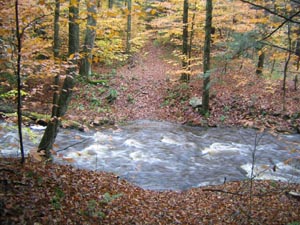 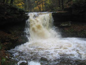
Check out this movie file of Lees Falls gone wild.
Name: Dave Barry
Hike:
Roaring Plains Circuit
Date: 1010/09
Rating: 2
Critique: The Canyon Rim Trail could be a great experience. However, we
missed a least three trail junctions (tee pee in particular) and were in
a somewhat dangerous position for half a day because of it. The trip
ended late with a trip leader with a wrenched knee and gashes on his
face (from a fall) and two participants who would not try it again. The
poor trail documentation and rugged terrain are a dangerous combination.
Big Suggestion for the all trail descriptions - give compass headings
and distances. For instance, the instruction for finding the tee pee
trail is something like "starts behind the campsite a short distance
into the laurel thicket". A much more effective description would be
something like "about 150 yards NW (300 degrees) of the fire ring". By
the way the thicket is actually small pine trees.
We greatly appreciate the huge effort involved in MidAtlantic and the
wonderful hikes it documents. The GPS tracks will be increasingly useful
as more of us obtain that equipment.
Name: Paul Fofonoff
Hike:
Roaring Plains Circuit
Date: 10/10-11/2009
Rating: 5
Critique: I led a trip to Roaring Plains for the DC Chapter of the
Appalachian Mountain Club on Columbus Day Weekend. It turned out to be
the most spectacular but also the most strenuous hiking that I've done
in Mid-Atlantic region, comparable in roughness and dramatic views to
some of the roughest trails in New England, and except in altitude, to
some of the rougher trails in the West. We followed Mike's route up to
the Tee Pee Trail, which we hunted for but could find no trace. We
considered a bushwhack, but instead continued rockwhacking along the
Canyon Rim, following the cairns through a seemingly endless boulder
field. Throughout the route, we had to stop periodically to look for
paths or cairns. We were lucky to have good weather for most of the
trip, as clouds lifted on Saturday afternoon, but rocks and leaves
remained slippery, especially on the Boars Nest Trail (the 'Sliding
Board'). This is one of those trips where you tell yourself 'Never
Again' the day after, and then start thinking about returning as the
aches and scratches start to heal, when you look at memories and
pictures. Mike, thanks, for getting us out there!
Name: Mike from
Richmond
Hike:
St. Mary's Wilderness
Date: 10-10-2009
Rating: 4.5
Critique: Thanks an awful lot for the trail notes -- they were indeed
quite helpful. We just did an out and back to St. Mary's Falls, and it
was fantastic. We were very fortunate to have caught the leaves close to
their height of color and just wished it had been a drop warmer so we
could've done some swimming!
Two notes: 1) On the way to the falls, there's a fork in the road about
3/5ths of the way there that unnecessarily confused us. To the right,
the path goes up a hill into a weird looking field; to the left is a
path continues into the woods. It's easiest to bear to the left
(although on the way back you can cut across the field and you'll figure
out where you are). 2) If you go to the Falls for this out-and-back,
it's downhill almost the entire way there, and respectively, uphill
almost the entire way back. Budget your energy and time accordingly!
Name: Travis Martin
Hike:
AT/Mau-Har Loop
Date: 10-13-09
Rating: 4.5
Critique: Started at six thirty as the sun was coming up.
The first several miles were easy and the up-hills weren't
too steep. Saw a huge pile of fresh bear pooh which had me a
little bit on edge. The long descent down Three Ridges is
when it started to get a little bit tough, because the trail
is made up mostly of sharp, uneven rocks and roots. Hardly a
single footfall is on flat ground, so its crucial to have
boots that can take a beating.
Stopped for a brief rest at Harpers Creek shelter. The creek
was almost completely dry but it looked like a good place to
camp if you are backpacking.
Starting up the Mau-Har trail started to get really tiring
and this was the rockiest stretch, as well as steepest as
you climb out of the Creek. The leaves are turning up there
right now so that made for some great scenery. The final 3
miles were a killer on my feet and knees but I made it back
to the car at 3:30, 8 hours after i started. way faster than
I expected but I didn't make any extra long stops. I was
going mighty slow for the last mile though. I was pretty
beat. This isn't a trail for people who are out of shape or
ill equipped.
Name: The
Tick
Hike:
Trayfoot Mt/Paine Run Loop
Date: 10/10/09
Rating: 4
Critique: This is a good hike. Took us about 5 hours to complete but
we took it slow enjoying the scenery. Beginning sections were a
little steep but over relatively quick. Spent some time at Blackrock
and scrambled up the short distance to the top. Very fun. An overall
fun hike, and once up on the ridge, not a whole lot of energy
expenditure until the end. The rock formations were great
throughout. Saw a bear at the end of the hike but it ran away very
quickly. Mt Paine was a little slow as it was a sort of fire road
type trail but did not look like it was used for that purpose in a
long time. I would recommend this hike.
Name: The Tick
Hike:
Rockytop- Big Run Loop
Date: 10/11/09
Rating: 5
Critique: This is a great hike that I have avoided for a long time
since it was so far south in the park. I was a little apprehensive
at first doing this hike as it is stated that you must be in great
condition and I am in slightly less than ideal shape. Started out
the hike at about 9:30 and it initially starts up a fairly steep
incline. This continued for a short period and in the beginning it
feels like we were coming to trail junctions pretty frequently. We
started up the mountain and although the grade was steep it was not
overwhelming. When we got to the top of Rockytop we sat on one of
many large rockslides and enjoyed the view. Continued on to Big Run
where the decent was very rocky and lots of loose footing. When we
got to the bottom, we got to ford Big Run several times and where
there were many 6 inch trout in one of the pools. Continued back to
the car and ended the hike on a fairly steep grade but thankfully it
was over shortly. Great hike, definitely long but we finished at
4:00 so we never faced impending darkness. Would do again. Great
hike.
Name: Jay
Hike:
Cranberry Wilderness
Date: 09/03/09-09/07/09
Rating: 3.5
Critique: First, great site. Lots of good info here.
My 10 year old son and myself did the Cranberry Wilderness loop as
described here. Positives:If you like solitude, this is your hike.
We never saw another person EXCEPT at the shelter at the forks of
the rivers. Also saw workers coming into the Liming station but I
won't count them either. Saw signs of bear, heard a couple of birds
and rousted some grouse but that was it. Wildlife must not like it
here either. There are some really nice camp sites along the trails.
Pretty easy hike all the way around. We really liked walking through
the pine areas with moss- covered rocks and vegetation everywhere.
Seemed surreal at times. Negatives: Trail maintenance is awful. But
that's why most of us hike, is the challenge. There was a lot of
overgrowth, wading through waist- high weeds, trees, etc. Some of
the trails needed cleared as some places were difficult to get
around, especially when we were going downhill. And if you were not
experienced in back- country trails, there were several areas where
it be easy to get lost. Blazes would be a very good idea.
Reasoning for the
3.5 rating is maintenance and markings. I try to look at this is if
I was going to recommend it to people. My 10 year old is a strong
hiker and he even complained at times. On the other hand, I loved
the solitude and am not sure I want more people coming here. Former
mountaineer living in NC now. Coming here brings back a lot of
memories. Will be back for the other hike soon enough.
M.R.Hyker Note: Read the government
definition of "Wilderness"
here.
Name: Joe Gilvary
Hike:
Pond Run-White Rocks Loop
Date: 10/04/ 2009
Rating: 5
Critique: This is a great hike, for exercise, for solitude, and for
the views. There aren't as many stops to view the valleys as there
are on some other hikes in GWNF, but these were well worth the
effort it took to reach them.
I have two quibbles with the description. The first is really with
the google maps directions. They indicated that I should "stay to
the right" to continue on Waites Run Road. There's nothing there to
confuse a driver. It's better to follow the directions as stated in
the PDF from this site, just drive 6.5 miles up Waites Run Road.
The other issue is an update on the White Rocks Spur Trail. This
trail would be difficult to miss now, as the intersection with
Tuscarora is obvious when a hiker reaches it. The description here
led me to believe that I would find it by searching for a sign on
the right near the start of the "slight decline" in Tuscarora. I
ended up patrolling a downhill portion of Tuscarora several times,
strolling into the trees to look for the sign wherever I thought I
might be seeing a somewhat overgrown trail before I gave up in
dwindling daylight.
After I walked easily some tenths of a mile, I found the
white-blazed trail on the right and still had enough time to walk to
the overlook.
The views of the mountains on this hike are gorgeous. I had a great
day, mostly sunny with temperatures around 60� F.
Name: Darlene
Hike:
Little Devil Stairs
Date: 9-15-09
Rating: 4
Critique: We started our hike from the boundary off of 614 which is
better because you can go up Little Devil Stairs in the beginning
and have a mostly downhill hike coming back. We did the Piney Branch
Trail semi-circuit, so we didn't have to walk as far down the fire
road which can be a little boring. We saw a mama bear and cub, a few
chipmunks and lots of spider webs and only saw one person the 6
hours we were hiking. We accidentally added on an extra mile because
we took the Piney Branch trail in the wrong direction so had to hike
down again, so did a total of about 9 miles. This is definitely one
of my favorite hikes.
Name: Frank Green
Hike:
Ramsey's Draft
Date: 09/06/09
Rating: 4.5
Critique: This is a long but not particularly challenging hike
-- but a great one. The suggested route going up Ramsey's Draft
instead of down it on the return loop is a sensible one. Many
younger Hemlocks appear very healthy. A few of the giants may
still have some life near the top. A caution: there was a small
dead animal, squirrel or perhaps a young possum under the water
in Hiner Spring itself (within the small stone walls). It's hard
to imagine it fell in and drowned. I hope someone didn't do it
deliberately. I think the area at the junction of the Ramsey's
Draft and Shenandoah Mountain and Tearjacket trails is even
prettier than Hiner Spring -- and Shenandoah Mountain Trail is a
gentle joy.
Name: Sara Bird
Hike:
Roaring Plains Circuit
Date: 09/05-06/009
Rating: 5
Critique: Challenging, but well worth it. Spent the night just
northwest of the point. Map and trail descriptions were just
enough to keep us on trail for the most part. Internal sense of
direction didn't hurt, but clearly didn't help when getting lost
on Tee-Pee trail. Trail was marked with flags, but missed a
crucial right hand turn through some boggy area and ended up in
open but barely navigable field of heath thickets. Backtracked
saw the missed flag and were able to continue on out to Roaring
Plains trail with only minimal head scratching. Breaked for
sustenance and wit-gathering at the site of the old "teepee"
What's the backstory here? Anyone?
(M.R. Hyker Note: There is/was an old hunter's canvas tee-pee
standing back in the woods that you could see from the edge of
the small campsite in a thicket. I think it has fallen down
since I last hiked it.)
Thanks for the route and I know I'll do it again soon.
Name:
Marty Shobert
Hike:
Long Pond Backpack
Date: 9/4 - 5/2009
Rating: 4
Critique: Thanks for all of your effort with this website. It's
really a godsend for us "Weekend Warriors" in finding, planning
and executing 1-3 day excursions.
I started from the Ranger Station instead of 15 Mile Creek Rd.
and found a nifty little side trail off of Pine Lick Trail down
to 15 Mile Creek. Soon after leaving HQ, after crossing the
second wooden bridge, turn left on the well-marked trail where
the Pine Lick Trail T's and you'll quickly hit Long Pond Trail
and two of the nicest campsites of the whole trip. I decided to
hike all the way back the same day in order to camp at one! Big
deep pools for swimming, huge rock faces with flat rocks for
stretching out, clear sky view (full moon the night I was there)
and lots of firewood. What more could one ask for? Be sure to
note the intersection of the side trail and Long Pond Trail at
15 Mile Creek, as it's easy to miss on your return trip.
I also go to Dolly Sods, but this hike is a miniature version
with half the drive for me from Baltimore. Great hike...can't
wait to go again.
Name: Steve
Hike:
Old Rag
Date: 9/02/09
Rating: 5
Critique: I went on a cool late summer Wednesday arriving about
9 am at the secondary parking lot. I hoofed it from the parking
lot up to the trail head and set out on the blue trail.
I suggest you try parking at the main lot directly at the trail
head unless you want to add on an extra 2 miles to the loop. The
main lot by the trail head was packed even on a Wednesday
morning though.
Normally when I go hiking during the week I don't run into
anyone else. In this case, I bumped into a young couple several
times during the climb and we stopped at some of the same places
to take in the views. During the rock scramble (which is awesome
and something I had never experienced) I passed a group of 3
people, 2 women and 1 man, about 50 years old. I think this can
be completed by anyone in reasonably good shape though it was
fairly difficult for an office dwelling "treadmill athlete" such
as myself.
The rock scramble is really like easy rock climbing in many
places (which is pretty hard actually) and is something you
can't experience too many places on Earth but especially the
East Coast of the U.S. There were multiple points along the
trail where I found it hard to believe that the trail actually
went where it did and I was dumbfounded that someone must have
been the first one through there and decided it was a good place
for a hiking trail!
The physical requirements aren't too steep but you should be
confident in your strength, balance, and ability to overcome any
fear of heights. It would certainly be possible to fall and be
seriously injured while doing the rock scramble
Name: Jason
Hike:
Dolly Sods Circumnavigation Mod1
Date: 8/21/09-8/23/09
Rating: 4.5
Critique: First, thanks to Mike for this excellent website and for his
quick replies to my email inquiries. We intended to do the Dolly Sods
Circumnavigation Mod trip, but made a few changes to our itinerary due
to a late start on Friday (driving in from Michigan and Ohio). The two
changes were: 1) did not hike the Harman Trail/Blackbird Knob Trail
loop, and 2) used the Dobbin Grade Trail on our return versus Raven
Ridge Trail and the unofficial by-pass (wish we hadn't made this
decision).
We started from the Bear Rocks trailhead at 6:30pm on Friday and arrived
at the first campsite at the Red Creek crossing around 7:00pm. This was
an excellent campsite that holds maybe 4-5 tents right along Red Creek.
Nice fire pit as well, although we didn't have a fire (too wet, too
late). We did hear some wild dogs howling on the ridge around 4:00am,
but otherwise an uneventful night (not counting our bear bagging
experience, which is always eventful).
Day 2 started early with an incredible hike up Raven Ridge and along
Rocky Ridge. This is the highlight of the trip as far as views are
concerned. The trails were fairly flat with only a few short climbs. The
main challenge is the lack of signage in certain places, mud and bogs
and rocky sections. As mentioned, we bypassed the Harman/Blackbird loop
due to our late start on Day 1. Continuing south along the Rocky Ridge
Trail was incredible with several large rock formations and views.
At the kiosk at the intersection of the Breathed Mt Trail and Big
Stonecoal Trail, we missed a trail sign and simply headed to the right.
About 20 minutes later we realized we were on Public Road 80 and
back-tracked where we found the sign for Big Stonecoal Trail.
Rocky Point Trail certainly earns its nickname with at least a few miles
of some of the rockiest trails I have hiked. Also, there was some
confusion among our group and another group as to which route to the top
of Lions Head was the "best". We chose the second cairn, which led us up
a confusing and overgrown path, then to some nice rock scrambling to get
up top. We came down the same route. Lions Head was incredible and worth
the navigational effort.
We camped at The Forks. There are several campsites in this area, some
better than others. Make sure you walk around and up the trail to survey
all of the sites. We had actually decided to move on to Blackbird Knob
to camp and passed a nice site while hiking out of The Forks campsite.
It had room for several tents and was right along Red Creek. Two nights
sleeping with water in the background was perfect and I slept better
than I've ever slept while hiking. Day 2 was some of the best
backpacking I have experienced.
Day 3 was a short hike out, but not without some great mud bogs and
river crossings. The crossing of Red Creek at the intersection of Upper
Red Creek Trail and Dobbin Grade Trail was a nice rock hop. We chose to
hike the Dobbin Grade Trail instead of Raven Ridge. This turned out to
be a mistake as Dobbin Grade was very muddy with plenty of mud up to
your ankle moments. Given it was our last leg, we were happy to play in
the mud and clean up at the trailhead. The Raven Ridge Trail could be
seen higher up on our left as we mudded our way through.
Overall this was an awesome hike. One I would recommend to anyone who
has some experience in backpacking and reading a map. There are some
sections that are under-signed, however it certainly didn't detract from
the trip. I look forward to returning to the area.
Name: Cory Davis
Hike:
Difficult Run Loop
Date: 23 Aug 09
Rating: 4
Critique: Overall a great hike. My first hike in over a year and just
felt so great I didn't want to stop. The trail is in great condition and
the folks along the trail were very friendly. Just a note that the River
Trail now has "teal" colored blazes rather than blue. Thanks for the
great trail notes.
Name: Kevin
Hike:
Little Devil Stairs
Date: August 16, 2009
Rating: 4
Critique: A very nice hike! The directions to the start and the
description of the hike are very accurate. The beginning is tough but
enjoyable. I brought my two sons, Ryan-12 and Shane-9 and they had no
problem. They enjoyed the small waterfalls and pools. Lots of neat rock
formations. Saw many fat red centipedes and butterflies but no other
wildlife. We took the short way back on the fire road which they thought
was sort of boring. The oldest wished he had lugged a folding bicycle in
the backpack to ride down, which you could have done. You can also run
down if you pack running shoes. I am going to hike it again during rainy
season to see some faster running water.
Name: pat
Hike:
Morgan Run
Date: 8/08/09
Rating: 5 (-3)
Critique: The path leads through beautiful, heavily forested areas with
a few open spaces. Isolation takes on special meaning as during perfect
weather on Saturday, I walked alone - never seeing another hiker. Big
problem was staying on route after Poole Rd. Got lost and after more
than 2 hours, was rescued by knocking on a neighbor's door.
Name: Bob Parker
Hike:
Patterson Ridge-Big Run Portal
Date: 08/04/09
Rating: 4
Critique: Ran the hike starting at Doyles River Parking and skipping
Frazier Discovery by using the campground trail from the camp store. Met
a large bear near the Loft Mountain Camp store enjoying the local
berries. Patterson Ridge was a knee crunching descent with limited views
and occasional rough trail. The Big run portal was a nice hike, the
first campsite on the map was hard to locate and the second had been
marked no camping by the Park service
(M.R.Hyker Note: The campsite is about 30
yards downstream from that sign on the opposite side of the trail.).
The climb back out on Big Run Loop is much easier than expected with
good trail conditions.
Name: Kylena Cross
Hike:
Catoctin Mountain
Date: 7/25/09
Rating: 4.5
Critique: I have hiked Catoctin many times and have avoided hiking along
the stream/Rt 77 because of traffic issues. Otherwise it is a fantastic
place to hike. The hills aren't too bad in terms of steepness. However,
if you need to stop and catch your breath you can do it without someone
on your heels as long as you hike during the week or in the early
morning.
Always a caution at Catoctin is whether the president will be at Camp
David...if he is then some of the trails will be inaccessible. Check
before you go!
Name: Vern
Hike:
Kelly's Run - Pinnacle Overlook
Date: August 1, 2009
Rating: 4.5
Critique: I've been thinking about doing this hike for several weeks,
but avoided it, because I thought it might be a little too short. Well,
was I ever wrong. As Mike indicated, this one seems a lot longer then
the advertised 5.5 miles.
The only problem I ran into, was after crossing Kelly's Run at the
bridge. I'm not sure if I was right or wrong, but I followed an unblazed
trail along the railroad tracks, rather then continuing on Kelly's run.
Eventually, it turned up hill, and connected with the Conestoga Trail,
right at the underground utility line. From that point, it sure was a
fun climb to Pinnacle Overlook. The views along the way were
outstanding.
After lunch at the overlook, the hike along Kelly's Run was beautiful.
There were several pools of water that looked really inviting, since it
was in the high eighties and humid. By the time we arrived back at the
ball field, I was thoroughly worn out and thoroughly soaked.
It's easy to add a little distance to this one by continuing up the
Conestoga Trail after the overlook. I personally did not see any need to
do that and I had a real ball.
Name: Lydia
Hike:
Old Rag
Date: 7/19/09
Rating: 5
Critique: My partner, Kate, and I went out and hiked Old Rag in the
morning to beat the crowds. The last time I was there, there was a
bus full of boy scouts and we went up the back way and missed part
of the scramble. I love this hike and think the upper body and mind
challenges it gives in addition to the leg workout, is awesome. My
heart is full and I'm waiting till I can walk without a cane again
to return.
Name: Greg
Hike:
Kelly's Run to Covered Bridge on Conestoga Trail
Date: 7/18/09
Rating: 4
Critique: We sort of pieced 2 hikes together to make a long day hike
with some decent elevation gain. We started at Holtwood Recreation
Area and hiked down Kelly's Run, then proceeded on to the Pinnacle
then up the Conestoga Trail past the Wind Cave to the covered bridge
about 1.3 miles before Martic Forge, then turned around and hiked
back to the car. On the way back, we skipped the Tucquan Creek
detour, and also took the meadow walk Kelly's Run return trail
instead of back along the run itself (our feet were tired). We had
wanted to go all the way to Martic Forge, but it was getting late,
and we had a LONG way back to the car. By GPS, total hike was 21.1
miles, with 6,062 of elevation gain. A pretty good jaunt.
First of all, the little green pamphlet from PPL containing the map
to the Kelly's Run area really STINKS. Just about worthless.
Second, the Tacquan Creek portion of the trip is a bit confusing, as
there are blue blazes on both sides of the creek so we were left
wondering which ones we should follow. Eventually, I figured out
that they both led the same place, but it slowed us down
considerably.
The Conestoga Trail for the most part is blazed pretty well;
however, there was one part near the Tacquan Creek area where a
blaze indicating a change of direction was nearly impossible to see
because the tree it was on was leaning in the direction you were
coming from. We missed it, and ended up taking a .25 mile detour
before we turned around. Then we wandered back and forth trying to
find the orange blazes again, before my hiking partner finally
noticed the blaze on the leaning tree. Kind of a pain.
We weren't the only ones complaining about the blazing either -- we
met 4 others groups (including a nice couple who did an AT thru hike
last year) who were having issues following the balzes.
All in all, a decent day, but some of the trail marking is a bit
suspect. Coupled with the fact that there aren't any good maps of
the area makes this one a bit of a challenge.
However, the hike we did does have some good elevation change, so if
you're looking for a good strenuous hike close to Philly, this one
is pretty good. Nothing else I have done within a 2 hour ride of
Philly comes close.
Name: trail-god
Hike:
Chuck Keiper Trail-East
Date: 10/08
Rating: 5
Critique: great trail but hard. many great views. Good experience.
Name: Vern
Hike:
Mason - Dixon Shuttle
Date: July 13, 2009
Rating: 4.5
Critique: Hard to imagine that no one has reviewed this hike. I had
a fantastic day there yesterday. The weather was as good as it gets
in July. It was around 75, and not a cloud in the sky. I did this
one as an out and back, since I was by myself. It was definitely a
full day of excellent hiking with sore muscles as a welcome side
effect.
The only part of this hike that might be considered remotely boring,
is the short walk along River Road. Even here, you have outstanding
views of Holtwood Dam and Lake Aldred. I had lunch lakeside, with a
beautiful view. The walks along Mill and Oakland Runs were
outstanding. Mill Run had a particularly nice waterfall. Between the
two streams, there was a good-sized hill which had some freshly cut
switchbacks and two excellent overlooks. Even with the switchbacks,
this hill was a real lung capacity test.
The M-DT is well marked in this section, and it is just "rough"
enough to make it really interesting. I saw loads of deer, and a
couple of copperheads. Only came across two other groups during the
entire hike. This one is going on the "do again" list without a
doubt.
Name: Jos� Calvo
Hike:
Old Rag
Date: 7/6/09
Rating: 4
Old
rag is an old favorite and I recently re-did the hike - it did not
disappoint. I would highly recommend getting there early OR LATE to
avoid the crunch in the upper parking lot. That might be the one
downside - the hike is so popular that you're unlikely to have your
own space or silence for long. The plus is lots of friendly faces or
commiseration if you're into that sort of thing.
Old rag remains unique for combining a difficult hike with some very
unusual rock formations that require scrabbling and even upper body
strength to lob your limbs up cracks and across a sheer cliff-like
face here and there. I would not do this hike alone unless you are
able to lift your body weight on your hands & arms (think push ups
or better yet "dips)." The rocks make this a really fun hike.
In the summer most of this hike is in the shade, but of course the
top 1/4 mile or so will expose you to a lot of sun.
Great views along the way so if you need an excuse to stop and pant,
you'll get them.
Biggest downside might be how long that fire road seems at the end.
It's easy to do, but by the time you get to it realizing you have
over 2 miles to go, and go, and go is just painfully dull.
J
PS
thank you for the fantastic web site - I've been neglecting hiking
for many months, but your site (still bookmarked in my browser)
makes it really easy to scope out the old haunts.
Name: Jos� Calvo
Hike:
Old Rag
Date: 7/6/09
Rating: 5
Critique: Hey! Hey!! HEY!!! This isn't really a critique so much as
an alert - your driving directions are wrong! The google maps link
works fine, but if you follow the route it sends you on you cannot
get to old rag at all. In fact, it's been wrong so long that some
VERY NICE PERSON put up their own homemade wooden sign at the turn
that says "Google maps is wrong!" and gives directions that will get
you to old rag.
So - yes loved the hike as everyone does, done it many times, but
please update your site to give directions NOT GOOGLE MAPS :)
Thank you!
MRHyker Note: More
detailed directions are in the Trail Notes. A suggestion to use them
are now noted after the Google Map Directions.
Name: Josh
Hike:
Little Devil's Staircase
Date: 7/5/09
Rating: 5
Critique: This is my absolute favorite hike in Shenandoah National
Park. Though you don't get the views that Old Rag or Hawksbill
Summit offer, you get an enjoyable hike, a bit strenuous at times,
with an active stream. The pools of water are populated by several
species of salamanders, frogs and snakes, so enjoy looking under
rocks. You will likely pass other hikers on the trail, but it will
be quiet for the majority of your time. Wear sturdy shoes, as the
rocks on the 'Devil's Staircase' are often slippery/slimy from the
stream and can result in tumbles. My six and eight year-old
completed the hike today (5.4 miles), so take your kids!
Name: C Griffin
Hike:
Dolly Sods Wilderness
Date: 06/27/09
Rating: 4.5
Critique: I extended the trail somewhat since we were going to
have 4 days there. We did Red creek - Little StoneCoal -
Dunkenbarger - Big StoneCoal - Blackbird Knob - Red Creek -
Rocky Point - Big StoneCoal - Red Creek. Hands down the most
diverse and beautiful scenery I have ever seen. The stream
crossing on Dunkenbarger looked more like a Botanical Garden
than wilderness! We camped there our first night. We found a
nice campsite in a pine forest north of the creek crossing on
BlackBird Knob. We put in a long day on day 3 to see Lion's Head
which did not disappoint. We spent the night on a nice open area
along the junction of Big Stonecoal and red creek our last
night.
Tips - Make sure you wear comfortable shoes/boots. The rocky
trails are no joke and can make the hike unpleasant if you are
not careful. There were signs of bears, make sure you are
prepared to hang your food, etc. Try to avoid filtering water on
the stream/creek at Blackbird Knob - the iron content is so high
that it pretty much ruined a brand new filter. I wouldn't bring
kids on this adventure, I have a 7 year old that I normally take
with me. Glad I didn't on this one, some of the trails are a
little to physically demanding I think.
The only reason I will not give it a 5 out of 5 at this point is
because I am sure there is a true 5 out there that I have not
been able to visit yet.
Thank you Mr. Hyker for all of the good info. It made navigation
very easy. I would recommend this trip to anyone and everyone
looking for a nice mixture of solitude and scenery!
Name: Steven
Powers
Hike:
Cat Rock Circuit
Date: 6/27/2009
Rating: 4
Critique: Definitely a great hike... Not Old Rag great... but
still great.
The only critique I have about this is that the first leg of the
hike (Fisherman's Path) is a little vague, hard to find, and not
an official maintained trail.
Better directions would be to simply follow the stream or the
road to the cat rock trail head.
The fisherman's path itself is overgrown in most areas and
impossible to follow.
Another problem I had in following these directions was that the
gravel path that was supposedly near the falls is no longer
there. Its all boardwalk now a days. If you do follow the only
existing gravel path you will end up at the lake... which is not
where your supposed to go.
Do watch out for snakes... I saw 3 (1 rattler) within the first
2 miles.
Name: Jimmy
Bair
Hike:
Dolly Sods circumnavigation Mod 1 (sort of)
Date: June 5-7, 2009
Rating: 4
Critique: My 12yo son and I set out to complete this walk the
first weekend after school let out for the summer. Little did I
know that the days leading up to our hike would bring heavy rain
to the sods. On Friday morning we drove up the fire road in
driving rain and fog. We delayed our hike until the afternoon
which was only slightly better with steady mist and visibility
of about 20 yards.
As we moved off the fire road we found the trail nearly
impassable about 200 yards in. after an hour detour around
several run-offs, we came upon the trail and followed it up the
ridge. The trail condition improved and we rambled on to the
intersection of Bear Rocks Trail and Dobbin Glade Trial.
We took a break since the rain and mist kind of stopped. We
could hear Red Creek off in the distace, but visibility hadn't
improved so we didn't know what lay ahead.
We found Red Creek to be rushing over its banks. The stepping
stones marking the trail lay 3 or 4 feet below the rushing
water. After checking up and down stream with no luck finding a
better ford, we decided to head down Dobbin Grade trail to see
what we would find.
Dobbin Grade trail was impassable about a quarter mile from Bear
Rocks Trail.
We decided to head back to Bear Rocks Trail, turn right head up
to the ridge and find a camp. We settled in and sacked out in
the fog.
The next morning we awoke to brilliant clear skies and perfect
temperatures. We headed down the trail to find Red creek
passable and set off for Rocky Ridge. the scenery and weather
were beautiful. After lunching at the rocks on the ridge we
decided to stay on the ridge for the evening. We made camp at a
very cool campsite below a giant boulder about five minute walk
before the trail takes you over the boulder hop. We spent the
rest of the day exploring the ridge. We hiked down to the
intersection with the Dobbin Grade Trail, then back to the ridge
for dinner.
Sunday morning dawned just as beautifully as Saturday. We took
our time backtracking over the last two days' hike and returned
to our car by 1pm.
This is a beautiful hike, and even though the weather thwarted
our attempt at circumnavigation, we had a wonderful time. We
will surely be back.
I found the trail conditions to be just what we expected. One
observation (criticism?) I have is the seemingly lack of
forethought to trail signage. I have no problem with the lack of
signs, (We wanted to go to the NF to practice our navigation)
but I don't understand why areas like the glades going up Raven
Ridge Trail where you can easily identify the trail from a half
mile away are heavily signed, but when going through Spruce
groves where you can't easily identify the correct trails aren't
signed at all.
Thanks to Mr. Hyker for the advice and a great website!]
Name: Strawman
Hike:
Hogback Mountain/Knob Mountain Loop
Date: 6/27/09
Rating: 4
Critique: Did the 10.3 mile loop version of this hike on a
beautiful June day. The hike was quite nice, with some great
overlook views. Also plenty of wildlife to watch, including a
rattlesnake sunning itself on the Keyser Fire Road, and a black
bear with her two cubs between Elkwallow and Matthews Arm. The
only downside of the trail was its frequent proximity to Skyline
Drive, and the associated noise. Overall a very nice hike that I
would do again.
Name: Brandon
Hike:
Grayson Highlands - 2
Date: 5/29/2009
Rating: 5
Critique: I did this the Friday after Memorial Day. I was
planning on making it a 2-3 day excursion earlier in the week,
but all it did was rain and I really didn't want to deal with
it. So Friday's forecast was non-rainy, so I did this simply as
a dayhike.
I did the route described, except I also hiked out to the top of
Mt. Rogers, and I did this counter-clockwise. So it was 15-16
miles. Thankfully the elevation change was never anything crazy
- I never needed to stop for a break, just for the many many
photo ops.
I'd say the most "boring" area was Little Wilson Creek
Wilderness - just a walk in the woods. Don't shortcut it though,
because north of it is Stone Mountain and the best
landscape/views of the hike.
Sadly the rhododendrons were still prepping when I was there, as
I didn't see any blooms. The ponies didn't disappoint though! On
this day, they were pretty much all around the Wilburn Ridge and
Thomas Knob shelter areas. I'm not sure how many hikes feature
the sounds of a hiker begging a pony to stop chewing on his
tent.
Name: Rob
Hike:
Old Rag Mountain
Date: 6-21-09
Rating: 5
Critique: I have lived in Wyoming, Colorado, and Idaho. While
this may not have the solitude of a hike into the southern
entrance of Yellowstone Park, it was one of the best hikes I
ever had east of the Mississippi.
I went by myself and got there at 1pm on a Sunday. This was a
perfect time and I was able to park in the upper lot.
The trail up to the scramble is a consistent incline and very
easy. The rock scramble was awesome and much more impressive in
person than described anywhere I have read.
However, I was not able to complete the circuit and I got rock
jammed at the minor summit. I spent 20 minutes trying to figure
out how to get through a crevice/fissure that was narrow, tight,
and slick on the sides. I tried over and over to put my back
against one side and use my feet to push up against the other
side to no avail. I was so pissed as I wanted to get to the top
badly. I did not run into anyone while struggling so I am not
sure if I was lost or what though the blue blazes were all over
the walls of this thing. So I turned around and went back.
Despite not summiting, I still enjoyed the trek!
Name: Jason
Hike:
Rocky Mount
Date: 6/17/09
Rating: 4
Critique: Definetly a strenous day hike but the two major climbs
are spaced out nicely, so you don't get too worn down. Hike to
the peak on Rocky Mount is the most strenous section, but views
from the cliffs at the top are great. If you parked at Two Mile
Overlook you can even see your car from one of the cliffs.
Hike down Rocky Mount into Gap Run is very non descript but the
Gap Run tributary is a nice reward. The tributary is an idyllic
oasis after coming down the rocky slopes of Rocky Mount. Trail
was muddy at times in the Gap Run area and while initial
crossing of Gap Run could result in some wet feet if the water
is high, other crossings you can almost jump over.
Stopped for lunch near Gap Run and had a black bear come up
within 25 feet of us. I'm not sure if it noticed us, if it did
it cleary was not interested.
Hiked this on a beautiful Friday and saw one other hiker the
whole day, so expect isolation, as this hike is only for those
looking for a hardy day hike. There are a couple nice camping
spots in the Gap Run area so this would make a nice short
backpack as well. One other thing, hike this is the direction
stated on the website. The hike up Rocky Mount the other way
seems brutally steep.
Name: Dave &
Tina
Hike:
Cold Mountain Loop
Date: 06-20-09
Rating: 4.5
Critique: This is a great hike. Not too hard not too easy. Great
views. The only thing is the whole accessibility issue. The
roads to get to the trail head are horrible especially if you
have a low car. Must enter/exit from the west end of Wiggins
Springs Road, else you will get stuck or on a dead end!!
Name: Matt Janes
Hike:
Kelly's Run-Pinnacle Overlook
Date: 6/19/09
Rating: 5
Critique: Awesome hike! The views of Lake Aldred and Kelly's Run
were great. I did this hike a day after some rain, which made the
hike up the Connestoga Tr., and crossing Kelly's Run, a little
precarious. My suggestion would be do this hike at least 2 or 3 days
after rain, so the rocks have time to dry. I managed it alright
regardless, but a less experienced person may have problems. The
only down point was the short stint on the Pinnacle Tr.; which was
very thorny as it mentions in the notes. Overall, I think this was
the most beautiful hike I've done this season!
Name:
Matt Janes
Hike:
Susquehanna State Park
Date: 6/6/09
Rating: 4
Critique: Great circuit. The info on the trail notes was very much
needed at some of the more confusing parts. The giant beech tree,
and oak tree were awesome! I took my time talking to people, and
taking pictures; and still completed this in about 5 hours. Thanks
for all the info!
Name: Mark
Hike:
Rohrbaugh Plains/Dolly Sods Shuttle
Date: 6/13-14/2009
Rating: 5
Critique: We made roughly the same hike as the other reviewer,
making this hike into a 2-day loop hike by camping at the un-named
overlook. This is great hike as an introduction to Dolly Sods and
backpacking, as we took my brother-in-law for his first trip out. I
think the climb up Fisher Spring wiped him out, but the view made up
for it. Plus we met some fellow campers at the Fisher Spring
trailhead and they gave us a lift back to my truck at the Blackbird
Knob trailhead. I didn't use the GPS on this one as we have hiked
almost all these trails before, so I was familiar with the
intersections. The overlook was spectacular as usual, we watched it
rain all around us Saturday evening but never felt a drop. The only
disappointment was I wish there was a trail connecting Fisher Spring
to Blackbird Knob on the east side of red creek so road hiking
wouldn't be necessary, but I guess getting a lift makes that easier.
After the hike we had another great pizza dinner at Sirianni's Cafe
in Davis.
Name: Vern
Hike:
Catoctin Mountain Loop
Date: 6/13/09
Rating: 4
Critique: I also did the 8.5 mile walk advertised on the NPS web site.
The route is basically the same, with the exception of the walk along
the stream and Route 77.
I set out early in the morning, and for a few hours, I had the park to
myself. Until I reached the trail that leads up to the falls, other
hikers were very few and far between. Basically, I ran into people at
each vista, and of course there was a mob scene at the falls.
Of all of the vistas, Hog Rock was the best view in my opinion. Chimney
Rocks had the most interesting rock formations. Be careful not to drop
your glasses at Wolf Rock. Some of those crevices are very deep. Lucky
mine ended up in one that was only two feet deep, but others looked like
they might be more then twenty feet.
This was a very pleasant hike, and the moderate rating is right on.
There are a very few areas that might be called strenuous, particularly
when the moss-covered rocks are wet. My guess is that this will be a
beautiful hike in the fall, when the leaves are changing colors.
Catoctin is a beautiful park and is well worth the trip.
Name: Anne
Hike:
Kelly's Run- Pinnacle Overlook
Date: 6/13/09
Rating: 4
Critique: Great hike!
Some areas were poorly blazed, which made things confusing, and the
cornfield is now filled with wheat, but it was certainly a fun day-hike.
Name: Susan Neill
Hike: Buck Hollow-Buck Ridge
Loop
Date: 6/13/09
Rating: 3.5
Critique: This is an interesting trail, but doesn't have as much variety
that I like, so I'm giving it a rating of 3.5. The descent into Buck
Hollow is a bit steep (though nothing like what's to come). The site is
humid/moist and there are lots of beautiful old tulip poplar and some
white oak, among many other hardwoods. The place had a tropical feel to
it. The day was not hot but very muggy and buggy, which obviously added
to the atmosphere. As I walked, I wished the trail got closer to the
run, which is close enough for pictures but a ways off until about mile
2.8, where the trail crosses a wide section of the stream. Human traffic
along the descent was a bit heavy for my liking.
The ascent up Buck Ridge: I'm really a novice hiker (I don't even have a
walking stick yet) and this was the most strenous trail I've been on.
There are terraced steps for about a third, which help. Eventually,
though, the steps end and the trail's surface becomes very rockier and
the slope steeper. I'm probably exaggerating but it felt like a 60
degree angle. The sloap does become more gradual but the trail goes up
and down until the end. The ridge is pretty (but no full views) and the
trail winds in and out of boulder fields among a lot of mt. laurel. In a
less rocky section, a bear crossed the trail behind me. The trail
eventually narrows a lot. Lots of berry shrubs along here; bear food
when they ripen.
Name: Mark
Hike:
Dolly Sods North BP
Date: 5/24-25/09
Rating: 5
Critique: This hike made me realize how out of shape I am coming
out of winter, but my burning legs couldn't dampen my spirits on
this beautiful hike. Absolutely outstanding. Dolly Sods is like
no other area in the Mid-Atlantic, and this hike really shows
it. The only disappointment was at Harmon Knob where we noticed
a larger than normal group of people and a bench. Upon walking
down to the overlook we found a road and trail just below;
somewhat disheartening after hiking in roughly 6 miles the hard
way. The campsite area was very nice, with 4 nice sites and
several other spots you could stay if it filled up. We will
definitely make this trip again.
Name: Ryan Culloty
Hike:
Catoctin Mountain Loop
Date: 6/6/2009
Rating: 4
Critique: I did the 8.5 mile hike starting at the visitor's
center and heading north on the trail in lieu of walking along
the road/stream. This is the map:
http://www.nps.gov/cato/planyourvisit/upload/8mileL.pdf
I found the hike to be strenuous at times and the trail somewhat
rocky, but a very enjoyable experience. Most of the vistas had
poor visibility due to trees blocking the view - I suggest
visiting in the winter after all the leaves have fallen.
Name: Peter
Hike:
Laurel Run - Falls Ridge
Date: 06/08/09
Rating: 4
Critique: After parking, Falls Run (little stream) is to the right
of the single family home located at the end of the road. There is a
trail to the left of the single family home which is not where you
want to go.
Beyond that, follow the provided directions and enjoy your outing.
If you plan to backpack and camp, the last water stop, that is easy
to access on the route, is just before the small pond (could be dry
in late summer?). It's a little spring next to the trail. We filled
up before the spring near the recommended break-point. After the
break the trail climbs away from Laurel Run to SR691.
Have fun, great hike.
Thanks Mike
Name: Garrett Socling
Hike:
Black Forest Trail - Southern Loop
Date: 6/6/09 - 6/7/09
Rating: 5
Critique: Enjoyed every portion of this hike. We did it in two days,
13 miles from parking to Little Slate Run on day one, 11 miles from
Little Slate Run back to the parking on day two.
The weather was perfect if just a tad warm at around 80'F down in
the valley bottom. Thankfully a little cooler up top!
Only wildlife we saw was two turkeys we scared out of trees at
various points, and one rattlesnake that we scared off the trail on
day two.
I took extensive photos to enhance the guide and the Black Forest
Trail - South description.
Photos can be viewed here.
The new management of The Waterville Tavern and the poor ambiance at
the Pine Creek Lodge chased us down into Jersey Shore. We highly
recommend The Tiadaghton Inn in Jersey Shore for good food, good
service and an excellent ambiance. They have two dining rooms and a
separated bar, so reservations are rarely necessary.
Name: Steve
Weber
Hike:
St. Mary's Wilderness
Date: 5/30-31, 2009
Rating: 4
Critique: The Rhodos and mountain laurel were in full bloom
making for a picturesque trip. Your trail notes and topo were a
huge help. The side trip to St. Mary's Falls made this a perfect
length for a weekend backpack. The group campsite you suggested
was fantastic. Day 2 with the road walk was less exciting than
the hike on Day 1, but someone or group must have cleaned up the
fire road, there was very little litter. Thanks again for all
you do, Mike.
Name: Reid
Hike:
BFT (total loop - 42 mile)
Date: 5/21/09
Rating: 4
Critique: Great hike, tough as nails though. The elevation
changes are no joke, and the steep inclines can be treacherous
with a full pack and will slow you down. Overall a great hike,
though, and the weather was perfect but for a sprinkle on the
third day in.
We did the whole loop over the Memorial Day weekend, in on
Thursday, May 21, and out on Monday, Memorial Day. Did the route
backwards from the prescribed route, and saw few hikers coming
the opposite direction, and had little trouble finding space at
the campsites.
WATCH OUT FOR RATTLESNAKES. We surprised at least two big
suckers right on the trail during the hike. Other than some wild
turkeys and the rattlesnakes, we did not encounter much wildlife
to speak of.
Only complaint: when we hiked out, we were all hankering for our
post-hike burgers and beers, and headed immediately for the
former Waterville Hotel (now the Waterville Tavern) that had
been suggested by many other hikers. We had nine campers in our
group, and they wouldn't push two tables together to accommodate
us, because "the owners don't want us to push tables together"
as the waitress told us. Needless to say, they lost our business
(well over $300) to the Pine Creek Lodge (I think is the name?)
down the street. DO NOT GO TO THE WATERVILLE TAVERN, as it seems
they don't care for hikers' business anymore. The Pine Creek
Lodge served us wonderfully, and all future hikers of the BFT
should take their business here instead of the Waterville
Tavern.
Name: Noah
Hike:
Ramsey's Draft
Date: 01/30-02/01 2009
Rating: 4.5
Critique: Went with a group of 5. Numerous camp sites right at
the head of the trail so driving up after work on Friday and
spending the night is very easily done. The draft was flowing
well but iced over in a lot of places. The numerous crossings
proved a little difficult in some places cause of the ice but we
managed. Camped at Hiner Spring. Lots of bear tracks, saw a few
deer. Hiked out the next day along with some very nice vistas,
but also very icy along the trail. Was a great hike, will be
back with my fly rod for some of those native wild brook trout I
saw crossing the draft.
Name: Keith
Lehman
Hike:
Big Schloss
Date: 5/17 - 5/18/09
Rating: 5
Critique: What a completely wonderful hike! Had a little trouble
finding my way in as FR92 isn't marked from the intersection
with 675. You'll know you made the right (left) turn if you come
to a relatively fresh logging clearcut on the left as you go up
the road.
The first section along Little Stony Creek trail was rather
muddy from the weeks of rain prior to my trip. I expect it would
be fine any other time and the mud wasn't deep and could be
avoided. There are no stream crossings so the high water wasn't
a problem.
The trail was beautiful with the creek views at first giving way
to blooming laurel as I ascended to the Sugar Knob cabin.
After the haul up to the ridge to Mill Mountain Trail the going
was pretty easy. The campsites really aren't that great until
you get to the one's near Sandstone Spring. They all looked
really nice. However, I wanted to camp on the ridge so I filled
up on water at the spring (necessary as there was no more water
even with the heavy rains).
The campsite at the overlook about a mile beyond the spring was
outstanding. The nearby cliff overlook gave me a great view of
the valley and the sunset. The winds were high but the campsite
is relatively protected so it wasn't bad at all. You could
probably squeeze two tents in at this site.
The views from Big Schloss are the best in the area. What a
marvelous place to relax for a nice lunch. There is a small
campsite at the peak but it may not be all that private as I met
a few day hikers even on Monday.
The hike back to the car from the peak was a little bit brutal
as it's fairly steep and the last half mile or so is in the sun
while walking on the road.
This is now one of the few hikes that I will definitely do again
and will use to hook my friends on backpacking. It's probably
the best hike within easy reach of DC.
Name: Vern
Hike:
Sugarloaf Mountain
Date: May 24, 2009
Rating: 3
Critique: This was a fun little hike. The only problem is that
it was over way too soon! There are a lot of good views, for
very little effort.
It was Memorial Day weekend, with temps in the eighties, so the
mountain was busy and full of families with young children.
There sure was a lot of noise going on at White Rocks, so we
only stayed long enough to choke our lunch down. Of course the
noise did not prevent us from getting some great photos.
Most of the trails are quite rocky, but all in all, they are
well maintained and well blazed. The views from each of the
vistas are outstanding.
Please note that a map or some other navigational aid is
necessary. The trails are a bit confusing, and I ran across one
person who was just plain lost. The trail description and map
provided here makes it easy.
Sugarloaf is worth the trip, I'm just not sure I would go out of
my way to repeat.
Name: Ian
Hike:
Morgan Run Loop
Date: 5/16/09
Rating: 4
Critique: Good hike and of good duration given the proximity to
suburbia. The trail description here is very accurate and makes
navigating the numerous intersections easy. Pretty stream
crossings and water views abound. The ferns and other
groundcover in the pine plantations is a verdant green in
spring. Had it been warmer we may have enjoyed the swimming
hole; our dog certainly did!
Two minor downsides: Ticks. There are numerous grassy areas. We
easily picked up 6 or more per person on this one and our dog
came home with several new "friends" despite her Frontline
treatments. The second is the 1/2 mile on Rt 32 to complete the
loop. There is not much of a shoulder on the bridge and cars fly
past at 50mph.
Name: Brandon
Hike:
Red Creek/Big
Stonecoal Circuit
05-10-09
Rating: 5
Critique: I did this as a day hike.
The best thing about this hike are all the waterworks. And even
though it was a very nice Sunday, the solitude as well. Only saw 1
large group the whole 7-hr day.
The worst thing is that Rocky Point trail is a spirit killer. You
have to endure a mile of basically walking on a rock bed. I stubbed
my toes and had awkward landings many times while on it.
I have yet to find an "official" trail to the Lion's Head, and today
was no different. Thankfully bushwhacking here is easy.
Also, note that fording Red Creek @ Big Stonecoal is a little deeper
than at Little Stonecoal or the fording at the Red Creek trail.
Name: RMS
Hike:
Kelly's run/Pinnacle overlook
Date: 5/9/09
Rating: 5
Critique: What a great hike! Good job on the description. Kelly's
Run was very high due to the recent rains making the crossings very
interesting. The hike is of varied terrain and is strenuous when
taken at a good pace.
Name: Vern
Hike:
Susquehanna SP
Date: 05-10-2009
Rating: 5
Critique: I never knew about this park until I saw it here. This one
ended up being a fantastic hike. It started off along the river on
the Mason/Dixon trail. The first couple of miles were all very
level, and it was a fairly easy hike except in the few sections
where the rail bed had been washed away. After turning away from the
river, there were some impressive elevation changes. In fact, at the
very end of the hike the trail seems to tower over the treetops at
the river level.
Along the way, the trail passed through several pastures, and also
some very dense foliage. It was a beautiful day, and we had lunch
under the pine trees near the maintenance buildings. The sun was
shining, and there was a great breeze blowing. One of those rare
days in Maryland where it is not too hot or too cold.
We missed the old white oak, but did see the beech tree and the
flint tower. The tree was very impressive. The hike took about four
hours total, and it was time well spent. I really enjoyed this one,
and will definitely be doing it again very soon.
Name: Jeff Mitchell
Hike:
Loyalsock-Link Loop
Date: xxxx
Rating: 4.5
Critique: This is a perfect weekend loop, not too easy or difficult.
Some climbs are steep, but are generally short. It has waterfalls,
nice views, great camping, rock outcrops, beautiful mountain
streams, Sones Pond and the impressive Haystacks Rapids, which are
Burgoon sandstone boulders in the Loyalsock Creek. I've done this
loop several times and I simply don't get tired of it. This is also
a great summer hike, since the trail has several superb swimming
holes.
Afterwards, stop by the Forksville Inn, a great place to eat with
local flavor, big portions, and very reasonable prices.
Name: Matt Alford
Hike:
AT- Matt's Creek to Devils Marbleyard
Date: 5/1-5/3/09
Rating: 4.5
Critique: Great hike. My girlfriend and I hiked into Matt's Creek
shelter on the AT on Friday afternoon and on Saturday hiked out to
Devils Marbleyard. Great Hike out and back. Marbleyard was awesome.
Lots of wildflowers in bloom, Rhododendrons included. Saw lots of
skinks and the biggest fence lizards I've ever seen at the
Marbleyard.
Great hike. A bit crowed.
Name: Vern
Hike:
Sweathouse Branch-Wildlands Loop
Date: 4/26/09
Rating: 3
Critique: This hike is a little gem. This morning, there
were huge patches of Virginia Blue Bells and Periwinkle in
full bloom. The trees are also starting to "green" up. The
trail along the river is really muddy in patches, but once
you get beyond that, they are really well groomed and well
cared for.
The first water crossing (on the yellow trail) was a lot of
fun. There are two ways to do it. I took the first route,
which is the stepping stones across the stream. My wife took
the second route, which is a large tree that fell in a
perfect spot just upstream. Of course, my waterproof boots
ended up filled with water, and my wife arrived on the other
side high and dry. If you insist on remaining dry, I'd
recommend the tree.
The rest of the hike had some small hills. We passed through
a portion that was lined with hemlocks, but the remainder
was mostly hardwoods. Along the route, there are some
private residences visible just beyond the park boundaries.
The parking lot on the northbound side of Belair road was
completely full when we arrived at nine o'clock on Sunday.
There is a commuter lot directly across Belair road that was
mostly empty. If you walk down the hill in front of the old
(closed up?) bar, there is great access to the trail and the
tunnel crossing Belair road, making this a great first
choice for parking.
Based on the parking situation, I expected the trail to be
packed, but that really was not the case. Mostly dog
walkers, but also a few serious hikers, who I assume are
breaking in their new footwear. For a proper hike, I would
suggest combining the Sweathouse Branch loop with the trail
on the opposite side of Belair road. All-in-all, this hike
was a nice surprise and well worth a trip from anywhere in
the Baltimore area.
Name: Keith Lehman
Hike:
Pond Run-Racer Camp Hollow/White Rocks
Date: 4/17-19/2009
Rating: 5
Critique: I did this loop in the reverse direction
from the description given on a sunny weekend in
mid-April taking three days with only 3.5-4.5 miles
a day. I found the trail conditions to be pretty
good with very few blowdowns but a good bit of mud
and some trail damage from horses. There were
virtually no bugs, including no ticks. The trail was
often sunny because the leaves hadn't popped yet. It
would be better in mid-May and probably great in
September.
The first intersection from Wilson Cove Tr. to Old
Mail Trail was a little tricky. The obvious path
goes down the hill following a hunter's path with
orange ribbon markings. The real trail actually
parallels the forest road for a few hundred feet and
is easy to miss. It gets very muddy in that area.
The footbridge over the creek will be the last
reliable water you find until you are on the other
side of the loop so fill up here. The climb to the
top of the ridge is reasonably easy. There is a
small spring right before you hit Tuscarora Trail
but I wouldn't rely on it running year round.
The campsite at White Rocks is outstanding and there
is room for two or three tents. There is also a
bigger campsite at the intersection with the White
Rocks Tr. and Tusc. Tr. if the one at the cliff is
full.
The southeast part of the loop is a gentle amble
downhill. Look for the small overlook on the right
for a good view of the valley. At the intersection
with Racer Camp Hollow Tr. there is a small stagnant
pond but I wouldn't trust the water with all the
horses using it. The hike up the forest road to
Little Stony Run is the steepest climb you'll have
going this direction. The spring beyond the cabin on
the Stony Run Tr. is a good place to refill your
water supply but you don't need to top off because
water is more plentiful on the rest of the loop.
There is a crude and rocky campsite to the left just
before the intersection with Mill Mt. Tr. There is a
better site up Mill Mt. Tr. but it is up the hill
about 1/3 mile or so.
The overlook at the intersection with Halfmoon Tr.
is really nice and there is a campsite at the
intersection. If you camp here, go a few hundred
feet down Tusc. Tr. over a boardwalk to find a
decent spring that looks like it would be reliable.
If it's not, then water may be found within a mile
down Tusc. Tr.
The rest of the loop is easy except the eight water
crossings get progressively deeper. Don't be cocky
and try to cross to the tantalizing forest road just
over Waite's Run. It's running faster and is deeper
than you think.
Overall, this is a varied and scenic trip. It would
be best done when the leaves are out as the shade
would be welcomed especially on the forest road
sections. Highly recommended!
Name:
Dominic Frasca
Hike:
White Oak Canyon/Cedar Run
Date: 04/18/09
Rating: 4
Critique: Good hike, however: DO NOT USE the Google
maps directions. They are totally, completely,
horribly inaccurare. Directions on the trail notes
are correct.
Name: Brian Vallelunga
Hike:
Green Ridge North Circuit
Date: April 11-12, 2009
Rating: 3.5
Critique: My wife and I hiked a version of this on a
short overnight trip to test out some new gear. We
started from the visitor center and hiked up to
Campsite #5, about 5 miles away. Once there we set
up camp, left our packs and walked a mile north
across the Maryland/Pennsylvania border. The next
morning we followed the Twin Oaks trail back down,
eventually meeting up with Pine Lick, which we took
back to the visitor center.
Overall, this was a nice, easy hike. The first two
miles from the visitor center closely follows the
freeway (which you walk under at one point). This
took away from the nice atmosphere and I think I'd
skip this part in the future. It was also the least
maintained part of the trail and was in need of
maintenance. The rest of the trail was enjoyable,
but shouldn't be mistaken for "back-country" hiking.
Early April is a bit too early to recommend this
hike to people. The trees were still barren, and the
morning temperature was very close to freezing.
Also, there was enough water that we had to take off
our boots and wade a single stream four times on the
first day. For some reason, the trail designers felt
it needed to criss-cross multiple times within a
single mile.
If you're looking for a short one-night hike to test
some gear and live nearby, the park was quite
enjoyable. If we go back, we'll likely try one of
the other trails that are farther from the freeway
and a bit longer.
Name: Keith Lehman
Hike:
Bucktail Trail-Halfmoon Lookout Loop
Date: 4/4/09 - 4/5/09
Rating: 5
Critique: I did this loop in reverse from the
directions given and I think that made it a bit
easier than it would have been going the other way.
The climb to the peak is more gradual and the sun
was more hidden on the last few miles on Bucktail
Trail. Going in on the Bucktail Connector offered a
few nice views since the trees hadn't budded in
early April when I did this trip. One note, be sure
fill up on water at the intersection with Halfmoon
Trail (yellow blazes). There is a nice campsite
there if needed and the stream will be the last
water you see until you come off the peak on the
other side.
There is a wonderful campsite at the "Cliffside"
area about 200ft from the peak. The site at the peak
is really only suitible for a bevy tent. Even in
high winds (gusts to 40mph) the Cliffside site was
shielded well due to the terrain deflection.
Heading out the German Wilson Trail was very rocky
and you need to be very careful about rolling a rock
under your boot. But it is definitely easier going
down than up. The blow-downs mentioned in trail
notes are cleared with only about 4 or 5 to
negotiate. There are plenty of springs and streams
for water on this half of the loop.
The first half of Bucktail Trail following the creek
was very muddy and torn up with horse prints. The
stream crossings were mid-calf level and you'll
definitely have some wet feet by the time you get to
the bridge at Capon Trail. After that it's an easy
amble back to the start point with only a very
gradual climb and then a gradual descent.
Overall, I recommend this hike if done in the
direction I went. I definitely would have liked it
less the other way around. This loop would be
suitable for a nice family excursion especially in
Spring or Fall.
Name: Matt
Hike:
Hemlock Gorge
Date: 4-5-09
Rating: 4
Critique: I picked a perfect day to do this hike. It was mid 60s and
sunny all day. I started around 12:30 and was back at the car by 4.
Since Spring has just started, nothing was really blooming yet. I
think in a couple weeks the hike will be much more alive. Recent
rains made the streams nice and full. Since it's still early in
Spring and nothing is overgrown, the trail was really easy to follow
by the streams. I had forgotten the trail description but managed
well because I downloaded the GPX data, loaded it onto my Garmin
60CSx and just walked from waypoint to waypoint. It's a really great
hike and the gorge is a really nice place to relax and eat.
Unfortunately the hike is fairly easy from Gunpowder Rd. so there is
a bit of trash here and there around the gorge. If I had a bag with
me I would've cleaned up some of it. It's really a great hike
otherwise.
My GPS data can be
seen
here
Name: Galen
Hike:
Dolly Sods
Date: 3/27-3/28-2009
Rating: 2
Critique: With my wife and two dogs, we originally planned on setting
out from up by Bear Rocks, but we arrived to find that P.R.75 was
closed. Maybe I overlooked it, but it needs to be emphasized that it's
closed until April. We altered the trip to start out from the south, up
Red Creek Trail. No big deal, but I was hoping to start out with the
Dolly Sods North scenery.
The hike along Red Creek was very nice, although you have to pay
attention to the trail. We lost about a half-hour trying to find the
unblazed paths that tend to disappear. The terrain is pretty rugged if
you're lugging 25+ lbs of gear. A lot of ups and downs and detours
around fallen trees. The creek itself was vigorous this day. We had to
carry both dogs across in cold, knee-deep currents.
With cold, wet, tired feet we didn't make it as far as we had wanted
too. Our campsite near Blackbird knob was very nice though, as were many
of the campsites that we passed that day. Right next to a running creek
on flat ground and a stone fire pit. It rained all night though and we
had no desire to slog around on already muddy trails the next day, so we
hiked out to the road and walked all the way back to the car in
super-thick fog.
So if there's any wisdom to pass along, it would be to keep an open mind
and be flexible enough when exploring the Sods. This is a big place with
a variety of terrains and ever-changing weather. That, and bring a few
extra pairs of socks.
Name: Jordan & Allison
Hike:
Kelly's Run - Pinnacle Overlook
Date: 3/27/09
Rating: 4
Critique: We took the advice of this site to do this hike in reverse,
and it was a great decision! We were really able to take in all the
great scenery going that direction. The overlook at Pinnacle is amazing.
We set up our hammock and made some hot chocolate on the picnic tables
after cooling down from the steep hike up. The second half of the hike
along Kelly's Run was definitely the highlight. We were glad that doing
the loop in reverse allowed us to end with Kelly's Run. The mileage
given seemed pretty accurate. We were definitely tired after this one,
but it was totally worth it! Thanks for the great info!
Name: Ryan Mitchell Hike:
Overall Run Falls-Heiskell Hollow
Date: 1/21/09 - 1/22/09
Rating: 4
Critique: My roommate and I hiked and camped using the planned trip
from the NPS with a couple extra miles added. Our goal, as two guys
who hike regularly, was to complete the three day trip in less than
two days. We successfully did at the cost of sore legs from both us
and our dogs. The trip begins downhill all the way to the great
views at the falls and surrounding area. The uphill back to 3,500 ft
from the valley is what makes this hike strenuous. The trail was
rocky and covered with leaves in many locations and crossing streams
with dogs was interesting at times. After about 13-14 miles we
camped in the 20 degree weather and woke the next morning to another
uphill hike of 5+ miles.
Overall, it was a very good hike that was as good as any other trip
we have taken in the northern portion of the Shenandoah. The lack of
spectacular views on the Heiskell Hollow trail, even with the
leafless trees of winter, keep this from being a 5.
Name: Natasha
Hike:
Riprap Hollow
Date: 02/09/09
Rating: 5
Critique: We did this hike late winter and were treated to amazing
views. To think if we had hiked this trail during the summer we
would not have observed the really neat geological formations in the
area and appreciated the descent into and climb out of the valley. A
summer hike would treat visitors to a number of pools along the
stream, which were flowing well due to recent snowmelt. I thought
the trail one of the rockiest around and highly recommend harder
soled boots to avoid sore feet (I was regretting my boot decision a
few miles in). The climb out of the valley is tough but lots of logs
and rocks along the way serve as great places to take a break and
enjoy the view. We liked finishing up on the AT to cool down before
getting into the car.
Name: Bumpkin
Hike:
Gunpowder West Circuit
Date: February 21, 2009 Rating: 4.5
Critique: Very nice hike. The little detour up to Prettyboy
reservoir ended up being a bit of a challenge. The trail turns into
nothing but huge boulders, and if you stray off the blazed trail, it
can include a few steep climbs. This was loads of fun, considering
how close to Baltimore it is. It was a beautiful February day, and I
enjoyed every minute of it.
Name: Gerard Viau
Hike:
Black Forest Trail - complete
Date: 10/3/08 10/6/08
Rating: 5
Critique: Three of us did the full BFT loop (North and South) in the
fall as the leaves were turning and it was amazing. We started at
the trailhead near the Hotel Manor and hiked counter-clockwise for
the full loop. The vistas got better as the hike progressed leaving
some of the most amazing views for the end of the hike a nice reward
for our hard work. Why didn't we do this hike sooner!
Day 1: 15 miles (17 if you including our rocky start). Started out a
bit rough by going the wrong way obviously it would have been fine
since the BFT is a loop, but we wanted to go counter-clockwise and
we were still groggy from the night before. After one mile in the
wrong direction, we figured it out and turned around. It rained a
bit in the morning and cleared up by 2pm, so our wet feet had a
chance to dry out by the end of the day. We saw three other hikers
on this first day (2 of which were planning to do the full loop.) We
had lunch by a stream and camped for the evening at a relatively
small campsite. Starting a fire that night was a challenge because
all of the wood was wet, my friend donated some of the pages from
his Ernest Hemingway book to get it started what a lifesaver.
Temperature dropped to around 34 degrees at night, but we all slept
well after a long day.
Day 2: 12 miles. We enjoyed some varied terrain: boulders, heavily
wooded forest, an open meadow, and some clear flats. The morning
gave us a little stretch of hiking downhill, but then we quickly
came to a steep incline at mile 16.5 (about 500 feet in half a
mile); that gave the legs a good wake up call. Mid-morning we came
across a black bear and her two cubs about 15 yards in front of us;
thankfully, there was some brush and trees between us so they did
not feel threatened and just moseyed on. We stayed at a great
campsite at mile 27 with a water source right next to us (Callahan
Run). Temperature crept up a bit to around 37 degrees.
Day 3: 12 miles. Easily the hardest day of the trip, partly because
we started out with a 1,000 ft incline over 1.3 miles brutal. We
stumbled upon a Ruffed Grouse (PA state bird) in the late morning
before we stopped for lunch at an amazing vista it was the boost we
needed. We planned to only do 9 miles today, but a lack of water
forced us to keep pushing on and it was worth it. We camped at
Foster Hollow Pond with unobstructed views of the stars and enjoyed
our last night on the BFT. Temperature stayed up at around 38
degrees.
Day 4: 3 miles. This last day was easy given we only had a handful
of miles to finish up so we took our time packing up camp and
hitting the trail, and still finished up before 11am. And on the way
home, we got burgers at the Waterville Hotel.
If you haven't done this hike and you're looking for a challenging
and amazing trail this is it. Enjoy.
Name: Michael Eckert
Hike:
Hull School/Thornton River
Date: 2/9/09
Rating: 4
Critique: Another nice mid-winter hike on a relatively warm day.
Great views, even in the valleys, as trees are somewhat less dense
through this area.
One mishap on the trail while crossing the Thornton River, as I
slipped while crossing and took an unwelcome plunge into the river.
There was no ice on the rocks, so I am assuming just some bad luck.
I was using hiking poles and one bent as I tried to save myself.
Very, Very cold water and I was completely soaked. Fell in backwards
into a pool that was about 2 feet deep. Air temperature was around
50 and water probably in the middle 30s as ice/snow was along the
banks. I can't say enough about wearing water wicking clothing. I
quickly undressed, wrung the water out and redressed and then
drudged uphill for about 3 miles. Within 30 minutes I had warmed
backup. I did have an extra light jacket/wind breaker in my pack
that was dry. Most items in my pack stayed dry as I got out very
quickly. I was fortunate that I only hit my hip and wrist on rocks
as I fell down. It could of been worse.
Name: Treebeard
Hike:
Weverton to Maryland Heights
Date: 2/8/09
Rating: 4
Critique: I did this hike on an unusually warm (64 degree) blue-sky
Sunday in February.
I did the shorter version of what is mapped (I will do the longer
version at some point in time) and it took me 3 3/4 hours to
complete with 2 very quick stops.
I started the hike at 8:35 am and it was a good thing. I had
virtually no company during the hike to the overlook. However as I
started down, I passed more than 25 - 30 people heading up the
trail.
This was a very pleasant walk. Just strolling down the C&O Canal
next to the river was wonderful. The hike up to Maryland Heights was
very nice and the views through the leafless trees were beautiful.
Idiot me forgot my camera! Coming down I stopped to watch two rock
climbers belaying 250+ feet up the jagged rocks over the train
tunnel - wow!
I would recommend this hike in the winter time due to less trail
traffic and extra viewing without the leaves on the trees.
I don't think my grading would be a 4 on a nice Sunday in June.
Thanks MRHyker for the map.
Name: Craig Hardy
Hike: North
Fork Mountain (Entire Trail)
Date: 1/9/09-1/10/09
Rating: 4
We had a group of six do this hike from the south to north in early
January. We started hiking Friday night around 9:30 pm once we got
our vehicles situated. We shuttled ourselves. It was a clear night
for the most part, and the snow cover of 2-4inches actually helped
us navigate the trail. We hiked in about 6 miles before setting up
camp. Temps were cold but normal for that time of year, (mid20's I
recall.) Saturday morning, we woke up to partly cloudy skies and a
great view on both sides of the ridge. As we hiked, we made our way
past the glider launch and down to the mid-way parking lot. Then it
started to rain, and then freezing rain. By this time we were almost
out of water. I carried about 4 liters in, and the rest of us had
various amounts. Our biggest mistake was hoping to rely on snow melt
for our water source. (The rain melted the snow along the way.) The
one really big drawback to this hike is that there is no water along
this trail whatsoever. We almost made do with a couple of puddles
near the top of the mountain by the tower, but I don't think that
any of us were that desperate at that point. We trudged through
Chimney Rocks and down to our vehicles after a 17+mile day. We
originally were going to camp Saturday night, but with the freezing
rain and no solid water source, we opted for the truck and a hotel
in Franklin. Great trip overall, but I cannot emphasize enough, that
you must pack in enough water or stash it midway to do the trip as
there is no source along this ridge trail. What awesome views of the
valley below on both sides most of the way. You can even see Seneca
Rocks below you.
Name: Michael Eckert
Hike:
Piney Ridge-Piney Branch Loop
Date: 1/13/09
Rating: 5
Critique: Added some distance ~2 miles by parking at Hogback, picking up
AT to Piney Ridge then down to Hull School and up Piney Branch toward
the top of Little Devils, but then turned onto Sugarloaf to AT and
Hogback. Would give it a 4, but water was high from last week's 1.5" of
rain and every rock I stepped on was ice covered. Crossing Piney Branch
was difficult at best and I did slip & get wet. Water is very cold.
Crossing without walking sticks would be nearly impossible. Few deer on
the trail and saw two hardy campers where Piney Ridge/Hull School trails
met.
Name: Michael Eckert Hike:
Beecher Ridge/Overall Run
Date: 1/3/09 Rating: 5++
Critique: Great, Great Hike. Parked at Hogback overlook and took AT and
several other short trails to Beecher then hooked up with Overall Run
and back to top. Beecher is more of a culvert in many areas and leaves
are knee deep. Can't see where/what you are stepping on so be very
careful. Hike up to Overall Run Falls was a burner. Legs are still
ground beef tonight. Overall Run Falls is frozen.
Name: Michael Eckert
Hike:AT/Laurel
Prong Loop (Camp Hoover)
Date: 12/26/08
Rating: 4
Critique: Took Laurel Prong and veered off to right and up mountain,
then down to The Sag and then down to Hoover's Camp. Back up Mill Prong
to AT then back to car. Only problem was that this took me out of the
park and hunters were tracking a bear with dogs. Hunting season is over
as of 1/3/09. Beautiful day with temps rising into 60s. Moderate workout
with plenty of ups and downs.
Name: Cliff
Hike:
Devil's Marbleyard/Gunter Ridge Loop
Date: 9/20/2008
Rating: 5
Critique: Awesome hike for the Scouts. We even found a rock that looked
like the scout sign! No other rocks were worn patterns like this. Three
fingers extended, pinkie and thumb folded and touching.
Name: Matt Culbertson
Hike:
Gifford Pinchot SP
Date: 9/1/2008
Rating: 3
Critique: Fun, but not wise in the summer when everything is overgrown.
The trail is hardly maintained, and hard to follow in many places.
Fortunately, no ticks.
Name: blueridgetreks
Hike:
Turk
Mountain
Date: 12/23/2008
Rating: 4
Critique: Started this hike around 9am with the temps around 19F but it
warmed up to 29F!! I did this hike in reverse from published directions
but I don't think it makes a difference either way, you'll get a great
workout. The creeks were flowing really good due to recent rains making
some of the crossings tricky. Not sure how the flow will be in mid-July
after no rain for awhile. I forgot to pack my hiking poles. Did I
mention the crossings were tricky? I lost my balance crossing Moormans
River near the Turk Branch trail intersection and proceeded to soak my
left foot. Trail shoe off, foot freezing, sock wrung out, and I was back
on the trail in 5 minutes. The views at the top of Turk Mt were
excellent so don't bypass the out and back to Turk Mt. On a warmer day I
could imagine having a nice leisurely lunch at the top. I gobbled mine
down quickly on the way back to the AT Intersection. I did the hike in
just under 5 hrs but only because I kept going to stay warm and didn't
stop for lunch. A worthwhile hike and especially pleasant today being
the only one on the trail besides the company of my dog.
Name: paknees
Hike:
Old Loggers Path
Date: 5.4.08-5.7.08
Rating: 5
Critique: I loved this hike! first week of may was a
great time to go, although there tons of bugs flying
around. Went clockwise from Masten, and spent the
first night at the Pleasant Run campsite. Day two
was great and we spent the night at Rock Run where I
took a dip in the cool water and than thawed out on
a rock in the middle of the stream. I must say I had
two of the most peaceful nights ever in the
wilderness at both these sites. Must of been the
sound of the water. Sounds like this place dries up
in the summer but late spring there was water
everywhere. day three was pretty sweet. We trail ran
the final 6.5 miles or so and than splashed around
in Pleasant Stream before heading back to Leheigh
valley. Perfect hike!
Name: Michael Eckert
Hike:
Rose River/Dark Hollow
Date: 12/9/08
Rating: 4
Critique: Decided on a relatively short mid-winter
hike to view the frozen falls. Most falls were about
50% frozen as temps warmed above freezing at higher
elevations. Very nice and quiet morning (no one else
on trail), but very, very windy with some branches
falling down around me. Cleared all blockages. Hiked
into Big Meadow to view/photograph deer and when I
got to the lodge, fire trucks were parked in front.
Talked to the guy in charge and found out the
sprinklers went off in the lodge (There was no
fire.). Looks like a major mess with water
everywhere.
Name: Naz
Hike:
Hemlock Gorge
Date: 11-29-08
Rating: 5
Critique: Updates: The Cotter road is now open with no problems.
I did only the Hemlock Gorge part of the figure 8 yesterday due
to time constraints. This is an excellent shorter hike in itself
and well worth it. It still took more than one hour with quite a
bit of scrambling done on the stream bank and of course some
stops for photos. The Gorge is beautiful and unique for this
area, and there were no other hikers on this sunny and
relatively warm November Saturday afternoon.
The instructions are very easy to follow. The only part that
could not be identified was the "sandy and weedy" portion of the
bench- this must have become altered in the years this was
written. There were weedy parts but no sand. The trail is easy
to follow until you reach the scrambling part in the gorge. Then
you can just follow the stream and you will not get lost.
Also found a small cave filled with cans and trash. Thankfully
they are not spread around and confined to this cave, but I plan
to return with a garbage bag.
Thank you for this site and this very good description of this
gem. This one is an excellent late fall/winter walk because the
hemlocks are green year round. I plan to go back when it snows
and the stream is frozen!
Name: zach
Hike:
Black Forest Trail North and
South
Date:11/22-24/2008
Rating: 4
Critique: Great hike in all.
Cold cold cold. Had two nights of sub 20 degree weather and 5
inches of snow. had to really push myself to finish on the last
day. I went left from the Slate Run trail head and was able to
return in 3 full days of trekking. Scenery was beautiful but
wouldn't recommend hiking it this late in the year (November
22-24) unless you want a challenge and are prepared for the
cold.
Ran into bear hunters throughout the final day, all were
friendly and surprised to see a hiker.
Name: Jeff
Hike:
Neighbor Mt-Jeremy's Run
Date: 11/ 15-16/2008
Rating: 4
Critique: We took a Boy Scout patrol of 13 and 14 year olds on
an overnight trip. We hiked it clockwise, ie. from Elkwallow
Picnic area south on the Appalachian trail to Neighbor Mt.
Trail, etc. First day was a total of 9 miles in about 7 hours
with a half hour for lunch. We camped at the waterfalls about .4
miles up Jeremy's Run. Nice level site but very rocky. There had
been two days of rain before we started and heavy rain while we
hiked on Saturday, but we were able to negotiate the stream
crossing on Sunday. However, between the uphill grade and the
stream crossings, it took us 6 hours, including an hour for
lunch, to hike the 5 miles up Jeremy's Run. Since the leaves
were off the trees, we had wonderful views of panoramas and of
the Run and cascades. Great hike, but be prepared for the 14
stream crossings.
Name: Tag-Alongs
Hike:
Difficult Run Loop
Date: 11/07/2008 Rating: 4
Critique: This was my fianc�'s, brothers', and my first hike in
Maryland and we could not have asked for a more beautiful day. It
was late enough in the year that the trails were not overly busy and
the hike itself was great. We ended up taking a wrong turn while
heading north along the Potomac and had to "rough it" over a hill to
get back on trail. All in all, this is a great hike that is
refreshing to find so close to the district!
Name: Travis
Hike:
Old Rag
Date: ?
Rating: 5
Critique: I have hiked this mountain over a dozen times starting
from when I was just a kid. I absolutely love it and never get tired
of it. There is always something to see when you're: there, bear,
deer, and of course the scenic overlooks. If you're into landscape
photography like I am I highly recommend a fall/winter hike. You can
get some really great shots during the winter season even though the
hike is a little more treacherous due to snow and ice.
All in All a must hike for any outdoor enthusiast.
Name: somewhere
Hike:
Chimney Rocks
Date: 11/02/2008
Rating: 4
Critique: We did the 6.8 miles hike. The colorful mountain top view
from Chimney Rocks was splendid. The stream on the way down was very
pleasant as well. We really enjoyed the day. Thank you very much for
the information!
Name: Shari
Hike:
Cowan's Gap-Tuscarora Trail
Date: October 12, 2008
Rating: 4.5
Critique: This was a really great trail with some fabulous views and
lots of variety. The changing leaves were beautiful (and there were
lots of them!). It was a fairly challenging hike that covered
several miles and had some steep uphill and downhill sections. It
was worth it though!
Name: Charlie Hike:
Piney Ridge - Piney Branch Loop
Date: 11/02/2008 Rating: 3.5
Critique: We did this hike starting from the parking lot at Little
Devil's Stairs, and followed Piney Ridge up and Piney Branch back down.
This was a very nice hike with changing terrain. The stream crossings
weren't bad, though would be challenging with higher water. We also saw
two bears. The hike doesn't have sweeping vistas but offers quiet
solitude with a very nice workout.
Name: Brad
Hike:
Hog Camp Gap to Reeds Gap Shuttle (modified)ate: 10/10-10/12/2008
Rating: 5
Critique: Started this hike on Friday evening at Hog Camp Gap
after sunset. Hiked up the Tar Jacket Ridge in the dark and made
camp at the top. It was a cold and windy night, but very clear
with a bright moon.
The next day we awoke at sunrise and got warm by the fire, ate
some food, and then headed northward. Many great vistas along
this stretch of the trail and overall this part of the hike was
not too difficult with gradual ascents and descents. The fall
colors had begun to show on many of the trees and temperatures
were in the 70s with bright sunshine. We did see a bear about a
mile before crossing the North Fork. It took off running from
the left side of the trail; not full-sized but not a cub either.
We stopped by the Seeley-Woodworth shelter and took a break for
lunch. We then continued northward. Beware of the yellow jackets
about a half mile beyond the shelter heading northward! There
are several nests in the ground around a stretch of the trail
that goes through a small grove of apple trees. We had to walk
quickly through this area to avoid being stung.
We then continued on and made camp at Spy Rock. A few others
were camping at the campsite below us, but we actually made camp
up on the rock and had a good fire going to stay warm. It became
very windy and cold up here at night. Some of the other hikers
came and hung out around our fire for a while. The sunset, and
sunrise the next morning, at Spy Rock were amazing! This has to
be one of the best vistas I have ever seen!
After getting warmed up in the morning by the fire, we continued
northward on the AT and climbed over Maintop Mountain and then
continued toward the Priest. The climb up the Priest from
Crabtree Road was the hardest part of this trek so far, but
still much easier than climbing up the Priest from Rt. 56 would
be. We stopped at the top of the Priest for lunch and enjoyed
the overview to the west from boulders to the left side of the
trail.
We then began the steep descent of the Priest which became
difficult for me after pulling a tendon in my left knee earlier
in the day on some rocks. We had left our second vehicle at the
parking area by the Tye River and not at Reed's Gap as we had
decided that we may not want to do Chimney Rock based on time
restrictions. By the time I got to the base of the Priest I
could not bend my left leg, so we decided we made a smart move
in leaving the truck here.
Overall this hike was a 5 for the views and the overall scenery
of the woods. Spy Rock and the Priest were the highlights of
this hike for me and I plan to complete the last portion of this
hike at a later time.
Name: Marty
Hike:
Patapsco Valley SP
Date: 10-04-2008
Rating: 4
Critique: The State Park is heavily wooded with lots of trails
with a mixture of streams, forest, pasture and respectable
hills. It's easy to get to, but the drawback is that there are
lots of people hiking and biking - not enough to be truly
annoying, but you are never totally alone.
We picked the area because our son is going to the Naval Academy
and is severely limited in the range he is allowed to travel. We
were pleasantly surprised at the area, which was especially nice
in fall weather, and will go back. Even better, entrance to park
is free for parties with service people.
We didn't have much difficulty following the trails although
they could be better marked.
Name: Leslie
Ann Jones, DVM
Hike:
Mount Pleasant Loop
Date: 10/4/08
Rating: 4
Critique: Wonderful, but a bit challenging. We really enjoyed
the Mount Pleasant 6+ mile loop, however, we found out the hard
way that the road from 60 that should take us up to the trail
head (North Fork Road- VA Rte 635) has been washed out about 4
miles up. That left us to hike in an additional 2.5 miles to
just get to the trail head! Now that we've done some serious
Google-Earthing of the region and the topography, I think we
have figured out how to get to the trail head off Wiggins Road,
but DON'T try to get to the trail head from North Fork Road, as
what should have been about a 3-4 hr hike was the bulk of 6 hrs
and we almost got lost after dark! yikes!
Looking forward to trying some more of these hikes soon, but
need to recover from Saturday first!
Name: John S
Hike:
Mt. Pleasant Loop
Date: 9/27-9/28/08
Rating: 5+
Critique: An absolutely fantastic, excellent hike. I think Mt.
Pleasant might have the best vistas of any hike I've done to
date. I believe it blows other hikes I've done, i.e. Gregory
Bald and Mt. Cammerer (in the Smokies), out of the water, and
it's a much easier, more rewarding hike. I'd highly suggest this
hike for those fellow backpackers who find it impossible to get
a significant other to tag along or find it hard to find a nice
hike because of their dogs; it's not terribly difficult (but no
spring chicken) and it's incredibly rewarding. Hike this one as
suggested - starting towards Pompey mountain first. Once you
head down Mt. Pleasant, you'll understand why - the trail is
pretty demanding in the opposite direction.
I would highly suggest that anyone wishing to do this hike
consider doing it as an overnight. It is short, but there are at
least four EXCELLENT campsites at the summit of Mt. Pleasant.
The trail summary here and on hikingupward.com make it seem as
if there is only one campsite at the summit, but there are
indeed four! Some reviews have said that the campsite along the
sister hike to Mt. Pleasant, Cold Mountain, is the best site in
GWNF, but I think I disagree. We stayed at an awesome site just
below the east vista. There were two sites near the west vista
and two near the east vista. All sites had their own fire pit,
and enough room for a 2/3 person tent + fly.
When the weather finally cooperated, the vistas were amazing.
The west vista is slightly better, but the sunrise can only be
seen from the east vista, and it was fantastic. Make sure to see
all of the west vista, as there are a couple extra trails in the
area to other rock vistas. The east vista is about 180� and the
west vista is about 270�. There is plenty of room at both vistas
for people and animals - it is impossible to hog these vistas
(contrary to the other review) so don't worry about this. The
only better vista I can remember better than this one might be
atop Flat Top at the Peaks of Otter (and only because it is
360�). Again, I can't express the beauty of the vistas, they
were fantastic. I am a backpacker/hiker that enjoys mountain
hikes to good vistas, and this one is the cream of the crop!
Name: Matt
Hike:
Laurel Fork
Date: 9/20/2008
Rating: 4
Critique: Great hike. The last part on Buck Run is challenging
but really nice with the beaver pond and the Red Spruce stand.
The fords of Laurel Run provide some great options for camping.
Name: Michael
Eckert
Hike:
Signal Knob /Meneka Peak loop
Date: 9/19/08
Rating: 4
Critique: Great hike with nobody on the trail but me and
squirrels. There is a bear around Signal Knob, per tree
scratches, fresh scat and large rocks overturned, but did not
see him/her. Good elevation gain but very, very rocky. Not a
good hike for trail shoes. I would not go without hiking boots
that give you ankle support, and bring walking poles for
stability coming downhill.
Name: Sonya
Hike:
AT-Sunset Rocks Circuit
Date: 9/20/08
Rating: 4
Critique: Against the advice of the author, Fido and I took this
hike on this past Saturday. I have to agree with the comments
that the first 4 miles are pretty dull. There was quite a bit of
road walking. On a positive note, I only passed one other group
of people on THE ENTIRE HIKE! I couldn't believe it since it was
a gorgeous Saturday afternoon. It was so quiet my footsteps
seemed to echo through the forest. That made up for the
dullness. If a hike is crowded, it doesn't matter how pretty it
is, it takes away from the entire point of hiking - to get away
from people!
Other than the rock scramble and the knee popping descent, the
hike would be classified as easy as the trail really just
rambles along. The scramble definitely added an element of
difficulty. My dog has climbed Mt. Washington without problem
but I had to pull her up at a few spots on this one. Also, as an
avid solo hiker, I really wish I had brought someone along since
the chance of taking a fall or twisting an ankle is pretty good
up here. You have to posses good balance and flexibility to
maneuver across the boulder field. I would not attempt this hike
with small children, someone in less than good shape, or with
dogs that can't jump 3+ ft.
I will definitely do this hike again in the fall and will
probably bring the dog and another person along.
p.s. Watch where you put your hands/feet.. this place is prime
ground for sunning snakes.
Name: Larry
Hike:
Jeremy's Run/Neighbor Mountain
Date: 9/21/08
Rating: 4
Critique: Varied inclines, declines and flat. Neighbor Mtn.,
Trail, a bit overgrown, and some branches. Streams easily
crossed today. Few hikers. Time 4 3/4 hrs. with short breaks.
Directions generally good, except that you turn right onto
Neighbor Mtn. Trail from AT.
Name: Paul
Denbow
Hike:
Fair Hill NRMA-2
Date: Sept. 21, 2008
Rating: 3.5
Critique: I thought this was a good hike, but being a sunny,
warm day ( near 80 ), that you spent too much time in the open
with the sun beating down. This would probably be better in the
late fall or early spring. The hike directions were very good.
Name: Alia
Hike:
Ironhorse Trail
Date: 30 August 2008
Rating: 3
Critique: The hike is better done clockwise than anti-clockwise:
clockwise means the return trip is easier and very flat and
pleasant.
2 comments from
hiking the trail anti-clockwise: 2 main areas need better trail
markings: where the trail continues after Epy's cemetery as well
as as the section of the trail that goes on the dirt road where
it seemed part of the old trail has become private property. It
looked like the trail has been maintained as we did not have
problem with overgrown bushes.
Name: Laurie
Hike:
AT/Bluff Trail Loop
Date: 9/13/08
Rating: 3
Critique: Hiked this loop and as suggested by the Park Ranger to camp
near the entrance to Big Devil Stairs where there are a couple sights
already cleared for tents. Saw lots of animal droppings and only sighted
1 deer. Not much for views, might be more scenic after leaves fall.
Trail was pretty rocky and it had rained Saturday night which made for
slippery walking.
Name: CRaig
Hike:
AT- Mau-Har Trail loop
Date: Aug 10-12, 2008
Rating: 5
Critique: This was a great experience! MY brother and I hiked it (began
mid-day Sun and ended mid-day on Tues) and broke it up over 3days and
two evenings. This allowed us to stop when we wanted to and enjoy the
incredible views and scenery. This also allowed us to go hit the "hay"
early and wake up late each morning (later than a work day). Like the
other postings here, it is a tough workout on your legs (I couldn't
imagine doing it in a single day, unless you are hiking for a
workout/exercise and not for pleasure.
All the trails were marked well and all but two places were difficult to
maneuver due to a downed tree.
We took the AT trail first then met up with the Mau-Har Trail the second
part. The toughest part of the trail was between Harpers Creek Shelter
and second Campbell Creek campsite, then it leveled out on the way back
to Maupin Field Shelter.
We saw deer our first morning at the Maupin Field Shelter area (lots of
separated camp sites) and then in the same area the next afternoon.
Plenty of wild animals passed by during the night at Campbell Creek camp
site. Possibly due to Campbell Creek actually having cascading water for
us and the local inhabitants to drink from. My brother's dog alerted us
during the evening.
Due to little rain the previous weeks, Harper's Creek was virtually dry
except for a small pool of water due to light rains on our first
evening. IF the area doesn't get much rains you may want to stock up on
your water supply for the Hike along the AT.
IF you are allergic to bees, don't stop at Bee Mountain to see the
views, You don't want to have any medical conditions while on the trail.
Enjoy your hike!
Name: WaldoAR15
Hike:
Dolly Sods Wilderness
Date: Sept. 8-10 2008
Rating: 4.5
Critique:
Nice hike!
The rocks were kind of hard on the old ankles though. ;) Saw a few deer,
kicked up a grouse, coyotes at night. No Bears, but quite a bit of scat
on little Stonecoal as the white oaks were dropping acorns. Good mast
crop in that area. If you want to see bears, this is where to go right
now as they will pretty much forego anything else for the acorns.
The upper end of Big Stonecoal was still loaded with ripe blueberries
everywhere you look.
No water crossing problems.
Name: John S
Hike:
Cowans Gap SP - Tuscarora Trail
Date: 9/9/2008
Rating: 4.5
Critique: I did not do the hike along the ridge that overlooks
the scenic lake at Cowan's Gap SP - I did a shuttle along the
Tuscarora Trail. I did this hike during a Tuesday just after a
heavy rain. It was absolutely deserted, and I assume in the fall
that this hike is rarely traveled. I was the only person out
during the entire 9 mile hike along the Tuscarora Trail to the
overlook on Big Mountain and back. There are two great overlooks
on the Cowan's Gap SP side of the Tuscrarora Trail, and the
overlook at Big Mountain is incredible. I was highly impressed
that a trail in PA would have as great an overlook as this. I
wish I could have done this later in the Fall, as the changing
leaves will provide and absolutely incredible scene from each of
the overlooks and I'd highly recommend this hike to everyone who
enjoys ridgeline/overlook type hikes.
Note: Be careful along this trail, on the way up to the crest of
Tuscarora Ridge, the rocks can be incredibly slippery,
especially after a good downpour. There are several rock
scrambles and I'd advise you to bring hiking poles or pick up a
walking stick at the trail head for insurance during your hike.
Name: Matt Reeser
Hike:
Chuck Keiper East Loop
Date: 8/30/08 to 8/31/08
Rating: 4
Critique: Excellent trail notes! One correction is that the last
wet campsite you refer to is also illegal as it is in the Renovo
watershed (this is not clearly signed off; there is a sign at
the top of the last incline by the jeep road). We also never saw
the campsites at Cranberry Swamp. We hiked it in two days in
counter-clockwise direction and saw a tremendous amount of
wildlife (bear evidence all over the trail, two cubs in a tree,
porcupine quills on the trail, pileated woodpeckers, newts,
turkeys and grouse by the dozens). You could subsist on the
blueberries alone on the first half of the loop! This is an
excellent hike about one hour from State College- highly
recommended.
Name: Barry
Wolfe
Hike:
Iron Horse Trail
Date: Many between 1977 and 1983
Rating: 5
Critique: Iron Horse Trail was laid out and constructed between 1977 and
1980 by two crews of United States Conservation Corps (YCC) led by
Charlie Krout and John Sanderson. The crews worked out of the Bryner
Ranger Station, Tuscarora State Forest and I was their Project Director.
It was an interesting project as it involved research into the two
railroads. The Path Valley Railroad came first and was to include the
tunnel but trains never operated on the line. Later, the Perry Lumber
Company ran their railroad on the Path Valley grade from New Germantown
to the Briner Farm (now the Ranger Station) where it left the Path
Valley Grade and followed Shermans Creek to what is now Big Spring State
Park. The YCC crews were comprised of local high school students whose
names were drawn from a hat. Each crew had four boys and four girls and
worked for eight weeks each summer. It was a great project for them.
Until I left the area in 1983, Iron Horse Trail, along with the Tunnel
Trail, was one of the favorite hikes for family and friends when they
came to visit us at our home at the Bryner Ranger Station. Barry, Kathy,
and Jenny Wolfe.
Name: Carol Branscome
Hike:
Overall Run Hike
Date: 8/1/08 Rating: 3.5
Critique: Started at the parking lot at the entrance to Matthews
Arms Campground and did the long loop counter clockwise. Falls were
very low and most of the creek was dried up. It was a hazy day so
views of the valley were limited. Also agree on Heiskell Trail -
basically an old road with years worth of leaves on it. Saw lots of
bear scat. Would not recommend this hike for mid-summer. Take lots
of water.
Name: Carol Branscome Hike:
Neighbor Mt - Jeremy's Run
Date: 7/18/08 Rating: 4.5
Critique: On a beautiful summer Friday, did the longer loop
clockwise as a day hike. Saw only 4 other hikers all on the AT
section and a bear on Neighbor Mt. Loved the Neighbor Mt. ridge part
of this hike and plan to do it as an out and back during fall
foliage. Definitely rated as one of our top hikes in Shenandoah.
Name: S. Helberg
Hike:
Bull Run Mountain Conservancy
Date: August 2, 2008
Rating: 5
Critique: This hike is very scenic with much history behind it.
Located in the Thoroughfare gap, it was the site of Civil War
battles and staging. Mountain Rd that traverses the 800 acres also
has a rich history associated with it.
Downsides include the restrictions placed on pets, and an extensive
waiver that you are requested to sign before hiking if you are not a
BRMC member.
The trails are lightly used as you would imagine for a park that has
no roadway signs that would indicate you are near the trail head, or
that you have arrived until you reach the stone house at the dead
end of the road. Keep searching, the hike is worth it! You will
enjoy mountain views without wasting a drive to the Appalachian
mountains for a several hour nature outing.
Name: Matt
Hike:
AT/ Bluff Trail Loop
Date: 08-02-2008
Rating: 4
Critique: I didn't do this entire loop. I only hiked the first
section of the Appalachian Trail up to Mt Marshall and back as a
short day trip. I just wanted to note that I encountered 3 bears
while hiking this short section. There was lots of evidence of
recent bear activity along the AT (scat, berry bushes, overturned
rocks, etc). I just wanted to make a note of the recent bear
activity in that area for anyone considering this hike.
Even though I didn't do the entire loop, I enjoyed this portion a
lot. The views from Mt Marshall are great. I hope to go back and do
the entire loop sometime later this year.
Name: Natasha
Hike:
WORNT-North River Gorge
Date: 8/02-03/08
Rating: 4
Critique: Due to time constraints we did this hike in reverse, so we
had the first day along the river and the second day on the ridge.
The water level was low and many times didn't seem to be moving,
which made the stream crossings very easy. We found the campsites
under the pines and fortunately found plenty of water nearby, with a
nice pool to freshen up in. There were some good sized fish in there
that were very interested in us. With the exception of a few loud
passing cars on FR95, it was very quiet. We had a couple camp nearby
that night, otherwise we hadn't seen anyone that first day. The
second day we headed up the ridge and saw a lot more people
(mountain bikers, horseback riders, and fellow hikers). The climb to
the ridge was definitely a workout and required a few stops to catch
our breaths. We only wished there was a really nice view at the very
top to reward us for the grueling climb. The descent was nice though
a bit cumbersome with a few blowdowns. By the time we made it to the
car our legs felt like Jello. We finished the day with ice cream at
the Tastee Freeze outside Churchville. Yum! Not sure this hike would
have been any less grueling in the other direction. Either way, one
needs to climb about 1000 ft.
Name: Faye
Hike:
Old Rag
Date: 7-29-2008
Rating: 5
Critique: Loved this hike...but very strenuous. I would not
advise for a person out of shape. The rock scramble was a great
challenge. There are some nice shady areas to enjoy your lunch.
A lot of different areas to look out over. Once you get to the
summit its all worth it. It was very breathtaking.
On our way down it was nice to stop at the two shelters to take
a breather. It does seem to take a while to get back to the
parking lot... It was the easier way to go but a little longer.
We did see one bear cub on the side of the fire road. So so
cute. We were sure the mother was close so we kept a steady
pace.
I'm happy to say I hiked the Old Rag.
Name: Richmond
Hiker
Hike:
Big Run Loop Trail
Date: 7/ 27/08
Rating: 3
Critique: This is a nice short day hike. The uphill portions were not
bad at all. The only reason I did not give this hike a 5 would be a lack
of a lot of nice vistas or waterfalls, although there were tons of wild
blueberries to eat. The biggest problem I had with this trail was the
large number of black bears I encountered. Within 20 minutes of leaving
the overlook, I stumbled upon a black bear 20 yards away. 30 minutes
after that I came across a much larger bear who stood up on its hind
legs. That absolutely terrified me. Would make a great winter hike with
the leaves off the trees and bears hibernating.
Name: Dave Watts
Hike:
Cranberry Backcountry backpack
Date: 7-19 to 20-2008
Rating: 4.9
Critique: This hike is exactly as described and just incredible for a
mid-summer venture. The temperatures were quite comfortable for a
mid-July hike. I am not sure I have ever seen a prettier hike than the
Kennison mountain trail. Numerous blow downs made for some extra work
but it is worth it. My only nit and reason for not giving a perfect
rating is the stinging nettles are quite bothersome on the South Fork
trail this time of year. Overall I would rate this hike a MUST DO. I
plan to repeat it with friends.
Name: Faye
Hike:
Big Schloss
Date: 7/12 - 7/13 2008
Rating: 4.5
Critique: Overall a very good hike. We arrived around 11am. Steady
incline. Rock hopping at times. 1st stream very low but still able to
get water. Very buggie at times. We came across a very nice grassy
campsite.. thinking about staying there but were pretty far away from
water. We decided to go on and stay at one of the three campsites by the
2nd stream. It was a great place to soak your feet after a long hike.
Came across 5 other hikers passing through. We arrived at the campsite
around 4pm. Some bad flies there. Mt. drainage was low, caused some
stagnant water around. Nice and open. There was a calming breeze at
night very peaceful.
We did come across some bear droppings but didn't run into any bears or
any wildlife for that matter.
Nice and easy hike once initial incline out of the way. Beautiful views
from top of the mountain... be sure to go out its worth it.
Would do it again.
Name: Peter
Hike:
Big Schloss
Date: 07/12/2008
Rating: 5
Critique: I got to the parking lot around 3pm Friday afternoon. There
were only two cars in the lot. I was able to fast pack it to the first
scenic view at about 7 miles, about a mile past the last water stop.
There is enough space for a couple campsites and the view was
magnificent. The bugs were terrible, and I didn't have bug spray, so I
built a small fire in the rock fire ring. This really helped.
The next morning I took the trek up to Big Schloss, a little over 2 hike
(out and back). The view was worth it.
This rates as one of the most beautiful hikes I've been on in the
mid-Atlantic area. I'm going to do this hike next spring when the
Rhododendrons are blooming.
Beware: I did see signs of Black Bear (large scat and diggings) while
hiking the Mill Mountain Trail.
Name: Matt
Hike:
Gunpowder Falls East
Date: 7/13/2008
Rating: 4
Critique: Headed out to the start of this hike a little late on a Sunday
at about 3:30pm. I downloaded the gpx data from the hike description and
loaded it onto my Garmin 60CSx. The hike up to the bridge at falls rd
was sunny and humid. There were a bunch of storm clouds rolling in and
just before the road it started to rain. Luckily I was sort of training
with a full pack on so I grabbed the tarp to my tent and 4 of us huddled
underneath it until the nasty storm passed. The bridge at falls rd is
under construction, but there is a footbridge made of 2 steel i-beam
girders that you can walk across. It gets a little bouncy once you get
halfway, so one person at a time crossing wouldn't be a bad idea. Due to
the heavy rain, the remaining trails were wet, muddy, and full of
puddles. The stream crossings over Panther Branch were a little more
difficult because the water level rose a couple inches due to the rain.
Some spots were muddy enough to cause a couple falls. Overall it was a
cool hike. I'd do it again. Here is a link to my GPS data:
http://trail.motionbased.com/trail/activity/6240089
Name: Brandon
Hike:
Pocosin-South River Falls Circuit
Date: 7/12/2008
Rating: 3
Critique: Not as much stream walking as you'd hope. All there is the
waterfall (which is nice!), but the best part of the stream is if you
bushwhack. Also, more than half of this is on fire roads and horse
trails.
So that's one point deducted, the other point is because there was less
solitude than I expected, even away from the falls. I saw no one on the
AT, but I didn't even get to photograph/look at the mission and its
cemetery. There was this huge party of about 20 people, ALL with horses
just hanging out there, all over the trail just standing, with some dog
that tried to bite me twice.
Nice assortment of families at the falls, as you'd expect.
Parking note: there are 3 hunks of parking in the loop - you want the
third one.
Also shortly after the high point of the AT, someone drew a 900 on a
fallen tree, with a note of encouragement for thru-hikers at the midway
point. Nice touch.
Name: Bill
Hike:
Black Forest South
Date: 7/5/08
Rating: 5
Critique: We did a reverse trek according to the narrative we found
here. This was a tough trail, but the payoff was great! This trail
traverse numerous different forest ecologies, including thick
vegetation, high brush and ferns, nice blooming rhododendrons, plenty of
pines, and some great camping areas.
On the first day we trekked down to Naval Run from the Di Shay parking
area atop the map. Since we got off to a slow start, we had to blaze
through this portion of the trail. This was very difficult and I don't
recommend pushing as fast as we did. However, we arrived in plenty of
time to set up camp and relax for a bit.
Day two, we trekked out, past the pump house and set up camp underneath
the pines. On day two, we passed an incredible potential camping spot
atop the first vista when walking south from Naval Run. A word of
warning, we descended the "final" climb according to the written
narrative above. This was a straight drop down without any switchbacks.
Day three, we broke camp and hiked back to our car. The night before the
hike, I took some travel equipment with me so I could do some stargazing
at the Astronomy Park in Cherry Springs. While, I do not recommend
leaving anything valuable in your car during any hike, we thankfully
didn't have a problem.
Beautiful sights, fun hike and some great camping areas!!
Name: Morgantown hikers
Hike:
Otter Creek NW Loop
Date: 7/5-6/08
Rating: 4
Critique: A good hike through some wet terrain. We hiked the route in
the reverse direction as it had rained quite a bit before we hiked in
and we didn't want to get caught at the fords of Otter Creek. Turkey Run
and Moore Run trails were nice, but nothing special. The trail along
Otter Creek was just wonderful. I think that is some the slowest hiking
I have been on as we just kept stopping to appreciate the beauty of the
stream. Overall, a very good hike that lends itself to waterproof boots.
There is a problem with the directions to the trailhead: Fox's Pizza no
longer has a sign (that we could see), so it isn't the best reference.
Here are some better directions:
Following US Route 219 South into Parsons: As you come into town you
will make a sharp left turn next to a car dealership. Immediately after
this look for a small sign on the left side of the road for Otter Creek.
Turn left just past the sign onto Central Avenue then immediately left
again onto Billings Avenue (If you come to a bridge over Shavers Fork
you have gone too far). Continue below.
Following US Route 219 North into Parsons: At the stoplight, turn left
to continue on Route 219 North past Sheetz, McDonalds and over a bridge
over Shavers Fork. After the bridge take the first right onto Central
Avenue then immediately left again onto Billings Avenue.
DIRECTIONS CONTINUED
Follow this road through town, past a cemetery, and onto a chip-sealed
road. At the intersection with 2 gravel roads, turn right. You should
see a sign for the Experimental Forest after you round a curve. Follow
this road and take the left fork when it splits above the reservoir. A
parking lot with a trailhead sign in a sharp curve is Big Springs Gap
trailhead. Turkey Run trailhead is a little further up the road.
Name: Rehingd
Hike:
Dolly Sods Circumnavigation - mod1
Date: 6/30/08-7/3/08
Rating: 5
Critique: A friend and I did this hike mid-week and saw only 2 people
until the Forks, and even there things were not busy at all. I would not
consider this hike difficult. Just enough elevation change to get your
heart beating once or twice per day. Otherwise the only difficulty of
the terrain is walking on rocks and wet ground. This was a relaxing and
absolutely beautiful hike with great campsites. I definitely hope to
return.
If you have the luxury of timing your trip with the weather, try for
clear skies on Day 1. We had a lot of fog and mist on Day 1 that blocked
most of the D.S. North landscape, which otherwise would have been the
most impressive views of the trip.
There is a great variety of landscape in both the North and South
sections of this hike. The North is more unusual and impressive. The
South, while very nice, is more typical of mid-Atlantic hikes.
Navigation notes:
We only had a couple of difficulties, both of which may have been solved
if we relied on our GPS throughout:
At the beginning of Day 3, we had trouble figuring out which of the many
small trails through The Forks camping area was the continuation of Red
Creek Trail. It's a left turn, maybe 30 yards past the Red Creek
crossing that ends Day 2.
Also, I don't think we ever found the correct stumps where we were to
leave Raven Ridge Trail on Day 3. We ended up doing a 1mile bushwhack
East back to Dobbins Grade. Happily we were not blown to smithereens by
any undetonated munitions. And we found a great swimming hole.
Some Q/A from my first visit to Dolly Sods... maybe helpful to others:
Availability of drinkable water? Not a problem on our trip, and I
wouldn't expect a problem even in dryer conditions. Much of Day 1 is
dry, but otherwise we did not need replenish water on most of our
chances to do so.
Low Temps? As expected, it's colder here than in surrounding areas. It
was down to the upper 40's one night. Plant-life is weeks behind other
mid-Atlantic areas.
Hammock camping? Yes! The camping areas have plenty of trees to hang
from. Prepare for the cool nights. I was quite happy in a Hennessy
Ultralight with half a Walmart blue pad under my torso and a down vest
stretched under my legs.
Biting Insects? Basically none on our visit. Repellant did not leave the
backpack.
Footwear? I made out ok in trail running shoes. Those with ankle
concerns will want boots to account for the rocky terrain. A little more
sole protection may have been nice for the same reason. Your shoes will
get wet.
Travel by Motorcycle? FR75 has some rocks, but is no problem for any car
with average clearance. My motorcycle is made for some light
off-pavement riding and was fine. My friend was on a large Harley
Duo-glide and had a little more challenge, but he made it without
incident.
An exceptional trip. Thank you!
Name: DAVID M.
WATTS
Hike:
Red Creek/Dunkenbarger Loop
Date: 6. - 20 to 21-2008
Rating: 4.5
Critique: This is a wonderful loop hike that has just the right mix of
everything. It seemed to be easier than I expected from the "difficult"
rating but the description of the hike above is perfect and makes
following the route easy. The campsite at Dunkenbarger run is one of the
prettiest I have ever seen. Unfortunately I arrived at that site at 1:30
in the afternoon and decided to hike on to the finish. Please heed the
ford information and I recommend a good set of Keen sandals for the
crossing. Trekking poles are useful for this as well.
Name: MDRaven
Hike:
Old Logger's Path
Date: 06-13 to 15-2008
Rating: 4.5
Critique: We tackled this loop going clockwise from Masten. I'm
convinced it may be a little easier to do this counterclockwise, but
I'm still glad we did it the way we did, using Pleasant Stream as
the first night campsite and Rock Run as the second. The scenery
exceeded my expectations. The vistas were outstanding, accompanied
by the blooming mountain laurel. Rock Run was spectacular. I could
see where later in the summer this trail could get very dry. Other
than Rock Run and Pleasant Stream, there wasn't much water flow. I
thought the trail was very well-marked and easy to follow. The Trail
Notes posted on this site were excellent. We saw a very large Scout
group on the trail, but few others, even at Rock Run on Saturday
night. Overall, I was impressed with The Logs and will consider
doing it again someday.
Name:
Blueridgetreks
Hike:
Austin Mt-Furnace Mt Loop
Date: 6/21/2008
Rating: 4
Critique: This is one tough hike full of rock slides, great views
(especially at the end of the Furnace Mtn Spur Trail, don't miss it)
and wild rock formations on Blackrock Mtn. Bring plenty of water on
this trip during the summer as you'll need it especially going up
Furnace Mtn Trail after crossing Madison Run. After reaching
Blackrock Mtn, the rest of the trail on the AT back to Brown's Gap
is fairly "flat", a nice reprieve after the climb up Furnace Mtn.
Directions from this site were great, we started/ended at the
Brown's Gap Parking area, close to MP83 on Skyline Drive.
Name: Tony Van Vugt
Hike:
Austin Mt-Furnace Mt Loop
Date: 6/21/2008
Rating: 5
Critique: The Austin/Furnace Mountains hike is a challenging day
hike at over 13 miles. The Austin Mountain trail offers beautiful
views to the south and peak of Furnace Mountain. There are also
great vistas from the Furnace Mountain summit back towards Austin
Mountain, as well as a panoramic view from the Blackrock area.
We did this hike a couple of weeks after MRHyker, and I strongly
agree that doing this circuit counterclockwise is the best route.
And as MRHyker recommends, make sure to wear good sun protection,
like a hat and sunscreen for the long hike up the exposed Furnace
Mountain ridge. One last note: If you do this hike in the warmer
summer months make sure to cover yourself with Deet. The trails are
very grassy, and are covered in ticks.
Name: John
Hike:
Ramsey's Draft
Date: 06/21-22/08
Rating: 4
Critique: This was a fantastic hike, a little challenging for
beginners, but a good experience nonetheless. We started hiking up
the draft as suggested but ran into heavy rain with lightning on the
last push to Hiner Spring Meadow. This dampened the spirits of my
friends and the following day we decided to follow the same trail
down instead of the longer ridge trail with promises of more
elevation gains, so I cant comment on that part of the trail. We did
meet other people at the meadow campsites that complained about the
lack of reliable water sources and recommended stocking up before
continuing. As far as the draft trail there were several patches of
shoulder high poison ivy but luckily the water level was low making
for very easy crossings (and the number of crossings gave us many
opportunities to wash off). Look out for the cairns for crossings,
as someone else mentioned, they are not always visible being
obscured by growth. Most of the trail following the old graded road
is bordered by stinging nettles and I would highly recommend pants
for this segment. Following the washed out bridge the elevation gain
is more consistent and the forests encroachment of the trail begins
to become more evident with several off-trail excursions to find
routes around fallen trees. All-in-all this is a great experience
that reminded us of trails we had done on Washington's Olympic
Peninsula with all the moss and growth. Highly recommended, I will
return to Ramsey's Draft to complete the loop as soon as possible.
Name: shuntphl
Hike:
Pole Steeple
Date: 6/21/2008
Rating: 4
Critique: Thanks for a very enjoyable day hike to around Pole
Steeple! The first part to Pole Steeple was fairly strenuous due to
the summer heat. I had some difficulties finding the black-blazed
trail (blue?) up the mountain to the outlook. The view from Pole
Steeple is magnificent. After a short snack, I was back on my feet,
but where to go now? I looked at my GPS and thought to myself that
this can't be right, because the way down on the other side of Pole
Steeple went almost vertically down for about 300ft. After some
debating, I made my way down (not easy with a 10lbs. pack) and was
greeted by a fair amount of people who came up the short and easy 1m
trail from Laurel Lake.
The remaining part of the loop was through a fairly populated area
with log cabins and the YMCA camp until I hit the orange-blazed Buck
Ridge Trail. The final red-blazed Koperhaven Trail is fairly level,
but adventurous. I haven't crossed a creek over a log in a while and
it took me about 5 minutes to find the courage to make an successful
attempt. Again, fairly challenging with a day pack, but very, very
enjoyable.
I went through a good 90oz of water on this summer day hike and
proper hydration for this trip is mandatory. There is a fair amount
of lakes, ponds and creeks to refill for those who don't want to
carry a lot of water.
The directions were right on the spot. Thanks for a very enjoyable
hike!
Name: Jonny
Hike:
Black Forest trail North and
South
Date: 6-19-08 to 6-20
Rating: 5
Critique: This is a beautiful hike with many vistas. Many streams to
cross, we did the entire BFT in 2 days. I parked just off rt44 at
the county line start/end point. we started at noon on day 1 and
decided to camp at the campsite on Slate Run, which was .77miles
past the old quarry rd. We got their at 6:00pm very nice camp site,
lots of pines.
Day 2 we left campsite at 10:30am. After crossing a forest rd
climbing up to the top is the hardest climb, but it is the best
overlook on the trip. plus we saw 2 rattlesnakes laying on the rocks
on the edge. My friend was able to catch one and hold it. Perfect
place to rest or eat lunch, just watch were you walk rattlesnakes
blend in well up there. We got back to the truck at 5:15pm. I
wouldn't recommend doing the entire loop in 2 days unless you're in
good shape. It is a advanced trail.
Name: Jenna and Ben
Hike:
Big Schloss
Date: 06/07-08/2008
Rating: 4.5
Critique: This was a great hike! We got a late start, started the
hike around 3 on Saturday, but found a great place to camp overnight
right before the first cabin. There was a perfect stream and we
didn't see another sole until the next day, after a few hours of
hiking. The laurel was perfect and the trail was varied, which kept
things interesting.
This time of year was hot, but the forest, especially during the
first 3/4 of the hike kept us cool.
There is plenty of water. Remember bug spray. Don't miss the Big
Schloss turnoff. It is definitely worth it.
Name: Kirby Adams
Hike:
South Prong Trail
Date: 06/03/2008
Rating: 5.0
Critique: This is my idea of a perfect day hike. We did it during a
very wet season (and wet week) in the MNF, but found the creek
crossings quite easy. I suppose the creek is just somewhat
unpredictable. During our hike, there was actually a third
crossing...the creek that goes through the Hidden Passage crosses
the trail downstream. I imagine this is usually a step-across, but
it was a get-your-feet-wet crossing on our hike.
If I had to find something negative, it would be the rockiness of
the last couple miles. Good technique and good boots will prevent
twisted ankles and soreness, but be ready to see a lot of rocks
jutting out of the trail.
One other thing, after a lot of rain, consider a 4x4 on the forest
road to the trailhead. There are some colossal potholes and rocky
areas. Our Pontiac G6 didn't enjoy it - but at least it was a
rental!
Name:
Sarah Weammert
Hike:
Long Pond Backpack
Date: 5/24 - 5/25 2008
Rating: 5
Critique: The scenery and challenge of this hike make it a wonderful
option for a weekend outing. This trail is only 4.5 miles but it is
challenging so don't underestimate the time it will take you to do
it (on the way out we did it in right under 2 hours without stopping
for pictures or breaks). On our leg out to the campsite we missed
the right turn to stay on the Long Pond Trail and wound up hiking on
the Pine Lick Trail for .5 miles before we realized our mistake at
the footbridge. To avoid this, BEFORE the sign indicating the
direction and distance to the C&O Canal locks turn right hugging the
side of the hill and following a smaller tributary. The blazes will
show up in a couple hundred feet and you'll begin climbing up the
ridge. We crossed the stream and stood in front of the sign looking
for the right hand turn and when we didn't see it we followed the
trail behind the sign.
Upon reaching Long Pond we had to cross into the floodplain to find
an unoccupied campsite. I wish I had some bug spray b/c I was bitten
67 times (but I attract biting insects, my boyfriend has about 8
bites). So if you can camp in the sites along the creek do so, the
breeze will help with the bugs. To be safe, bring bug spray. This
area had hydric soils and I recognized some wetland plants so
prepare for the bugs.
The next day we did a day hike on the Long Pond Trail to lock 58
(4.5 miles one way). We hiked back, retrieved our hanging packs, and
hiked the remainder of the trail to our car at the Long Pond
trailhead. I had an excellent time on this trail. I will use it as a
training hike for longer backpacking trips and enjoyed it as a
weekend trip.
Name: Chris Bowers
Hike:
Apple Orchard Falls/Cornelius Creek Loop
Date: 5/26/08
Rating: 4
Critique: Great directions and the trails are well marked. The
Mountain Rhododendron were in full bloom with most located near
Apple Orchard Falls. Great view of Apple Orchard Falls. If hiking
during the summer, Cornelius Creek offers some great little swimming
holes with small falls to sit under and relax.
Name: Ron
Hike:
Black Forest Trail North
Date: May 24-26/08
Rating: 5
Critique: Lead this hike for the Mountain Club of Maryland over the
holiday weekend. The weather was perfect all 3 days and that prompted
more folks to enjoy the woods. We were able to get the best campsite for
night 1 which is an unmarked trail that leads about 1/4 mile downhill
and is right beside the creek. There is room for about 8 tents here. The
2nd night we camped beside Foster Hollow and slept to the sounds of the
peepers. This hike is not complete without stopping at the Waterville
Hotel for burgers on the way home. Thank you Mike for maintaining such a
valuable website!
Name: Brandon
Hike:
Dolly Sods Wilderness BP
Date: 5/22/08 - 5/24/08
Rating: 5
Critique: Stupendous scenery. Red Creek and all its tributaries are a
delight. Tons of campsites. If you think you've found a good area,
chances are if you explore around a few minutes you may even find a
better site!
The plains on top were an interesting site this time of year -
everything was still dead like it was winter. Still boggy as crap
though.
The main downer is that I saw few animals - just some birds and 1 deer.
Not even a squirrel to be found!
Only took 1 wrong turn - when ascending the Red Creek trail after
fording it, when Rocky Point comes in from the left, the trail that
seemingly continues to your right is some blown-out trail that takes you
slowly to a nowhere place next to Red Creek. Just keep going up the Red
Creek trail like the directions say.
Hope to go back again when things are greener! And when I don't have to
ford Red Creek in sub-50 degree weather.
Name: Greg
Hike:
AT/Sunset Rocks
Date: May 4, 2008
Rating: 2
Critique: I had high hopes for this hike, but it was really rather dull.
Drove out from the Philadelphia area for the hike, and could have found
better options closer to home. I have hiked the opposite direction on
the AT from the furnace stack on previous occasions, and found it
enjoyable - especially the spur up to Pole Steeple. However, this hike
is pretty boring for the first 4 miles or so - much of it is spent on
private drives and paved roads. Once you get off the AT onto the blue
blazed Sunset Rocks Trail, it gets a little more interesting, but
traversing the rocks only takes 20 or 30 minutes. But the return trip
doubles back on the AT -- and back to the same boring/sightless path you
took in.
Even if this was in my own backyard, I probably wouldn't do this hike
again. Maybe for someone who has never really hiked before, or maybe
looking for a brief intro to scrambling, this would be enjoyable. But if
you hit the trails more than once or twice a year, I don't think you
will find this hike particularly rewarding.
Name: B. Gordon
Hike:
AT-Mau-Har Trail Loop
Date: 5/10/2008
Rating: 5
Critique: As advertised, this is a very strenuous hike. We did
it as an overnight, staying at the Harpers Creek Shelter area
and were the only ones camping there. The creeks are really
flowing right now so if you can break free soon get out and see
them. From other reviews it seems that the creeks can turn to a
trickle quickly as we get into the summer months and no rain.
The trillium and rhododendron are blooming and were beautiful.
Don't miss the yellow blazed side trail to see the waterfalls on
Campbell Creek on the way up the Mau Har Trail, a worthwhile
side trip. I highly recommend using trekking poles for this
hike. An excellent hike and even better done over 2 days.
Name:
dcmidnight
Hike:
Bull Run Mountain
Date: 11 May 2008
Rating: 5
Critique: Beautiful hike. Rain has really washed a lot of the
pollen/dust off of the trees and undergrowth and the scenery was
really spectacular. Graveyards and ruins make really neat side
features to this hike. High Point was really worth the trip. Saw
3 nesting hawks flying below us.
Only downside is all the rain has turned the first part of the
trail before and after the boardwalk into a river. Literally.
Boards have been sporadically placed in spots but be prepared to
get wet. At a few places along the way the intense washout does
make it hard to follow the trails. I'm sure this will go down
eventually but for now its something to watch for. Also
blowdowns in several areas that appear to have been cleaned up
for the most part.
Second downside, two hikers we came across at High Point that
brought their dogs on this hike. While the signs clearly denote
no dogs I guess people have a hard time reading.
Name: Eric Cober
Hike:
Dolly Sods Circumnavigation - mod 1
Date: 4/23/08 - 4/25/08
Rating: 4.5
Critique: Went late April 2008 (23 - 25). Bumped into only one
other hiking party mid-week, but several groups were on way in
Friday afternoon. Trails in Dolly Sods North very well marked,
with signed junctions and trail markers. Raven Ridge essentially
dry, not really any good place to camp up there. Itinerary good
for 3 days, but in Wilderness area trails rocky, wet, muddy. A
nice rugged trip. Campsite first night at Red Creek off of
Blackbird Knob trail nice. 2nd night at the Forks fabulous, but
apt to be quite busy in season. Overall, rough terrain and
poorly maintained trails; not for inexperienced backpackers.
Name: William Edwards
Hike:
Blackwater Falls SP/Canaan Mt. Loop
Date: 5/3/08
Rating: 3.5
Critique: This is a good day hike with some great scenery.
It did not have quite as many vistas as I expected but there
were some very nice natural features along the way.
There were a few blowdowns at the beginning of the Yellow
Birch Trail but they were easily negotiated as this trail is
mostly through mature woods with plenty of open space. The
trail does twist and turn quite a bit here so you have to
keep a vigilant eye out for the yellow blazes.
We chose to bypass the stables and cross Engine Run on the
bridge. Don't get too used to bridges however as you will do
a lot of small stream and boggy area crossings by rock
hopping. This was one of the wettest hikes I have been on
and as far as I know they had not had an unusual amount of
rain. Just choose the proper footwear and don't expect to
stay pristine and there will be no problems.
We stopped at the Davis shelter for our first snack break.
It is located at the intersection of the Davis/Allegheny and
Plantation trails. For anyone that is directionally
challenged I would advise them to make sure they use the
same trail to enter/exit the shelter as there are trails
leading to both the Davis/Allegheny and the Plantation trail
from the shelter so it could be easy to assume you had
re-entered the same trail you just left and actually be on
the other one.
The Plantation trail was also very wet and has limited
views. Most of it is a tunnel of rhododendrons and would be
absolutely gorgeous if they were in bloom but unfortunately
we were a bit early for that.
When we arrived at the Plantation/Lindy intersection we were
greeted by a fresh-looking sign that warns that the forest
service no longer maintains the section of Lindy Trail that
you need to take north to CLR13. We did not have any trouble
but depending on how much travel this section gets from here
on out this could be a potential trouble spot and some
bushwhacking or an alternate route may be required. It
looked like the trail was still being utilized by mountain
bikes so if they continue using it they will probably cut
back the brush themselves.
The absolute best part of this loop is Lindy Point. You
should plan on taking a long break here to enjoy the views.
I think it took us about 5 hours to complete the loop but we
were in no hurry and this was my wife's first hike of that
length carrying a day pack. Thanks MRHyker for this hike!
Name: Rahul Gundala
Hike:
Overall Run Hike
Date: 05/03/2008
Rating: 5
Critique: We went on this hike on a beautiful spring
Saturday and everything was wonderful. We did the shorter
version of it(6.4mi) and it was a good workout. We started
on the AT at the end of the parking lot next to the Hogback
Overlook and took a right onto Overall Run/Tuscarora trail
and followed it all the way to the waterfalls. As it rained
before there was plenty of water. The whole hike was
beautiful. While going it was downwards but coming back was
strenuous as it requires a lot of climbing. We started our
hike around 1:30 and were back in the parking lot around
6:00. We met several other people on the way and at the
waterfalls. No wild life during the hike but on our way back
saw some deer. Overall this was a good hike to start the
season with.
Name: B. Failon
Hike:
Trayfoot Mt/Paine Run Loop
Date: 4/27/2008
Rating: 5
Critique: Directions were excellent, as written. It should be
noted that the Paine Run Trail is yellow-blazed (equestrian). I
saw 5 guys on horseback descending as I was ascending the last
0.86 miles back to the parking area. Views were, unfortunately,
not as spectacular as those pictured due to limited visibility
(clouds/fog). I did this hike solo in 4 hours, but allotting 5
is probably better. I saw a black bear jump out of a tree and
cross the trail in front of me (40 yards?) and lumber down the
right side of the mountain as I was just south of the Trayfoot
Mt. summit --- definitely a highlight! Fresh scat on the trail
had my senses on alert about 10 seconds before I saw the bear,
though it clearly saw/heard me first. Paine Run was really
running and was a bit of a wade, rather than a rock hop, due to
recent rainfall. This is now one of my personal favorites.
Name: bassman
Hike:
Hogback Mt
Date: 4/27/08
Rating: 5
Critique: Hiked this on a very foggy Sunday morning. Hiked "Loop
A" the shorter of the hikes. Beautiful area, nice hike. Even
with the fog generally obscuring our views, we found this to
still be a beautiful hike. Will definitely do it again on a
clearer day to enjoy the breathtaking vistas seen in the photos.
Name: Rich
Hike:
Dolly Sods Circumnavigation
Date: 4/16/08 - 4/18/08
Rating: 5
Critique: Two friends and I did this hike last week. We had it planned
out a month in advance and couldn't have asked for any better weather.
There wasn't a cloud in the sky for the 3 days we were there. It had
snowed up there a couple of nights before we got there and saw some snow
still left in the shadows of trees. The first night got to about 25
degrees. We had a fire going and decided since it was such a clear sky
we would sleep by the fire instead of in our tents. We had our sleeping
bags layed out by the fire and was getting ready to go to sleep and then
we here a pack of wild dogs barking about 100 yards away. I think they
had a turkey treed because I heard the turkey just before them. They
barked all night long. A couple of times I woke up to put more wood on
the fire and noticed that my sleeping bag had frost on it. Every day we
saw at least half a dozen deer. The last day out we did get to see some
turkeys. This was my second trip here and I love it. BUT I want to let
people know that to our surprise someone had busted out my window in my
car and stole my cell phone and sunglasses. They didn't take my wallet
because I think the alarm scared them off. Kind of a bad ending to an
awesome hike.
Name: Matt Zimmerman
Hike:
Catoctin Mountain Loop
Date: 3/28/08
Rating: 4
Critique: Trail was in good condition although without markings you
do need to pay closer attention to see the signs and intersections.
Moderate rating for this hike is spot on. There were no extreme
sections that we encountered and the vista we saw at Chimney Rock
was beautiful. I couldn't really find the vista at Wolf Rock but the
rock structures there were amazing with 1-2ft wide cracks that
dropped 20-30ft; careful! After Wolf Rock we looped back on the side
trails back to the Visitor Center.
A quick heads up about the park, I went with my wife and another
couple and we had decided to tent somewhere in the park that night.
There is no tenting along the trails and the camp sites were closed
for the winter I guess. The only place we could stay were in the
Adirondack shelters (3-sided wooden building with a roof, require
registration but free). These are located in the furthermost north
western part of the park along the horse trail. Let's just say they
weren't as comfortable as the ground and not near as warm as a tent.
(It got below freezing while we were out there.)
Name: Brandon Wu
Hike:
Ramsey's Draft
Date: 3/29-30/2008
Rating: 4
Critique: It was a cold weekend to do a hike with lots of wet stream
crossings, but I had a great time with a couple friends doing this
trip as described, except we camped at Hardscrabble Knob instead of
Hiner Spring. There was one other group hiking in the area, but
after passing them near the beginning of the Ramsey's Draft trail we
didn't see another soul all weekend.
Saturday took longer than the mileage would indicate because of all
the crossings, only about half of which were rock-hoppable or
otherwise dry. Also, Ramsey's Draft Trail itself is pretty poorly
maintained at this point, with lots of dead trees requiring fancy
footwork or off-trail excursions. The trail was difficult to follow
in a couple places, but we didn't have any major problems. Until we
got to Hiner Spring that is, where we lost the trail completely.
After wandering around the campsites (which btw are as beautiful as
advertised) for a while, we just struck out in the right direction
to meet up with the trail up to Hardscrabble Knob and eventually
found it.
There are some nice campsites near the knob, though nothing like the
Hiner Spring sites. The knob itself offered a nice view, though only
a small section of it was unobstructed. The temperature dropped to
the low 20s and it sleeted on us Sunday morning, but the hike on
Sunday was really easy, no stream crossings and almost totally flat.
The forest was kind of sad to walk through, especially the Saturday
section (Sunday's hike seemed to go through more evergreen areas
that are still doing fine). There are so many totally devastated
parts, though there is new growth cropping up everywhere (in some
cases encroaching on the trail). I can't really imagine what it must
have looked like 10 years ago.
Some photos:
http://www.flickr.com/photos/brandonwu/sets/72157604323927591/
Name: Mike Hamilton
Hike:
Roaring Plains Base Camp/Day Hike
Date: March 29, 2008
Rating: 5
Critique: Great day! No clouds and about 40 deg. Saw only a couple
of patches of snow along the shaded areas of the Pipeline swath. A
little bit of water on the trail leading to the "basecamp", and then
quite a bit along the pipeline from the Eastern edge to the hill
leading up to the microwave tower. Coming in, I turned off the main
trail at the "basecamp", and proceeded towards the Hidden Entrance
as I had successfully done once last summer, but at the time had to
turn back before making the pipeline due to a less than enthusiastic
hiking partner. This time, with a more willing companion, we made it
to the pipeline, but I confess I was all over the place between the
"basecamp", and the pipeline. The trail became REALLY obscure! I was
semi-lost, but new I'd eventually get to the pipeline as I could
always see the ridge across the valley to the East. My cheap Garmin
lost satelite reception enough that I didn't count on it to get me
back the same way, so we took the pipeline to the forest road back
to the car. Interesting to see a lot of scat along the pipeline with
hair mixed in, and even a bit of what appeared to be chards of bone.
I assume it was from some kind of cat, larger than a domestic cat.
Saw no one else. The gate at FR75 was still closed. The forest
service roads right now are the worst I've seen them, looking like
the military practiced bombing runs, and much erosion. Plan to get a
front end alignment after this trip if you get up there before any
maintenance is done on those roads!
Name: Jim Kirk
Hike:
Cranberry Wilderness BP (Modified)
Date: 7/06
Rating: 5
Critique: It had been nearly 20 years since I had hiked this.
North Fork had changed a LOT. Even more than after the 85 floods.
The liming station was a shock too.
Tumbling Rock was a chore in July especially since it was wet and a
lot of trees were down near the top but it's probably the prettiest
part of the hike. The place where the trail crosses the creek is
super pretty and serene.
Started in the afternoon and camped maybe a mile above the liming
station. Camped at Hell for Certain the next night and then walked
out the next morning on Middle Fork.
Is there anyplace as pretty as Cranberry in the morning? The
sunlight cutting thru the mist and trees.
Name: Andrew
Hike:
Old Rag
Date: 12/31/2005
Rating: 5
Critique: Came up here with my wife and brother, camped up at
the camp line making the loop backwards. Then hiked up to the
top to drink a bottle of champagne at midnight on NYE. It was
clear and beautiful up there at night. The wind was blowing like
crazy.
Name: Tony
Hike:
Neighbor Mountain-Jeremy's Run
Date: 3/15/2008
Rating: 4
Critique:
Beautiful hike! I agree with Midatlantichikes.com that doing the
hike clockwise, and upstream on Jeremy's Run, is more scenic and
probably safer. There are also many nice pools along the run, with a
great campsite at the top of a set of falls 0.6 miles upstream from
the Neighbor Mountain Trail intersection. Make sure to put this hike
on your list!
Name: Kyle Henson
Hike:
Trout Run Circumnavigation
Date: 3/5-3/6-2007
Rating: 4
Critique: We started this hike intending to do the full 27 mile loop
but because of time restraints we had to cut it short.
We hiked as described here but did a few things differently. We
hiked the first day into Halfmoon Run making the first day 9 miles.
We felt the camping was much better there and we did not have to
walk 1 mile to water (the case if you stay at Pond Run night 1). We
decided to turn around and backtrack from there on day 2 and check
out some side trails (Halfmoon and the locked cabin area). We
arrived night 2 at a very nice camp spot off the trail at Sandstone
Spring and set up camp and collected enough firewood to burn for 3
days. Temps were dipping into the mid 20's that night and the night
before. As we were collecting wood we noticed a fresh, yes, fresh,
pile of bear dung. Then we found another...and another...and
another...and another...and another...about a dozen of them and all
within 25-50 yards of our campsite--literally forming a circle
around our site. Then about 100 yards into the woods we discovered
what we believe is a Bear Den. It was comical. So comical we decided
to pack up and do some night hiking--something I have wanted to do
anyway. Had great views of some city lights on top of the ridge. 4.5
miles later we were at our car and drove back to Delaware. The next
person to camp there will be greeted with great firewood.
All in all a great trail. Great views. I would call it easy-moderate
in difficulty unless doing all 27 miles then moderate. Had great
daytime weather in the 50s but night temps were very cold.
Maps and description were perfect. Thanks!
Oh, one other thing. As we were descending Big Schloss about 1 mile
from the car at 930pm we were greeted by 7 teenagers hauling 2-3
sleeping bags, a cooler, and a few 12 packs up the mountain to sleep
at the top of the ridge. As far as we could tell they did not have
any gear for sleeping in 20 deg temps. Add alcohol to their systems
and I guarantee someone was crying all the way down that mountain at
2am...ha-ha, we had a good laugh at that.
Name: Cory
Hike:
Difficult Run Loop
Date: 03/09/2008
Rating: 3
Critique: Well it's been almost 7 months since I could hike so I decided
to start again where I started back in August when I first decided to
hike again. The winter has had some hard effects on the trail system
with some foliage being down on and around the River Trail and the Swamp
Trail being hard to follow. It was cold but nice out though so it wasn't
too bad of a hike. Someone has went along the River Trail and marked it
with a teal (sort of a green/blue) colored blaze so it's no longer
"blue" like in the trail notes.
Name: ejmcclary
Hike:
Oregon Ridge
Date: 3/2/08
Rating: 3
Critique: Thanks a lot for the great directions; they got me through
this trail perfectly in an hour and a half - first time I've ever been
to this place. The most confusing part to me was at the first gas
pipeline swath where we cross it, I wasn't sure to go left or right. Go
right and then walk straight till you get to the white blazed Short Cut
Trail.
The side trail to the lunch spot is not required since you can get there
by staying on the yellow path; however the side path definitely gives
more challenge as it is a scramble downward towards the end.
You will also be required to cross the stream about 4 times, but they
are all very easy crossing over rock. Be prepared to get wet just
in-case you fall in for those cold days. This is a very beautiful trail
with lots of water, ponds and trees, by far one of my more favorite very
close by parks.
When I got there the handrail and the two logs towards the end were very
sturdy and showed no signs of significant structural damage. I couldn't
get a crack out of them no matter how much I hopped...
Name: Nicholas
Hike:
AT/Mau-Har Loop
Date: 2/16-17/08
Rating: 4.5
Critique: Great hike, tremendous overlooks, always going either
up or down. About half hour into the hike, while resting on a
large boulder, we were lucky enough to see a doe and fawn come
into view and then (mistakenly on their part) nearly run
straight into us as they sensed our presence, getting to within
about 7 yards before veering off course and into the woods.
There was good water at Maupin Fields shelter - we started very
light on water to conserve the weight for a bit, and then filled
up there. Campbell Creek was running strongly. Continued on the
AT after Maupin Fields, and the trail climbed almost
continually, with a few flat spots, up to the summit of Three
Ridges. With the leaves gone, the views were excellent along the
way. Before the summit, we saw a print from a large cat of some
type, probably close to three inches long from heel to tip of
the claws, but we never saw the print's owner.
After the summit came the most difficult part of the day in the
switchbacks. The problem was that on large sections of the
trail, there were thick beds of leaves sometimes covering the
trail up to a foot and a half deep. They were very slippery, and
covered up some pretty big rocks. You almost had to shuffle your
feet as you went through. Also, this section of the trail was a
bit difficult to follow because it was invisible beneath the
leaves and there were not many blazes from the summit south to
Harper's Creek.
Harper's Creek Shelter is in great shape. The creek was flowing
strongly. The only drawback was there was no firewood around, so
rather than two hours of gathering wood and carrying it some
distance, we went without a fire.
The Mau-Har was the most difficult aspect of the loop. There
were a number of major tree falls which completely blocked the
trail. Tree falls by Campbell Creek required some difficult
detours, one of which consisting of not-too difficult rock
climbing. Once the trail moved away from the water, it got
easier.
Hike would have been a 5 if not for the tree falls which added
unnecessary difficulty to an already difficult hike.
Name: Galen
Hike:
Mt. Pleasant loop
Date: 2-9-08
Rating: 2.5
Critique: Did this one on an abnormally nice February day. Drove
3+ hours to get out of my normal hiking area. (closer to DC)
After seeing the photos and hearing about how great it is, I was
looking forward to this one.
We accidentally started off going counter-clockwise on the Lanum
trail, which was really confusing. It was fine though, it all
goes to the same place and is a well-maintained trail.
Definitely not too tough on the legs but it's no walk in the
park. The climb up to Mt. Pleasant is a little rougher and has
some neat vegetation changes on the switchbacks. The west vista
is really nice. I can't imagine you'd get a much better view
from anywhere else. And the campsites at the top must be the
best around, just steps away from the summit view. Never got to
see the east vista because someone was hogging the rocks with
their UNLEASHED dogs. (I have two dogs on leashes.) Heading back
along Pompey Mountain and back to the car, there's not much to
see. The terrain is your standard tree-shrouded mountain with a
few tiny streams here and there. It's a fine walk in the woods
but I wouldn't call it a classic.
NOTE: Thanks to the trail maintenance folks who were doing their
thing that day. We appreciate your work. Also, I have to say
that the road to the trailhead can get a little rough for some
cars.
Name: Matt Zimmerman
Hike:
C&O Canal/Long Pond Shuttle
Date: 01/31/08-02/01/08
Rating: 4
Critique: First time to Green Ridge State Park. We did this as a
backpacking trip. First day was absolutely beautiful but the
night and second day was filled with sleet and rain. The water
was high so the second day walking across the creeks was very
difficult. We missed the turn onto the Pine Lick trail so we
crossed the creek 10+ more times than we had to... I fell in, it
was cold...
Very challenging in the conditions, had a lot of fun. Thanks
very much for this site!
Name: AuzzieHiker
Hike:
Wildcat Mountain
Date: 1/26/08
Rating: 3
Critique: This is a beautiful little hike close to the metro
Washington area. Where most of the other well known hikes can be
crowded with people on the on nicer days, it is possible to have
this place all to yourself. The trails and fire roads are a
virtual labyrinth, offering a different hiking experience each
time you visit.
Name: Terri G.
Hike:
Ironhorse Trail
Date: 01/20/08
Rating: 4
This is a great winter hike. The length is right for short days
and all but the last few miles of the drive are on highways. The
trail does need a little maintenance. A short stretch of trail
parallel to the road immediately after leaving Eby cemetery is
impassable. It is best to take the road for a few minutes and
regain the trail when the thorns thin out or at a clearing 5-10
minutes up the road. On the return leg, the blazing is unclear
when you get to the snowmobile trail. There are some tape flags
which are not the trail. Turn right at the snow mobile trail
intersection and continue uphill for 5 minutes or so until the
iron horse trail splits off to the left. The neat old cemetery
with headstones from the 1860's is definitely a bonus. Thanks
again, Mike.
Name: Terri
Hike:
Hemlock Natural Area
Date: 1/13/08
Rating: 4
Critique: This hike combines moderate hills, flat stretches and nice
views. It is easy to get to, yet we saw no other hikers. The trail is a
bit overgrown and thorny vines may require long pants in the summer. For
the bushwhack, after hiking along the stream for about 10-15 minutes,
the terrain to the right flattens out. If you angle to the right, you
will hit an old road, which goes out to Hemlock Rd., across from the Big
Round Top trail intersection. Turn left to the parking area. Thanks,
Mike!
PS - Steve: Did you say "you" had the PATC map?
Name: Steve
Hike:
Hemlock Natural Area
Date: 1/13/08
Rating: 5
Critique: Your trail notes were fantastic. I had the Tuscora Trail map
from the PATC, but most of the trails in the Hemlock Area aren't on this
map. I should have printed out your map. The hike was great and offered
a variety of terrain. I'm thinking of doing this again as a backpacking
trip and doing several of your hikes in that area. Thanks for the
invaluable service you do for the hiking community.
Name: Karen
Hike:
Big Schloss
Date: 1/12-13 2008
Rating: 4
Critique: Did this hike over the weekend and camped. Great hike, camp
site we found was perfect, note that while it looks like there is a lot
of dry wood lying around, its not after 2 days of rain!!
Along the orange trail heading towards Big Schloss Cutoff there is a
trail off to the right(west) marked with white paint, this is very
confusing if you are reading the map and think you have passed the
cut-off trail. No where on the map do you see another white trail so
needless to say we back tracked and then went back and decided it must
be some error.
I would have to agree with Nicholas, the descent on Big Schloss is quite
steep, you drop 1,000 feet in 1.71 miles and if we had been to this
website BEFORE heading out we would have hiked up Big Schloss to the
camp sites!!
No worries though, it was a great hike, great weekend and now we know
for next time.
MRHyker Note: The white trail is only about 30 feet long. It leads to
a vista that can be seen from the main trail. I had it marked with a
camera. I added a white trail segment to it on the large map.
Name: Natasha
Hike:
Big Run Loop Trail
Date: 1/13/07
Rating: 4
Critique: An excellent afternoon hike. Took about 2 1/2 hours with a
steady pace and a few stops. I found the descent to be on the
steeper side and wouldn't want to try this hike in reverse. The
climb out of the valley wasn't bad at all. It did get the heart
pumping but the long switchbacks made it a nice steady climb.
Because we did this hike with the leaves off the trees, there were
plenty of nice views to be had of the ridges up around you as you
hike. It was neat seeing the overlook where we parked and just how
far down into the valley we went. One could make this hike longer by
heading down to the Madison Run Fire Road and the Browns Gap Parking
area and then taking the AT from there to the Doyles River Parking
area. Overall, a nice hike, easily done in a few hours that is
definitely more secluded with nice terrain.
Note to MRHYKER: The directions to the trailhead are incorrect. They
are to another trail. But your directions in the description to the
overlook were correct and the trailhead was easy to find.
MRHyker Note: Oops! My bad! That was the waypoint for the Doyle
River Loop trailhead I did on the same day. It's fixed now.
Name: Galen
Hike:
Overall Run loop
Date: 1-13-08
Rating: 2
Critique: This hike deserves its strenuous rating, mostly for its steep
sections and rocky paths. Pretty hard on the feet. Did this one
clockwise, with the falls first. The hard ascent is worth the view from
up top. You can see mountains and the falls from high above, on a rock
ledge of your choosing. From there, it's pretty much over as far as
scenery goes. Maybe it's because the streams were dry or that all the
wildlife was on vacation or that every 30 feet there was a tree laying
across the path, but I didn't see much redeeming value in the Heiskell
trail. Nothing but trees and knee-pounding, leaf-covered rocky trail. In
my opinion it's not a particularly bad hike, but there are other, more
appealing hikes nearby.
Name: ThatGuy
Hike:
Billy Goat Trail Section A
Date: 1/10/8
Rating: 5
Critique: It is a great trail but some people are intimidated by the
Traverse (the cliff in the middle). It is a very heavily used trail, so
the park encourages people to stay on the marked footpath and not
venture into the middle of the island. Also they like to encourage
people to also visit Billy Goat Trails B and C. The B section is just
down stream from Angler's Inn, the C section from Carderock.
Sorry to be 'that guy', but the reason dogs are banned from the Billy
Goat Trail Section A is because it is such a heavily used trail and they
tend to get in the way. Also it is on an island (Bear Island) and the
presence of dogs freaks out the animals and they don't really have any
place to go. Despite people saying how well behaved their fido is, I
have seen them chasing animals and getting into fights with other dogs.
Not to mention they are tick magnets.
People with dogs that can't handle the traverse or other rocky parts of
the trail tend to make their own path through the middle of the habitat,
which doesn't help with the whole animals on an island thing.
Dogs are allowed on Sections B and C, which are much more suited for
them I think.
Name: Nicholas
Hike:
Big Schloss
Date: 1/5-6/2008
Rating: 4.5
Critique: The description of the hike is perfect, except as to what
the most difficult part was, in my opinion. The gain in the first
four miles was significant, but not unreasonable. The difficult part
of the hike was the descent from Big Schloss back to FDR 92. Losing
a bit over 1000 feet in two miles, it felt like we were rolling
downhill at times.
Regarding water, there was plenty of it in a number of places. To
update the Sandstone Spring report from November, it seems to have
recovered - we had no water worries while camping there for the
night.
The camping near Sandstone Spring was a little difficult to find -
having them marked on the map was necessary to know where to look,
as they were not right near the trail.
For those with sore feet who might consider skipping the trip up Big
Schloss - DON'T. The views were spectacular. It was a cool morning,
a bit cloudy, and you could see for miles in every direction.
Thanks for the website - I just found it, and this was my first hike
I found here, but it will definitely not be the last.
Name: B. Gordon
Hike:
Trayfoot Mt/Paine Run Loop
Date: 12/28/2007
Rating: 4
Critique: I did my best to dodge rain all day on this hike with rain
beginning literally as I was putting my gear in the car around 3:40.
As stated this is a pretty strenuous hike with many great views
throughout other than the hike up Paine Run Trail. Pay special
attention to the directions staying straight on the A.T. so you
don't miss Blackrock Mt. There are great views there along with some
wild rock formation/shapes. There are many good places to eat lunch
on the Trayfoot Mt Trail but save a little snack and water for the
last .84 mile of the Paine Run Trail as your thighs will be burning
and need just a bit of energy to make that last lunge to the parking
area. Directions for this hike are excellent. This is a great hike
if you are looking to burn off a few calories and you have about 5
hours to spare.
Name: Larry
Hike:
Laurel Run-Falls Ridge Loop
Date: 11/24/07
Rating: 4
Critique: Trail: Nice strenuous hike, of 4-5 hours duration, with
good views near top. Good boots mandatory, because of rocks,
sometimes covered with leaves. Hunters out at this time.
Ride to trailhead: First bridge on SR 675 functioning at this time.
Do not take trail up to left from parking area, but walk forward on
road for ~ 100 yds., and you'll see trail sign.
Name: Josh Vaugh
Hike:
Old
Rag
Date: 11/23/07
Rating: 5
Critique: I live in Luray. My brother and I ran this with a kid from his
school, and it was really fun. We ran most of the way to the top, walked
the top, and then ran most of the descent. From the lower parking lot
and back, we completed it in 3 hours, .5 of which were sightseeing. Not
the best trail for running though.
Name: Peter Fleszar
Hike:
Big Schloss
Date: 11/18/07
Rating: 4
Critique: Water report from November of dry 2007. Sandstone Spring was
not running, just a fist-size pool of water that some unthoughtful
person had dumped orange peelings into. Spring by the PATC cabin was dry
but stagnant pool 100 yd. downstream was good enough for the cabin
weekenders.
For those interested, Mill Mountain Trail and the portion of Tuscarora
Trail north of the junction on this loop are considered now also part of
Great Eastern Trail, as of today on the GET's web site
http://www.greateasterntrail.org a photo of Big Schloss is on the
opening page.
Name: Ian
Hike:
AT/Mau-Har, 3 Ridges Loop
Date: 8/07
Rating: 5
Critique: A friend and I did this loop. We started at the Tye,
went north on the AT and came back vai Mau-Har the next morning.
This direction is extremely strenuous. Get your pack as light as
you can and get ready for lots of switchbacks, unending
relentless switchbacks. First hike I've been on where my calves
literally stopped working for a while.
The trail has great views. There were a surprising amount of
people on it the weekend that we went but I must say it was a
surprisingly beautiful weekend to go hiking.
We split the hike at the Maupin Field Shelter where the AT and
Mau-Har's northern most intersection is, 1.6 miles from the
Reed's Gap parking lot. Taking the Mau-Har back the next morning
was nice. Not nearly as painful as the way up and over the three
ridges.
Name: Galen
Hike:
Doyles River
Date: 11-10-07
Rating: 3
Critique: Did this one not as a loop, but as an out and back on the
Doyles River trail. Not especially long or strenuous but it was
meant for an outing with some hiking newbies that turned out pretty
good. The original hike was supposed to be down to South River Falls
but the Central district was closed due to ice and snow. In
November. Weird. Anyhoo, this turned out to be a great plan B. Even
with the rain deficit, the waterfalls were still chugging along with
some impressive rock formations that you can climb all over. Makes
for good lunch spots. Well marked trail with some loose rocks.
Foliage was nice even though it was past peak. It's a hefty
elevation change so we got a good workout on the way back. I'll bet
this would be a nice hike year-round but best in the Spring when the
streams are full.
Name: The
Fire Warlock
Hike:
Tea Creek/Tea Creek Mountain Loop
Date: 11/9/06
Rating: 5
Critique: We started at Tea Creek Campground and hiked the 3 miles
plus into the shelter. At this time of the year, it was VERY wet
footing and mostly streambed hiking. Thank goodness for XCR boots,
eh? The shelter was finally reached and luckily it was in fine shape
with a nice existing fire ring, including a huge piece of old iron,
which we put to good use as a semi-fire/wind shield when the rains
came on night two. We set up camp, though there was difficulty
finding room for our 4 tents. The next day we completed a 10 mile
day-hike loop (with some trepidation about leaving our tents and
gear), though this was to prove unfounded. This whole area is
completely untouched and pristine, with lots of evidence of
glaciated boulders, and the famous "ice tea" pools, formed by
conifer and mineral leachates leaking into the surrounding drainage.
Strange to see crystal clear water in pools, but the color of deeply
steeped tea. We tiredly reached camp and found that someone? had
left us a loaf of bread hanging in the shelter. A great trip for
sure. Sorry it took me a year to find this site. -The Fire Warlock
(Don't ask)
Name: Hitman
Hike:
Northern Section BFT
Date: 10/28/07-10/30/07
Rating: 4.5
Critique: Great hike! Went with my dog and followed your itinerary for
a three day hike. Got a little worried heading up to the trail on 44,
didn't think it was going to be that far on 44. Got a late start on
first day but made it to first campsite by dark (barely) Second day is
tough at the beginning and the end but got into camp at Foster Hollow in
the early afternoon thanks to the flat sections separating the tough
early and late sections. Great scenery. The large rock quarry was a
spectacular spot for lunch and I actually took a nice long nap there.
The last day was mostly just a walk out and the scenery was less
impressive though the descent over the boulders was fun. All in all a
great hike and I would highly recommend it in fall with the color
changes. Thanks for the recommendation.
Name: Brandon F.
Hike:
Shawl Gap/Sherman Gap Loop
Date: 11/4/07
Rating: 3.5
Critique: Slow day for a Sunday. Picnicking/cookout season is officially
over, apparently.
I decided to take a shortcut while going up the Massanutten/Tuscarora
Trail. After the rock field, there's a 4-way intersection with an
unmarked, but wide, trail: the old Shawl Gap trail. For being
unmaintained, it sure was in good condition - fewer rocks, wider, and
the only blowdowns were minor tree trunks that you can easily step over.
But it is steeper.
The biggest blowdown was at the intersection of the Mass/Tusc. Trail
with Sherman Gap. It's right at the intersection, and not as easy to
walk around (not that it's hard).
Also, I don't recommend walking to The Point, as the views aren't really
there. If you keep walking down the Mass/Tusc. Trail (maybe 0.5 mile
beyond The Point?) I think you'll come to an overlook and a campsite
that's normally arrived to via the Veach Gap Trail. I didn't go there
today as I wasn't sure how long it would take me and daylight savings is
gone.
This is mainly a walk in the woods, on and along a mountain. The views
you get are basically teasers and aren't very photo-friendly. Maybe
lesser hikers would give it a lower rating, but it takes a lot to make
it a bad hike for me.
3.5
Name: Bob Handelsman
Hike:
Laurel Fork
Date: 1978 and 1979
Rating: 5
Critique: Hiked in here twice almost 30 years ago. The first time, we
camped for three nights at the point where the Locust Springs and Buck
Run trails meet the Laurel Fork. There was a beautiful campsite there.
The second time, we took the Locust Springs trail down and hiked over to
Bearwallow Run where we camped right on the trail. It was during the
week and no one was around. The trail along the Laurel Fork from Buck
Run to Bearwallow Run was beautiful. Would like to do it again.
Discovered this trail system from the Wurtz-Scheafer book. I don't know
if it is still in print but I still have my copy.
Name: Jeff Slahor
Hike:
Roaring Plains Circuit
Date: 10/18-10/21 2007
Rating: 5
Critique: Gotten back into backpacking in the last decade and covered a
fair amount of the Mon Nat Forest along with other trips east of the
Miss. This was clearly one of the greatest I've done to date. It was
fairly easy to jump trail, miss connections, etc. but between the three
of us we were able to put one complete brain together and complete the
loop. Relatively short but a good work out both physically and
mentally. Kudos to the keeper of this website for extremely accurate
information. Thanks.
Name: Jeff
Hike:
Roaring Plains Circuit
Date: October 6, 2007
Rating: 4.5
Critique: My brother, son and I took the entire loop described here in
one long day hike. Although I consider our route finding abilities
pretty good we did manage to get confused a couple of times (not lost).
At first we missed the 'right turn and cross a small stream' and
started heading downhill before realizing our mistake. Soon after we
wandered away from the rim following a sort of trail then had a knock
down drag out fight with thickets to get back to the rim. My brother
climbed a tree to scout out the most feasible way through the thick
thicket. My brother led us through very nicely on the Teepee Trail. On
my own I think I would have gotten all mixed up here. The first large
flat rock with a cairn on it that we came to was not the place to turn
left on a sandy trail. A second large flat rock without a cairn was the
place to turn left. I was surprised how mucky this trail was during a
dry October, must be an incredible mess during a wet Spring. The
succession of viewpoints on this hike were fantastic. Only the short
ugly stretch on the Pipeline Swath kept me from giving a rating of 5.
Name: Kate
Hike:
Dolly Sods Circumnavigation
Date: 10/13-14/2007
Rating: 4
Critique: What an excellent place to go for an October hike. The
fall colors were spectacular. Bring your windbreaker and your boots,
because these trails are rugged, muddy, and very windy!
My group of 5 found these trails very easy. There was little
elevation gain throughout. A few sections were pretty much the
rockiest thing I have seen this side of the Mississippi, but they
won't wear you out. We turned this into an overnighter by shortening
the loop at the Lion's Head and taking the Rocky Point Trail. This
loop also can be modified to begin and end at the Red Creek
campground by taking the Blackbird Knob trail.
We did meet a lot of other hikers along the way, though. I was
hoping for a little more solitude.
Thank you for good trail notes and a fabulous map!
Name: Raven
Hike:
Oregon Ridge
Date: 10/14/07
Rating: 3
Critique: The trails are beautiful, but the left turn to stay on Ivy
Hill trail is not easily visible when there are leaves on the trees
-- a branch completely covers the sign until you're right on top of
it, and the side trail you must take looks like one of many, many
other adjunct trails not noted on the map. If you miss the turn,
you'll climb up a fairly steep hill, only to hit Ivy Hill Road
(paved), which is the park boundary. Then you'll have to turn
around and hike back down that steep hill.
In addition, when you get to the end of the loop and back on the
Logger's Trail, the "Turn left (uphill) and walk a short distance
before turning right onto orange blazed Lake Tr."... you'll see the
right onto Logger's Trail before you get to the Lake Trail. If you
take the Logger's Trail, there are a few steep descents and ascents
that might be challenging for some hikers. (There's a scramble
uphill where one is well advised to use handholds, for example.)
The one log bridge at the end of Lake Trail is currently two logs,
both fairly rotted, and a wobbly handrail. It's precarious, and I
hope they replace the logs with ones that don't crack under your
feet soon.
Name: Natasha
Hike:
Ramseys Draft
Date: 10/13-14/07
Rating: 4
Critique: We followed this hike as described above and found it a
very enjoyable overnight hike. Due to lack of rain, there was very
little water in the streams so crossing was very easy. Thankfully
there were some flowing pools so we did have some water available.
We decided to stock up on water before the climb to Hiner Spring.
That climb was definitely a workout- lots of big rocks, fallen
trees, and steep sections. We camped at Hiner Spring (the spring
itself was bone dry) and were rewarded with the place all to
ourselves. Herds of deer roamed around camp all evening. The next
morning a small herd decided to check us out and appeared not to be
afraid of people at all. We packed up and continued up to the
Shenandoah Mountain Trail and followed that south as described. The
ridge hike was a nice long stroll. Only disappointment was lack of
good views, but the pine needles were a nice welcome cushion under
our feet. The Road Hollow trail is definitely interesting. Very
rocky, and like described, can't seem to figure out where it wants
to go. Some fallen trees made travel a bit more difficult but
overall, a nice descent from the ridge back down to the car. The
weather was perfect, the trees beautiful (though not yet in full
color), and there was plenty of wildlife to enjoy. Lack of
dependable water sources and a recent fire ban put a damper on our
plans, but the hike overall was VERY enjoyable and I highly
recommend this hike for those looking for a refreshing over-nighter.
Name: Greg and
Sarah
Hike:
Plantation Tr/CLR 13 Loop
Date: 10/13/07
Rating: 5
Critique: This was a perfect fall hike. The leaves hadn't all
started to change in the Blackwater area but they were getting
there. I think next weekend they will be at their best. The weather
was perfect and the view from the Table Rock overlook was fabulous.
One thing to note is there are no signs for the Lindy Run Trail off
of CLR 13. We missed it and ended up doing the hike backwards, which
was just as good. M.R. Hyker
Note: The Lindy Run Tr from CLR 13 to the Plantation Tr has been
abandoned by the U.S.F.S. because the first 100 yards is now owned
by a lumber company. It is still in good condition and not posted
"Private Property", etc. It can be hard to find if you're not
looking for it. The Trail Notes have been modified to reflect this
change.
We decided to stay the night at the Blackwater SP campground and
head to the Purple Fiddle, based on your recommendation, for dinner
and to listen to the Farewell Drifters. The food was delicious and
the bluegrass was even better. The long black-haired waitress could
have been a little nicer though.
If you head out next weekend, the view from the Table Rocks should
be amazing.
Name: Jeff
Hike:
Neighbor Mountain/Jeremy's Run
Date: 09/2006
Rating: 4
Critique: Good, long hike. Great overnight trip along the run. Going
again tomorrow morning (10/13/07). Decent views on the mountain,
great views along the stream. Overall 4 out of 5.
Name: PowderKeg Hike:
Black Forest Trail - North
Date: 10/6/07
Rating: 4.5
Critique: Absolutely beautiful vistas and a spectacular hike.
A couple of items that might be helpful:
The parking area on Rt 44 is 2.3 miles past the driveway of the
Black Forest Inn. If you get to the God's Country sign you went just
a little too far. It's easy to miss as the trail indicator is just a
wooden post.
Also, a correction: after the unmarked trails to the table rocks,
where the Algernine trail goes off to the left, you want to make a
hard RIGHT to continue the BFT (directions above are mistyped, but
once on the trail it's quite obvious what you need to do).
(Correction noted and the change made.)
Also, the spring mentioned in the directions and on the map was dry
during my hike.
And, I'm a sucker for nice campsites. If you can manage it, I
recommend camping either at the second vista after the steep climb
that is supposed to start Day 2 (there are two campsites just a few
yards past the second vista). This is where I camped and the sunset
over the mountains was fantastic.
And the first quarry looks like one of the most gorgeous campsites
I've seen, at least in fall... maybe not shady enough for hot
weather. It would be tough to get there on Day 1.
Be warned, with the spring being dry, you really need to carry
enough water to last from the three "Day 1" campsites all the way to
to Slate Run... only an issue if you're planning to stay at one of
these alternate campsites.
The descriptions and directions in this guide
were spot-on. Thanks for such a fine job and such a great hike.
Name: Jeff
Hike:
Old Rag
Date: 10/07/2007
Rating: 5
Critique: Very challenging but beautiful hike. For those that do it
with kids like we did please be careful as you do the rock scramble.
My 8 yr old son began to gain some confidence/excitement as we
climbed but I felt more comfortable leading as we got closer to the
summit. Great hike.
Name: Clarkus
Hike:
White Rock Gap - Torry Ridge Loop
Date: 10/4/07
Rating: 3
Critique: Great hike... just wish there had been more water for the
falls!
A bit confusing when I got to the campsite at the lake... just walk
the main road till you hit the dam of the lake and its the first
gravel road on the left.
Great site and great instructions!
Name: Clarkus
Hike:
Devil's Marbleyard/Gunter Ridge Loop
Date:
1/20/07
Rating: 4
Critique: Took my dog hiking for a quiet day in winter. DO NOT
bring your dog into the marbleyard... he/she will get trapped in the
rocks. There is a trail to the right of the yard that can be easily
hiked with great views of the yard.
Helicopter pad off the AT is great, with wonderful views of the
valley to your right heading east.
Gunter Ridge is amazing on a clear day, as the fire has made the
view spectacular. It also makes for quick descent down the endless
switchbacks. I was glad I was going down and not up.
Dirt trail back your car is long, unscenic, but relatively flat.
Great day hike!
Name: Cham Green
Hike:
Rocky Knob Quarry Gap
Date: September 30, 2007
Rating: 3
Critique: There are advantages and disadvantages to Michaux. The
big advantage is that, as the crow flies, it isn't that far from the
Baltimore-Washington area, trails are well marked and you will never
get lonely in this forest. As more of a valley than a mountain
range, you don't get too many sweeping views. The AT here is
well-used, well-maintained and you get more of a sense that you are
walking on a road more so than trail. The biggest downside though
is getting there, The suburban sprawl between Maryland and this
region of PA has caused traffic to slow to a crawl along 97 and 30,
so plan accordingly and avoid rush hour.
Name: Kelly
Hike:
Little Devil's Stairs
Date: 9/23/07
Rating: 3.5
Critique: The hike will work your legs in the first few miles as you
ascend the stairs. The view of the rock formation was very cool as
the beginning of my hike there was little in the gorge. The hike
isn't difficult physically demanding but watch your footing, as the
rocks if damp can be a bit slippery. I took the short version and
found a rock outcrop that I was able to sit and enjoy my break while
taking in a view. The path is about 1/4 mile down on your left not
marked but was easily found. The cemetery was a look back into the
past of the Blue Ridge Mountains as there is a plaque in the family
cemetery. The plaque describes a bit of history of the Shenandoah
National Park and how it came to be. The overall hike was enjoyable
would visit again in the future.
Name: Pete
Hike:
Otter Creek-Mason-Dixon Trail
Date: 09/23/07
Rating: 3.75
Critique: Having lost a day on a backpacking trip that ended for me
too soon, I went down to Otter Creek to see one of PA�s most
beautiful streams, since I hadn�t been to Otter Creek before.
As in the other critique, the parking lot was gated shut so I parked
at the campground with their permission. A couple of local
bicyclists passing by as I pondered the map by the gate, said it�s
gated shut nearly all the time now.
Hiking during leaf-on sees many of the trail markings obscured by
branches, even on the Mason-Dixon Trail but especially on the
others. Urey Overlook is nearly totally obscured by saplings. It�s a
winter overlook now until someone gets there with a chain saw.
The lower trail at the end is signed �no trespassing� at the
campground stairs and �no trespassing� with orange snow fence at the
end facing the former parking lot. That�s too bad since I
unknowingly hiked it from the other end (marked with a high
concentration of �no swimming and diving, hidden rocks� signs on the
upper trail) and passed a couple of nice small falls and through a
curious rock cut.
Maybe when the electricity rate cap ends in PA then PPL will feel
rich enough to improve the trails here as they have at some of their
other sites across the river.
Speaking of the other side of the river, on another occasion I
lengthened a Kelly�s Run/Pinnacle hike by walking over to and around
the ghost town of Holtwood since I could see it on the quad. It�s
visible just on the bottom of the map for #96. You can see
foundations, front steps, etc. by following the curb lines of the
old streets through the overgrowth. It wasn�t posted against
trespassing when I was there (might be two years ago now). Just
follow the road over from the switchback in the �Kelly�s Run Return
Trail� down across Holtwood Rd and climb up the other side.
I wondered why someone felt compelled to demolish the homes until I
realized there are no cuts in the curbs for driveways. Maybe a
pedestrian village would have survived down DC way, but not in
southern Lancaster County after the dam workers moved away. (BTW,
Safe Harbor dam has a similar patch village initially built for dam
workers, but since that dam wasn�t built until 1930 they added
garages there.)
Thanks as always for the good stuff on your site.
Name: Cham
Green
Hike: Brown
Mtn Rocky Top
Date: 9/21-23
Rating: 5
Critique: This would do as a solid day hike, but I turned it
into a 3 day backpack just for sport. There are some good views
of the southern Massanuttens on this one, and if you camp on
Rockytop ridge you can see the lights of Harrisonburg. The
bears are fat right now and plentiful. Sleeping in the poison
ivy field down by Big Run was probably not one of my better
ideas. For more info and pics, go to blog write up
http://www.chamspage.blogspot.com
and look for September 23, 2007 entry.
Name: Bob
Hike:
Old Logger's Path
Date: 9/14 - 9/17/07
Rating: 4
Critique: We hiked this trail east out of Masten and did the
southern section first, as the trail guide is written. (If you
go the other way, there is a pretty large campsite within the
first 200 yards of the trail.) The first scenic overlook is a
short detour, but worth the side trip and a good place for a
break. We hiked a little over 8 miles on day 1 and found only a
dry/stagnate creek bed. Day 2 started with a short hike to
Pleasant Stream for water. The campsite here is really nice.
We hiked about 10 more miles without finding any more water.
The views from the mountain were great, and deer in the area
were comfortable with us around. Day 3 started with about 1.5
miles to the Yellow Run swimming hole. This was beautiful, but
it was about 45 degrees outside, and too cold to swim.
General thoughts: Arrive with plenty of water and be prepared
to carry a day's worth, plus cooking. Water was only available
in two places, and they're about day's hike apart. We crossed
what appeared to be several dry creek beds, so maybe it was just
unusually dry. The trail is very well marked, but there a few
railroad grades where the trail quickly heads back into the
woods. Pay attention. I know we missed one, and another hiker
got caught doing a loop - twice, because he missed a turn
marker. The campsites are nice and pretty well spaced. Some
are quite large, others are for one tent only. Wear long pants,
as much of the trail has high grass and other scratch-inducing
foliage. All in all, this is a great hike with frequent terrain
changes and enough scenery changes that it never gets boring. I
can see why this trail is recommended for a beginner backpacker,
but also why experienced backpackers return to it.
Name: Amy
Hike:
Neighbor Mountain/Jeremy's Run
Date: 09/15/07
Rating: 5
Critique: My daughter and I (and dog) hiked the Neighbor
Mountain trail as an out-n-back walk, from the Skyline Drive
down to Jeremy's Run, and back. Beautiful breezy weather; great
views of Page Valley and Massanutten off to the west. Not much
water in Jeremy's Run, but still a very pleasant rest stop
before beginning the walk back up to the top of Neighbor Mtn.
Along the way, we saw one person, two deer, two turkeys, and one
tiny little snake - - only about 3 inches long. Also plenty of
purple asters in bloom. Great walk!
Name: Kelly
Hike:
Old Rag
Date: 9/14/07
Rating: 4
Critique: My first visit to Old Rag and I enjoyed the hike. I
was there on a Friday morning early to be ahead of the any crowd
and was able to park in the small parking lot closest to the
trail head. The hike to the rock scramble has a few picture
opportunities. The rock scramble area was a great experience
very different from my other hiking experiences as you pull your
way up and boulder hop in a few places. After reaching the
summit the decent was uneventful on the fire/service road until
I spotted three bear cubs and bit further came upon a ten point
buck that was no more than fifteen yards off the trail.
I will return again during the week.
Name: Cory
Hike:
Prince William Forest Park Loop
Date: 9/16/07
Rating: 3.5
Critique: This wasn't too bad of a hike. The weather was
absolutely perfect and there were a few groups of folks out
enjoying the area so made for some friendly exchanges. The hike
started out pretty good but trail gets a little confusing up
near Geology Trail and am not sure what happened but I think I
missed part of it. Then again when hiking High Meadows Trail I
passed a few trail intersections that were not marked on the
hike notes nor are on the map. It's possible these notes/maps
haven't been updated in a long time. South Valley Trail is
closed from the intersection with High Meadows Trail and Scenic
Drive. Made for some annoying hiking as I humped it along the
street with the traffic. Would rather not do that again. This
would've been a better hike if I had known that trail was closed
and didn't have to backtrack 1 mile plus back to the road. Not
complaining but just would've enjoyed it more. Overall I
enjoyed the hike though and am glad I did it.
Name: Kris
Hike:
Falls Ridge- North Mountain loop
Date: 9/13/07
Rating: 4
Critique: I took advantage of a gorgeous September day to
complete this hike. I added a couple of miles to make it a full
14 miles. The hike description is right on. I did not give this
hike a 5 rating because the last section of the Falls Ridge
climb and first mile and a half of the North Mountain Trail is
so overgrown. It became quite annoying. The vistas were
beautiful. I was also surprised to see a fair amount of fall
colors along the hike. A sure sign of cooler weather. The white
blaze mentioned for the bushwhack was not spotted, though a
trail, also blazed yellow, took off to the left at about the
same spot. I followed this for a while, but became concerned I
was getting too far from my planned route. I also continued on
the North Mountain Trail past the towers for about a mile and
then turned around to tackle the descent of the pipeline. The
trek down the pipeline swath is brutal, and if you have
questionable knee problems, this decent will decide it for you!
The blue blaze on the left is fairly easy to spot. The rock pile
is not, as you are trekking through waist high brush. I had some
confusion finding the Fat Mountain Trail at the end due to
recent construction and/or because I was pretty tired. There is
a new post that is blazed blue on three sides on the Laurel Run
Connector. Take the right onto a trail that has a white blaze
and a National Forest sign that says "Foot Traffic Invited". It
is small and somewhat obscured, but just to the right of the
trail as you turn onto it. This ends up being the Fat Mountain
Trail. At this point you are only about 3/4 mile to the parking
area.
Name: Cory
Hike:
Sugarloaf Mountain
Date: 9 Sep 07
Rating: 4
Critique: I enjoyed this hike. I agree with Heather (Mar 06)
that the last part of the hike is a bit to steep for my liking
but that could be solved by simply doing the hike, as suggested,
in reverse. Aside from that I didn't encounter that many people
(though there were a lot of cars parked there...where were they
all at??) and the trails are well marked and maintained.
Overall, I think it's a great way to spend a few hours and plan
on going back later on in the fall when the leaves change color.
Name: Ryan Shaw
Hike:
AT-Sunset Rocks Circuit
Date: 08/18/07
Rating: 4
Critique: This is a hike of contrasts. The first 4 1/2 miles
are pretty peaceful and ordinary. Then you approach the rocks
and everything changes. All of a sudden you find yourself
jumping from rock to rock, scrambling around. Also, for the
record, this portion of the hike is closer to half a mile than
100 yards.
I would definitely recommend this hike because the rock scramble
is a blast!
Name: brad
Hike:
Old Rag Mountain
Date:09/01/07
Rating: 5
Critique: an astounding hike. I agree with my sister though, I
really just like the rock climbing.
Name: Peter
Schultz
Hike:
Laurel Fork Backpack (GWNF)
Date: 09-01-07
Rating: 4
Critique: I did the hike over Labor Day weekend with my wife,
11-year-old son, and his friend (all are in excellent shape). It
was stellar! The weather was superb, the river was low, no
bugs, lots of brook trout in the creek (very skittish though),
neat beaver ponds, etc.
We did the loop over two days, camping at the intersection of
Bearwallow Run and Laurel Fork. It's a beautiful little spot.
Fortunately, we always hang our food, trash, and the pack that
carries the food at least 10' off the ground since we were
visited by a small pack of coyotes at night. The burbling creek
at night was idyllic.
It was essential that we had the written description from
MidAtlanticHikes.com, since the trail blazes are crap for most
of the 14 mile loop. The blazes are so bad that one group we met
turned around when they got to Laurel Fork because they couldn't
find the trail. We muddled along OK because we very carefully
followed the written description, but we did go off course 2
times: once on Bearwallow Run and once on Buck Run (where we
initially missed the switchbacks). MY REQUEST TO ANYONE WHO DOES
THIS LOOP: PLEASE BRING SOME LIGHT BLUE PAINT TO RE-DO THE
BLAZES.
All-in-all, it's a wonderful trip.
Name: Larry
Hike:
Signal Knob /Meneka Peak loop
Date: 09/02/07
Rating: 4
Critique: First time on trail, used directions from this web
site, didn't get lost. Good parking. Intermittent incline and
declines. Some of trail signs missing or damaged. Lovely views.
~4 and 1/2 hours total, including 4 hrs. hike time, 30 min break
. time. Ride from D.C. area easy.
Name: Zeb Amoss
Hike:
Dolly Sods Wilderness
Date: 09/01-03-07
Rating: 3.5
Critique: This was a wonderful hike. Views along Red Creek are
spectacular. Although recent dry weather caused the waterfalls
to be rather small, they were great anyway. The breathed
mountain trail weaves in and out of the plains providing the
right mix of high level blueberry glades and conifer forest. I
did not visit the lions head. Somehow I missed the side trail
leading that way. Little stone coal was rougher than anticipated
and could be a real kick in the lungs if hiked in the uphill
direction. All in all a wonderful weekend.
Name: Mike
Hike:
Laurel Run/Falls Ridge Loop
Date: 09/03/07
Rating: 5
Critique: Great hike! Quite arduous but worth the pain. Strongly
recommend a walking stick because the entire trail is very
rocky. The trail notes are a must have. Going up Laurel Run is
very technical. Small rocks make long strides very difficult.
The clear views are few but absolutely beautiful. The trail is
fairly overgrown which merely adds to the mystique of it. I
didn't see a single person on my 4+ hour hike.
DIRECTIONS TO TRAIL from I-81:
The direction #2, is wrong now:
The bridge at Columbia Furnace is out. Follow detours, Veer
Right on 675 (at church right BEFORE Columbia Furnace- If you
see a convenience store after you go over a bridge, you've gone
too far), go down hill and make right onto SR 675.
TRAIL NOTES:
Stay on the North Mountain Trail a little bit longer to the
intersection with yellow-blazed Falls Ridge Trail on your Left.
Because the trail is so overgrown, the yellow-blazed trees can
be hard to see. Look for rock piles.
Name: I&K
Hike:
Blackwater Falls SP/Canaan Mountain Loop
Date: 8/25/2007
Rating: 3.5
Critique:
Good Hike thru some beautiful country. We always start the hike
at the stables even with the smells described in the trail
notes. When beginning here you expect to find a bridge over
Engine Run in about .2 miles, but it is now gone. Someone has
thankfully placed some rocks so the crossing is easy.
(M.R.Hyker Note: The
Davis/Allegheny Tr has been rerouted. It is now across the
stable drive from the Yellow Birch Tr, a few yards down from the
stable. It crosses Engine Run on one of the standard, well built
wood and steel park bridges.)
The climb
to the intersections with the Plantation Trail is scenic and not
difficult, but it has serious erosion.
The transverse of the Plantation Trail is beautiful and easy
walking as is the down hill on the Lindy Run trail albeit a
little soggy in places.
Be sure to make the side trip to Lindy Point. In previous trips
we did not and found that we were missing one of the highlights
of the hike. The views of the Blackwater gorge are amazing.
The remainder of the hike is pretty mundane; paved road for .6
miles and then a series of trails through the wood to the lodge.
From the lodge the Yellow Birch Trail is somewhat scenic but it
is so convoluted that you have to constantly look for the
numerous yellow blazes.
Time: 4 1/2 hours with breaks and lunch.
Name: Cory
Hike:
AT/Bluff Trail Loop
Date: 8/25/07 Rating: 4
Critique: This was my longest hike to date. The Shenandoah
National Park is quite a drive from Alexandria but well worth
it. I was surprised by the $15.00 entrance fee to the park
(gets you a 7-day pass) and wasn't too happy with the fact there
was no lower fee for day users. That makes it for an expensive
hike if you only go for the day like I did. Next time I'll stay
down and do a few hikes. The hike itself was great. While
hiking I came across a female black bear with two cubs. They
were very close to the trail (about 3 miles into it near
Marshall Mountain) but posed no threat to me. She simply walked
off when I froze. I saw bear scat (both fresh and older) and
signs of bears feeding on insects throughout the length of the
hike. Also saw some deer later on in the hike. Overall was
very exciting. I wouldn't recommend this hike to anyone who is
out of shape (like me) as the last 4 miles of the hike were a
challenge. I was very glad to have completed it and
will actually do it again. One note...make sure you bring
plenty of water. There is no source of clean water and I met a
trio of young hikers who were out. I ended up giving them some
of mine....later wishing badly I had not (it was 100 deg and
very humid when I went). It took me 5.5 hrs to complete the
base circuit.
Name: Dave Hike:
Dolly Sods North
Date: 8/17-8/19 Rating: 4
Critique: Warning! As of last weekend the rangers are warning
people not to camp in tents in the sods due to a "nuisance"
black bear that actually charged + attacked more than one person
and tore into a sleeping camper's tent! I only found out when I
arrived and laminated signs were hung from all trailheads. I did
the north of the sods as a day hike and saw fresh bear scat all
over the Bear Rocks trail (tr521). The place is the blueberry
capital of the USA so it is easy to see why so many bears.
Almost unheard of for one to become aggressive like this though.
Otherwise the Dolly Sods is one of the most beautiful places in
the country!
Name: Carol
Branscome
Hike:
Piney Ridge/Thornton River Loop
Date: 8/18/07
Rating: 4
Critique: Nice hike along a river (very low this summer) and
back along the AT. Vistas mainly confined to the AT. Beautiful
stand of Tulip Popular trees along the Fork Ridge Trail.
The Fork Ridge Trail section in particular is overgrown with
numerous trees across the trail. We only met 2 other hikers
during our 5 hours on the trail and it was a beautiful summer
Saturday.
Name: Matt
Hoffman Hike: Red Creek/Big Stonecoal Loop (modified)
Date: 8/11/07 Rating: 4.5
Critique: This was my first time in the Dolly Sods area and I
was not disappointed. Due to some time constraints I was only
able to do a day hike. I did an extended version of Red
Creek/Big Stone Coal circuit. I started by going up Red Creek
Trail. They had received quite a bit of rain during the past
week and the water levels were, from what other hikers told me,
at "normal" levels where the lower crossings of Red Creek were
not rock-hoppable. The waterworks along Red Creek were
wonderful. I went up to Blackbird Knob trail and took this
until Harman trail and then to Rocky Ridge trail. I then took
this down to Big Stone Coal and then back to Red Creek. The
views along Blackbird Knob, and Harman were awesome. For the
most part the trails were well marked and the recently added
trail signs were a big plus. Saw quite a few bear tracks and
scat long Blackbird Know and Harmen trails, but no bears. I
will definitely be going back to visit more of the north trails.
My camera decided not to work for me, so I have to re-visit to
get some pictures to show everyone else how nice it is. about
10-20% of the trails were very boggy, and it was definitely the
most rock-hopping I ever had to do while on the trail itself.
All in all a wonderful trip. The Smokies are my favorite place
to hike, but this is a close second.
Name: Teddy
Hike:
Lumberjack Trail/Seneca Creek Loop
Date: 8/4/2007
Rating: 5
Critique: A wonderful trail but very deceptively difficult. Once you
get into far back-country the signage can get worse and worse and
some of it looks decades old. The river crossings on Seneca can be
tricky to keep on the trail path and I ended up on the lumberjack
trail because I could not find my way easily to the Allegheny trail
from the Horton trail area (there's a low ropes-setup around there).
These trails are reasonably flat (beware that the Huckleberry trail
can be a fairly steep ascent) but they are very rocky and the
fording of the Seneca Creek can be difficult, but the scenery is
worth it.
Name: Ken Fillo
Hike:
Conestoga trail
Date: None
Rating: 5
Critique: If you notice something on the trail that needs attention,
blow downs, etc, you can contact me directly and we will get to it
as soon as possible. Ken Fillo (kenfil@ptd.net)
trail care coordinator for the Lancaster Hiking club, maintainers
for the Conestoga Trail System.
Try the Northern end, not as strenuous, but you can connect with the
Horse-shoe trail for steeper climbs if you like.
The northern end follows along the Hammer creek, and speedwell forge
lake, along the edges of pastoral farm land.
Name: Cory
Hike:
Billy Goat Trail - A
Date: 8/5/2007
Rating: 4
Critique: This was the second hike I have done in the DC area and
decided to do the MD side of the Great Falls Park. I found the C&O
Trail area very interesting and well maintained and loved the Billy Goad
Trail! It was very challenging for me (I'm still way out of shape at
this point) but the 1.7 mi route across the rocks was so engaging that I
didn't notice how tired it made me until I was walking back to the start
point on the tow path. Overall, it's just absolutely beautiful. Since
the $5 entrance fee from the VA side was valid for this side (3 day
pass) it was a free hike on this day. There are more Billy Goat trails
that are south of this loop and I intend to explore them next. This is
a true treasure for somewhere so close to the DC metro area.
Name: Rob
Hike:
Greenbrier State Park
Date: 08/06/07
Rating: 1
Critique: My rating of 1 out of 5 is based largely on the weather this
day...hot, humid, and muggy! The trail is very easy to navigate using
the trail notes and map. This hike is also pretty good for the exercise
but not much else as I found it pretty uninteresting visually.
M.R.Hyker Note: We at
Midatlantichikes.com cannot control the weather.
Name: Cory
Hike:
Difficult Run Loop
Date: 4 Aug 07
Rating: 4
Critique: This trail is amazing! This was my first hike in the DC
area and found it amazing that there are such beautiful places so
close to the city. The people that were out there were friendly and
the trails were easy to find and decently marked. The cost to park
in the Park is now $5 but it's well worth it. The $5 buys you a
three day pass so you can come back and make it a weekend. Thanks
for the great directions on the website.
Name: Brad
Nicholson
Hike:
Old Rag
Date: 28 July, 2007
Rating: 4
Critique: Having heard so much about this trail I decided to see
what all the buzz was about. The trail was a good hike with
wonderful views. However, obvious heavy use keeps the trail beaten
down and very wide. It was also very crowded but then again I was
there on a Saturday. At times it was easy to feel like a just
another coolie shucking a load for some Sahib. All that aside it was
a fun trail, the 3d class scrambling along the ridgeline at the top
was fun. Lunch in the shade of the rocks was perfect as well. I
think the best thing to do is go during the week or in the
off-season. Will be back in the fall and winter.
Name: Carol
Branscome
Hike:
Endless Wall Shuttle
Date: 7/26/07
Rating: 4.5
Critique: Rating is for the views. Views of the New River Gorge are
spectacular as are the rhododendron thickets. Did this as an evening
stroll starting at the Fern Creek Parking Area and ending at the
Endless Wall Parking Area. Hike is highly recommended if in the New
River area.
From the Endless Wall Parking Area it is a half a mile all downhill
via the road to the Fern Creek Parking Area. The road has a paved
single lane down the middle. What appears to be gravel shoulders
are really high speed passing lanes when meeting other cars. One
member of our group hiked down the road, very cautiously, to
retrieve the car taking about 10 minutes.
Name: Kyle Henson
Hike: Old Loggers Path -
North Section
Date: 7/25-7/26
Rating: 3
Critique: We were planning on hiking the Northern section 21 miles
over three days. We did it in 2. We started at the trailhead and
hiked north. The first day was 8 miles, 1.5 of which were wrong
turns that took us back to our car ha-ha. Hiking north the trail
was pretty boring I thought. We saw one chunky timber rattler
soaking up the afternoon sun on the trail and I almost stepped on
it. There was zero water until camp both days on this hike. The
swimming hole at Yellow Dog Run and Rock Run was absolutely gorgeous
and COLD! Too cold for extended swims, but refreshing nonetheless.
That was our only water until we reached Pleasant Stream, which was
very low also. We had dinner there at about 5:30 and decided to
move on and finish the hike. Our plan was to hike across the middle
following the supposedly blue-blazed railroad grade along Pleasant
Stream. We decided to start at 6:30 with hopes of doing a little
night hiking. We searched until 8:30 for a blue-blazed trail,
bushwhacking through the woods about 2 miles. We searched and
searched and searched for a clean trail or any hint of one along
that railroad grade but each time we ended up bushwhacking back to
Pleasant Stream Rd. We eventually found one blue blaze so we knew
we were on the right path...but there was no way one could hike
through that at night. It would have been a lot of bushwhacking.
We ended up hiking back to the car along Pleasant Stream Rd, drove
to Williamsport and stayed at Econolodge for night 2. It was a nice
hike, but not one of my favorites. The highlight was definitely
Yellow Run campsite. I will do it again but will do the entire loop
and hope for better views and better water. I do not recommend
hiking the phantom blue-blaze trail through the middle. Thanks
MRHyker for the great maps and description. A good hike for
beginners.
Name: Natasha
Hike:
Doyles River-Jones Run
Date: Few times a year
Rating: 4
Critique: I have done this hike countless times and it is often the
hike I do when I want a hard, quick workout, easily completed in a
little over 2 hours at a fast pace with little waterfall gazing. I
start at Browns Gap Parking lot and descend down the fire road,
which meets up with Doyles Run Trail. I continue on down Doyles Run
and meet up with the Jones Run trail, at which time the climbing
part of the hike begins. It is a hard climb back out of the valley,
but I like doing this hike backwards because the reward is a nice
cool down return along the AT back down to the Browns Gap parking
area (a little over a mile). For a bit more distance, one can hike
from the parking lot up along the AT and connect to the Doyles River
Trail north of the fire road, then continue on down the trail for
the rest of the hike. Great hike to do during the spring when the
water is high, but kind of boring when there hasn't been much rain
or snow.
Name: Liz Hester
Hike:
Piney Ridge/Branch Loop
Date: 7/22/07
Rating: 4.5
Critique: I must say this was a rather interesting hike. In the main
synopsis, you describe this trail as "...having a little of
everything that the Shenandoah has to offer..." and you weren't
kidding! We saw everything you had mentioned, with the added
surprise of a rather large black bear who came within 10-15 feet
from us about 3 miles into the trail. I think it's extremely
important to stress to people that when hiking in the Shenandoah
there is a very real possibility of this occurring, and one should
be prepared to handle the situation should it arise. Other than that
little adventure, the rest of the hike was quite beautiful. We,
without realizing it at first, added to the length of the trail
somewhat by staying on Hull School at the Piney Run junction
following it downstream until we reached the end of the National
Park territory, then backtracked to Piney Run. This added about 2.5
miles to the hike which made the incline on the later half a bit
more intense. It was an excellent workout!
Name: Ryan Shaw
Hike:
Jenkins Gap/Hickerson Hollow Circuit
Date: 7/22/2007
Rating: 3.5
Critique: I did the shorter 7.5 mile version. This was a decent
hike and my first in Shenandoah. The highlight was the sighting of
a black bear crashing through the forest on the way down to Floyd's
Wayside. The only part of the hike that I didn't like was the walk
on 601 and 604. Also, the shorter version of the hike lacks vistas,
with Possum Rest Overlook being the only notable view. I would
recommend going for the longer version if you have the time.
Also, I would classify the smaller 7.5 mile loop as strenuous
because of the climb out of Hickerson Hollow.
Name: Peter Fleszar
Hike:
C&O
Canal-Long Pond Shuttle
Date: Various
Rating: 4.5
Critique: We've been through here a few times never quite following
these or the same routes.
One variation we've taken a couple of times is to cut off the long bend
in the C&O towpath just above Little Orleans by taking the old WM RR bed
(shown on the topo) from its junction with the towpath just east of Lock
58, east (compass northeast) to come out directly across the road from
Bill's Place. This RR bed is owned by the National Park Service against
the far-off day when the Western Maryland Rail Trail can extend over the
many crossings into WV, and this little section is used by locals in
high water when they can't cross Fifteenmile Creek at the usual road
crossing. Accordingly it's gravel surfaced from the fenced-off bridge
over to Bill's Place. In order to reach the RR bed which is much higher
than the towpath at the Potomac River bridge shown on the quad, there is
a little old road that almost reaches the towpath. This little old road
leaves the RR bed where the driveway to the PATC Little Orleans cabin
does, one needs to cross a few feet of PATC property which is not
posted.
Another variation of the route is to cross Fifteenmile Creek and the
mouth of Terrapin Run on the remains of M.V. Smith Road, cutting some
distance on the return to GRSF headquarters, but also missing the
footbridge over Fifteenmile Creek and the interesting climb up the point
(not to mention the sudden emergence onto the shoulder of I-68 and as
sudden disappearance into the woods). This variation is obviously not
good in high water. The one-sided routed sign at the south end of M.V.
Smith Road is harder to discern every time we pass by.
Name: Rob
Hike:
Gunpowder Falls East
Date: 07/23/07
Rating: 4
Critique: Just finished this hike about an hour ago. Nice hike. Parts
of trail along Gunpowder North trail are becoming overgrown so more
people should try this hike.
Trail notes:
1. At the end of the pine plantation when the trail apparently hooks
to the right then ends, keep heading downhill as stated in trail
notes keeping between the downhill slope on both sides of you.
Eventually, the wooden seats will appear (at first they looked like
a steel guard rail, you may even see the rooftop of a structure to
your left at the bottom of the hill).
2. Immediately past the wooden seats/benches, the white blazed is on
the right. DON'T go across the footbridge straight ahead. This
also looks like it may have overgrown at some point as the only way
I noticed it was it appeared that the area between the benches and
the trail had been mowed.
3. On the white blaze just past the split where it is noted about
the river blow downs, towards the top of the hill, it appears that
the either continues straight uphill and/or to the left. There is a
blaze at the intersection. Bear left.
4. After crossing the York Rd. bridge, there is a town sign for
Wiseburg and the guardrails on both sides are open just enough to
walk through on both sides. There is even a blue blazed post sign
for Gunpowder trail on your left but no sign to the right. Take the
right into the guardrail opening and there are some rocks (for
runoff into the stream?) You'll know you're back on the trail if
the bridge and the stream are on your right side. Also, the trail
here for the first few yards is not quite clear but if you drop down
the hill towards the stream you'll eventually see the trail ahead.
5. At this point and until you get to Falls Road, there are several
short stretches of the path that have become overgrown. Just
basically keep the stream on your right until you get to Falls Road.
...
Read More>>>
Name: Kris Hike:
Knob
Mountain/Jeremys run
Date: 7/21/07
Rating: 5
Critique: This was a great hike on a fabulous day with no humidity. I
lucked out for it being the middle of Summer! I started the hike at 9 am
and finished at 3 pm with a 35 minute lunch/swim at Jeremys Run just
after coming off Knob Mountain. The hike starts with a fairly rapid
decent into a hollow only to become a pretty strenuous climb out when
you reach the knob Mountain cut-off Trail. The trail is well marked and
has good footing. Upon reaching the Knob Mountain Trail, you will ascend
steadily, but not too sharply, making for a good pace. A marker will
give you notice of the last 250 ft to the summit of Knob Mountain. The
descent down to Jeremys Run can wear on the knees at times, but was
quite pleasant. I stopped for a snack of wild blueberries and gorgeous
views south. I was tempted to take on the Mathews Arm Trail, but decided
to stick to Jeremys Run since I was still sweating off 5 days of Mexican
sun and tequila. The entire trail was lush green and seemed to defy the
poor rainfall thus far this year. I came upon a beautiful 400 pound
Black Bear who was tossing rocks around in Jeremys Run looking for
snacks. He saw me and did not seem to care. It was fabulous to watch.
The stream crossings were plentiful but easy with low water levels. The
initial descent from the parking area is paid for as you ascend back up.
As always, the hike description on this site was wonderful and a prefect
guide. Hiking this with leaf cover off would make for numerous vistas,
but I found a few along the way that made it all worth it any way.
Name:
Carol Branscome
Hike:
White Oak/Cedar Run
Date: 7/20/07
Rating: 4.5
Critique: Have done several permutations of this loop in the past but
this time we did Cedar Run up, crossed the Skyline Drive and then took
the trail to Hawksbill summit and lunch. Lots of vertical (about 3300
feet) for those so inclined. Returned the same way we went up.
Cedar Run is in good shape with only 2 trees to climb over. On the way
up despite the camp group of kids at the sliding waterfall, the trail
was extremely quiet. On the way back down, even quieter and there was
only a raccoon washing his paws at the sliding waterfall. Cedar Run has
fewer people than White Oak so is more enjoyable despite it being much
steeper.
Name: Carol
Branscome Hike:
AT/Laurel Prong Loop (Camp Hoover)
Date: 7/21/07
Rating: 4
Critique: We did this trail clockwise to arrive at Camp Hoover earlier
in the day and also to do the vertical before lunch. Arrived at Camp
Hoover before the van tour and had a private tour with a volunteer. We
hadn't been there since the restoration was completed so this was our
first time inside the buildings and it is worth the time to look at the
exhibits. You have to go with a volunteer to get inside the President's
cabin but the Prime Minister's cabin is self-guiding.
Rest of the trail was very quiet with only a handful of hikers and a
couple of deer (in prior years we have seen bears on the AT part of this
loop). Note that if doing the loop clockwise when leaving Camp Hoover,
just past Five Tents, there is an unmarked maintenance road that forks
uphill to the right. Don't take it; the trail goes to the left.
Also the bridle trail between the Lewis Spring and Tanner Ridge Roads is
semi-maintained (high grass); recommend the use of the AT between those
two roads which can be easily done.
Name: Jason S
Colflesh Hike:
Catoctin Mtn Loop
Date: 7/15/2007
Rating: 4
Critique: This was a very good hike! I had a curious method of finding
it - I ran across two ladies that were hiking using this guide. As
such, I missed the trout section - I had gone from the Visitor Center up
the side of the mountain to Wolf Rock. That part was rather steep and
windless, and not very pleasant at all. I would say the view from
Chimney Rock was probably the best of all of them. Unfortunately, it
had been rather dry, so Cunningham Falls was a bit disappointing. In
any event, I'd say it was quite enjoyable, and rather vigorous in spots.
Nice design!
Name: Rob
Hike:
Orange Grove
Date: 07/20/07
Rating: 3
Critique: With all due respect, the trail directions for this hike are
poor. Even with the advice of taking a map, one can easily get lost and
confused. On at least three occasions I found myself retracing steps
and twice asking mountain bikers for directions, totaling approximately
45 minutes of wasted time.
There are numerous junctions where the blazes are the same color
going in both directions, changes in blaze colors don't physically
appear until after two or three blazes of the previous trail blaze
color, two different locations where dilapidated structures could be
misconstrued as "...old rental cabins..." with about 20 minutes
between them, three locations where one would "...walk along the
edge of the Belmont Research Conf. Center...[and] re-enter the
woods".
I never saw any purple blazes and/or signs for the Rockburn Branch
Trail. The white blazes on the hikers only Valley View Trail are
only marked on one side And in the last paragraph where the
"...Valley View Tr will temporarily "kiss" the orange blazed Ridge
Tr..." there is yet another junction, but it doesn't say whether to
go left or right (as both directions are blazed in orange). Also,
the state park has put up signs for the re-directed Ridge Trail due
to erosion.
I finally gave up in frustration and followed the sounds of passing
traffic to a nearby road and hitched a ride back to my parked
vehicle.
Perhaps next week I'll try again and this time take a pen and extra
paper with me to offer up to date edits to make this otherwise nice
hike less confusing.
Name: Liz Hester
Hike:
Little Devil's Staircase
Date: 7/8/07
Rating: 4.5
Critique: I just discovered your website and this was the first hike I
decided to try. I'm certainly glad I did! This was a great hike that
should not be missed! The first part of it was by far the most rewarding
due to the magnificent scenery.
We decided to take the extended version of this hike and in my opinion
this is the only way it should be done. If you opt for the shorter route
you will miss out on a lot of the beauty this hike has to offer. The
graveyard is at the crossing where the two trails intersect so you don't
have to worry about missing it if you take the longer route.
To the people who plan on trying this one out in the middle of summer as
we did, make sure to bring plenty of bug spray!! We let this little
detail slip our minds and paid the price. That being said, this was a
wonderful hike that makes for a rewarding day!
Also, as a side note, I was a slightly worried I was being too ambitious
when deciding to choose a hike with an *S* rating for my first time out,
but in my opinion it wasn't nearly as difficult as I was expecting from
the other testimonials. Newbie's as I am, shouldn't be concerned. It
wasn't that bad. It was a blast!!!
Name: T Mainzer
Hike:
Old Loggers Path
Date: 05/12-15/2007
Rating: 4
Critique: I hiked this trail solo, leaving WEST from Masten.
These Trail Notes are thorough and accurate; and the included
map is better than that available from Pennsylvania DCNR. This
hike is a great first backpack in late April through May, and
September. Summers in central PA are usually HAZY/HOT/HUMID,
and you'll want to wear long pants to avoid NETTLES in open
areas through considerable parts of this hike after early June.
Thoroughly enjoyable!
Name: Brendt Jacobsen
Hike:
Roaring Plains Circuit
Date: 6/30/07-7/3/07 Rating: 5
Critique: Excellent, challenging hike! As other posters have ventured,
the Tee Pee Trail is a trail in name only. The only way to follow it
was with a GPS with route mapping or following the foot prints on the
ground. However, the views and scenery are excellent and well worth
the walk up the mountain. Last camp site on the Roaring Plains circuit
by the gas line is a little to be desired. It wasn't bad for us, but if
it rains or it is warm enough for skeeters, you might want to rethink
your camp spot as the site sits in a swampy low level bog.
Name: Jay GA>ME05
Hike:
AT - Mau-Har Loop
Date: 7/4/07
Rating: 5
Critique: This makes for a spectacular and rugged day hike. Shed the
heavy backpacking equipment, and all of this elevation change goes much
easier. We did it in about 9 hours, at a leisurely pace. Be sure to
climb down to the lovely swimming pools and waterfall on the Mau-Har
section. Thru-hikers, if you take the blue blaze and skip 3 ridges, I
think it'll give you a good taste of hiking in the north. LOVELY
COUNTRY!
Name: Kris
Hike:
Overall Run
Date: 07/01/2007
Rating: 5
Critique: I can't say enough about this hike! Top on my list of
memorable hikes! This was a perfect outing on a cloudless and DRY summer
day. I did the shorter circuit due to a lack of time and the fact that I
had not been out for about a month. I did the circuit counter clockwise,
as I wanted to save the falls for later in the hike, and because there
were some rowdy folks going the other way. The ascent up Beechy Ridge is
steady and gives a good workout without being too taxing. The trail is
somewhat overgrown early on but opens up nicely. The woods are
beautiful! I also liked that the views heading down Matthews Arm were
straight ahead as you descend Matthews Arm. The vista from the Overall
Run Falls overlook is spectacular. I had my fourth bear sighting this
year just after re-entering the dense woods at the bottom of Matthews
Arm along Overall Run. Beautiful to behold. The end of the hike was
capped off by the most fabulous swimming holes I have ever seen! It felt
great to swim after this rewarding hike. The holes were 6+ feet deep in
places! I can't wait to do this hike again for the longer version and
perhaps during Fall foliage season!
Name: Bob Tarabula
Hike:
Black Forest North
Date: 6/23-6/25/07
Rating: 4
Critique: Beautiful Hike. We drove to Williamsport on Friday and hiked
Sat-Mon. First day was easy and we stayed at the second of the 3 camps.
Did not see the third site and the second day. Found 4 different kinds
of salamanders in the creek. Second day, tough climb to start. Had
lunch at the quarry under the birches. That's where we found our only
rattler of the trip hiding under a rock. The way down to slate run was
tough, lots of lose rock and sliding. The second climb was the
toughest, already hiking 8+ miles and I barely made it. The third day
was easy and fun. We stowed our backs at the parking area at PA44 and
picked them up on the way home. I would change few things. Maybe go in
reverse, camping at the creeks, pond, or Slate Run depending on when I
started. That would leave a 5 mile day and the third day and more time
for the drive home. I highly recommend leaving packs at the parking
area at PA44 making the hike west of 44 easier, going either way.
Name: Lauren
Hike:
Billy Goat Trail
Date: June 17, 2007
Rating: 4
Critique: I highly enjoyed this hike. While Section A is only 1.7
miles long, it feels much longer. I only started doing day hikes
during this summer, and though I have done trails at least twice as
long as Billy Goat Section A, I found this hike to be especially
exhausting. Don't get me wrong... it's the best kind of exhausting
I've ever experienced! You really feel like you've accomplished
something.
The endless spectacular views and the rock scrambling/climbing made
the trail one of the most diverse and exciting trails I've hiked,
and at times I felt that I had been transported away from Maryland
to somewhere out West! I highly recommend this trail for beginners
who, like I, have had some experience on a couple of moderate trails
under their belt and want to experience something more exciting than
just an endless green tunnel.
Name: M&C Anderson
Hike:
Roaring Plains
Circuit
Date: 7/2006 and 6/2007
Rating: 5
Critique: I'd like to offer some thoughts on the Tee Pee bushwhack,
which is an important but not critical tool for traveling in this
wonderful corner of wild West Virginia. This isn't a "trail" and
should not be interpreted as such. It is hard to find and hard to
follow. Indeed, it is nothing more than a meandering, old, stubborn
tread that, if it is found, can be used to hasten an exit from the
canyons rim area. Think of it as a bushwhacking aide in that it
allows penetration into otherwise impenetrable terrain. It's short
enough that getting lost would take some doing, but it also should
not be mistaken for a trail where the route is rational or obvious.
If you can't find it, don't worry too much because you can continue
along the rim and climb over some incredible boulder fields before
running into the official forest service trail a bit to the west.
Name: Danny Doyle
Hike:
Trout Run Valley Circumnavigation
Date: June 21-23, 2007
Rating: 4.5
Critique: This hike gives you several excellent vistas, three of
which are outstanding - Big Schloss, Halfmoon Lookout and Tibbet
Knob. Big Schloss alone made the trip worthwhile for me. You get
to stand on the very edge of the peak of the mountain, and the
claimed 270 degree view over the valley below is no exaggeration.
The wind blows a gale in your face, and hawks soar beneath as well
as above you.
The surprising thing is that the trails are practically deserted. I
saw only two dayhikers on the first day, no one at all on the
second, and two groups of two dayhikers on the third. There were no
signs of other backpackers on the trails, only one other car in the
parking lot when I started on Thursday, and just five when I left on
Saturday. Mount Rogers or Dolly Sods this ain't.
I did the trip as described, with the exception that I camped at
Sandstone Spring the first day, and on Cherry Ridge off the Long
Mountain Trail on the second. This made for a long third day hike,
and the last segment up and down Tibbets Knob Trail approached the
cruel and unusual. Still, the view from the top of the knob made it
a worthwhile investment of sweat equity.
The map and directions were terrific. We owe M.R.Hyker a lot for
putting this info all in one place.
Name: Robyn
Hike:
Duncan Knob Circuit Hike
Date: 6.17.07 Rating: 5
Critique: Note: FDR 274 is Crisman Hollow Rd. & the Massanutten
Visitor Center is easy to miss. Its a brown building that looks
like its closed (maybe it is?) We passed right by it twice :)
Once we arrived, we were very happy with this hike. It is a
challenge, but well worth it. The view from the top is amazing. I
could have sat up there for hours. There's even a few small
campsites at the very top if you can climb with your pack, just be
careful on your way down. Make sure you pay attention to your
route up so you can find the white blazed trail on your back down.
Name: Robyn
Hike:
Signal Knob - Meneka Peak
Date: 6.16.07
Rating: 5
Critique: I really enjoyed this hike. Traffic on the trail was
light, but was amazed to see a couple of bikes. This trail has some
great overlooks to stop, take a few pics, and catch your breath.
You need to wear good shoes - the trails are very rocky. I didn't
feel the tower was really noisy and the Signal Knob overlook was a
great shady spot to break for lunch and hang out. Not much to see
on the Meneka Peak, but fun trail (and I'm sure it beats the fire
road). Good solid 11 mile work-out.
Name: John Truslow
Hike:
Roaring Plains
Date: June 8-11, 2007
Rating: 5
Critique: Fantastic place! I love this area more each time I go.
We hiked from the upper (Eastern) South Prong trailhead to a base
camp near the beginning of the Hidden Passage. A fierce storm blew
in just before dinner with deafening thunder, hard rain and strong
winds -- a humbling but enjoyable experience.
After a night of Roaring Winds, we day-hiked the Hidden Passage and
Canyon Rim trails with little confusion and only occasional
head-scratching.
Then came the Tee Pee trail. We had some trouble even finding it (a
tiny bit of flagging tape), and even more trouble staying on it due
to the many game and lost hiker side-trails. Then at the "flat rock
with cairn" we got confused, explored each of the possible paths and
picked the wrong one -- the "obvious" path/stream headed right and
followed it into a large boggy area. Beautiful, but not the best
hiking. Realizing our error, we bushwhacked our way around the bog
and back to the trail -- a long and tedious detour through the
laurel and rhodo thickets. I know why they're called THICKets.
Once back on Roaring Plains Trail, the rest of the circuit was
uneventful with much conversation about our missed waypoint.
The next day, we followed Roaring Plains Trail back to the area of
the missed Tee-Pee Trail junction -- and proceeded to walk right
past it. Backtracking, we came to a water bar with a cairn and tiny
piece of flagging tape. Exploring 100 yards down the "stream" at the
water bar, we came to a familiar flat rock.
Now comes a confession. Not knowing that the trail notes on this
site mention "a large flat rock with a cairn on top" we proceeded to
re-cairn the junction to hopefully clarify things. To us, the cairn
appeared to lead you straight forward through the junction rather
than a hard-left turn. (Note: if passable, straight ahead is even
closer (70 yards?) to the main trail than the left turn up the
stream. We did not explore this option.)
We moved the cairn closer to the trail and doubled-up to signify a
turn. We also placed another cairn (at some distance, but within
sight) in each of the proper directions. It made better sense to us,
and we were proud to help the next folks though a tricky area.
Then we discovered these trail notes and our well-intentioned act
seemed more like vandalism. Many apologies if we have caused any
confusion. I'm considering another trip to replace the missing
cairn, but welcome opinions.
Either way, Beware the Tee-Pee Trail and take a hard left at the
large flat rock.
We'll be back!
Name: Matt Culbertson
Hike:
Iron Horse Trail
Date: 6/10/2007
Rating: 2
Critique: We followed the trail from the parking area, with the
detour to the old tunnel, which was really interesting. However,
this proved to be the high point...
The trail is very muddy in many more places than indicated, despite
the fact that it hadn't rained in a number of days. It is also very
overgrown, and quite poorly blazed. Sometimes three blazes are
visible, and at other times, none for a very long distance.
At the halfway point, at the Eby cemetery, we tried to regain the
trail. We walked past it a number of times, and eventually spotted
the remnants of a footpath, and a dim red blaze. The trail here was
extremely overgrown, and after a few dozen yards became largely
impassable.
The trail needs extensive maintenance, but would be a much better
hike when all of the foliage has retired for the winter. Otherwise,
watch out for extensive amounts of ticks!
Name: Kyle Henson
Hike:
Dolly Sods
Circumnavigation
Date: 6/1-6/3 2007
Rating: 4
Critique: Great hike and your description was dead on. Thanks for
the great map and notes...made for a very pleasant hike.
There were more people than I would have liked so we had to look
around for secondary campsites, which there are plenty of.
Great mixture of ridge, forest, and creekside hiking. Water levels
were very very low as the Dolly Sods area has been in a 2 year
drought. This made Red Creek fording almost too easy. Still,
drinking water was easily accessible during the second half of the
hike. We had to drink sparingly for the first 10 miles though.
Almost stepped on a 2 week old fawn laying right on the trail during
the first 3 miles. He did not move a muscle...must've thought he
was hiding well. We probably scared momma off. I hammock and this
was a good place as there were plenty of campsites for the hammock.
enjoyed it so much we are going back again in 3 weeks.
Name: John McLuckie
Hike: Ramsey's
Draft
Date: Various
Rating: 4
Critique: I've hiked this wilderness area many times over the last
10 years. It used to be secluded and unknown; until a national
hiking magazine publicized that fact.
I've hiked there in the fall and seen over 30 people in the area
overnight. They were both hunters and a class from a local college.
But sometimes you're alone, especially if you avoid the weekends.
As George Young indicates, in some seasons there are extensive
tracts of stinging nettles. The effects are temporary, giving you a
valid reason to lounge in the river.
Some of the trails are strenuous, some are quite easy. This is a
wonderful place to spend time exploring and by linking up trails,
you can stay out for long periods. Plan well, avoid the weekends,
and you'll love it.
Name: Chris
Hike:
Canaan Mountain Backpack - 2
Date: June 8-10 2007
Rating: 5
Critique: This was a lot of fun, and the sunrise from Table Rock was
amazing.
The first stream along the railroad grade trail had some pretty
disgusting water (mmm tannins). Is this the suggested site or should
we have gone further? Maybe it's better in other seasons.
Do yourself a favor and get water from Laurel Run when you cross it
on the Mountainside Trail - You have to carry it further but it's
worth it.
M.R.Hyker Note:
This particular loop doesn't use the Railroad Grade Trail. The water
source we describe is about 0.2 miles east of the Flat Rock
Trailhead on CLR13. It flows under the road through a culvert. The
upstream side is a small waterfall. It was crystal clear. (BTW,
tannins serve to purify and soften water.)
Name: Jim Kirk
Hike:
Otter Creek-SW
Date: many times
Rating: 5
Critique:
I think Otter Creek has some of the most ambiguous trails of any
place I've hiked.
But I just wanted to mention if coming up on Moore Run from Otter
Creek, before you get to the bog, on your left there is a place
where you can see there is a bank and sort of a flat place in the
woods above the trail covered by ferns. If you hike up that bank on
the level of that flat there there are remnants of old galvanized
pails and a there is an old bent crosscut saw that has completely
grown into the tree it was stuck in.
I speculate they bent it and then just stuck in in the crotch of the
limbs because there are no remnants of the handles on the crosscut,
so the loggers must have removed them when they bent the saw in the
way back when.
Name: Kris
Hike:
Shawl Gap/Sherman Gap Loop
Date: 6/9/07
Rating: 4
Critique: Though I enjoyed the hike very much, I drop the rating to a
four for a couple of reasons. The poison Ivy at spots on The Massanutten
Trail on Massanutten Mountain, about a mile after the intersection with
Shawl Gap and Buzzard Rock trails, completely covers the trail from both
sides. It is not possible to go around this. This is a concern to those
of us that are very susceptible to it, as I am. The views are, of
course, very obstructed at this point. but some nice ones can still be
had. Also, both the trails at the base of Massanutten near Elizabeth
furnace are very overgrown. That being said, i would likely give this a
5 rating during the no leaf periods of time. The hike is a great
workout, with some gorgeous forest and rock formation. Passage Creek
offers a nice cool down after the hike ( I love the creek). The trail is
quite rocky in places, so footing must be concentrated on at times. The
out and back for the view is a must do, but entails quite a sharp little
climb getting there. I tis a bit of a bushwhack to get out to the knob.
The entire trail is choked with wild blueberries and should be ripe in
another week or two. The descent down Sherman Gap Trail is a little
tough on the legs, especially the first mile down. I was able to
complete this hike in about 5 1/2 hours including numerous photo stops
and a quick lunch.
Name: Kris
Hike:
Wil
Kohlbrenner Memorial Circuit
Date: 6/3/07
Rating: 5
Critique: As with the previous reviews, this hike lives up to it's
strenuous rating. I coupled that with hot humid weather and adding an
out and back to Strickler Knob. The result was a muscle numbing 14.7
miles. I found the initial hike along Kerns Mountain to be extremely fun
and is, to date, the best trail I've experienced. It does offer some
varied terrain , switchbacks and some crisscrossing of the ridge line,
but all the better. It is relatively level, and it just made me want
more. It is very well maintained and blazed nicely. The overlook at Jaw
Bone Gap is a must. Though vistas would be greatly improved without
leaves, there are some nice views throughout the length of Kerns
Mountain anyway. Descending Kerns was not too bad, and I spotted the
first of what would be three bear sightings for the day. Passage Creek,
upon crossing Crisman Hollow Road, offers a chance to cool feet and
resupply water. Payment on fatigue now begins with the ascent on Gap
Creek trail towards Duncan Knob. The next two bear sightings I had were
on this trail before I got to Scothorn Gap Trail. The last was
opportunity enough to get a blurred pic and just stand quietly and
admire the beautiful 300 or so pound Black Bear. He never noticed me. I
chose to take the Scothorn Gap Trail as I had already been to Duncan
Knob a short while ago, and because I intended on making my way out to
Strickler Knob. Scothorn Gap Trail is fairly uneventful, but seemed like
a unexplored trail to me since I had seen it without leaves earlier. I
made my way to the Strickler Knob trailhead at the top of Middle
Mountain. The new trail turned into a mile long bushwhack and rock
climb! The trail is blazed Magenta, purple, and red. No uniform color.
It is poorly blazed and one needs to exercise caution not to get off
trail, though once you are heading down the side of the mountain should
tune you in to the mistake made. This is not for inexperienced hikers.
The rocks are slippery when wet and scrambling over them is just the
beginning. The end out at the knob requires non-technical rock climbing
and is very demanding. I sat on the knob recovering from the journey,
sizing up Waterfall Mountain, knowing I had to descend into the ravine
and then climb that monster. This was about the time I was swearing at
Mike (kidding). I made my way out of Strickler, holding up in a rock
overhang to let a thunderstorm pass. The rocks were indeed treacherous
after the rain. I made my way down to Scothorn gap Trail again and then
down towards the Massanutten Connector Trail. I was again able to filter
water at a stream, a godsend since I was sucking water fast at this
point. Waterfall Mountain kept rising like some monster above me to the
right as I headed down. Finally the ascent started and it is truly
grueling, especially after hiking for so long. It becomes personal and
you just want to beat the mountain. Switchbacks are few. Plan on
adequate water and frequent rests. I wanted to kiss the ground when I
reached the summit! The remainder of the hike is level along the
ridge until you descend slightly to your car. This is a challenging hike
even without doing Strickler Knob. It is also extremely rewarding and
filled with wonderful scenery. A must do for the serious hiker.
Name: Jim Kirk
Hike:
Roaring plains
Date: many times
Rating: 5
Critique: If you haven't had enough cool rocky terrain after the
canyon rim, follow it to the end where it intersects Roaring
Plains Trail.
Make a left on Roaring Plains and go out and check out the cool
rock hunting blind on the rise there where Roaring Plains meets
Flatrock, Then come back and camp there at the nice camping area
you have already passed thru where Canyon Rim meets Roaring
plains.
The next day head back toward the pipeline on Roaring plains
trail. On your left there's a trail cut off marked by a peice of
iron stove or something surrounded by little rocks. This trail
leads out a ridge weaving in and out of the woods and rocky
outcroppings like Canyon Rim ending up at the microwave tower
road that connects to the pipeline. If you still have time hand
a left on the pipeline and looking for cairns on your right at
about 25 to 50 yards and go down over the hill to Camel Rocks.
Good view. You can see the bushwhack rock outcrop off of Boars
Nest from there!
Name: crazyone
Hike:North
Fork Mt Shuttle
Date: may 25-27 2007
Rating: 4.5
Critique: I hiked all 24 miles of the trail from south to north
in three days with a group of nice folks that I met on online
forums Smiley, Mellew and Oh 7016. We all enjoyed the scenic
overlooks and watching the birds fly in the thermals coming over
the mountains. I highly recommend this trail cause of the great
views and the beautiful campsites that are close to the trail.
The only complaints I have is the weight of the extra water I
had to carry, the last 2.5 miles of downhil and I wish the
weather was a little less hot/humid, But at least it didn't rain
on us during the trip.
Name: L. Arbogast
Hike:
Bull Run Mountain
Date: 5-27-07
Rating: 4
Critique: Overall this is an easy enjoyable hike. I found the
historical features along the trails interesting, and the climb
to high point summit was definitely worth the view, even if it
was limited due to the haze brought on the by the hot humid
weather. (I would advise not to undertake this hike in the
summer if you are going for the views from the summit, the haze
in the summer obscures the Blue Ridge, though the rolling
countryside and lesser peaks of northern Fauquier can still be
plainly seen). I would also advise against going out on to the
the quarry site with the stone seats where the author likes to
have lunch. The unofficial trail to get there isn't heavily
used and hard to follow at points, the stone seats themselves
are next to a swampy area and bugs can be a real problem.
Lastly the hike is said to be 7+ miles, but according to the
measurements I took while hiking it came out to be about 6
miles, but i don't know. Anyway, overall definitely a good
hike to do in the northern Virginia area. I would recommend it
to anyone looking for a moderate excursion in the area.
Name:
Bob
Hike:
Conestoga Trail Shuttle
Date:
5/18/07
Rating: 3.5
I did
the Conestoga Trail shuttle recently and truly enjoyed the
hike. Due to transportation limitations, I hiked this trail in
the opposite direction of the guide above. I parked at the
north end and got dropped off at Holtwood Park, starting at the
trailhead for Kelly's Run. As for the north end, the old Martic
Forge Hotel is no longer there, and parking was simple alongside
the foundation. By starting at Kelly's Run, I added a few extra
miles, albeit scenic ones, to my trip.
The
rock outcrop just a few hundred yards north of the official
overlook parking provides beautiful scenery and a great place to
stop for photos. The descent from the Pinnacle has some
large trees down, and it's relatively steep, but it's clearly
marked and has stable footing. The trail emptied out at the
railroad tracks, cut right, and followed along Tucquan Glen for
a short distance beyond the above mentioned wooden bridge. The
water at the crossing was higher than my boots, but about 20
yards downstream was large tree that made for an easy, and dry,
crossing. The climb up the other side was straight up, with
several very large downed trees.
Eventually you get to an un-named overlook, which was actually
my favorite of the hike. There are several rock formations to
climb up, and around, at various locations on this hike. House
Rock overlook was trashed. I was carrying a full/heavy pack as
an extra challenge, and had no room for all the trash there.
Next time I'll bring a rubber glove and trash bag.
Once
I descended from Wind Cave, I got to service road and the orange
blazes ended. Downhill was the railroad that would have taken
me into Pequea and to the marina and around, but to save time
off my trip I turned uphill for about 1/2 mile and cut through
to the campground under the power lines. I picked up the
markers again in the campground, and the walk back to car was a
flat, easy straight walk, and a nice chance to reflect on a
great day hiking.
Generally speaking, I concur with the strenuous rating, mostly
due to the hills. This was my first time on this trail, and I
was carrying a pack for the additional challenge. With all the
hills, I was definitely presented with a challenge. Some of the
trail is right alongside private property. The owner has
clearly, and frequently, posted signs to keep out, so please
honor that. The trail was generally easy to follow in amongst
the trees, but many of the trees with markers were down along
the side of the trail. Up in the rocky regions it wasn't quite
so simple. Some markers were sparse, or too low and you
couldn't see them when looking uphill.
Overall, I'd say this trail is a hidden gem, even if it's "in
the rough." Plenty of elevation changes, several scenic
overlooks, creek crossings, and a variety of ground conditions.
This is a great hike to try and develop a variety of
techniques. All in all, I like the more rugged portion of the
hike. Next time, I'll probably go just from Kelly's Run to
the marina in Pequea.
Name: Chris
Hike:
Ramseys Draft
Date: 5/19/07
Rating: 4
Critique: I did this hike last weekend in the manner that wacbzz
described. I like the idea of getting all of the harder stuff out of
the way on the first day. There are a number of campsites to choose
from on Bald Ridge Trail, but no water. The "pond" is only for the
truly desperate. This hike makes for a long first day if you go all the
way to Hiner spring, but a leisurely hike out on the second day. When I
did this the campsite at Hiner spring was occupied by >20 scout tents
(many more than wilderness ethics advise). They were well behaved and I
managed to jam my tent into the woods a quarter mile downstream.
All in all a good hike. Kinda sad to look up at the massive standing
dead hemlocks. In a few years those beasts are going to create a big
mess when they drop.
Name: Ramesh
Hike:
Otter Creek Backpack
Date: 9/22/2006
Rating: 5
Critique: Just wanted to add to Melissa's note that the coordinates
for the turnoff for the overlook from Green Mountain trail are 39deg
00.802min N, 79deg 38.187min W. The overlook itself (at least the
one I went to) is at 39deg 00.868min N, 79 deg 38.235 min W, with
the trail to the overlook being 0.1 miles long. When coming back
from the overlook and if heading towards Otter Creek, make note of
the turnoff to make a sharp right onto Green Mountain Trail;
otherwise, if you don't pay attention, you will end up heading
towards Possession Camp Trail (and waste some time backtracking when
you realize your mistake!)
Name: Paul Wilcox Hike:
Roaring Plains Circuit
Date: May 10-15 Rating: 5
Critique: An amazing hike. Makes a great 5 day trip if you add the
Dolly Sods
Circumnavigation to it. However, beware of the Tee Pee trail.
Name: Rick
Hike:
North Fork Mountain Shuttle
Date: May 3-6, 2007
Rating: 4.5
Critique: Here are some pictures of the hike:
http://www.photoshow.net/watch/NI6Ji8NQ
I thought this hike was outstanding and I've hiked and climbed in
the Colorado Rockies, Grand Tetons, Mt. Rainier, and Canadian
Rockies.
We started at the Redman Run Trailhead in the late afternoon, hiked
up the mountain a couple miles and found a great first camp for 5
backpackers. Very nice overlook into the valley below.
Next day we hiked north on the trail to Chimney Top. Another great
overlook and view of the ridge looking back to the south.
We found a camp near Chimney.
Next day we hiked down the mountain a few miles to the Potomac for
water. We were going to do a water filter pump fill up but found
some cabins and housekeeping let us in to fill water bottles at an
inside sink, which was very nice.
We then turned around and hiked back up the mountain. This was by
far the toughest part of the hike but very doable. I think a lot of
people don't go down the mountain and turn around a go back up, but
we thought what the heck, we have the time and it's great exercise.
Also, some nice lookouts along the ridge looking to the north.
This same day we hiked back to the first night's camp because we
liked it so much and it had abundant room to spread out.
Next morning we hiked down the mountain which took less than an hour
back to the vehicle. We were back at the vehicle by 7am for the
12hr drive back to Grand Rapids, MI.
So... we did 3 nights total and all in all had a great time.
Overall based on our timeframe this was a very relaxing hike, it
had some moments of pushing up the mountain but nothing too extreme.
Maybe one slight negative was you could hear traffic sometimes on
the ridge from the valley road below, but other than that, Beautiful
country.
Make sure to stop by the Seneca Rocks visitor center and check it
out. Nice spot to get more details on trails and do some additional
planning before hitting the trailhead and... the rocks are are nice
to look at.
Name: Koyote
Hike:
Allegheny Mt.-Seneca Creek loop
Date: 5/12/07 Rating: 4
Critique: The 4 rating for this backpack is due to the trail conditions
that existed at the time of this hike. That being said, This is a 5
otherwise, due to the most incredible campsites imaginable.The scenery
along Seneca Creek Trail is awesome! The hike directions are wonderful,
as always. The Tom Lick trail is a steady climb, but not too bad. the
problem is the number of blow downs on the trail. They become a bit
frustrating when you have a good pace going. I do not believe these are
too recent, as side trails are already starting to show. The Allegheny
Mt. Trail is fairly uneventful, but the meadows, I found, are really
beautiful. The crickets were so numerous as to make the grass seem to
move and make a noise. Side trails make shorter hike options if time is
an issue. The return leg on the Horton trail is quite dangerous. One
large rock over the trail is flat and very slippery. Be careful here. I
also came to a large section of trail that had washed away. In some
places the trail crumbled off the edge as I walked. Torrential rain did
not help at this time! Use extreme caution! The trail drops off
precariously to your left as you descend. Once at the bottom, be
prepared for the first stream crossing. This was knee deep at the time,
due to the heavy rain. You will quickly come to the first of many
gorgeous campsites and Seneca Falls. I stayed at a site just up from
here, with a waterfall coming off the mountain and a swimming hole at
the site as well. From this area it is just over 2 hours out to the
parking area. You will pass numerous other sites and so many waterfalls
and water slides to count. If possible, take time to enjoy this
incredible scenery. The Seneca Creek trail is quite muddy in some areas
if it has been wet lately. Watch for deep mud. There was also a number
of blow downs from the storm I experienced at the time of this hike.
Hopefully trail crews will be out to this area soon. There were a few
groups out, but more than enough sites to choose from. This is a must do
for any backpack wish list. Spruce knob is nearby for some spectacular
views and photo opportunities.
Name: Paul Senstad
Hike:
Roaring Plains
Date: 5/07/07 Rating: 5
Critique: it would be very hard to find any fault with this truly
awesome trail! However, I could not find the Tee Pee trail, although I
never saw or overlooked the hunters campsite. I just kept following the
cairns and orange tape and found myself at the far western end of the
Roaring Plains trail. I hope to hike this again. Thank you for a great
great hiking trail!
Name: Andrew Hike:
Ramsey's Draft
Date: 4/14/07 Rating: 4
Critique: My girlfriend and I did the route that wacbzz suggested. The
Bald Ridge trail is pretty difficult, it also did not help that it was
78 degrees with no tree cover yet. The hike is also pretty relentless.
Unlike most ridge trails there are alot of up and downs as you travel
from peak to peak. One thing to realize is that the entire first day
which is about 11 miles your going to have to carry all your water. The
only place to fill up is once you get to Hiner springs. Some other
reviews say there is a pond about 6 miles in, be warned it is very
stagnent, filled with tadpoles, and I decided to pass even with my
filter. I also agree with the other critque that long pants can be your
best friend.
Overall I liked the trail. The first day along the bald ridge trail is
more effort than the rewards you get, but the next day in Ramsey's Draft
was a lot of fun. One other thing, the Bald Ridge trail is much more
secluded. So if you can handle the difficult trail and don't want to
run into a lot of other people, this would be the way to go.
Name: Mike Stinefelt Hike:
Neighbor Mountain/Jeremy's Run
Date: 4/21/07-4/22/07
Rating: 5
Critique: We did this hike as an overnighter on what turned out to
be the best weekend of the year.
We left from northern Virginia at about 10am and we arrived at the
trail at noon. We set out onto the trail with hopes of a great
weekend hike and we were not disappointed. Our first day totaled
just over 8 miles of mostly flat hiking along the AT and a nice long
downhill stretch to to Jeremy's Run where we would set up camp.
There were about 4 other groups that had set up camp and we found a
great site about 1/2 mile up the stream.
The second day did not disappoint either. We were able to do all
the stream crossings easily by hoping from rock to rock or simply by
using fallen trees. We got back to our cars at noon and enjoyed a
nice slow drive back down Skyline drive.
I would highly recommend this hike for a short overnighter or a long
day hike. I know that I will be back.
Name: Mike Stinefelt
Hike:
Difficult Run Loop
Date: ?
Rating: 3
Critique: I have done this hike (or a variation of it) about 4 times
now. It is hard to ask for anything better so close to the beltway.
Expect some big crowds on the weekends when it is nice out.
However it is still a very enjoyable hike along the Potomac river
and one that I will continue to do because it is convenient.
This would also be a great hike for a family because you can cut it
short and the trails are typical park/friendly/easy trails.
Name: Local Hike:
Otter Creek-Mason-Dixon Trail
Date: March 2007 Rating: 3.5
Critique: We went the reverse direction from the guide provided, mostly
due to some washouts. The parking is no longer available. We asked the
campground and they were nice enough to let us park for the day.
This is a reasonably good trail, but as stated, some washout has
occurred. Some markers are spread a little far (make sure your hiking
partner can see forest green blazes on the trees). The logging area is
a little depressing, but makes for a good walk. The bushwhack is the
best part, and entertaining.
The creek walk is clearly marked. Large, stable logs to cross on are
located about 50-100 yards either side of the crossing, in the event of
high water.
The overlook is a good place for a break on the return trip.
Name: Koyote
Hike:
White Oak Canyon/Cedar Run
Date: 4/29/07 Rating: 5
Critique: This hike was just wonderful! I did add to the hike by hiking
the full length of the White Oak Canyon trail up to Skyline Drive. I
crossed Skyline at Skyland and headed south on the AT. I took the spur
trail up to Betty's Rock to gain the summit. I then continued down the
AT to cross back over Skyline and head back down the Cedar Run Trail.
Thanks to mike for the suggestion. The hike was 11.1 miles with about
5000 ft. in total elevation change. I started at 6:50 am and was off the
trail at 2:30.
The trails are well marked and obviously well traveled. I was fortunate
and did not see a single soul heading up White Oak until I reached the
intersection with the Limberlost trail. The Streams and waterfalls were
perfect and beautiful! Wildflowers lined the trail most of the way,
though Spring lost it's grasp a bit towards the top. Trails were well
maintained and without obstacles. A trail crew had recently cleared the
Cedar Run Trail per the ranger I contacted to check on conditions. some
loose stones on the Cedar Run Trail bear a bit more caution when you are
tired and heading down. I stopped for a half hour, much needed, rest and
lunch at Betty's Rock. Conditions were a bit raw on the western side of
the Mountain making me wish I had packed a light pullover. The streams
offer multiple opportunities for cooling off and re-supply of water if
you have a filter. This hike is a must do and would be gorgeous in the
Fall. Absolutely one of my favorites!
Peter L.
Hike:
Roaring Plains
Date: April 28, 2007 Rating: 4.5
Critique: Definitely a great backpacking locale. I will have to do it
again with better weather. We hiked in Friday evening to the
intersection of the Hidden Passage and South Prong Trail. We camped
along a stream there and the weather promptly turned sour. It rained
lightly off and on during the night and the wind picked up. I now know
how the Roaring Plains got its name. Saturday was socked in, overcast
and cold. The temps stayed in the mid-40s for most of the day. The trail
was as described and easy to follow for the most part. I used the
provided waypoints in my GPS device, which ended up saving the day. The
Tee Pee trail is definitely the sketchiest part of the hike; once the
trail runs into the laurel thickets, it becomes very difficult to
follow. There are numerous deer trails that scatter off the 'main'
trail. If we didn't have a GPS, we'd probably still be stuck in the
thickets. I would advise adding more detail about negotiating this
stretch of the trail.
Overall a wonderful place and I plan on returning when there is better
weather so I can enjoy the views.
M.R.Hyker Note: I'll let your comment
stand as a warning about the Tee Pee Trail.
Name: Treebeard
Hike:
AT-Mau-Har
Date: 4/21/07 Rating: 5
Critique: This was a great backpack. The one word that I have used to
describe the hike is "relentless". This is because you are either going
up or down (very little to no level walking) on some difficult terrain.
Just when you are catching your breath from a challenging uphill, down
you go. I guess this is what you need to do to cover the almost 8000
feet of elevation change over 14 miles. The vistas are numerous and some
are spectacular. Hiking upward along a cascade was beautiful with nice
waterfalls and flora along the way. It was also nice to see the
beginning of the wild flowers starting to pop.
Name: Tony
Hike:
AT-Mau-Har
Date: 4/21/2007 Rating: 5
Critique: This is an excellent hike with many beautiful vistas along the
AT, and small waterfalls and pools on the Mau-Har. The elevation gain
for the entire circuit is nearly 4,000ft, so with a backpack of 30+
pounds this is a very strenuous hike. However, definitely a must-do for
any serious backpacker in the Old Dominion. You just can't beat all the
scenery in this part of the state!
Name: Galen
Hike:
White Oak Canyon/Cedar Run
Date: 4/14/07 Rating: 3.5
Critique: My wife and I did this hike on a rainy Saturday in the Spring
with our two dogs. This was a hike in three distinct parts - a strenuous
climb up White Oak Canyon, an uneventful walk along the horse trail, and
a steep descent along Cedar Run. It took about 5 hours.
WOC has some really nice waterfalls with plenty of photo opportunities
and rest stops. For the adventurous, you can stray off-trail and get a
closer look at the falls. There are also some neat rock formations. The
climb takes a lot out of you. I was shedding layers the whole way up.
the top waterfall is a great place lunch stop.
The horse trail is somewhat boring, but in hindsight, a good rest after
all that climbing.
In my opinion, the descent along Cedar Run might be just as interesting
as WOC. I don't recommend doing this part in the rain as we did. It can
get very slippery with all the rocks on the trail. Trekking poles are
great if you have them. Cedar Run just keeps descending, down and down
and down and you're along side it. The water falls over small rocks, big
rocks, deep pools, and gentle streams. Pretty cool. There's a couple of
deep stream crossings near the end so bring dry socks.
In all, this is a memorable hike. I'd imagine it's pretty amazing in the
summer and fall. Next time I'll do the whole thing in reverse.
Name: Guru
Hike:
Kellys Run- Pinnacle Overlook
Date: 21 April 2007 Rating: 4
Critique: About the trail:
This is one of the very beautiful trails around this area. We followed
the instructions on this website and completed our walk across the corn
fields before we started the ascent.
Then we took the Conestoga trail which was steep and rocky. It wasn't
long, so if someone is looking for moderate climbing on steep slopes,
this is a good place to try.
We reached the Pinnacle overlook where you can get a good view of the
lake and the river. We expect this view to get better as summer
approaches with all the leaves sprouting out and the scenery turning
green!
Our return trip needs special mention. The hike upstream along the
Kelly's run is one of the very memorable trails. The trail criss-crosses
the run which adds up for good fun.
Overall a memorable hike.
Special thanks to the information on this website:
The information on this website was very helpful. With the detailed
description of each milestone we could find our way along the trail and
that helped us a lot in not getting lost!
Kudos to the person who put up this information.
Name: Joe Hike:
Old
Rag
Date: 4-6-07 Rating: 5
Critique: Amazing. Myself (an avid hiker) and a friend, who is a
surveyor for the state of West VA (i.e., he gets paid to hike the
state), were both amazed. Wow. We had stayed away because of the
crowds-what a mistake. A couple of quick notes-it seems that if you
arrive early (ie. sun-up) the crowds are non-existent. Secondly, the
upper body strength issue CAN be overcome with numbers (We witnessed
folks of all abilities making it up just fine.). The height issue
cannot-there are some places where it feels as if you are atop a 3000ft
cliff. All in all, it was simply an excellent hike.
Name: Greg and Sarah
Hike:
Neighbor Mt / Jeremy's Run
Date: 3/31/07
Rating: 5
Critique: As we drove through the Park we were amazed at the amount of
damaged caused by the fall ice storm. We had read on the website about
trail blockages due to the downed trees so we didn't know what to
expect. As we started our hike, it was apparent that someone had been
through and maintained the Appalachian Trail. All the debris had been
cut and cleared leaving a nice, clear path. The Neighbor Mt. Trail was a
little less maintained and around the summit area (both ascent and
descent) there were trees down on the trail. Every blockage was easily
traveled around, under or over and we never lost site of the trail.
Jeremy's Run Trail was in great shape with only a few areas where trees
were down. The stream crossings were excellent with lots of stones
available so we didn't get wet. We had planned to stay the night at the
campsite mentioned in the previous critique but with the threat of
thunderstorms and a Good Luck from a fellow hiker, we decided to hoof it
out of there ! Needless to say we hiked the whole loop carrying our 30
pound packs and I don't think it ever rained. It was a great hike and we
would have to agree with walking upstream. Thanks again for the great
website!
Name: Joe
Hike:
Overall Run-7.6 mile option
Date: 3-31-07
Rating: 5
Critique: Excellent hike. I am a local who grew up playing in the
Massanutten range and I have never seen anything quite like this. The
view of the valley, the canyon, and the falls themselves are just
spectacular. One point - do not be discouraged by the "strenuous" level
of the hike-if my 5 lb Yorkshire terrier can make it, anyone can.
Name: MikerTheHiker
Hike:
AFT-West
Date: 3/29-3/30/2007
Rating: 5
Critique: This has to be one of the best hikes I've done. Thick pine
forests and laurel patches, streamside hiking, swamps, moss covered
trails; it's awesome.
The trail is basically flat, going clockwise for 20 miles, then there
are a few take-a-break hills.
Plenty of porcupine dens/crap on this moderate trail. Crystal clear
streams everywhere, and no shortage of places to set up camp.
Recommend this hike in dryer weather out of bug season.
Name: Greg and Sarah
Hike:
Cat
Rock Circuit
Date: 03/24/07
Rating: 5
Critique: We drove from the Pittsburgh-area that morning to hike the
Catoctin Mountain hike but discovered upon entering the visitors center
(with no help from the unfriendly park ranger) that the President of the
United States had taken over the area, so we opted for the Cat Rock
Circuit. The weather was foggy so our visibility from Cat Rocks and Bobs
Hill were limited to nothing. The weather was cool and we experienced a
brief shower as we approached Catoctin Hollow Road. All the rain the
area received the previous days led to a spectacular display of
Cunningham Falls and some slippery conditions along the trail and stream
crossings (expect to get wet if the water is high!). We enjoyed the hike
(the fog provided an interesting aspect) and the solitude the weather
provided us. We are definitely coming back to hike the Catoctin Mountain
hike but we will check the NPS website before we make the 3 hour drive.
This isn't the first hike we have completed from your website and we
look forward to doing many more. Thanks for providing great information.
Name: Cham Green
Hike:
Trout Run Valley Circumnavigation
Date: 3/10-11
Rating: 5
Critique: This hike was performed in the opposite direction. Instead of
using Long Mountain Trail we bushwhacked directly on the Long Mountain
Ridge for awhile, camping on the ridge, and then down to the road when
it became too cumbersome ultimately picking up the Halfmoon Trail. The
southernmost stretch of the ridge is fine for a bushwhack until you get
to the midpoint where there was not only a fire at but also a something
happened to take out the tree canopy, maybe and icestorm or gypsy
moths). The undergrowth is incredibly thick and almost impassable in
March and you will get dirty from the char. This would be undoable in
the summer months. You can get some decent mileage and really great
elevation changes with this route. Spectacular views are along almost
the whole way. For pictures and more information please check out the
entry for Monday, March 12th, 2007 at
http://www.chamspage.blogspot.com.
Name: Duane C
Hike:
Lewis Falls/AT Loop
Date: 11-29-06
Rating: 4
Critique: Lewis Falls trail is a great trail for you or the family as
long as you don't go after a storm. Like some others, I too picked a
bad time to hike it, right after an ice storm, and many, many trees
were down, and it Was a Workout. When trees are cleared, it should be a
pleasant hike. If trees are down, there are many trails which will most
likely be cleared first. Anyway, Lewis Falls TL starts downhill, and
1.3 miles later, Lewis Falls. Chances are, you'll hear the falls before
you see them. There is a nice rock walled lookout to view the falls
safely. There is also some nice views looking off towards the west,
especially in spring and fall. When leaving Lewis Falls, I recommend
taking the longer, (but much easier) hike back, which leads North to the
amphitheater area. Unless your in a hurry than simply go back the way
you came. All in all a very nice hike and waterfall.
Name: Clam.Digger
Hike:
Overall Run/Beecher Ridge
Date: July 13, 2006
Rating: 5
Critique: I really only wanted to hike down to the falls (Which were
nearly dry anyway) and ended up doing the whole nine with nothing more
than a liter of water! I did the hike described here backwards with a
different starting point. At the very back of Mathews Arm Campground
there is an old dirt road (Not sure of the name) that is cabled off that
leads straight down and turns in to the Overall Run Trail. This takes
you pretty much straight down to the stream where you hook up with the
connector trail. At the end of the connector trail is a trail marker
with a metal tag that is incorrectly pointing Overall towards Heiskell
Hollow. Someone has scratched the correction on it but it is still
confusing, and with out a map you will be guessing. All in all a great
hike that I would do again, perhaps in the spring when the falls are
more active. Doing the hike as this website describes saves you the 3
mile hike straight up at the end.
Name: Mike Hike:
Gunpowder Falls West Circuit
Date: January 27, 2007 Rating: 3.2
Critique: We began this trip a little late in the day for a January
hike. As we began our hike at about 1:30 PM the temperature was warm,
about 45 degrees f and the sun was high in a blue sky.
The hike was challenging for the terrain in Northern Baltimore County.
The Gunpowder was busy with fly fisherman, and the woods accommodated a
few bow hunters looking for deer. This trip did satisfy my desire to get
out and expel some of my energy and try to stay in shape for future
hiking experiences. Thanks for the maps and information on the trail.
Name: Bob von Pentz
Hike:
Catoctin Mountain
Date: 1/27/07
Rating: 4
Critique: The hike was very much as described. The morning started out
at 27 degrees which didn't stop me from working up a good sweat on the
initial ascent up the switchbacks (I managed to miss a turn an
bushwhacked up -- need to be a little more aler next time). After that
climb, the rest of the hike was a easy and enjoyable walk through the
woods where I encountered only two couples. While I didn't linger at
all the vistas they were excellent. I am sure to return for a more
leisurely hike. The GPS waypoints provided here were spot on, thanks.
My only dislike was dodging the cars on the brief time on the road as
the hike begins.
Name: TreebeardIM
Hike:
Cat
Rock Circuit
Date: 1/19/07
Rating: 5
Critique: This is my favorite day hike in Maryland. I do a modified
version of this; in that I start my hike at the Catcotin Visitor's
Center. I then go to Cunningham Falls, retrace back to the fork that
takes you to Hog Rock, Blue Ridge overlook, Thurmont Vista, Wolf Rock,
Chimney Rock, down and cross 77, then up to Cat Rocks. I then either go
to the junction of the Catoctin Trail or if I want a quicker day, come
down the Old Misery Trail. This route is about 11 miles. I would just
like to add another little area to this hike description. It was
mentioned to me that there might be another rock out-cropping close to
Cat Rocks. Well there is:
At Cat Rocks, there is a small unmarked trail that leads away
(perpendicular) from Cat Rocks. You then bend around to the right a bit
and you can spot another interesting rock formation (it is about .15
miles from Cat Rocks).
The rocks don't provide the view of Cat Rocks, but it is a nice quick
area to check out.
Name: ElliottsKnob
Hike:
Hawksbill Summit/Rose River Falls
Date: January 1, 2007
Rating: 5
Critique: Chilling at the top of Hawksbill without getting chilled to
the bone is possible if you get on the rocks just below the Old Rag side
of the stone overlook structure. There are a few nice seats on the rocks
there.
Name: Michele P Hike:
Hawksbill Summit/Rose River Falls
Date: 12/31/2006 Rating: 3
Critique: It was still foggy when we were hiking the Hawksbill Summit
part, but it was obvious this is normally a beautiful area with great
views. Unfortunately, it was so cold with the wind at the summit, we
could only stand there for a few seconds. The hike to the summit was a
steady climb, but not too strenuous at any time.
The horse trail (yellow loop) was extremely boring and harder than it
sounds because of the numerous fallen tree branches and limbs we had to
get through. To top it off, the footing was perilous with the
leaf-covered rocks. We hated this three mile stretch, which felt much
longer than it was.
The falls were pretty and we're glad we went down to see them. We didn't
need to do any bushwhacking to get to the bottom of them (maybe because
of the season), although the footing is indeed tricky because a few
parts are pretty steep and narrow.
Overall, it was okay but we wouldn't do the second half again. I'd
recommend that if you want to see the falls that bad, just take the Rose
River trail from Skyline Drive. The horse trail is miserable.
Name: Michael Eckert
Hike:
AT/Lewis Falls
Date: 12/23/06
Rating: 4
Critique: Decided on a pre-Christmas hike to clear my mind. Parked just
past Big Meadow and got on AT around the backside of the Big Meadow camp
grounds. Turned onto Lewis Falls Trail and was stopped in my tracks.
AT was cleared, but not Lewis Falls trail. Took 1.5 hours to make it
to the Falls. Severe trail blockage. Don't go!!! Don't take kids!
You can't even get to the good side of the falls. One hour back up the
trail with more severe blockage. Other than that, nice 3 hours of
scrambling over, under and around fallen trees. Some areas I would say
are dangerous, as you have to get off trail to get around the trees and
the slope is steep. Fell/slipped several times.
Name: Stefan
Hike:
Black Forest Tr-North
Date: ??? Rating: 5
Critique: SSHHHHHH...don't tell too many people about this place!
One of the best PA backpacking hikes, forget the AT. I belong to a
hunting club by the trail. I backpacked most of it. I Plan to return and
GPS the entire trail this Spring/summer. I consider this an
intermediate/experienced backpacker trail. Depends on the weather and
conditions, three days is humping it hard for this 42 miler.
Name: Murry Moskowitz
Hike:
Shawl Gap/Sherman Gap Loop
Date: Dec 3, 2006
Rating: 5
Critique: Excellent hike. Mostly easy but tough in spots. Excellent
views east and west of Massanutten Mt, especially in spring and fall
when there are no leaves blocking the view. There are a few stream
crossings but they are easy to get across.
We took the counter-clockwise routes so we ended the hike at Elizabeth
Furnace which was a nice end to a long day of hiking.
Name: Mike Stinefelt
Hike:
Cowans Gap SP - Tuscarora Trail
Date: 11-25-06
Rating: 4.5
Critique: This is the second hike that I have gone on from this site and
I must say that I will be going on many many more.
The only thing that kept this hike from becoming a 5 was that there was
some backtracking and the last climb was all gravel access roads. Other
then that it was a great hike.
The first climb was definitely a wake-up call to remind you that you
aren't walking around the local park. I would say that this is the
steepest climb that I have done except that the last climb of hike was
truly STEEP...however short.
I would recommend this hike but it is not for beginners in tennis shoes.
It gets very rocky at several points and the steeps are STEEP (up and
down ).
Name: Footloose
Hike:
Kings Gap
Date: 11/02/06
Rating: 4.0
Critique: Enjoyed this very pleasant hike on a sunny fall day. Enough
elevation change to make it interesting but relatively easy hiking. I
didn't start the hike until late morning so took a slightly different,
shorter loop-about 6 miles. The trails are very well marked with blazes
and directional signs at intersections. Lots of large piliated
woodpecker holes in the trees. Only saw one other couple hiking the
whole time I was there. Also enjoyed checking out the mansion, water
tower and garden.
The Kings Gap General Store, across from the entrance to Kings Gap is
worth checking out. Real "old-timey" store with groceries, a deli case
and decorated with tons of antiques. Got them to make me a sub to pack
for my lunch.
Name: Cham Green
Hike:
Duncan Knob
Date: 11/11-12
Rating: 4
Critique: Did this one as a backpack with expectations of camping at
Peach Orchard Gap. When our group arrived I was amazed at the number of
people also at this campsite. Since a parking area is so close to the
Knob, many people view this as easy access creating a very popular
place. So if you are looking for a remote quiet area to spend the
night, this isn't it.
Name: Charles Caldwell
Hike:
Big Schloss
Date: 11/4 - 11/5
Rating: 4.5
Critique: Did this as described as a one night backpack, and had a
fantastic time. The initial climb is enough to make you sweat and work,
but won't discourage most hikers.
The campsites at Sandstone Spring are fantastic. Plenty of firewood and
fire rings to keep warm. We really enjoyed the second day and the hike
to Big Schloss. I would recommend this as a 2 day outing if you have
the time to spare. You really get to enjoy the scenery more. Thanks
for the great hike!
Name: Jason
Hike:
Knob
Mt/Jeremy's Run
Date: November 4-5
Rating: 5
Critique: Great hike but not for a beginner. Hike up and across Knob
Mountain is somewhat strenuous but not too difficult. Even though most
of the leaves were down, the views on top of Knob Mountain are somewhat
limited.
Once you descend to Jeremy's Run is where it gets more difficult.
While, there a variety of great campsites near Jeremy's Run, you must
cross the stream 14 times. Very few of the crossings are easy and often
times we had to bushwhack our way along the side of the stream to find a
safe place to cross. It hadn't rained in a few days and the water did
not seem abnormally high either. This would be a great hike in the
summer when the stream is lower and you don't mind getting wet but
definitely not an ideal hike for cold weather (which it was) or when
water is high. A hiking stick is a must for safe crossing of the
stream.
The hike up the run is very scenic saw lots of deer and Jeremy's run
appears full of trout. Just be prepared to get wet.
Name: Matt
Hike:
Hog Camp Gap - Reeds Gap
Date: Oct 21-23-06
Rating: 4
Critique: Great weekend to hike.
We hiked from North to South, Reeds Gap to Hog Camp Gap, for car shuttle
reasons. We climbed up out of Reeds Gap on a great sunny day. We then
followed the Mau-Har Trail down to the Tye River. This was a nice trail
that followed a stream most of the way down the mountain. Trail was
kind of rocky but was well maintained and marked. Stayed the night at
the Tye River. Great camp on the north side of the river, the road was
a little too close for my liking but great overall.
Awoke on day 2 to clouds and fog. Grueling 4 mile uphill hike to the
Priest shelter for lunch. COLD! After the uphill ended and things
leveled out the hiking was really cool with the clouds laying low, gave
the forest an eerie feeling. Was starting to get a little bummed out
with the weather, but in no time things cleared up and got sunny for us
as we got to Spy Rock. Spy Rock is a must for anyone hiking in the
area. We wished we had more time to spend there but had to press on for
a night at the Seely-Woodworth Shelter. Spy Rock afforded us 360 degree
views of the Blue Ridge and valleys, great place to camp as well.
The Seely-Woodworth shelter was nice and had water available just a
short hike away. The night got real cold, 30 degrees when we awoke. We
hiked the rest of the way out on the AT to Hog Camp Gap. The cold
inspired us to put those 7.7 miles away in just 3 hours. There are some
great views in this portion of the hike. IF you wanted to shorten the
hike a little you could save almost 1.5 miles by using the old AT
(Livingston Springs Trail).
Great weekend of hiking with a couple of old friends. The hike covered
nearly 25 miles over 2 nights and 3 days. We started Saturday afternoon
and finished up Monday morning around 11 or so. Great hike that can be
completed easily over 3 days. I would suggest hiking south to north and
staying the first night at Spy Rock. The Livingston Spring Trail will
shorten it up to get you there more quickly. Great hike, great weekend.
Gotta get out more often!
Name: ElliottsKnob Hike:
Old
Rag Mountain
Date: September 23, 2006
Rating: 5
Critique: Old Rag Mountain is certainly on my list of "must hike"
trails. Every year I help lead our Church Youth on this challenging
adventure and we've been going since 1997. Throw in my own trips [solo
and with my own children] and... let's just say I can bring some of the
climbs clearly to mind as I sit here.
We had ten junior high and high schoolers and five adults. Heading out
early Saturday morning to beat the crowds from Washington, we saw quite
a few families with young children. The parents seemed to be of the
active, in shape persuasion and these families were having a wonderful
outing. A few adults who were out of shape and had been coerced to go
were huffing along but clearly were making it.
A couple of miles in you start working the rock. It is fun working
through crevasses and through a landscape of boulders that reminds you
of scenes from Lord of the Rings. I don't think I'd have been too
surprised if Elijah Wood and his band of Hobbits had met us in one of
the crevasses. You think you've made the summit only to discover there's
more climbing and scrambling.
The summit is a unique place and the huge granite boulders lend an air
of adventure to our lunch break. All too soon its time to head down the
Saddle Trail. The rocks are wet in places and my Vasque boots slip out
as I walk down a relatively flat part of the trail. Turns out I'm the
only injury we have this trip.
When we reach the trailhead parking area, a yearling Black Bear wandered
across the road. We got a great look and the kids loved it!
It's a great hike!
Name: Pete Flemming
Hike:
South Prong Trail
Date: 10/21/06
Rating: 4.5
Critique: This is an excellent hike. However, it is not noted on any
sites, but should be, that crossing the creek is not particularly easy,
especially if the water level in the creek is fairly high. We hiked from
the top portion of the trail, so we finished with the second creek
crossing about 0.36 miles from Road 19. The crossing of the creek at
that point is very difficult. We ended up crossing by shimmying our way
about 60 feet across a large fallen tree several feet above the creek
about 100 to 200 yards upstream from where it appeared the normal trail
crossing would have been. The first crossing was somewhat difficult but
not nearly the challenge as the last crossing.
M.R.Hyker Note: That's why we describe
the hike from the bottom up. That way you can evaluate stream crossing
difficulties early on. All hikers should follow the weather several days
prior to a trip. Extended periods of rain can turn a mere trickle into a
raging torrent. The South Prong is no different from other creeks in the
Mid-Atlantic.
Name: Rick
Hike:
Three Ridge Trail/Mau-Har Trail
Date: 10/13-10/15/06 Rating: 5
Critique: Thank you so much for this site. I went on this hike about 5
years ago and I couldn't figure it out until I found it here. So, thank
you first of all.
The map was helpful and your description was just as helpful. A couple
things for improvement. The Route marker is VA Rt 664 not 644.
However, mile marker 13 was precise. Also, we weren't sure if the
distance on the topo provided were crow's flight or actual distance in
steps.
It was a perfect weekend provided one had an adequate sleeping bag. I
did not but my buddies had great sleeping bags. Needless to say, I
froze, they didn't. I just didn't think it would be that cold. The
rest of the trip was great! We took pictures and videos of our
adventure and met a few people along the way. That's it for now. I'll
have to write more later. Thanks!
The Rt # has been changed. All trail
segment distances are "as walked".
Name: Zeb Amoss
Hike:
Log
roll/ Deep run-GRSF
Date: 10/13-10/14
Rating: 4
Critique: Did this as an overnight backpack, in to the shelter near kirk
rd, and back to my vehicle at the trailhead the next day. I was itching
to try out two new pieces of gear (granite gear vapor trail pack and
north face beeline 900 down bag) And the verdict is both are awesome!
The 28* weather that night really tested out the 32* rating on the bag.
BRRR. All in all a great hike right when fall is popping out everywhere.
All creek crossings were dry but I can vouch there was a lot of them
just as the description says! Lucky me for lack of rain I guess. Only
saw one guy hunting squirrel over both days. Lots of ATV noise but very
distant.
Name: ElliottsKnob Hike:
Hawksbill Loop
Date: October 14 Rating: 5
Critique: I have to say this is some fine country to walk through.
Against my better judgment I decided to brave the 'leafers' and sample
the view on this exceptionally clear day.
Normally crowds make me think of the Great North Mountain and points to
the West, but I'd never been on Hawksbill with such visibility [except
once in the dead of winter]. The old-timers used to say you could see
Washington from the Blue Ridge. Let's just say my curiosity got the
better of me.
The color was really quite nice and Spitler Hill [the horse trail]
provides a bit of solitude that was lacking on the rest of the trails.
We've had some rain this season, so the streams are nice too.
I'd still recommend this as a Winter adventure, especially if solitude
was a priority, but I'm glad I went this time.
Name: Ryan McKinney
Hike:
Little Devils Staircase/ Piney Branch
Date: 10/7/06
Rating: 4.5
Critique: WOW! What an incredible hike so close to Washington DC. This
hike is perfect if you are looking for solitude, the soft sound of
running brooks, challenging terrain and dozens of water crossings.
This is one of the best all around hikes I have done in my many years of
hiking The Blue Ridge. The area of the hike is far enough away from
Skyline Drive that you don't get any heavy foot traffic from above and
the parking area is far from the main roads so you get little traffic
from below. The Piney Branch section of the trail is amazing. There is
a Bear Transect area where the park service does scientific research on
the bear population. This section of the trail is fantastic. Dense old
forest with Piney Branch running through to add jus the right amount of
noise. We didn't see any bears, but we did see a lot of bear scat.
Do this hike!
Name: Carol Branscome
Hike:
Little Devil's/Piney Branch
Date: 10/7/06
Rating: 4.5
Critique: Did this the day after rain in the fall on a cool day..
Con - Lots of water crossings due to the high water. Used water shoes
for the first crossing on Little Devil's and the two fords on the Piney
Branch trail since the water was so high (over boot tops for the smaller
hiker). Probably had over a dozen substantial water crossings on Little
Devils and at times the water was simply flowing down the normal trail.
Pros - Absolutely spectacular especially if you like to hike near water,
love waterfalls and gorges. Saw no one on the Piney Branch section and
it's also gorgeous. Much better than the fire road down the hill though
you do connect for the last mile. We'll be back with our
waterfall-loving hiking companion who missed this trip.
Recommendation - Spectacular hike especially the longer version but be
prepared for the water crossings after rain.
Name: BCW
Hike:
Dolly Sods North BP
Date: 10/7 - 10/8/06
Rating: 5
Critique: Amazing place. Did it with two friends coming from DC and we
were blown away. The fall colors were peaking and the blueberry bushes
were blazing red. Weather on Saturday was low 40s, windy, and foggy;
then on Sunday it was 70 and sunny. Did not see many people Saturday,
but there were lots of dayhikers and families on Sunday.
We did the exact hike as described. Got to camp very early Saturday
(2pm) in part because the weather on Rocky Ridge was brutal so we just
blew past it as fast as we could. Took it easy on Sunday and also did a
quick side visit of Bear Rocks Preserve after getting back to the car.
Almost all the trails were signed and easy to follow except for a brief
stretch starting out going south on Rocky Ridge. Trails were wet but
nothing too bad until Dobbin Grade.
The whole thing (especially Saturday despite the fog) was a
photographer's dream and I have a bunch of photos up at
http://www.wumlaut.com/photo/ds06-1/
Name: Dan D
Hike:
Conestoga Shuttle
Date: 10/7/06
Rating: 2-3
Critique: Even though trail conditions were poor with a lot of downed
trees lying across the trail, the views overlooking the river were
great. In comparison to the AT, this trail needs work ! I'm assuming
that since we did not see a lot of trash along the trail that it gets
little use.
Name: Cham Green
Hike:
Overall Run
Date: 10/8/06
Rating: 5
Critique: For those that like ascents you can squeeze in a few more feet
if you take the connector trail up to Hogback overlook. Be prepared for
a 3 dicey stream crossings on Overall Run after a long hard rain. You
will find lots of people near the top of the mountain but less so near
the bottom of this hike. For write-up and pictures go to
http://www.chamspage.blogspot.com and go
to the entry for October 9, 2006.
Name: Greg
Hike:
Nicholson Hollow/Corbin Circuit
Date: October 9, 2006
Rating: 4
Critique: I did this hike on a Holiday. The Old Rag overflow area
was packed, I had trouble finding a parking place. However, I only met
up with 2 groups of hikes on the trail. There is nothing specific that
is outstanding about the hike. However, the hike is remote and the
trail shows signs of very limited impact. In fact, in the muddy areas,
almost all the tracks were from deer or bears. I did see a medium size
bear on the hike, it climbed a tree when it heard me approach. It
stayed still for about a minute, climbed down and ran away. Overall,
the hike is well worth the effort.
Name: Michael Eckert Hike:
Piney Ridge Thornton River Loop
Date: 10/3/06 Rating: 5
Critique: Nice moderate length hike with enough terrain to satisfy.
Started just before sunrise with the hope of seeing more wildlife.
Several deer and one bear seen on the Piney Ridge Trail.
Water is low in the river, but what a nice hike upstream. Some trees
are in full color.
Name: ElliottsKnob Hike:
AT-Bluff Trail Loop w/ Big Devil's Stairs
Date: Winter of 2000 Rating: 5
Critique: See
http://members.aol.com/RKirchman/index15.html.
Big Devil's Staircase is a great bushwhack for hearty souls. I have not
been in a while but your description has me thinking of a return!
Name: Michael Eckert
Hike:
AT-Bluff loop-Big Devils
Date: 9/29/06
Rating: 5
Critique: Nice long hike with several gradual ascents. Nice views at
many points on the hike. Leaves are changing with an estimate of about
10-15 percent mixed and the rest still green.
Would highly recommend the trail to the overlook of Big Devils
Staircase. The views were great.
I wish people hiking with dogs would make an effort to pull their dogs
off the trail when they have to poop. I will be following up with a
letter to SNP as this seems to becoming a problem.
Personally, I would never bring a dog on a hike in the park. Only bad
things can happen when a deer/bear crosses your path.
Name: Jim Kirk
Hike:
DSN
BP
Date: 9/23-25 /06
Rating: 5.5
Critique: I hiked parts of this once before with Mike, and then last
weekend did the Bear Rocks>Dobbin>Upper Red Creek> to Red Creek Forks>
Rocky Point> Big Stonecoal>Red Creek.
Had planned to add about 5 more miles in there or so by going out BB
Knob W and down Breathed Mt. but rained like mad for most of Sunday so
we hiked to the forks and set up a tarp to wait the rain out.
By the time the rain stopped and thankfully the sun returned was too
late and we set up camp.
Cabin Mt. awesome as always but this was my first journey out Dobbin
Grade and what an awesome bog. We made bannock with Huckleberries in it,
cranberries were in profusion. We camped first night on Upper Red Creek
just above that awesome bog on Dobbin and I kept walking down there and
just staring it was so awesome!
Thanks as always to Mike, the "Bhodisattava of the Trail" for his trail
notes to make us a bit more confident we are going in the right
direction.
Name: HLG Hike:
Dolly Sods North BP
Date: 9/22/06 - 9/24/06
Rating:5
Critique: Dolly Sods is like its own world in the mountains of WVA, with
a unique climate and flora to match. This is a nice loop without too
much vertical rise. Excellent views and plenty of photo ops. A GPS
really helps where trail intersections are not marked well, such as at
the junction of Raven Ridge and Rocky Ridge trails. Parts of Rocky Ridge
trail are very challenging with a heavy pack - having to jump over
crevasses. All-in-all a great hiking experience. Wear waterproof
hikers with good ankle support! Campsites in Red Spruce groves are
well-protected.
Name: Mark
Hike:
Lake
Sherwood/Allegheny Mt Loop
Date: spring '06
Rating: 5
Critique: I / we have backpacked this area on more than one occasion and
all I can say is that if you find a better place with more scenic views,
please let me know. In '05 we packed in for 2 days with a chain saw and
clear the trail for approx. 2.5 miles. A lot of work but well worth the
effort!
Going back in Oct. '06 to back pack it again for 3 days and introduce a
friend to the area. Remember : pack it in = pack it out. On every trip
we have carried out several bags of trash, eat it, burn it, bury it or
pack it out!
Name: Greg Hike:
Old
Rag
Date: September 18, 2006 Rating: 5
Critique: A very challenging hike, as the boulder scramble requires
some low end climbing skills. I met 4 women on the trail who were at
what I would estimate was the half way mark (in terms of the boulder
scramble). It had taken them 4 hours to reach that point and they
looked tired. I think the lesson from that is be prepared in terms of
time and food/water.
Name: Mad Hatter Hike:
Mau Har-AT
Date: January 01, 2000 Rating: 5+
Critique: Did this hike as part of a backpack on Y2K evening (on the way
down we heard Japan had passed into 2000 without problems) to prove camp
stoves are not affected by ushering in a new century. We parked at a
road at the Harpers Creek Shelter end of the AT and camped near that
shelter. On the overcast second day we did the circuit with its
strenuous climb up to Chimney Rocks and along Three Ridges. Views were
clear though I could only remember Chimney Rocks. We ate lunch at the
Mau Har shelter, and ventured to the Mau Har Trail, not knowing it was
not the pleasant walk presupposed by the map. Yes, rocky boulder-strewn
footing, but a nice creek, with water at that time. When we reached the
southern end and wanted to exit the drainage, it seemed like we went up,
and up, and. I let out a colorful word about the continued relentless
uphill since at that time we were tired. Finally the AT appeared and we
joyfully returned to our campsite. Though no rain, the over
cast kept the area warmer, and on our return day the sun appeared.
Since my friend relished steep uphills, I told her The Priest, the next
uphill south from where we parked would suit her.
Name: Greg Hike:
White Oak/Cedar Run
Date: 9/9/06 Rating: 5
Critique: This is a great hike. The first waterfall is fantastic, the
second is also breath-taking but the trial does not present as good a
view as the first. This is a difficult hike, due to the pitch of the
trail. The trail is in excellent condition, although I could see how it
could be very slick on a rainy day. The description on this web site is
accurate with the one exception of the length. The NPS guide indicates
the loop described is 8.2 miles. I highly recommend the hike and the
drive to it is also nice.
ame: NCH Hike:
Dolly Sods North BP
Date: 9/2/2006 - 9/4/2006 Rating: 5
Critique: Great hike, though soggy due to T.S. Ernesto. My group is
traditionally west coasters and DSN impressed all of us. Feels like you
are on top of the world in the first five miles.
Name: MikerTheHiker
Hike:
AFT-East
Date: 8/31-9/1
Rating: 5
Critique: I registered at the Park Office, picked up their rather basic
trail map, and parked in the beach lot. This hike is really awesome.
There is a section at the northern end of the park that goes along a
beautiful creek, then you hike under giant laurel bushes in a somewhat
wet area along another creek. The trail has some good vista's but they
were mostly blocked by trees, this is the rocky area. There are quit a
few swamps and although they have walkways over them, you really need
waterproof boots. Towards the end of the hike there are gigantic pine
forests. That is where you will find the Blue Berries. Some of these
bushes are over 7 foot high. There are also several nice meadows, and
areas covered with ferns. This is a moderate trail with loads to see,
including the pristine state park. It is well blazed but has quite a few
blowdowns. I went after a somewhat dry spell, and there was still plenty
of good water to be found. I'll definitely be heading back up to hike
the west half.
Name: mw
Hike:
Lumberjack/Seneca creek loop
Date: late July 2006 Rating: 5
Critique: awesome. Took my girlfriend out on this loop for her first
ever overnight backpacking experience (my first time on this loop as
well). Scenery on the Lumberjack trail was nice once you hit the
meadows, but the Seneca Creek trail is magnificent. we camped out right
above the big falls. wonderful scenery, easy hiking, nice people met
along the way.
Name: Ron & Heather Eshleman
Hike:
Cranberry Wilderness
Date: August 22-24th
Rating: 4
Critique: This backpack was our first trip to the Cranberry Wilderness
and we were not disappointed. The trailhead was easy to find along the
beautiful & secluded Highway 150 near Richwood, WV. We were not looking
for anything too strenuous and although this is a long backpack of 27
miles, it is a gentle grade. The camping was excellent and what a great
surprise on day 2 to find a waterfall at Big Beechy Run with great
camping. We were somewhat perplexed however, at the lack of
wildlife...we saw no evidence of black bear, we saw no deer at all, and
we did not even see a squirrel or chipmunk during the entire 3 days
although we did see some grouse. This trip was planned spur of the
moment so thank you to MidAtlanticHikes for the great maps and
information!
Name: Ronald Gross
Hike:
Hazel Mtn. Loop
08-24-06 Rating: 4.5
Critique: from SR600 (i.e. base of the mountain up)/Distance: 7.5
miles/Climb: 1500 feet/Time: around 4 hours
Cross the Hazel River on SR600 and immediately take a sharp right turn
down an unpaved road. Drive around 0.3 mile to reach the NPS boundary
(there is a sign). There are only two places to park possibly depending
on how willing you are to park in an active stream bed with several
inches of water and plenty of tire threatening rocks. The trail head is
clearly marked and you'll walk around 1.5 miles on the Hazel River Trail
to reach a NPS stone post that marks the intersection with the trail
that heads off to the White Rocks Trail. This trail is not shown on
several mapping products I consulted but is shown on the NPS maps as
well as on
www.midatlantichikes.com.
The climb up to the White Rocks Trail is substantial but certainly not
daunting, if you hike occasionally. All the mapping products I
consulted indicate that when you reach the White Rocks Trail, there will
be a T intersection, with a possible turn in either the left or right
direction. I did not find this to be the case although it is very
possible that the turn to the right had simply been obliterated by
foliage growth over time. Nevertheless, you will not find a stone post
there as would ordinarily be the case at NPS intersections.
The White Rocks Trail is very pleasant with a wider than normal berth
through the forest. This is a doubtlessly due to the fact that it is a
horse trail. In fact, I should note that all trails were blazed yellow
until I reached the Sam's Ridge trail. A number of mapping products I
use lists, for example, the Hazel Mtn. Trail as Fire Rd (Restricted).
However, I found only some sections of these trails to be wide enough
for a normal sized vehicle.
There isn't any noticeable change when the White Rocks Trail reaches
the Hazel Mtn. Trail excepting perhaps the existence of what could have
been bicycle or trail bike treads alongside the footprints found in soft
soil.
I came upon a black bear on the Hazel Mtn. Trail, but he quickly fled
when I gave several long blasts on my trusty whistle. He came up on his
hind paws when he and I first sighted each other, then loped back down
the trail away from me and shot off the trail into the woods leaving a
trail of shivering growth in his wake. I caught sight of him once again
as he scrambled up the slope to my right but only briefly and he
disappeared completely.
The trip down Sam's Ridge was uneventful but I note that anyone
wanting a good serious climb would experience around 1500 feet over 2
miles if coming up this trail segment.
This is a very nice trail and the fact that you do most of the long
climbing segments at the beginning is a plus. There are several nice
places with vistas overlooking the park as well as what I consider to be
prolific plant life. This should be a great hike in the Autumn but the
winter might prove somewhat challenge with regard to vehicle access.
Name: Michael Eckert Hike:
Pinnacle Picnic Area to Mary's Rock Out and Back
Date: 8/23/06
Rating: 4
Critique: Great views at several points along the AT. Would be better
in the late Fall, Winter or early Spring as trees would have no leaves.
Started early and saw several deer on the trail and during the drive up
to the Picnic area. Yellow Jackets were swarming on Mary's Rock. We
planned a long lunch, but had to rush as they were flying all over the
place, including landing on us. I guess they might know something about
a seasonal change on the horizon. This hike is not too long with no
steep uphill ascents. My 14 year old daughter did it without any
problem.
Name: Michael Eckert Hike: Jenkins Gap/Hickerson
Hollow Circuit
Date: 8/18/06 Rating: 4
Critique: A very nice hike with several moderately strenuous sections.
The hardest was the climb out of Hickerson Hollow back to Skyline Drive.
I think I found the "missing" trail. There was an overgrown trail about
200 feet up from the break in the rock wall. It broke off to the right.
I went down the trail about 50 feet, but it was very overgrown and did
not feel like bushwacking, so I hiked back out and through the rock wall
to Rt. 601. When I got to the 2-car parking on Rt. 601, there was a
trail on the other side of the road that seemed to line up nicely with
the other end. This trail would go behind the first house on the right
and the pond. I think you have this marked as the blue line on your map
with mileage at 0.26 miles.
Great views from Compton Peak overlook to the west as I ate lunch.
I found it amazing that I did not see one person on the hike until I got
back to Compton Peak overlook. That was at mile 11.
My hiking this summer indicates SNP is extremely under utilized by
citizens of this area. It's a shame more people don't get out away from
the daily grind.
Name: Michael Eckert
Hike:
Buck
Hollow-Buck Ridge-Marys Rock-+
Date: 8/14/06 Rating: 5+
Critique: Decided to do a long hike today. As advertised the hike was
tremendous. Heard one bear as he dropped from a tree and lumbered
through the forest just before reaching Skyline Drive. Then headed
across the drive and made the trip to Mary's Rock. The views are
spectacular and the breeze was wonderful. Had a 30 min lunch break and
while eating a Peregrine Falcon landed on a dead tree branch about 20
feet away. I guess he wanted lunch too. Tried to grab my camera, but
he took off for other places.
After lunch headed back down and decided to try and go for the Hazel
River Falls/Cave. Just another 5 miles round trip I thought. Not too
bad getting to the spur trail for the cave/falls. then very, very, very
steep down to the falls (as advertised). The rewards were great.
Excellent photo area and the cave can be walked into standing up.
After relaxing and drinking plenty of water I made the trip back up the
spur trail. You need lots of gas in the tank as mentioned by Mr. Hyker.
My pulse at the top was 168. Took another break and headed back up the
trail.
Went back down the Buck Ridge trail. Met with another bear or deer in
the woods and let them pass until I heard nothing. The trail is very
overgrown with plants over the trail and at shoulder height. The
switchbacks and last decent to the base was very difficult due to a
tremendous amount of loose rocks. Had to go down sideways at times to
keep from sliding.
Round trip was about 14 miles and I will feel it tomorrow.
Name: Michael Eckert Hike:
Pocosin-South River Falls loop
Date: 8/11/06 Rating: 4
Critique: Very nice hike with very little stress until that last half
mile. Was a little un-impressed at first, but the last half mile made
the difference. As stated in the description, save some energy for the
end. We saw one doe with twins and another with a single fawn. All the
fawns still had spots. A lot of bear droppings, but no bears seen.
My daughter and I looked high and low for the hat, but nothing.
One correction to the directions:
"After visiting the cemetery return to the trail post and turn left. In
another 0.11 miles pass through a gate and arrive at the junction of
South River Fire Road. Turn left here."
Looking at the map on the web site indicates a right hand turn at this
junction. We went right and everything was okay after that.
Again, thanks for the information. Your site will continue to be my
hiking bible for the Shenandoah NP and surrounding areas.
M.R.Hyker Note: The correction is noted
and made. It seems folks are finding the hats and not reporting back to
us. The hat was taped to a small overhanging tree at the falls viewing
area.
Name: WVwanderer Hike:
Otter Creek Backpack
Date: 08/4-5/06 Rating: 5
Critique: We decided to head back to Otter Creek Wilderness last weekend
and explore some more of the area. Another great hike in an area that is
quickly becoming my favorite place to hike. A complete description of
our hike with photos can be found at
http://wvwilderness.blogspot.com
under the heading "Otter Creek Backpack" (August 2006 archives if it is
no longer on the main page)
Name: Gary
Hike:
Big Schloss
Date: Various Rating: 5
Critique: I have hiked this circuit several times in the past, both as
part of a weekend trip and as a day hike. It is an awesome dayhike in
the spring or fall. But if you are going in the winter, BEWARE! I spent
a VERY cold night at the campsite by the small cave on the left of the
Big Schloss connector trail with my brother. The winds were amazing. Big
Schloss can be a very cold place in the winter, so pack accordingly. I
also highly recommend you try it. Sandstone spring is a great spot to
camp, stop for lunch and a quick foot soaking, or just a quick water
refill while trying to reach Big Schloss before sunset. Overall this is
a great hike, and of course you would have to travel a lot of miles to
find a better view than what's had on top of Big Schloss.
Name: Cham Green
Hike:
Signal Knob - Meneka Peak
Date: 7/29-7/30/06 Rating: 3
Critique: This can be a reasonably pleasant few miles, but in late
July the first overlook was overgrown with limited visibility. The
trail can be slow moving due to the scree, and it can be extremely
crowded due to Signal Knob's proximity to metropolitan areas. Jeff
is right, the signal tower is noisy, the industrial town of
Strasburg isn't very picturesque at the Knob overlook. However, you
can get a solid 10-12 miles out of this with a good elevation
change, I liked the less-used and less-rocky Tuscarora Trail. Watch
out for bears and snakes. For a more detailed write up, please
visit the July 31st entry of
http://chamspage.blogspot.com .
Name: Michael
Eckert
Hike:
Nicholson Hollow/Corbin Hollow Circuit
Date: 7/25/06 Rating: 4.5
Critique: Nice hike as advertised. My daughter's and I did it in
about 6 hours. Plenty of breaks so as to not overheat. Met up with
an Eastern Diamondback Rattle Snake about 0.25 miles before the
Corbin Cabin. He/She was on the left side near a pile of brush.
"Watch you step". The upper portion of the trail (past Corbin
Cabin/Indian Run
Trail) is littered with freshly fallen trees from storms over the
past week or so. We moved the small ones, but some bigger ones we
had to climb over or under.
Name: Cham Green Hike:
Bucktail Trail - Halfmoon Lookout Loop
Date: 7/22/06-7/23/06 Rating: 5
Critique: I did not perform the entire circumnavigation of the Trout
Run Valley, but crafted a 10 mile loop consisting of Bucktail Trail,
German Wilson, Halfmoon and Bucktail Cutoff. I was really impressed
with the German Wilson segment which rises 1200 feet in 1 mile and
is very rocky. Halfmoon Lookout peak is probably the best campsite
in the GWNF, although I hate to let the secret out of the bag. This
site can only accommodate really small tents. The good news is that
there is no easy route on to Halfmoon so I don't expect a crowd.
For better detail and pics, please go to the July 24th, 2006 entry
of my blog
http://www.chamspage.blogspot.com.
Name: matt w Hike:
Hemlock Gorge
Date: July 8, 2006 Rating: 3.5
Critique: Great
hike for being so close to the city. Took me 30 minutes from
downtown Baltimore to arrive.
Followed the hike route from the trailhead to the gorge, then
decided to take the same route back. The hike into the gorge as per
these directions felt almost like a bushwhack, as we were waist deep
in grasses and thorn bushes for about a quarter of a mile.
The scenery by this part of the gunpowder is really impressive.
Although there isn't a large amount of hemlocks, the ones that are
there are absolutely beautiful, with a few of them being absolute
giants.
Highly recommended, a great day trip and picnic outing.
Name: WVwanderer Hike:
Lake Sherwood / Allegheny Mt Loop
Date: July 15, 2006
Rating: 5
Critique: This is a nice loop. We did the hike in reverse order,
hiking up Virginia trail, across the ridge on Allegheny Mt Trail,
then down Meadow Creek Tr. The blueberries were ripe and abundant
along the Allegheny Mt Trail, and we picked our share as we hiked.
Due to the vegetation and overcast day, we didn't get any grand
views of Virginia while on the trail, but they must be spectacular
during the early spring/late fall time period. If you are feeling
bored, you can read about and view pics of our adventure at
http://wvwilderness.blogspot.com/
under the heading "Car camping, Lake Sherwood WV".
Name: Patrick
Hike: Caledonia
State Park
Date: 07/15/06
Rating: 4
Critique: On a whim I hiked the lower 1/3 of this hike this morning.
Of the 15 or so hikes that I have completed in mid-Maryland and
south-central PA, this is without doubt one of the best. Although
not at all challenging, the Ramble Trail is very scenic and follows
a river for most of the run. The blue blazed trail and the loop it
forms with a small section of the AT get the old heart racing and
give one a sense of actually working towards the goal of getting to
the top. The intersection of the AT and blue blazed trail has
several fallen logs that make an ideal spot for a quick snack and
drink of water. I look forward to taking in the entire loop at a
later date.
Name: Mike
Hike: Black
Forrest Trail - North Loop
Date: 6/7/2006 Rating: 5
Critique: This had to be one of the best hikes I've done. The trail
head is a couple of hundred feet before the sign that says "Welcome
to Potter County- God's Country"...they don't call it that for
nothing! There are forest beds of Fern and Groves of Pines that are
gigantic. Rock scrambles, Flat Rock vista's, and area's of thick
brush. I went just after rains that flooded out much of PA, and also
when forest growth was at it's max. Long pants, waterproof
mid-weight boots, trekking poles, and high gaiters worked out well
with my 40# pack and 15 or so stream crossings on the southern end
of the loop ( the deepest being 16" or so). The nicest campsites
with water are by Foster Hollow, Slate Run creek, and Dyer Branch
Creek. There is one killer hill, over 1000' gain in less than a
mile, I planned that one for the end of the day...and slept really
well that night. There was one rattlesnake that I missed finding in
a little bush on one of the rock vista's after the boulder field.!
I was leaning down to look at a head bobbing garter snake when I
moved my pole into the bush, and out he went a rattling. The wild
blueberries were everywhere, and darn good tasting. I plan on going
back in the fall for the other half. Thanks for the info
Midatlantichikes.
Name: crazyone
Hike: Rohrbaugh
Plains/Dolly Sods Shuttle
Date: July8-9
Rating: 5
Critique: As a new bper and wanting a challenge, I choose this route
as a weekend adventure. My buddy and I arrived in Red Creek
campground late Friday night and set up our camp and went to bed for
our early trip. Saturday was a beautiful day. We started at the
Black Bird Knob trailhead and worked our way to the end trailhead at
the picnic area (hiking the route in reverse). We were pleased at
how well the GPS coordinates were right on. We did get confused at a
couple of trail junctions but we figured out our mistakes and went
on. We spent the night at the overlook area (Un-named Vista) and
went back to our car which we left at the Blackbird Knob trailhead.
We had a nice 5 mile hike back to the car by the way of the road. I
do highly recommend this trail for anybody who likes a little
challenge and the scenery along the trail is awesome.
Name: Tony
Hike: Laurel
Fork
Date: 7/1/2006
Rating: 4
Critique: This Laurel Fork area has some of the most beautiful high
mountain hikes in the Virginias. With old growth forests, wetlands,
mountain streams, and several large campsites on the banks of the
spectacular Laurel Fork River, it has a bit of everything. Laurel
Fork is also a great summer hiking spot, with temps generally being
10 degrees cooler than in the lowlands. The only reason I didn't
rate this circuit as a 5 out of 5 is the trail along Laurel Fork is
currently overgrown, with faded infrequent trail blazes making
locating the fording point on Laurel Fork a bit of a challenge.
However, a group of us have volunteered to do some trail maintenance
in Sept '06 to re-blaze and help clear it. Thanks
midatlatichikes.com
for another fantastic circuit hike!
Name: WVwanderer Hike: Red Creek
/ Dunkenbarger Loop
Date:
06-17-18-06 Rating: 4
Critique: My critique & photos can be found at
http://wvwilderness.blogspot.com
under the heading "Dolly Sods Wilderness Backpacking Red Creek /
Dunkenbarger Loop".
Name: Jamie
Hike: Overall
Run Circuit
Date: July 1, 2006
Rating: 4
Critique: Great hike with some beautiful views but very hard on the
ankles with all of the rocks.
Name: Matt Sullivan Hike:
Neighbor Mt/Jeremy's Run
Date: 6/20/06 Rating: 5
Critique: Great hike.
We started at the Elkwallow area. From there we hiked the AT to the
Neighbor Mt Trail and down to Jeremys Run Trail. We camped by a
great waterfall (about 10ft high in 3 falls) about a mile up from
the bottom. It was a wonderful campsite, big enough for a large
group. Next morning we had a leisurely breakfast. Keegan (9 y.o.)
threw his hook in the water. He didn't catch anything, although we
did see some nice trout in other sections of the run.
The hike out was about 5 miles from our campsite back to Elkwallow.
I have to say, the first day hiking was more than our 9yo wanted. It
was about 10 mi of serious hiking. He was exhausted and complaining
by the time we saw the water. But after 5 minutes swimming in the
first hole we found he was ready for more.
Great weather, no bugs (that's why I like to go in June).
Recommended.
Name:
Libby Workman
Hike:
Lake Sherwood - Allegheny Loop
Date: 07/30/05 Rating: 4.5
Critique: This was a nice hike. I have always camped at Sherwood and
really enjoyed the lake. The only thing I would do different is, I
would do the loop in reverse order. I found the hardest part of the
hike was at the end. The rocks up on the ridge can be a little hard
to walk on.
Name:
George Young Hike:
Ramsey's Draft
Date: 6/17/06 Rating: 4
Critique: The Ramsey's Draft area is full of stinging nettles
plants. I would absolutely not recommend anyone hiking this without
long pants and a long sleeve shirt. I ended up having to bushwack
up the river bed because the trail was just covered with these
plants. Someone on the trail told me it was new this year so
beware!
Name: wacbzz
Hike:
Ramsey's Draft
Date: 6/10-11/06 Rating: 5
Critique: My wife and I did a version of the hike listed here.
Instead of going up the Ramsey's Draft trail, we followed the Bald
Knob trail from the beginning across the draft and followed the
ridgeline up to Hiner Spring and Hardscrabble Knob. THIS IS A VERY
DIFFICULT CLIMB. It is in many places very steep with a lot of
sidehill climbing. However, the views and wilflife sighting are
worth every calorie spent. After spending the night at Hiner
Spring, we began the decent of Ramsey's Draft trail. Be very
careful. The trail is difficult to follow out of Hiner Spring. It
is not marked and very rocky. Once further down the trail, however,
the views of the wilderness are so very impressive. After coming
down Ramsey's Draft trail, I feel this is the better way, rather
than ascending the trail, because of the many draft crossings that
would lead to easy confusion. In addition, the climb up to Hiner
Spring this way is more difficult than the website description makes
clear. It is all uphill with no level hiking once one turns left to
go up the right prong to Hiner Spring. All in all, this is an
AWESOME hike, but one should be prepared for a lot of uphill
climbing and confusing draft crossings should you choose to hike the
way the website recommends.
M. R. Hyker Notes: I have had a couple
of reports of people hiking in from the Shenandoah Mt Tr who could
not find the Ramsey's Draft Trail at Hiner Spring and ended up a
good distance on the Bald Knob Tr before realizing their error. That
is one reason why I designed the route to go up the creek. Other
reasons for the direction of my route: more options to camp should
one decide to stop early in the hike, a substantially more gradual
elevation profile going up the Run VS going up Bald Knob, easier,
safer, better views going UP the Run and actually the fords are not
all that difficult to fine. The only slight exception might be the
one near Jerry's Run.
I plan on doing wachzz's route next
year but in reverse so I'll have both sides of the valley covered.
Name:
Sarah Hike:
Nicholson Hollow - Corbin Hollow Loop
Date: June 10-11 Rating: 5
Critique: We decided to strap packs to our backs and make this an
overnight trip. Pretty much did all the up hill the first day and
the downhill the second day. It took us a while to find a flat,
rock-free spot to pitch a tent but when we did it was great. We set
up camp about a half mile from a trickle of Brokenback Run where we
could get some fresh water. All in all, good times. We caught the
attention of a doe that visited our camp site twice and caught sight
of a young bear on our hike down Corbin Hollow trail.
Name: Craig
Hike:
Black Forest Tr - North BP
Date: 5/29/06 Rating: 4.5
Critique: This was a great hike and thanks for the information. The
info is very accurate. We followed the instructions and to confirm,
there is a beautiful stream-side campsite on day one about a 1/4
mile on the side trail that was mentioned. However, on day two we
had the added mileage of cutting day one a bit short and we also
passed the pond campsite (pond looked too stagnant and there be
skeeters out) and went another .67 miles to the next indicated
campsite which in turn shortened day 3.
The only critters we saw besides the chipmunks and squirrels was
some rattle snakes that like to bask in the sun on the rocks at a
couple of the scenic overlooks.
The only negative critique of this write-up is on the getting there
directions. Not being familiar with the area, the mile distance on
44 to where the starting trail marker is would be helpful (about 2
miles past the Inn). We passed it and finally stopped to ask
directions after going about 6 miles too far.
This is great place to be. ENJOY IT!
Name: WVwanderer
Hike:
Otter Creek Wilderness SE Loop
Date: June 3-4, 2006 Rating: 5
Critique: Great route! My critique can be found at
http://wvwilderness.blogspot.com/
Name:
Cham Green Hike:
Pond Run White Rocks
Date: 6/3-6/4/2006 Rating: 4
Critique: I used this hike description off this site for the hike.
The hike was relatively easy for a two day backpack. I had no
issues with the hike description which was very succinct, however, I
had two issues with the hike. 1) If you have a side trail called
"White Rocks" then I would suggest NOT using white as a trail marker
as the white paint cannot be seen against the WHITE rocks. I only
found half the trail. 2) The northern half of the pink blazed mail
trail at the Racer Camp Hollow junction is completely obscured by
overgrowth in June. I walked about 5 miles out of my way completely
confused as to where the trail was. It was there, but lost in the
woods. Read my entire hike report at
www.chamspage.blogspot.com
if you wish to be bored to tears, go the entry for June 5th 2006.
Name:
WVwanderer Hike:
Cranberry Wilderness Backpack
Date: 05/27/06 to 05/29/06 Rating: 5
Critique: Hey Mike. My critique can be found on my Blog at
http://wvwilderness.blogspot.com/ It
was a great hike! Thanks for posting it!
Name:
Tony Hike:
Devil's Marbleyard/Gunter Ridge Loop
Date: 5/21/2006 Rating: 4
Critique: Did this hike with M.R.Hyker here at
midatlantichikes.com. He talked me into doing a scouting trip out to
a spring along the Appalachian Trail, and I'm glad he did. The view
we got from the clear section along the AT was a panoramic 360
degrees, and with the 40+ mile visibility it was one of the best
vistas I've seen in Virginia. The Devil's Marbleyard bolder slide
was a fun side rock hop, but ran into a local hiker on the Mount
Pleasant hike this weekend and he told me that the copper heads are
in the rock crevices in high numbers during the summer months.
Overall an excellent hike with multiple views.
Melissa Hike:
Otter Creek Backpack
Date: May 27-28 - 06 Rating: 4
Critique: Great info! We just got back from the same hike- although
we hiked it in reverse order. I wish I had read this site before
going. We spent quite a bit of time looking for the turn off to
Shaver's Mountain Trail(from Green Mtn. Trail) only to realize we
were already on Shaver's. Adding to our confusion was the "missing"
Adirondack shelter. If you go on this hike, make sure to bring at
least a good topo and compass.
I noticed you didn't mention the great overlook (and small camp
spot) at the beginning of the descent to Otter Creek from the Green
Mountain trail. After crossing through a meadow, look for a trail
on the right marked with a cairn. It's a little bit out of the way,
but well worth it. (I forgot to mark it on the GPS- sorry!)
Name:
Ryan Alford Hike:
Chuck Keiper Tr - East
Date: 5/28 to 5/29/06 Rating: 5
Critique: This is my first time doing a loop trail (I got tired of
backtracking on hikes that I do alone). The maps and trail notes
were boty very useful. The trail notes matched up with the trail
the entire way. The beginning of the notes are key to finding the
trailhead. I don't consider myself to be "extreme", but was able to
the hike in one night. I started 11:00am and finished 11:00am the
next day. Actually saw a bobcat in the Renovo watershed, but not
any other wildlife. This trail has so many different landscapes.
What a great hike!
Name: Craig
Hike:
AT-Sunset Rocks Circuit
Date: 4/30/2006 Rating: 5
Critique: Excellent hike! I'd recommend taking a short spur to see
the springs off of the "old woods road" (maybe called Halfway
Springs?). There is a sign and apparently a trail after the point I
ventured through the woods. And, the "100 yard" rock scramble is a
fun and challenging way to end the loop, although it felt like it
was a mile long!
Name:
Jeff Schneider Hike:
Wil
Kohlbrenner Memorial Circuit
Date: April 23 2006 Rating: 5
Critique: As said on the website, this loop is extremely challenging
compared to the other hikes in the region. Make sure you and anyone
else with you are prepared.
The hike from the trailhead to Jawbone Gap is pretty difficult
hiking--plenty of rocks and constant rises and dips. There is no
significant elevation change, but it isn't level. There are some
decent views to the west.
Jawbone Gap is a short climb up to an excellent view of Duncan Knob
(straight ahead) and Kennedy Peak (Northeast). The hike through
the valley features a pond, a memorial for "Backtracker" (does
anyone know who this is?), and a nice bridge over Gap Creek.
I did this loop twice in April 2006, and on the second time there
was some decent rain beforehand. This made the climb up on the Gap
Creek trail pretty muddy, but not too bad. Coming from Duncan Knob
from either side is tough, but it seems to be a bit more gradual
coming from the valley, as you will on this hike.
If you have the energy to go up to Duncan Knob, certainly do it, as
the rocks are fun and it's a good view at the top. We found the
best overlook to be on the right side.
There's a pretty gradual walk along the East Side of the Massanutten
Trail, and then a little shaded descent to the stream. Make sure
you're hydrated enough for the straight up climb up Waterfall
Mountain. The first part of this is not switchbacked at all. This
is tough anytime, but particularly challenging after 15ish difficult
miles. The nice part about getting to the top is there are some
more good views, including one of Duncan Knob. Also, you have a
real easy walk to the cars from here.
I agree that this is best to do in Daylight Savings time, and before
it gets too warm.
For photos and a write-up:
http://www.marylandoutdoorclub.org/events/archivedetails.asp?eventid=519
Thanks to this website for sharing it with every one!
Name:
Jason
Hike:
White Oak
Canyon/Cedar Run
Date: 4/23/06
Rating: 5
Critique: This is a great hike but be prepared to work for it.
Over the first four mile, you gain over 2300 feet, much of that is
not via switchbacks either, just straight up the hill.
However, the rewards our well worth it. The waterfalls on White Oak
Canyon are numerous, large, and quite a site. Plentiful wildflowers
are also present, as you hike up the moist canyon.
We hiked this a day after a heavy rain, so the streams were full and
both White Oak Canyon trail and Cedar Run trail seemed to ooze water
everywhere, so be prepared to get wet and muddy. Horse trail/fire
road at the top is quite unremarkable but you can make good time on
this trail, which is good because you won't going up or down on the
other trails.
Hike took us about 5.5 hours, but we took lots of breaks and also
the distance appeared more like 8.2 miles rather than the 7.5 miles
that is published.
Name:
Jeff Schneider Hike:
AT/Bluff
Trail Loop
Date: April 1st 2006 Rating: 3
Critique: To add to my previous critique, here are photos from this
hike I led with the Maryland Outdoor Club:
http://www.marylandoutdoorclub.org/events/archivedetails.asp?eventid=513
Name:
Tony
Hike:
Long Mountain Loop w/Bushwhack
Date: 4/5/2006 Rating: 4
Critique: This is a great hike if you want to go out and do a little
bushwhacking and get away from the trails a little. You can't make a
day loop using the Long Mountain Trail, with it's great views and
Trout Run, without doing the loop here. The bushwhack portion is a
single climb over Long Mountain, and if you use the TOPO! file in
your GPS, it will make it that much easier. Wear long pants instead
of shorts, as the underbrush is thick at the beginning of the hike
and poison ivy will start making its appearance as the year it gets
warmer.
Name:
Brandon Miller
Hike:
Cat
Rock/Bobs Hill/Cunningham Falls
Date: 4/8/2006
Rating: 4
Critique: To start off with...this would have been a 5 rating except
for personal preference. I prefer some rock scrambling, but Overall
the trail was exceptional. In the beginning of the trail you follow
a beautiful stream with trout and rolling rapids for approximately
one mile. This part of the trail is not marked very well, just
follow the stream and the written instructions provided on this
website. On the second mile, you begin a strenuous uphill hike that
opens up to the Cat Rock viewing area. The rest of the hike is
fairly easy and travels through some beautiful valleys. You will
pass streams, rock outcroppings and beautiful scenery. The pot o'
gold at the end of the rainbow is Cunningham Falls. While there is
no climbing allowed on the falls, just start hiking at 6:30 a.m.
when it is raining and no one will be there to stop your childish
fun :) This is a beautiful hike because it is a good distance for a
day hike, the hardest part is in the beginning, the falls at the
very end are beautiful and the scenery is always changing. My
personal favorites were Billy Goat Trail and Sugarloaf's Blue and
White trail until I stumbled onto this hike.
We started this hike at 6:30 and ended at 12:00 because we played on
the falls for thirty minutes. My group traveled fairly quick and it
still took 5 1/2 hours. Have a great time and please pick up some
trash along the way...some people just don't care.
Name: Jeff Schneider Hike:
AT/Bluff Loop
Date: March 12 2006 Rating: 3
Critique: This is a nice loop if you're looking for a long hike with
little elevation gain. As stated on the site, experienced hikers
will barely notice any ascents. Also, unlike many hikes in
Shenandoah, there aren't any spectacular overlooks.
With this considered, the half mile in/out to Big Devils Stairs is
highly recommended. This gives a bit of elevation change, and a
some nice big overhanging rocks, which provide a decent view.
Trails are very well maintained, wide in most areas. Not very
rocky, stream crossings are barely noticeable.
I've noticed a few people say that the last half of this hike is
rather boring. I disagree - I didn't see any other hikers on the
Mt. Marshall trail (which is very exciting to me!) and the walks on
the ridge, with the streams below were pretty scenic.
Another good thing about this hike is that it isn't too far away
from the D.C. area.
Another recommendation - read the March 9th 2006 entry in the Gravel
Springs Hut journal.
Name: Mark
Hike:
Allegheny Front Trail
Date: 2/17/06 - 2/19/06 Rating: 4
Critique: I was looking to do some hiking in the snow when I found
this loop. However there is not much snow to be found this winter so
I decided to do the full loop in a 3 day weekend. This is a nice
trail, but there is quite a bit of blowdown down along Moshannon
Creek. The eastern part of the loop is easily the most scenic but
overall the loop is a nice walk in the woods and not too strenuous.
The north west part of the trail doesn't seem to get much traffic as
there is no obvious path in places. I had to keep an eye out for
blazes to make sure I stayed at least in the vicinity of the trail.
I'm not sure I would do this hike again by myself (too many other
places to explore) but I'd do it again with a friend. Water was
never a problem and camp sites were easy enough to find. The only
real adventure was keeping warm as Sunday morning temperature was 2
degrees! Thanks for keeping this site up. Another resource to be
used when looking for hikes in this area.
Name: Heather
Hike:
Sugarloaf Mountain
Date: March 12, 2006 Rating: 3.5
Critique: Definitely try and start your hike early on Sugarloaf
because by noon the mountain is pretty crowded. The first 6 miles of
this hike were great and I enjoyed the suggested route. The last 1.4
miles take you back onto park roads and heavier trafficked areas. I
love a great climb that gets my heart pumping, but having that at
the end of the hike was not optimal in my opinion. All-in-all a nice
quick hike that will get you away from the city, but not necessarily
city folks. :-)
Name: Jeff Schneider Hike:
Signal Knob / Menaka Peak Loop
Date: Aug 20 2005 Rating: 5
Critique: A challenging hike not too far away. The climb up to
Signal Knob is rocky and gradual. Signal Knob is a comfortable,
spacious overlook, but right next to a Tower emitting noise.
I did this on my own earlier, following the PATC guidebook. With my
group, I followed this site's directions and cut across on the
Meneka Peak trail. It's much better this way, as you stay in a deep
forest the whole time on a nice ridge. The PATC loop takes you on a
fire road for a bit.
Thanks for the site!
Here's a link with a write-up and photos
http://www.marylandoutdoorclub.org/events/archivedetails.asp?eventid=422
Name: Dean Simmons Hike:
Cat Rock Circuit
Date: 02/25/06 Ranking: 4
Critique: I led a
Northern Virginia Hiking Club outing over this route and got rave
reviews from all participants. I had planned the standard Catoctin
Route coupled with an ascent of Cat Rock, returning via the Old
Misery Trail. However, several hikers pushed for the Cunningham
Falls option when I told them that I had an alternate routing in
case parts of Catoctin were closed by the President's being at Camp
David. He wasn't there this weekend, but my hikers argued,
correctly, that lots of hikes go around Catoctin, but few ever go
through the State Park and they were in the mood for a change of
scenery. So, we proceeded along the Cunningham Falls State Park
route laid out here. The weather was delightful for a change. The
trails were all in good shape with no ice or snow and hardly any
muck or mire. The views from Cat Rock and the two Bob's Hill
overlooks were excellent. The Falls were awesome with significant
ice along the edges although the creek was ice free for the tricky
below-falls ford necessitated by the southern approach taken by this
route. We started at 9:30 and were done before 2:30. A great
hike!
Name: Tom Fournier Jr Hike:
Catoctin Mtn Loop
Date: 2/21/2006 Ranking: 4
Critique: This trip was a beautiful hike. I completed this trip in
the reverse of what is mentioned above. The views provided at the
five major vistas were breath-taking. The weather was on the cool
side, with the Cunningham Falls being frozen over. While up on Wolf
Rock, I was able to enjoy the view of a pair of Black Vultures
preening and sunbathing. I was able to get about 20 Yards from them
and took numerous pictures. Also, just past the Thurmond Vista (or
just prior to it if doing trail in reverse) is the Charcoal Trail.
This provides about a .75 to 1 mile trip around a self-guided trail
with signs talking about the "days of ole" process for charcoal
making. The charcoal made here was used by the Catoctin Furnance
(located about 2 Miles south on Rt 15).
There are a few points on the hike where the trail can be a little
steep but don't that that keep you from some beautiful history and
scenery in MD. Well worth the trip.
Name: Jeff Hosken Hike:
Trout Run Valley circumnavigation
Date: 2/18/2006 Ranking: 3.5
Critique: This was a nice hike, even though I only got to do half of
it. I departed the Northern VA area solo about 7:30 Sat Morning. The
drive over is quite straightforward, as is finding the campground.
(I forgot to bring the directions, but easily made it on memory and
an atlas.) I started hiking about 9:45. It was fairly cold (estimate
below freezing) with a 10-15 mph wind. The trail is as described,
and the initial climb is a good warmup. Once on top, the trail rolls
along. Due to the wind and low clouds, I did not take the time to go
to the top of Big Schloss. Standstone spring was running strongly,
and I had lunch at the dry campsite beyond Sandstone. I then
proceeded onward, following the described trails, which were easily
followed. (The colored trails on the map were a great help.) I did
note that the Tuscarora trail was initially marked with green
blazes, although the blue ones showed up quickly, and then seemed to
alternate, with the blue being more frequent and perhaps newer.
(M.R.Hyker Note: The green
blazes on Great North Mountain outline a Special Deer Study Area.
Still trying to figure out what the deer are studying!)
I reached the camp just beyond the valley road (691?)
(M.R.Hyker Note: That's called Trout
Run Road at that point. When it crosses into VA it is called Wolf
Gap Rd.)
about
3:30-4:00, and decided to camp for the night. My knee was letting me
know that it did not like the descent from the hills, and I thought
it best to not try to press on to the next dry camp. The campsite
was nice--there was a good bed of leaves to pad the ground, and the
river provided a great background sound--but it was a cold night. My
REI thermometer read 4 degrees F the next morning. While obviously
not a scientific instrument, it has been fairly close in the past,
and it seemed about that cold.
Spending the night there was a good decision, as my knee was
unexpectedly quite sore the next day. Based on my knee and the ice
covered rocks for the stream crossing, I decided to bail on the
second half of the route, and hiked back up the road to the
campground. As I walked up the road, it looked like I could have
easily used the road bridge to cross the stream and then walk back
downstream to pick up the trail, if I had wanted. I did not notice
any signs posted in that area against trespassing, but there were
certainly lots of them further up the road!
Overall, this was a great adventure and a good learning experience.
I had a new GoLite Jam Pack and tried to go ultralight for the hike.
I think I pretty much hit (maybe passed) the bottom end of my
comfort range for ultralight hiking, temp-wise. I was never
dangerously cold, but I would definitely have packed differently had
I known exactly how cold it would get. My alcohol stove worked fine,
though I took care to keep the alcohol warm-ish, in my coat pocket.
I also brought extra fuel, so that I did not have to keep to a
strict fuel plan.
Other comments--I only met two other folks on the hike, a couple
heading towards (they said) a PATC hut below Mill Mountain. ((M.R.Hyker
Note: That would be Sugar Knob Cabin (small, one room affair but it
has a stove!) at the top of Little Stony Run Tr, close to the
Tuscarora Tr. See
Big Schloss
for its exact location.)
This is my second hike from MRHyker's website, and they have both
been very well described and laid out. My only suggestion might be
to make the maps available in UTM coords, as well as lat/long, but
that may be too much work. Thanks for the work you have already put
in! (M.R.Hyker Note: Thanks for
the props! You're right, adding that extra data would be a lot more
work.)
Name: Michelle Hike:
Big Blue-Cove Run
Loop
Date:1/28/2006 Ranking: 4
Critique: The hike was good. We
over shot the one-lane bridge (there are several) coming in (not
quite 6.5 miles)! Look for the blue trail marks on the left
after the bridge, and that should help. We hiked the trail in
January, and all the leaves were on the path, which made things
slippery with the ascent, and the rocks didn't help. The views
were great, especially with the absence of leaves. The backend
of the trail was quite serene in the valley, with plenty of
streambeds to course your way through to keep it lively. Have
fun!
Name: Bob
Gabbart Hike:
Hemlock Gorge
Date:1/29/2006 Ranking: 3
Critique: This was one of the better hikes that I
have taken within an hour drive of Baltimore. The hike starts with a
nice walk in the woods for a couple miles. You then come down to the
gorge and walk through it for a mile or so. The gorge is very nice
and is the highlite of the hike. You then return to the woods and
then go back down to the river for the last part of the hike. The
directions were very good. In fact, if you do not take the
directions, you will get lost on this hike. The map by itself is not
good enough. There is just one mistake in the directions. Toward the
end where it says "In a short distance the trail will make a sharp
left and start heading down hill. Stop and look for another trail to
your left..." It should read "...In a short distance the trail will
make a sharp RIGHT and start going downhill. Look for a trail to the
left. Make this left turn and walk uphill..."
M.R.Hyker Note: I checked my data and I
think Bob missed a turn. E-mail me Bob and we'll discuss it
but:
After you leave Gunpwder road you walk
parallel to the river but pretty removed from it. After a while the
old woods road you're on goes straight into a grassy area and you
turn right onto another well worn woods road. It follows a seasonal
draw on the right. Sometimes it has a stream, other times its dry.
As you near the river the road makes a "left" and begins to descend
to the river. Right at that bend is another trail on the left that
climbs up and over a small hill.
Name: Tony Hike:
Difficult Run
Loop
Date:01/21/2006 Ranking: 4
Critique: The only reason this hike
got 4/5 instead of 5/5 is the expected crowds along the River Trail.
But for stream and river views this is a fantastic little hike just
off the Capitol Beltway. There is also side trail just before
reaching the Ridge Trail on the Difficult Run Trail (that's a
mouthful), that leads down to a narrow gorge section and small
waterfall on Difficult Run. Well worth the trip down. Make sure you
get to the hike early, the crowds will be there if it's a nice
day!
Name:
Zeb Amoss Hike:
Catoctin Mountain Loop
Date:01/09/06 Ranking: 3
Critique: Very nice hike! The weather was unseasonably
warm (around 60) which accompanied by midday/midweek timing on my
part made it possible to go all day without seeing another person.
Definitely one of the most surreal day hikes I've taken in a
while!
Name: Mike G. Hike:
Little Devil's
Staircase
Date:12/04/05 Ranking: 4.5
Critique: This was a great hike, and for those
of you out that are a bit out of shape...mind that strenuous
classification MR Hyker's given this one. While during the
hike itself I did not feel fatigued, I sit here two days after the
fact wondering how much longer my glutes are going to be sore.
Butt burner indeed. I did an extension of the longer route,
opting for a return via Piney Ridge trail. I was lucky enough
to have the entire hike to myself, the only exception being two
black bears I saw half-way down Piney Ridge. The canyon
through which Little Devils Stairs goes up is particularly scenic,
and there are a couple of big ol' trees that are rather impressive.
Name: AJ Hike:
Big Blue-Vance's
Cove
Date: 11/11/05-
11/12/05 Ranking:
3.0
Critique: Nice Hike. A lot of hunters
out this weekend but was still pretty quiet. Did the hike in
reverse direction...don't recommend that. The unnamed white
connector trail is very steep going up. The yellow blazes on
the Wilson Cove trail are very faded and far between as are the big
blue trail markers on the WV side. Stayed at the Gerhard
shelter which was nice. Didn't see too many other sites along
the ridge. Some great views since most of the leaves were
gone.
Name: Bob
Gabbart Hike:
Black Forest -
North
Date:
11/14/05 Ranking: 4
Critique: The Black Forest Trail is a nice hike. There
are steep climbs and a few rocky areas but it generally has good
footing and there are miles and miles of flat trail. A few
recommendations on camp sites. On day 1, the sites by the creek are
ok, but the ground is cold, hard and damp. If it were me, I would
get water by the creek and then climb out of the canyon. There is a
nice big spot when you get to the top that has a fire ring but no
water. Also, on day 2, I would not camp by Foster Hollow
Camp. It's a little too Blair Witch for me. If you hike just a 1/4
mile more down into the canyon, there is a nice spot by the
creek.
M.R. Hyker Note: Bob
may be right for fall/winter hikes but I like to be near water in
the summer and am opposed to carrying any extra weight on my back
unless I have to. Re: the campsite down in Foster Hollow: The
streams there are quite seasonal so beware.
Name: Tony Van
Vugt Hike:
Allegheny Mountain-Seneca Creek
Loop
Date:
9/24/2005
Ranking: 5
Critique: Wow! One of the prettiest stream hikes in the
mid-Atlantic. With campsites that are hard to beat. If you like to
BP make sure you add this fantastic hike to your list. You'll be
back again and again!
Name: Ted
Boettner Hike:
North Fork Mountain
Shuttle
Date:
9/09/2005 Ranking: 4.5
Critique: We started from the top of North Mtn,
near Judy Gap on Rt. 33, and hiked the whole trail, 23.8m, which
came to end on Smoke Hole River Road (below Chimney Rocks). We
started at 10am and got to Redmund Trail around 6:30pm - about 16m -
and camped out for the night. The next day we left camp around 8am
and finished up around 11am.
In
retrospect, I would have camped the first night at the water drop
off - forest service road 79- near the big bend in the road. We
decided to carry water with us instead, which is good and bad. Good
b/c you don't spend so much time preparing for the hike when you get
there, and bad b/c it's a lot of weight.
Starting at the
Redmund Trail, as outlined above, is the most scenic part of the
trip. We hiked on the weekend after Labor Day and only saw one other
human being on the trail (and that was close to the end).
The
hike is not difficult and maintains a level grade for much of the
hike. There are only two spots, coming from the south, with strong
upward grades. But neither of them are long, maybe .5 miles.
Name: Joan Paswell Hike:
Allegheny Front - East
Backpack
Date:
9/15>9/18 Ranking: 5
Critique: I'd been wanting to do this particular backpack
trip for the last two years. I was pleasantly suprised when I came
across your website! With the
almost identical trip that I had planned and with
all this fantastic info on it and other hikes. I've saved this site
to my favorites.
I went with two other women hikers that I met through the
Allegheny Sierra Club. We had an approx. 4 hr drive to the Black
Moshannon state park. We stopped at the park office and got are free
backcountry camping permit. We started out about 2pm on Thurs,
hiking on the Shingle Mill Trail then joining the AFT. The trails
were easy-going and very scenic and enjoyable. The many ferns and
some of the trees were changing colors for fall. We hiked 6.5 miles
and camped at a campsite along Benner Run approx. 1.25 miles after
passing the green cabin. There was one smaller campsite before this
one. But the second one which we chose was much nicer. On Friday,
there was one modest climb. We lunched at a great little spot where
the Rock Run Ski trail branches off the AFT. We hiked on passing
several campsites, but it was too early in the day to stop yet. We
planned to camp by Benner
Run (headwater area) but it was completely dry! We continued
on another 2 miles to Rt 504. I called the park office to inquire if
the rangers knew if water was available further along the AFT or
down along Smays Run where streams were
marked on our maps. We were informed that it was
doubtful if water was available along the AFT after crossing Rt 504
but that it was available on Smays Run. The park ranger offered us a
lift there; so we took him up on it. We did find water at Smays Run
but it was very low. We camped there two nites. On Saturday we did a
dayhike east on the AFT to the ridge/vistas and back (7.5 miles).
Sunday we backpacked west on the AFT then Moss Hanne trails back to
the park (10 miles). We all highly recommend this loop; it was very
enjoyable.
Date: Sept 17-18,
2005 Ranking: 4
Critique: If you want to experience a moderate,
yet wild backpack, this is a good choice. While the hike
up Shavers Mt. is nice, there are no views other than looking up
under the tree canopy; the rewards are subtle, but the solitude is
sublime.
However, the star of this show is Otter
Creek. At the north end of the trail, boulders the size of
shotgun shacks litter the creek like play things. In the
middle section of the trail, the water cascades off platters of
stone. It is very hard to stray away from the creek once
you reach it.
One of my questions heading out was how long it
would take to reach the trailhead. From Loudoun, we were able to
arrive at the Mylius trailhead off CO 12 in 3:30, not including a 30
minute stop at Seneca Rocks en route. It's about 40 minutes
from Seneca Rocks, crossing over the Eastern Continental
divide
We followed the directions for the loop up Shavers Mt.
trail. The transition in the vegetation was quite interesting
the further we advanced up the ridge. When we reached the
rhododendron thickets, we thought "how interesting." Little
did we know that they would become omnipresent for the remainder of
the hike and give us a healthy appreciation for avoiding at all
costs.
The transition from the Shavers Mt. to the Green Mt.
trail is gradual and not at all obvious as mentioned. Not
traveling with a GPS, we relied on the description along with our
map printout and a compass. The rest was dead reckoning, and
with obstructed views of the surrounding landforms, this was, at
times, a crapshoot. But we pressed on.
By the time we
reached the intersection with the Possession Camp trail, it was
about 3 PM and we had been hiking steadily for 3 hours. We
decided to set our sights on reaching the north end of Otter Creek
continuing on Green Mt. trail. However, we ended up following
several single-track paths through fern covered terrain, but the
paths seemed a bit inconclusive - not quite sure of the railroad
grade mentioned which we thought would be fairly obvious.
We
backtracked toward the cairns, then warily entered a trail that
seemed to have what looked like a railroad grade berm on either
side. I say warily because the rhododendron crowded in on the
path, reducing it to a mere 12" of space at shoulder height.
We gamely advanced through the thicket as the branches beat on our
packs like a car wash. To say we weren't too certain this was
the path would be an understatement. But the berm that ran
parallel to our route indicated it was some residual railroad
grade. Eventually, it opened up and we made it out of the
thicket, but the thought of perhaps being wrong of the path was a
source of some consternation, but the compass indicated we were
headed in the right direction.
The remainder of the trail
followed the script all the way to the final toe jam section down to
Otter Creek. We made it there by 4:30.
We turned south
at that point and set up camp about 150 yards north of the
intersection. The campsite was very nice and offered
privacy. Not having time to explore extensively, we set up
camp and prepared to rest. The creek was pretty cold, but I
managed to ice down my feet and legs in a shallow pool - it was very
peaceful.
The next morning, we dawdled a bit and didn't break
camp until almost 10:00. Looking at the map, we thought the
ford was at the far northern tip to where the trail is colored
red. We headed right (north, or downstream) from our campsite,
past the Green Mt. trail intersection, until we figured we could
ford the creek.
We crossed the creek, but on the other
side there was no obvious trail. How could it be? We
crossed back. Then went further south (up stream) and tried
again. On the other side, the ubiquitous rhododendron embraced
us like tourists on the wrong side of town. This was getting
weird, we thought. We crossed back again. Finally, we
walked back to our campsite - there had to be a trail across the
creek! We crossed - no trail. We crossed back, but then
I spied cairns upstream about 50 yards. The ford was marked
with a tall cairn of rocks on either side.
Chagrined, we went
up stream, took off our boots and waded to the west bank.
Nearly 2 hours after setting off we finally crossed the damn creek
about 200 yards upstream (south) of our campsite. We had
basically had camped on the Otter Creek trail without realizing
it.
We then had to hike double time to get back on
schedule. We made it over/around blowdowns and muddy corduroy
paths as the trail hovered over Otter Creek and finally took in some
very picturesque waterfalls. A lost hunting dog adopted
us along the way and we had lunch at the Moore Run
falls.
Around the time that we forded back to the to the east
shore (this should be marked "Ford #2" if heading south) of Otter
Creek at just south of the Possession Camp trail intersection, we
ran into a group that was a little confused by the trail. We
estimated we were near Possession Camp, but were pretty much
opposite Devils Gulch. However, after leaving them behind, we
crossed at a ford to the West Bank (ford #3 southbound) then ended
up continuing upstream (south) some more.
We ended up missing
the cairn marking the Mylius Trail ford (#4 crossing from northwest
to southeast). We overshot it by almost a mile and had to
retreat. We ran into the same group - also using your
description. For some reason, they were just as confused by
the Possession Camp/Otter Creek intersection as we were. The
compass told us we were going west-southwest and we knew we had
missed a turn.
We went back to the cairn and crossed
the creek. We found the Mylius trail up a steep embankment as
described. The rest of the trail was a sprint back up the
Mylius Gap and back to the car. We had made it out of the
Otter Creek Wilderness Area. It was not easy, but we wanted a
challenge. But the challenge was in interpreting the
directions - perhaps more detail on the fords (cross to the east or
west bank). I believe that we were thrown off by the ford
(second from the north on your map) that we did not have to
cross. A picture and reference to the Moore's Run falls would
allow for one distinct landmark (it is listed simply as a ford on
your map)
Closer scrutiny of the directions revealed where we
got off track, but the Mylius / Otter Creek intersection was obvious
(traveled southwest more that 10 minutes!) once we realized our
mistake. Without a GPS, compasses are an absolute must, but
don't expect to make out landforms other than the creek - every
ridge looks nearly identical to the uninitiated! While it
would be nice to follow the Adirondack's definition of wilderness
areas and, at minimum, identify trailhead markers, you get none of
that help here.
The water was low enough to allow us to
"dry ford" all but the northernmost ford. While the water was
cold, I can see how it would captivate kids of all ages to check out
some of the chutes and slides and swimming holes. With kids
(age 12+), I would suggest bypassing Shavers Mt. and going directly
to the .28 Mile ford and setting up camp. Perhaps go another
mile downstream (north) to the Moore Run campsites on the West Side
of the creek. Use the time to explore the creek! You
need to get wet!
Name:
mw Hike:
Dolly Sods North
BP
Date: 9/17/05 -
9/18/05 Ranking: 5
Critique: incredible. do go if you live within a 6
hour drive. get there late and crash at the smoke hole motel. eat
breakfast there and take off for a few days surrounded by some of
the most beautiful scenery youve ever seen.
Date:
9/16/2005 Ranking: 5
Critique: Nice job on your TR of the Black Forest
Trail. Glad you liked the hike and the region: the BFT is my
favorite trail in all of PA. Hope to catch up with you and hike
along next year when you return to finish the remainder of the
trail.
Name:
Dawn Hike:
Old Rag Mountain
Date:
9-9-05 Ranking:
5
Critique: This is an awesome trail!! I have hiked
this one well over a dozen times, and only once did I not have a
full backpack. Upper body and arm strength were never an issue
(as I have little), and I rarely needed to remove my pack. The
boulder field is wonderful and unique. I've enjoyed a few
beautiful sunsets from the summit and hiking back down the boulder
field in the dark is a completely different experience. It has
been a while since I have been there, but I hope to get back again
soon!
Date: Sep 8,
2005 Ranking: 4
Critique: Thanks for the thoughtful effort you put
into the information on your web site and to the service you provide
the hiking/backpacking community in this area. The information on
your web site really helped a lot in making this trip possible so
that we would not get lost along the way and could enjoy the sights
that Otter Creek had to offer. We plan to go back.
We really
enjoyed the varying landscape and microclimates that were a constant
and changing feast for the eyes as we hiked along. From fern-covered
areas under tall shading trees, through deep woods with fallen
moss-encrusted trees and rocks, lovely meadows and the delightful
walk along the creek. We camped on the edge of one of the meadows
and watched the stars come out and fill in the arc that formed the
Milky Way.
We started late from the Milius parking lot and
hiked in a counter-clockwise direction, so we did not camp at the
Otter Creek camp site that you show at the northern-most point on
your map. We camped on the edge of a lovely circular clearing that
exists at the intersection of the dark blue trail (on your topo map)
and Green Mountain Trail.
Your waypoints that shows
camping/water sites came in really handy! I printed out your GPS
text file and put your waypoints into my little GPS, which helped a
lot because I knew when we were approaching the waypoints. My GPS
agreed exactly with your waypoint locations but not with the total
trip miles. Mine showed 14.9 miles with my tracking set on highest.
I thought that was interesting.
I printed out your hike
description, which helped a lot as we went along so that we would
know what to look for as we reached the important waypoints.
I was able to help three backpackers along the way because
of the information that we had taken with us from your web site
(topo map, description and GPS log). Two of the backpackers took
note of your web site - midatlantichikers.com - and planned to visit
it for future hikes in this general area.
Name: Jonathan
Jessup Hike:
Roaring Plains Circuit
Date:
8/20/2005 Ranking:
5
Critique: This is just one of those hikes that takes your
breath away. It requires a high skill level though. Be
careful up there and take caution. Study the map!
Mike thanks for your wonderful web site! Your journeys in the
wilds are a life changing practice! To be in nature for as
long as you have is to realize inner peace.
Date: 8-13-05 thru
8-14-05 Ranking: 5
Critique: critique & photos can be found at
http://wvwilderness.blogspot.com/ under
the heading "Seneca Creek Backcountry". Of note, we opted to skip
the Lumberjack and High Meadows part of the trip. We will hike this
section next time. An excellent hike overall!
Date:
8/1/05 Ranking:
4
Critique: I completed this backpacking trip at the
beginning of August. While it was hot and humid in the city,
it was cool and drier in Black Moshannon State Forest. I
followed the hike description closely. The hike from the
parking lot to the first road crossing is flat and somewhat
boring. As the hike description implies, the scenery becomes
much better as you get closer to the AFT junction north of the state
park. For the most part, the AFT is well-blazed. The
tread is frequently obscured by large amounts of overgrowth.
Most of this plant growth is ferns. The hike along Benner Run
is very scenic. After leaving Benner Run, the hike becomes a
bit tedious. There are few steep hills along the first days
section, but the trail seems to go up and down and change directions
frequently. I saw a huge rattlesnake near the end of the first
day. I passed the suggested campsite and hiked a bit farther
uphill to a very small campsite along the run.
The following
days hike started out very easy. The section to RT 504 is
pleasant. What is understated in the hike description is the
steepness of the hike from RT 504 to Ralph's Majestic Vista.
The trail climbs and drops steeply between vistas. After
having lunch at the final vista, I made good time to the second
nights campsite. I set up camp near the wooden bridge, under
the pines. It is a great campsite.
The third day is
long and flat. After crossing Julian Pike, the trail is lined
with blueberry bushes, which were loaded with ripe berries. I
have never seen so many blueberries. As I hiked, I frequently
stopped to pick a handful. This was the highlight of the third
day. The Moss-Hanne trail is hard to follow in some places,
especially near the old airport trail. The final miles are flat and
clear. The road walk at the end is scenic, with nice views of
the lake.
I enjoyed this hike. I will be back!
Name:
Salomeh Hike:
Little Devil's Staircase
Date: July
23 Ranking: 5
Critique: Took the shorter route this time-never
saw another soul except a large bear :> Awesome
hike! I am doing the long route this time. The cemetery is
also very cool. The first couple miles is a
butt-burner.
Name: Don
Holland
Hike:
Wil Kohlbrenner Memorial Circuit
Date: August 8,
2005 Ranking:
5
Critique: The hike write-up is very accurate, but a bit
tame, as it were. The first 4 miles along Wil's trail is rocky
and slow, and eventually seems to sap one's energy needed for the
long climb to the Scothorn Gap Trail near Duncan Knob. Views
are good on a clear day (a bit hazy when we scouted it), and the
final view resulted from a meandering Waterfall Mtn Trail relocation
to both access the view and evade a steep downhill (the trail comes
out to Crisman Hollow Road flat!). Besides views and hills,
there are a few nice streams and ponds, as well as a dark hollow
before the grueling climb up Waterfall Mtn. While the later is
tough at the end of an already 10 mile hike, the downhill would take
its toll on middle age knees too early in the hike, and make the
steady moderate uphill to a wagon wheel trail junction tiring.
Other options in the area are a rocky climb to the Duncan Knob view,
and a few added miles to circle Middle Mtn. Certainly a hike to
be repeated in cooler AND drier weather!
Name:
Diersens Hike:
Rose River/Dark Hollow
Date: July 30,
2005 Ranking: 3
Critique: Lovely hike but quite a bit of traffic
on the trails--Also, dogs are not permitted on the Dark Hollow Trail
or the Story of Forest Trail--That presents a problem if you have
already hiked more than half the hike with your favorite furry
companion--We just hiked quickly through the no dog zone and I now
understand why they discourage pets--The Dark Hollow Trail was so
crowded with people, you could not walk 3 feet without someone
wanting to pet your dog--Nice people but too many of them--We had a
terrific day as always--Thanks for the hike.
M.R. Hyker
note: Will make note of the canine ban on the link. Yes, This hike,
White Oak Canyon and Old Rag tend to get over-run by folks in the
summer and fall. I prefer to hike them in early spring.
Name: Jim
Kirk Hike:
North Fork Mountain Shuttle
Date:
9/04
Ranking: 5
Critique: We did the whole 24 miles. Used 3
cars. One in the middle with more food and water. This trail is like
a fireworks display. You start out on the South End with the little
cliffs and then work your way up to Chimney Top which is the finale.
Chimney Top is awesome. I called the big chimneys "the old men"
cause the limestone looks wrinkled, and they almost seem to have
some sort of consciousness or presence. Especially if you are there
at sunset!
Name: Mary
Anderson Hike:
Long Pond Day Hike
Date:
7-22-05 Ranking: 5
Critique: Green Ridge is a beautiful Forest with
wildflowers everywhere if you go off the roads. If you go to
Long Pond in mid-late August (depending on rain and weather) you can
see Cardinal Flowers lining the "Long Pond."
M. R.
Hyker Note: Not sure which version of the hike Mary did but it's all
nice. We just hiked past Long Pond on 07/30/05. We found one
outstanding Cardinal flower on the trail but up stream from Long
Pond. I think we were a bit early. Mary, if you did a different hike
e-mail me and clarify.
Name: Joe Tinker Hike Name:
Pond Run /White Rocks
Loop
Hike Date:
7/5/05 Ranking: 5
comment: I hiked the described circuit as a 2 night
backpacking trip. I parked at the gate in Wilson Cove and hiked in
the reverse direction from what is described here. (Up old Mail Path
to Tuscarora, down Pond Run to road). Campsites are plentiful and
good. The Pond Run section of the Tuscarora Trail is VERY steep near
the top of the mountain. I'm glad I was descending. The Old Mail
path is a much better trail for climbing the mountain.
Hikedate:
7/4/05 Ranking: 5
comment: This is a very pleasant hike with plenty
of spots to stop and look at the stream for pools or waterfalls. On
the way up the White Oak Canyon trail there is a small copperhead
snake (venomous) that has decided to make the trail its home. It is
marked with an orange ribbon and stones on the path encourage hikers
to walk around its house, inside a rock crack.
We extended the loop by continuing up on White Oak
Canyon trail (i.e. not turning left on the fire road) till we
reached the Limberlost trail. Turned left on Limberlost (easy trail
going through a hemlock forest devastated by the Woolly Adelgid
insects) then continued till we saw on the left the sign for
Crescent Rock Trail. We continued on the Crescent Rock Trail till we
reach the road. We turned left on the road and enjoyed the beautiful
views off Crescent Rock Outlook. Then we continue on the road
descending till we reached the White Oak Fire Road on the left and
finished the loop as described here. This longer loop took 6hrs and
added summit views to the
hike.
Hike date:
7/2/05 Ranking: 4
comment: This hike is hyped way too much for what
it is. The boulders, a small part of the hike, are the main
attraction but they are smeared by the mark of hands and shoes
making it difficult to find peaceful solitude, even if you beat the
crowds. The rock trail provides a varied obstacle course requiring
hands in a few places and good balance. This in itself is worth the
hike. The trail and summit area are trash-free despite the traffic
and the views from the top are nice, particularly when the morning
humidity is rising in the valley. The circuit took me 2:45hr
starting at 7am and I was back in DC for lunch.
Name:
Dale
Hike name:
Appalachian Trail-Bluff Trail
Loop
Hike date:
6/26/2005 Ranking: 5
comment: A couple of corrections. Big
Devil's Stair trail is 1.70 miles to the bottom (not .55) and I
would like to make it very clear that anyone with bad knees/hips or
who is afraid of heights should NOT start this trail. My wife
and I had to "rescue" a lady who got on the overlook rock and
completely froze up.
M.R. Hyker notes: The Trail Notes here
describe the first 0.55 miles of Big Devil's Stairs Tr down to the
first overlook. The continuation of the trail ,or about 1.25 miles,
is mentioned but is not discussed. The loop as described here
w/o the side trip down BDS is hard enough. Adding the short descent
and climb back up makes this a very challenging trip. I commend Dale
and his wife.
Name:
Scott
Hike name:
Old Rag
Mountain
Hike date:
3/10/01-Present
Ranking: 5 (Perfect)
comment: Old Rag was the first hike that
I had ever done. That being said, I had heard that it was a
challenging hike, but on that particular day, it was more
challenging than any of us thought it would be. Though it was
about 50 degrees at the base of the mountain, the last third of the
hike toward the summit was all snow and ice. This makes the
rock scrambles a whole heck of a lot harder.
Long story short, I
have been hiking all over Georgia, North Carolina, South Carolina,
Maryland, and Virginia, and Old Rag is still by far my favorite day
hike, and I still try to get there once a month, regardless of
season.
Name:
Jack
Hike name:
Bee Tree Ski Trail/West Rim Loop
Hike date:
April Ranking: 4
comment: This is a good and moderately challenging
hike, and probably your best bet for doing a one-day hike of Pine
Creek Gorge. The trick here is finding your way; some of the trail
is unmarked, so you have to be patient with a little exploration.
We made this trip in late April, when it was still drizzly
and chilly. There was still plenty of leaf cover on the ground,
which became a problem: the unnamed trail that is mentioned in the
first paragraph was invisible, completely covered by leaves. We
walked over the spot where it was supposed to be several times but
saw no sign of it. We walked on along the main trail instead. About
a half-mile later we took a left and caught up with the unnamed
trail at a clearing.
After that, the trail was exactly as
advertised. One thing to be careful of; it's very easy to walk right
past Barbour Rock and descend to the road, thereby skipping some of
the roughest and most interesting part of the hike. Make sure you
switch back to the south and ascend the hill behind you instead,
because it's worth the walk. Not a scenic vista, but a fun bushwack
and a good walk along the creek.
We made this walk in
about 6 or 7 hours, but it could probably be done a lot faster if
you stay on track better than we did.
Hope this helps.
Enjoy your
hike!
Name:
Alex
Hike name:
Hemlock Gorge*
Hike date: June 26,
2005 Ranking:
2
comment: First off, Cotter Rd. is still closed as of June
26, 2005 and doesn't look like its going to reopen anytime
soon. We followed Beckleysville Rd. around for about ten
minutes and then took a right on Gunpowder and followed the
directions from there. The swimming hole is really nice and is
someplace Ill probably go back to in the future but I will not use
this hike to get there. If you just want to go to the swimming
hole, you can park on the side of the road over a bridge on
Gunpowder Rd. past the newer (but still fairly old) cemetery.
This is actually where you cross over Gunpowder Rd. on the
hike. From there you can go DOWN trails that lead from the
bridge to the river and go from there. There are actually lots
of cool places to jump in and take a dip or sit on the rocks and
relax. We went on a Sunday and saw quite a few people, but one
of the locals said that the weekends were the only time you saw a
lot of people splashing around. The main swimming hole can
!
be recognized by the presence of a few old ropes that are tied
to some trees nearby in what looks like an old attempt to make a
rope swing.
The bad news is that this hike isn't all that
interesting. The hike is pretty clear before you cross
Gunpowder Rd, the bridge, and hit the old cemetery. However,
there really isn't much to see except for your typical hardwood
mid-Atlantic forest scenery. The hemlocks arent all that
plentiful or impressive. Past the old cemetery the trail is
fairly nonexistent at times until you get to the swimming
hole. Something else to note is that a LOT of this trail is
almost completely covered in stinging nettles and thorny
bushes. We went in June and wore shorts and by the time we got
to the swimming hole, my hiking partners legs were pretty swollen
and cut up, so if your'e going to go this route, wear some long pants
and think about bringing a machete to cut out a better trail.
Also, the way back after crossing over Gunpowder Road is tricky and
the directions are a little vague. After taking a right at the
crest of the hill, the directions say, In a short distance the trail
will !
make a sharp left and start heading down hill. Stop and
look for another trail to your left just after your last
turn. What we found were two left turns within ten feet
of each other. The first went uphill, the second went
downhill. Based on the directions we took the sharp left that
went downhill and we ended up in what the creator of this hike
labels in yellow on the map as swampy. The map shows it
connecting back up to the main return trail, but it doesn't. We
got stuck in a bog that basically dead-ended into the river and were
forced to turn back. With sunlight fading, we managed to catch a
ride with some nice folks back at Gunpowder Rd. so I have no idea if
the rest of the directions are accurate or clear. I do know
that the directions should be updated and made clearer in regards to
the return trip and the left he says to take at crest of the hill
you hike up after crossing Gunpowder Road. My impression is
that he means the first left that goes UPHILL, rather than the
second left that goes DOWNHILL, because I can tell you that the
second left that goes downhill leads to a swampy dead-end. I
should also point out that at least in June, the bugs are pretty
ferocious, so bring some repellent, and something to wave them off
and swat them with, because they can be pretty heavy at times.
Overall, Id recommend the swimming hole and the river, but this hike
is not worth the effort given all the other wonderful hikes in the
area.
M. R.
Hyker note: Will try to clarify places where Alex made some wrong
turns. I'll let the visitor read all of the critiques found here.
Everybody sees a hike with different vision I guess. This is viewed
by many hike leaders in the Baltimore area as a crown jewel
especially being so close to a metropolis.
Name: Jean-Louis Ecochard
Hike name:
Little Devil's Staircase
Hike date: June 4th
2005 Ranking: 4
comment: Hiked after a rain. The rocks can be
quite slippery but the sounds of the brook are even more
magic.
Saw a Red Spotted Newt on the way down.
Name:
Lynn Hike name:
C&O Canal/Long Pond
Shuttle
Hike date: 4/9-10/2005 Ranking:
5
comment: Terrific backpack. Quite strenuous in a couple of
places but just what my friend and I were looking for - a good
workout and scenic beauty. We took the owner of the website's
suggestions of eliminating the first climb just past Lock 58 on the
C & O Canal Towpath (and were glad later that we did!). The
towpath was indeed lined with Dutchman's Britches, Virginia Blue
Bells, Spring Beauties, and an occasional Bloodroot. It was also
early enough in the season to enjoy unobstructed views of the
Potomac, 15 Mile Creek and the beautiful hillside terrain. We also
followed the author's lead turning right on Dug Hill Road and
following the road for about a mile to find the continuation of the
trail on the right. We also never saw an obvious trail on the other
side of Dug Hill Road and decided to stick with a sure route. We
camped beyond Long's Pond, which is a portion of 15 Mile Creek,
passing a number of very nice camp sites closer to the river. We
hiked out the next day, and enjoyed the heart pumping hills along
the route. One note, at the junction of Deep Run, the Deep Run
Trail, and the Pine Lick Trail where the Long Pond Trail ends, make
sure to head north on the Pine Lick Trail and not south on the Deep
Run Trail. You could make this mistake if you are following white
trail markings and not paying attention to the route. Super weekend
backpack. We highly recommend it and will be back.
Name: Gary Bailey (aka Gear
Gary)
Hike name:
Long Pond Backpack
Hike date:
4/30/05-05/01/05 Ranking: 5
comment: For a 4 and some odd mile hike, the
elevation change is pretty drastic. It gives alot, beautiful
streams, floral and fauna for days and the challenge of 300 foot
elevation changes in a short period of time. For someone that
wants a challenge, especially with a backpack trip, it is a great
opportunity to get out somewhere close but worthy of the most
seasoned hikers time.
Hike date:
4/6/2005 Ranking: 4
comment: Got to give
this hike a high 4 rating just for the diversity. Start out passing
open fields and views to the north before descending into the first
of two valleys and a wonderful hike along Halfmoon Run. After
climbing the only really strenuous section of the route, the German
Wilson Trail, reach the top of Halfmoon Mountain and enjoy the best
vista of the entire Trout Run Valley with views of Big Schloss,
Tibbet Knob and Great North Mountain. On the way back down, the
abundance of Laurel on Halfmoon Trail should be spectacular in June.
Have to thank MRHyker here for recommending this
one!
name:
Lori
Hike Venue:
Hazel Mountain Circuit
Hike date:
02/12/05 Ranking: 3
comment: Great hike! Lots of
great views, stream crossings, some tough patches (steep) but all
worth the effort. The waterfall and cave towards the end were
really the icing on the cake.
Hike date: several
times Ranking:
5
comment: This is my
favorite hike in Maryland. The first time you enter the gorge is
awesome
Name:
Tony Hike Venue:
Piney Ridge-Piney Branch
Loop
Hike Date:
3-29-2003 Ranking:
3
comment: Did a
slightly different version of this hike starting from the Little
Devil's Stairs parking area at the bottom of the mountain.
Personally I like to get the uphill portion over at the beginning of
the hike when my energy level is at it's highest. The Piney Branch
section of the trail has a couple of challenging stream crossing if
the water level is higher in the spring months. And if you choose to
start at the bottom as we did there is a great old hemlock stand on
the Fire Road. Overall a nice hike with varying
scenery.
Name: Donald
Holland
Hike Venue:
Overall Run
Circuit(s)
Hike date: 2/7/04
& 6/19/04 Ranking:
5
comment: February hike
with snow and cold allowed great views, provided challenging
footing, and a speedy lunch due to wind. Distance was shortened to
accommodate snow-related difficulties, but we had a good outing.
June hike was the full
circuit, and the stream crossings this time were non-events. Though
the falls were not ice covered as in February, we could linger to
enjoy views and contrast with the scenery four months earlier. THIS
time we did the full circuit and the extra distance was worth
it.
Name: Donald
Holland
Hike Venue:
C&O Canal/Long Pond
Shuttle
Hike date:
o4-26-2003 Ranking:
5
comment: Though a gray
day, a challenging and varied hike with lots of climbing and many
streams. Perhaps one of the best in MD, even though hikers would
feel worn out at the end. We did the full hike, ending on a long
rocky uphill, but another hike cut that part out. We also got
waylaid, but that's the fun of a scouting trip, many of which are
actually better than the "official" hike because of
experimentation.
name: Tony Hike Venue:
Hazel Mountain
Circuit
Hike date: 02/12/2005 Ranking:
3
comment: Hard long hike that starts from Skyline Drive and
descends to the valley floor before looping back for a very steep
ascent. The waterfall at the top of Hazel Mountain is the main
highlight.
name:
Ian
Hike name:
Hemlock Gorge
Hike date:
3/29/05 Ranking: 5
comment: What a great spot, I've lived in the
Baltimore area for 30yrs and never knew this was here - Thanks for
the tip!
On a Tuesday afternoon, I didn't see a soul
the whole hike and there was minimal litter or evidence of
vandalism. One of the more beautiful spots in MD I've
seen.
NOTE: in late March 2005, Cotter Road was
closed due to construction. From Baltimore, it might be easier (and
more scenic) to take Falls Rd N; turn right onto Graves Run; at the
intersection with Hoffmanville Rd, continue straight and follow the
last step in the directions listed for this hike. Beckleysville Rd
also intersects Falls Rd just S of Graves Run so that's another
option if you're coming from I83.
M.R.Hyker note: It seems like every spring now there is a problem
with Cotter Rd.
|


