|
Caledonia State Park - Quarry Gap Circuit |
|
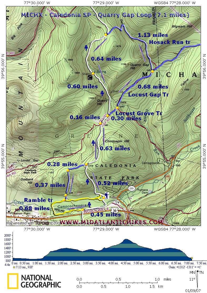
Description: Approximately 7.1 mile, moderate,
circuit hike using park trails and the AT to form a "figure
8". Total elevation gain of about 1200 feet .... 400 feet in
0.5 miles. Take lunch in cool and refreshing Dark Hollow
surrounded by Rhododendron Thickets, Hemlock trees and massive
rock formations.
Park in the second parking lot on the left after passing park office. Trailhead is at the rest rooms. Note the changes in signage noted in Erin's critique below. |
|
Get Printable/Downloadable Map! Zipped National Geographic. TOPO! GPS and Universal GPX Files |
Trail
Notes: The white blazes of the AT are on the
trees to the right of the rest rooms. Proceed south along the
AT, passing the yellow-blazed Ramble Trail on the right and
crossing a bridge over Conococheague
Creek.
Bear right and begin walking on the berm of the
old Rolling Mill Race. You will be surrounded by Hemlocks and
Rhododendron during this segment of the hike. US 30 will be to
your left.
At
0.45 miles the AT will turn left and cross the mill race on a
narrow bridge. Continue straight along the mill race on now
yellow-blazed Ramble
Trail.
Cross the old Mill
Ruins (probably the location of the water wheel). Descend
through a swampy area on boardwalks and re-cross Conococheague
Creek on another well-constructed
bridge. In another 0.68 miles, come to an intersection with an un-named blue-blazed trail. Turn left on this trail and soon cross a dirt road. Take a few steps to your left to regain the blue blazes. This is the beginning of the short but steep climb mentioned in the description. Climb to the top in 0.38 miles. An un-blazed trail comes in from your left. Turn right staying on the blue Trail.
The
AT will come in at an angle from your right in another 0.28 miles.
Continue straight on the white-blazed
AT. In 0.63 miles join Locust Grove Trail (a dirt road). Turn right. In a short distance (0.16 miles) the AT will turn left onto a footpath. This is part of your return route. (The segment you just walked between here and the last blue-blazed trail will be retraced on your return.). Continue straight down the hill. To your right is Quarry Gap Rd. Bear left, passing a yellow forest gate and crossing a stream filled in with gravel. |
|
You
will gradually ascend, passing some fenced in areas on either
side. These are deer management study areas to see how a
timbered area recovers without deer (They can't get in.) vs.
when deer are able to feed on the new growth (the area you're
walking through). Can you tell the
difference? Descend slightly. There will be a trail with blue blazes and a sign post sans sign on your left at about 0.68 miles from the forest gate (Hosack Run Trail). Turn left here, walking through a tunnel in the Rhododendron. (Note a drop in temperature.) Cross the stream. This is the best spot in the circuit for lunch.
After your break continue up the hollow,
re-crossing Hosack Run. Climb steeply via switchbacks to the
crest of the hill and a junction with the AT (white) at 1.13
miles from the last junction. Turn
left on the AT. Cross a stream and a rock field before coming
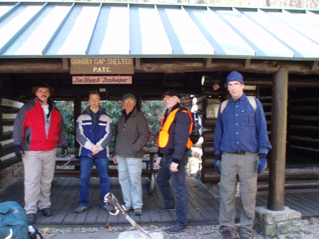
to the PATC Quarry Gap
shelter in another 0.64 miles. Proceed steeply for 0.60 miles and rejoin Locust Grove Trail (dirt road). Turn right and soon pick up the AT on your left. Follow it past the blue-blazed trail on your right that you came up on earlier. Descend steeply for another 0.5 miles to the park road. Turn left and follow it back to your cars. ______________________________________
______________________________________
Name: Erin Hike: Caledonia SP-Quarry Gap Date; 04/20/14 Rating: 2
Critique: If you like walking in the woods, this is a nice hike. However, it's not a very picturesque hike; we didn't even take out our camera's once. The unnamed blue trail mentioned at the beginning is now called the "3 Valley Trail." Locust Grove Trail is now marked as part of the Locust Gap Trail. The Hosack Run Trail is also marked on the sign post now in paint. There are no longer any deer enclosures (exclosures would be a better word). You'll notice rolled up fencing in a few spots. You'll also notice an abundance of young trees where the fencing would have been. My partner said at the end, "it'll be like we never did it." No views. Not very challenging. Meh. Not worth the 2.5 hour drive.
______________________________________
Name:
Justin
Hike: Caledonia State Park - Quarry Gap _____________________________________ Name:
Jim
Hike: Caledonia State Park - Quarry Gap ______________________________________ Name:
Patrick
Hike: Caledonia
State Park ______________________________________ |
|
|