Hike Schedule

Gear/Tips

Trip Archives

Flora & Fauna

Recent Critiques

Desk Tops

Hiking Links

Hall of Fame

Restaurants

Trail Blockage Report

  Contact Us  


                              Last Updated: 11/01/09  


                                                        Pennsylvania Hikes Virginia Hikes West Virginia Hikes Maryland Hikes

Welcome to a web site full of information on hiking in the Mid-Atlantic Region (PA, MD, VA and WV) ... topo maps, 3-D maps, elevation profiles, GPS data, directions, trail notes, photos.... everything you need to prepare for an excursion into the wilderness. Information for 202 hikes and over 2570 trail miles are now available. Venues such as, but not limited to, Shenandoah National Park/VA,  George Washington and Jefferson National Forests, VA and WV, the Monongahela National Forest in WV, state forests throughout PA, Green Ridge State Forest in MD and regional, state, county and federal parks throughout the Mid-Atlantic region are represented.


Please read the Terms of Use before using this website then click on the desired state on the map to the left to continue.


"Yet in the walks I take through nature in quest of truth and demonstration, I recognize a poetry in earth and sea and sky, ruled in their cycles of harmonious actions, deeper and more sublime than ever muse un- taught in science could inspire." William B. Rogers: First State Geologist of VA, First president of M.I.T. and namesake of Mt. Rogers, Va.

___________________________________________________


Latest Published Hikes

Douthat SP-Beards Mountain Figure Eight, VA

Douthat SP-Middle Mountain Loop, VA

Chuck Keiper Trail - West, PA

Circumnavigation of World's End State Park, PA

Ketchum Run - Scar Run Circuit, PA

___________________________________________________


Bulletin Board


Attention MD AT Hikers: The SHA has approved plans to construct a permanent parking lot on Weverton Road. Work will start on or around September 14 and last through November. It is not known at this time if the lot will be totally closed. The project will proceed faster if it is. Consider using Harpers Ferry or Gathland State Park for access to the AT in that area.

___________________________________________________

M. R. Hyker's Latest Adventure(s)


10/24-27/2009 – Douthat State Park, VA car camping and day hiking: Douthat (pronounced DOW-thut) State Park is the oldest State Park in the Old Dominion, constructed by the CCC in 1936. We’ve driven by the exit for it on I-64 many times on our way to and from the Cranberry Wilderness, Lake Sherwood and New River National River Park. We drove through the campgrounds once just to check them out about eight years ago than thought nothing about it. Then a friend sent me a set of Leonard Adkins’ “50 Hikes in …. VA”  books. One contained the descriptions of two hikes within the park. The same friend explored these hikes last year and rated them highly. This year I decided it was time for us to visit them. Since we had a long way to drive and would be camping there the decision was made to circumnavigate both Middle Mountain on the western slope of the valley and I guess what is called Beard’s Mountain on the eastern slope, adding about 4.4 miles and 900 feet Elevation Gain total to the combined hikes.

Janet, the dogs and myself were joined by Doc and the Mad Hatter on the first night. We reserved sites at the Lake Side loop. The night air was pretty chilly but the day time temps were in the 50s with mostly clear skies … great hiking weather. The next day we started the Middle Mountain Circuit from my campsite. I won’t enumerate the trails used here but there were several. The first 3.5 miles was an almost constant, but very gradual, 1700 foot climb on meticulously maintained trails. It hardly felt like we were putting out any major effort. The fall colors were about a week beyond prime but the yellows of the Beech and Poplar still contrasted nicely with the reds of the Maples and Oak, especially at the lower elevations. We passed a couple of “unofficial views" as we climbed upward. (One note here, almost all of the views in the park centers on the lake in the valley so you’ll see it quite a bit.) A series of switchbacks brought us to the first official overlook. After a brief photo op we ascended on yet more switchbacks almost to the ridge and followed a spur trail out to an old cabin at the Tuscarora Overlook and the grandest view of the day. From there the hike was literally all downhill or flat. We would have two short climbs down in the valley as we approached our campsites. The Tobacco House Trail provided one last view of the lake. The final 0.8 miles followed the west bank of the lake, offering several nice “reflective” moments.

We returned to find that Steve and Mary had joined the group. After dinner we built a nice fire and spent some time huddled around it before retiring for the night. The next morning found the temperature dipping below freezing for a bit, making it hard for me to crawl out from under my sleeping bag. I finally got up and immediately re-kindled the fire. After a hardy breakfast we all drove down to the
Visitor Center to begin the Beard’s Mountain figure 8 Loop. The hike started with hiking across the lawns of some park buildings to pick up the Wilson Creek Trail at an old chimney and followed it to the Buck Hollow Trail. From there we began a prolonged climb up the hollow. About halfway up we took a side trail to our first vista of the day. After the prerequisite photo op we returned to the main trail and proceeded up the hollow again. Just as it looked like the trail was going to become steeper we turned left onto the first of several switchbacks. At the apex of the figure 8 we took a nice break before finishing our first climb. Once again we had more nice switchbacks in front of us. Surprisingly, the next view was not on the top of the ridge but significantly below its crest. The wide side-hill trail was basically flat so we were back at the apex in no time. We took lunch and then began some more switchbacking, first down and then up as we traversed Beard’s Gap, passing yet another view of the park. At the top we captured our last view, this time looking into a valley to the east of the park … no lake this time! From there we followed the Brushy Hollow Trail back down to Wilson Creek, crossing it on a swinging bridge
. P-Hyker was a little apprehensive about this but she made it across while on lead. Once over we made a right turn and followed the multi-use Flat Run Trail for one mile back to our cars.

The last night was a repeat of the previous ones except a dense cloud cover moved in. This helped to keep the temperature relatively high. The next day we all broke camp at our leisure and headed home. First Janet and I headed to Vic’s in Clifton Forge to check out their breakfast buffet. Though the selections were somewhat limited the quality was very good and the waitress kept our coffee cups full, something you need for a 4.5 hour drive back to civilization.

Read More Adventures Here!


___________________________________________________


Latest Outing Critiques

Name: Jim Leo                                                                                            Hike: Otter Creek Backpack
Date: 10/25-26/09                                                                                                    Rating: 4

Critique: Mike, Thanks so much for providing the trail descriptions and waypoints. The GPS really does make wilderness hiking a more carefree adventure. Our trek was Mylius to Shavers, Green Mnt, Possession Camp, Otter Creek and back to Mylius. Camped at the intersection of Green Mnt. And Possession Camp, nice camps sites here. Dropped to the low 20's. First time for me in about 12 years and first time for my girlfriend. I would highly recommend not reading " A Walk in the Woods" (Bill Bryson) while out on the trail. She was up half the night scared out of her wits and of course everything was fine. It's a comedic but true slant on wilderness experiences. Possession Camp is the most beautiful trail, lots of Hemlock and rhododendron along most of the trail and little tributaries and springs along the way. The section of Otter Creek is equally beautiful. Some of the best camp sites are right along the the Otter creek trail just after the intersection of Possession Camp, Moore Run and Otter Creek. I hope she'll try it again. You're doing great work, Mike.

______________________________________________________________________________________________


Name: The Tick                                                                                                             Hike: Duncan Knob/ Strickler Knob
Date: 10/25/09                                                                                                           Rating: 4

Critique: This was a very nice hike. Started the hike at about 11:30 and headed up the Scothorn Trail which is more steep than is to be expected as soon as you get out of the car. After stretching the legs on the uphill for a few minutes, it became much easier. Got to the intersection of the Massanutten trail and took that to the intersection of the Strickler Knob trail and Massanutten trail. Went to Strickler Knob which was the highlight of the trip and well worth the 1.5 miles out to the knob and back. Spent some time out on the knob which was a lot of fun and not to be missed. Hiked over to Duncan knob next and climbed to the top for some great views. Could sit up on either of the two rocky outcroppings for a long time but it was getting late in the day. The trails between the rocks get a 3/4 rating but the rocks make this trip worth the effort. Would do again and I wonder how I missed this trail for so long.

______________________________________________________________________________________________


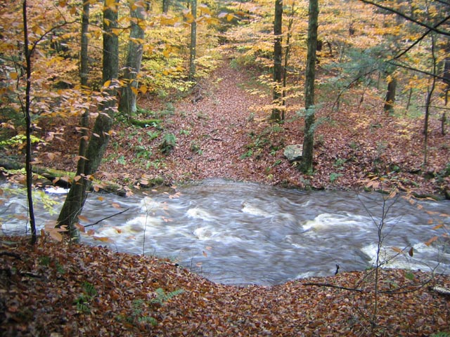
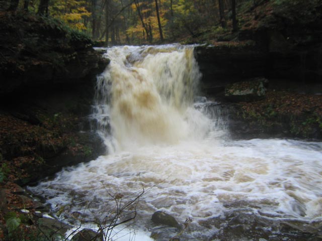
Chris H.                                                                                                                         Hike: Ketchum Run-Scar Run Circuit

10/24/2009                                                                                                                 Rating:


My buddy and I just did the Ketchum Run hike this weekend right after the rain had stopped. Those smaller streams turned into raging rivers. Compare the pictures that I send to you with the ones on your website. It was soggy and very awesome to see those raging rivers. Ketchum Run was unreal. The stream crossing after you make a left from the yellow-blue ski trail was basically impassable. We did the bushwhack there instead and eventually met up with the Loyalsock trail where it comes in from the left.

The pic of this stream crossing is the small drainage just before the 2 campsites before Lee's Falls. The red x trail that goes below Lee's falls was definitely impassable. We enjoyed the hike and I absolutely love your website. it is such a great resource for getting ideas of where to go for trips as that is the hardest part of getting a trip started.


Check out this movie file of Lees Falls gone wild.


______________________________________________________________________________________________


Name: Dave Barry                                                                                                       Hike: Roaring Plains Circuit
Date: 1010/09                                                                                                             Rating: 2

Critique: The Canyon Rim Trail could be a great experience. However, we missed a least three trail junctions (tee pee in particular) and were in a somewhat dangerous position for half a day because of it. The trip ended late with a trip leader with a wrenched knee and gashes on his face (from a fall) and two participants who would not try it again. The poor trail documentation and rugged terrain are a dangerous combination.

Big Suggestion for the all trail descriptions - give compass headings and distances. For instance, the instruction for finding the tee pee trail is something like "starts behind the campsite a short distance into the laurel thicket". A much more effective description would be something like "about 150 yards NW (300 degrees) of the fire ring". By the way the thicket is actually small pine trees.

We greatly appreciate the huge effort involved in MidAtlantic and the wonderful hikes it documents. The GPS tracks will be increasingly useful as more of us obtain that equipment.

______________________________________________________________________________________________

Name: Paul Fofonoff                                                                                                   Hike: Roaring Plains Circuit
Date: 10/10-11/2009                                                                                                Rating: 5

Critique: I led a trip to Roaring Plains for the DC Chapter of the Appalachian Mountain Club on Columbus Day Weekend. It turned out to be the most spectacular but also the most strenuous hiking that I've done in Mid-Atlantic region, comparable in roughness and dramatic views to some of the roughest trails in New England, and except in altitude, to some of the rougher trails in the West. We followed Mike's route up to the Tee Pee Trail, which we hunted for but could find no trace. We considered a bushwhack, but instead continued rockwhacking along the Canyon Rim, following the cairns through a seemingly endless boulder field. Throughout the route, we had to stop periodically to look for paths or cairns. We were lucky to have good weather for most of the trip, as clouds lifted on Saturday afternoon, but rocks and leaves remained slippery, especially on the Boars Nest Trail (the 'Sliding Board'). This is one of those trips where you tell yourself 'Never Again' the day after, and then start thinking about returning as the aches and scratches start to heal, when you look at memories and pictures. Mike, thanks, for getting us out there!

______________________________________________________________________________________________

View All Critiques