
| Allegheny Trail-South Shuttle Backpack |
|
|
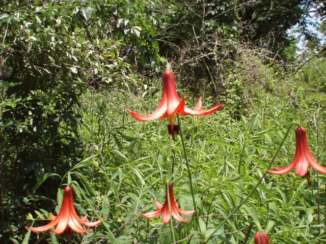
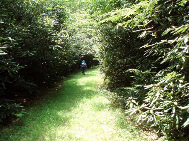
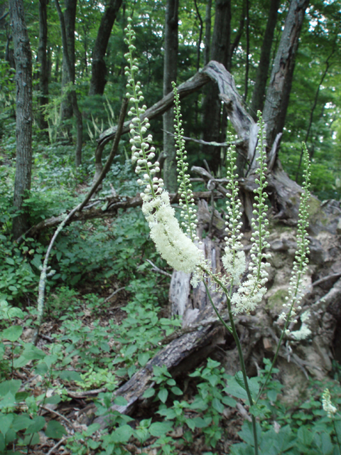
Description: The Allegheny Trail , when completed, will be a 330 mile linear trail stretching from the Mason-Dixon Line at Bruceton Mills, WV in the north to its intersection with the Appalachian Trail on Peters Mountain on the VA/WV border in the south. (Currently there is a thirty mile gap between I-64 and Laurel Run.) It is totally maintained by the West Virginia Scenic Trail Association (WVSTA). It is unique in that it utilizes both public and private lands. Such being the case, When hiking it remember to respect the rights of the private property owners and adhere to all sign postings. The �ALT�, as it is commonly referred to, traverses highland ridge tops, pretty stream valleys and open farmland. The forest diversity is unlimited. One moment you might be walking through a mature hardwood forest, maybe with an understory of chest high Black Cohosh, the next moment a dense Rhododendron tunnel, and then perhaps a farmer�s pasture. Also keep in mind that maintaining such a large project is difficult with waning volunteerism and funding. Expect some rough spots as you proceed. |
|
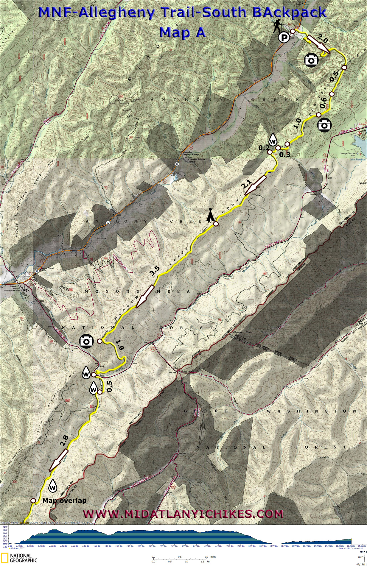
Described here is a 29 mile, 3 day, strenuous backpack along the southern section of the fully completed trail. Throughout its course you will gain over 5,000 feet in elevation. Near the beginning and the end water availability may be an issue so be prepared to carry extra, especially in the summer. �Camel up� whenever you can. The primary water source for the second night�s camp is a pond. While the water quality is good after filtering it is full of suspended sediment. To prevent rapid clogging of your filter pass the water through a bandana or some muslin first. The hike starts at the trail crossing on RT 92 at the Bear Branch parking lot and ends at the Jerrys Run Road trailhead just north of I-64. Use the following Google Maps Links to set up a shuttle or contact Tracy Asbury of Outdoors Adventures (www.wvoutdooradventures.com). He will shuttle you for a fee. Google Custom Directions to the South Trailhead Google Map Directions for Shuttle to the North Trailhead The ALT is part of the Great Eastern Trail (GET). ________________________________________ |
|
Zipped National Geographic TOPO! GPS and Universal GPS Files |
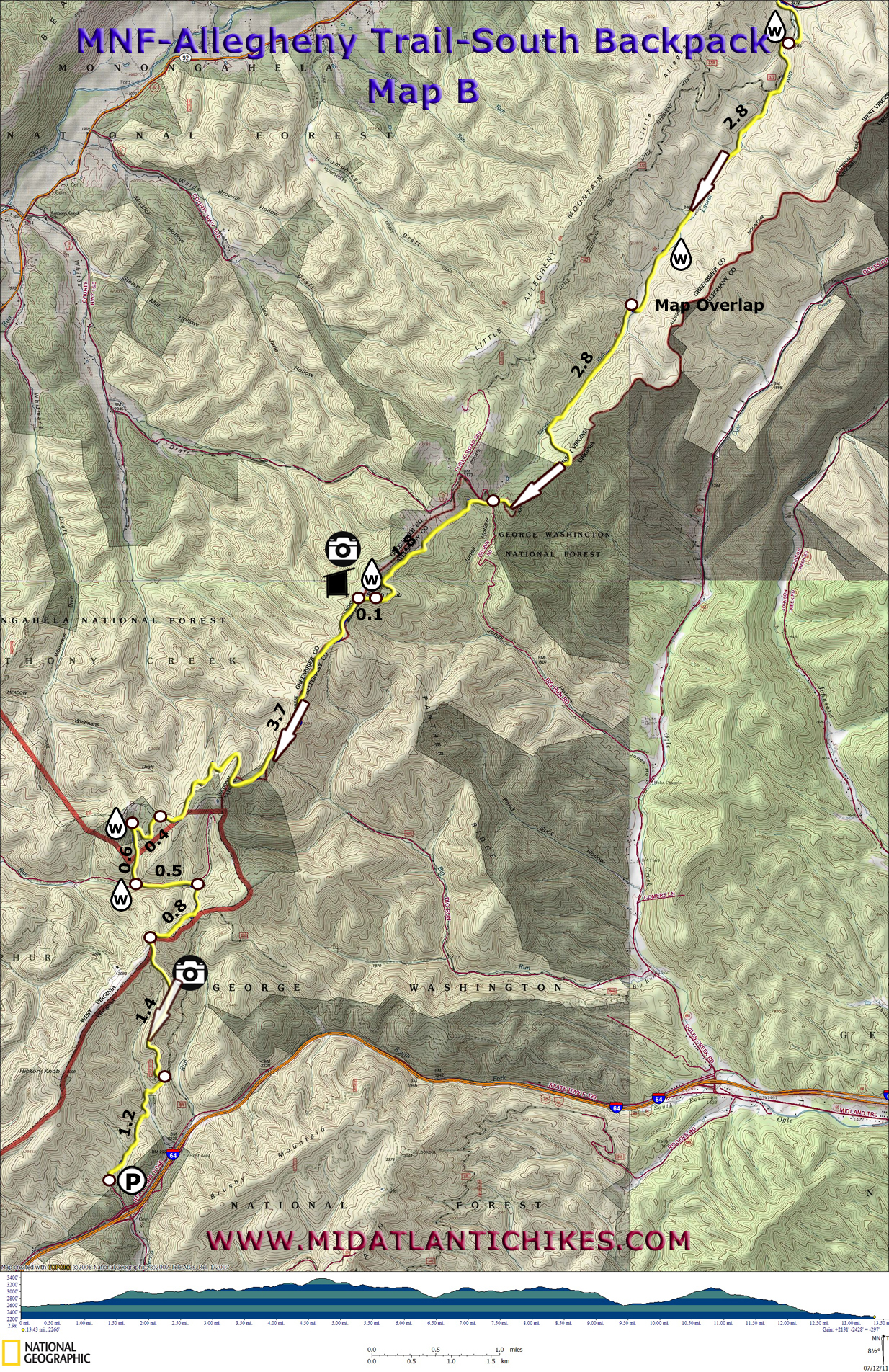
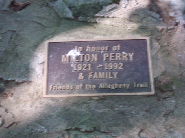
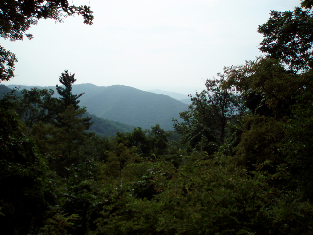
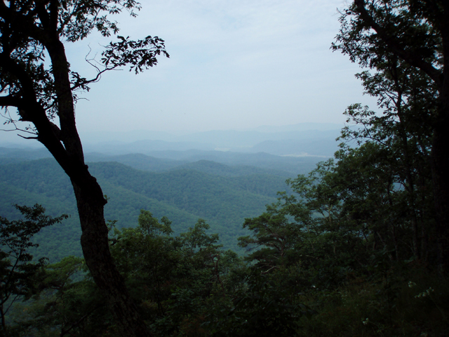
Trail Notes: The ALT is blazed with yellow paint rectangles. Day 1: Walk through the break in the split rail fence and cross Rt 92. You�ll pass through a couple of wildflower meadows before crossing Anthony Creek on a FS bridge. The trail might seem to suddenly end in a weedy opening. The trail is to the right, at about 2:00 o�clock. From here the trail is easy to follow as it switchbacks up the side of Meadow Creek Mountain, offering window-sized views of the mountains to the west and south, before merging in 2.0 miles with the Meadow Creek Mountain trail, a grassy jeep road. This trail leaves the ridge to the east in another 0.5 miles, descending to Lake Sherwood. Continue straight. In 0.6 miles there is a view of the lake to the left. In 1.0 mile the trail briefly leaves the jeep road, veering to the left and crosses a tower service road in another 0.3 miles. Soon cross Dilley Run. I recommend collecting enough water here to last you through the first few miles of tomorrow since this is the only water source on the ridge. In 0.2 miles the trail turns left to rejoin the jeep road. It is up to you how much farther you want to hike today. There are no established campsites but there are several flat and rock free areas to pitch a few tents. We camped 2.1 miles from rejoining the jeep trail. If you stop here you will have approximately 13 miles to hike tomorrow. Day 2: If you stopped where we did the night before continue south on the trail as it undulates up and down for 3.5 miles to a nice vista overlooking the gap between the mountain you are on and Little Allegheny Mountain. Here the trail turns sharply to the left and sidehills downward for 1.9 miles to Meadow Creek. After replening with water and taking a break, cross the creek on a bridge and then CO Rt 14. The trail turns left onto an old grade and soon passes through a parking lot. Pass the kiosk and bear right onto another road that passes through a hardwood forest. The trail then veers off onto a footpath encased in Rhododendron. In 0.5 miles from crossing CO Rt 14 cross Laurel Run on a FS bridge. Here you join a wide, grassy road but the Rhododendron display continues. Pay close attention to the blazes as the trail will leave and rejoin the road a few times. There are two or three meadows where the trail fades out but some easy exploration will soon regain the trail. Be particularly careful 2.9 miles after crossing the bridge. You�ll pass through one such meadow bearing to the right to regain a badly eroded road/part time stream. The road soon crosses the stream and continues straight. You might have a tendency to stay on it but it will actually take you back downstream. Right at the part time stream crossing make a sharp left hand turn to stay on trail. The base of the trail marker had eroded away but we propped it up the best we could with rocks. The trail crosses the run (much smaller now) several times before turning left and climbing out of the valley. You�ll pass a sign for the Eastern Continental Divide. (Water on the east slope flows to the Atlantic while water on the west slope flows to the Gulf of Mexico.) In 2.8 miles from the sharp left turn arrive at the Perry Family Memorial (These folks allowed the trail to be built across their land.) and then a private road. Cross it and climb steeply. The trail follows the fence of a pasture for a while before veering away. In 1.8 miles from the Perry Memorial reach a blue blazed spur trail on the right that leads to the previously mentioned pond. In another 0.1 miles arrive at the Graham Shelter on Smith Knob. The ground around the shelter is a bit rough but you should find suitable places for a few tents. Check out the view in the field in front of it. Day 3: Before you break camp make sure you have enough water to get you through the next 5 miles. Continue south on the ALT. The trail drops down into a bit of a saddle and then climbs, eventually joining an old woods road. At 3.7 miles from the shelter the trail turn left off of the road and descends for 0.4 miles to a more heavily used old road. You might find water here. Turn left and descend 0.6 miles to a road intersection and the confluence of two streams. This is the last viable water source. You are also on Westvaco property. They have also kindly allowed the use of their land for the trail. After stocking up with water turn left onto the woods road and follow it along the drainage for 0.5 miles. As the road approaches a gate the trail turns sharply onto another woods road at a trail marker and climbs another 0.8 miles to the day�s high point. From here the trail gently descends for 1.4 miles along a spine. Watch for more views near the top. A few short parts are overgrown with weeds, blueberries, or Mountain Laurel. The latter two can be wonderful in season (flowers and fruit) but all can be rough on a hiker�s legs. Thankfully these sections are short lived. |
|
Just as the trail approaches a gravel road it veers right back into the forest crossing a usually dry drainage and climbing ever so slightly through a shallow gap. You should be able to see homes through the trees. In 1.2 miles from the gravel road arrive at the Jerrys Run Road trailhead.
________________________________________
________________________________________ |
|
|


