| Bear Meadows-Indian Wells Loop |
|
|
Description: The Rothrock State Forest is named for the late Dr. Joseph Rothrock, a native of Mifflin County, who is recognized as the Father of Forestry in Pennsylvania. Through his guidance the state purchased thousands of acres of barren forest to protect them from future abuse. These lands eventually became Bald Eagle and Rothrock State Forests. What exists today was made possible by men and women like him. Located just south of State College the forest has become a retreat for students and teachers as well as local residents and distant adventurers like us. It supports a well maintained trail system as well as a portion of the Mid State Trail (MST) which runs from Greenridge SF, MD in the south to the New York Border above the PA Grand Canyon. Described here is a strenuous 13.3 mile day hike or overnight backpack trip. It features the ever popular Bear meadows, the Tom Thwaites Monument, Blueberries in season and vista after vista as you hike along the ridge of Greenlee Mt. It can be added to other hikes in the region that will be posted on this site for more mileage. Due to the steep hills and, in some areas rocky terrain, high top leather boots are recommended. |
|
Google Maps Custom Driving Directions The hike starts at the kiosk at the Bear meadows parking area on the road of the same name. The Mid Sate Trail is part of the Great Eastern Trail (GET). ________________________________________ |
Zipped National Geographic TOPO! GPS and Universal GPX Files |
Trail Notes: From the kiosk take the yellow blazed Bear meadows Trail to the left. Enjoy the views of the meadows as you will soon be surrounded by dense Rhododendron thickets and Hemlock trees. After a while more hardwoods will become mixed in with the forest. At 1.07 miles pass a junction with the Gettis Trail on the left. The two trails run concurrently until the Gettis trail leaves again on the left in another 0.25 miles. Cross a stream and enter a grassy area with a fire ring. (Note: Camping is not allowed in any Natural Area in PA.) The Sand Spring Path goes off to the left. Bear right to continue. In another 1.24 miles the trail ends on North (Bear) Meadows Road. Turn right. In 0.39 miles pass the Lonberger trailhead on the left. Turn onto it and begin a long gradual descent towards Galbraith Gap. In 0.75 miles cross the intersection with the Kettle trail. Shortly thereafter continue straight on an old woods road that comes in from the right. At 2.16 Miles from joining the woods road turn left onto the Spruce Gap trail but only for a few steps as you then turn right onto the Three Bridges Trail. Pass a small campsite and a piped spring before reaching Laurel Run Road. Immediately turn left onto the blue blazed Old Laurel Run Trail (The sign was missing when we were there but the trail was obvious.) Climb the rocky grade for 0.92 miles to Fire Tower Road. Turn left onto it and follow it for 0.54 miles to the tower and its restored cabin. This is a good break spot.
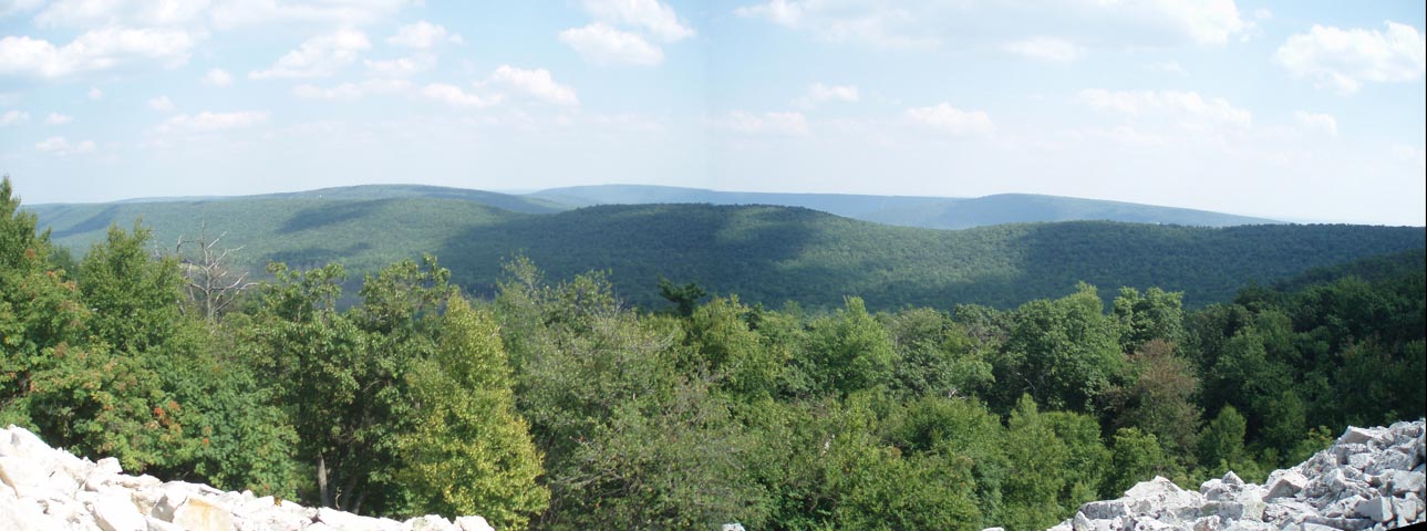
After resting turn right onto the orange blazed MST which is adjacent to the tower. If it is July and you like Blueberries the hiking will be slow along this stretch. If you also like vistas it will be even slower. In 0.37 miles pass the Tom Thwaites Monument on the right and the end of the Kettle Trail on the left. The next 2.20 miles feature all the Blueberries and Huckleberries you can eat, very rocky terrain and wonderful vista after vista, the final and best being the Indian Wells vista. You will pass a trail or two but stay on the MST. Shortly after Indian Wells arrive at an old charcoal flat that has been converted to a campsite. Continue on the MST for 0.67 miles as it descends passing two more smaller flats and a side trail to another piped spring. These are the last good potential camping spots. Cross North Bear Meadows Road and continue a steep descent on the MST. In 0.28 miles the MST makes a 90 degree right turn. Stay straight on the Gettis Trail that you passed earlier in the hike. In 0.37 miles find yourself on familiar ground as you arrive at the Bear Meadows Trail. Turn right and follow it back to your vehicle. |
|
________________________________________
________________________________________
Name: Loic &
Pascale
Hike: Bear Meadows-Indian Wells Loop ________________________________________
Name: Tom
O'Donnell
Hike: Bear Meadows-Indian Wells Loop ________________________________________ |
|
|