|
Black Forest Trail - South |
|
|
I'd like to thank Jeff Mitchell, Pat Roberts, Little Mountain Girl, Jon Wiborg, Lost Soul, Scott Adams and all the other BPers on the Midatlantichikes.com forums I've might have missed for their description of the trailhead, route and campsites we used. Their information made things a lot easier.
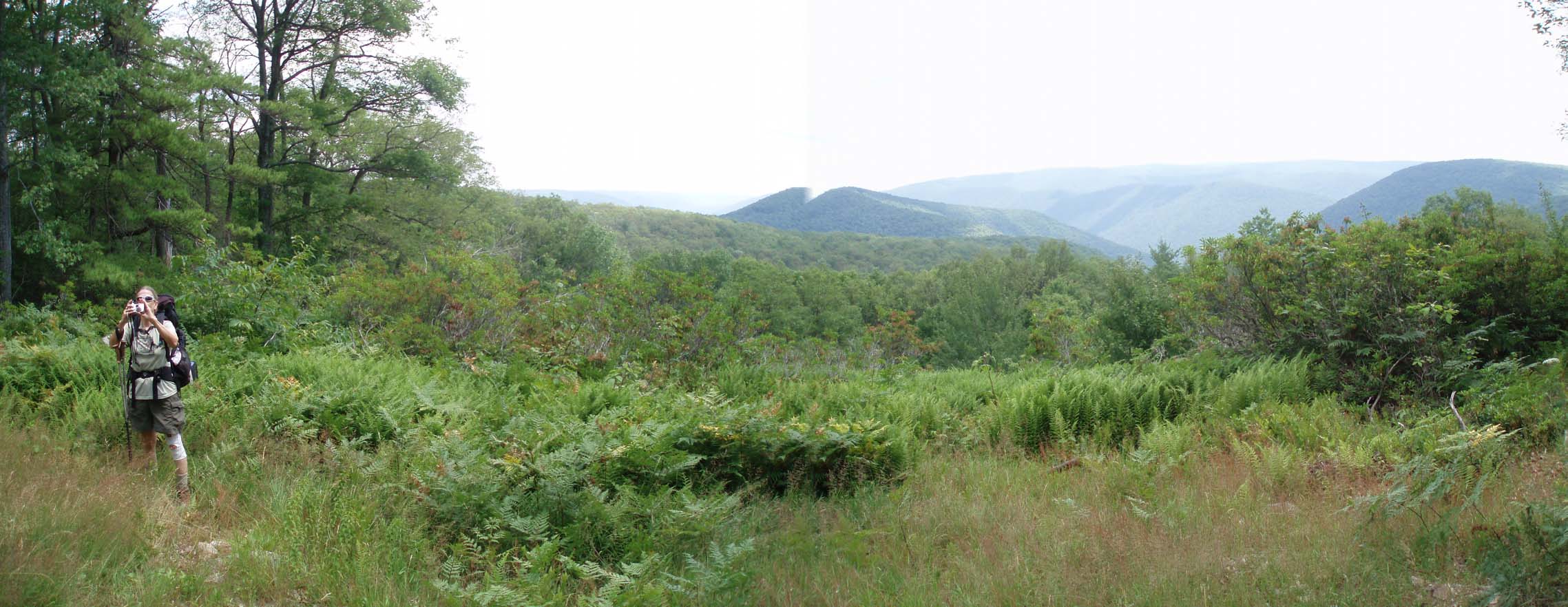
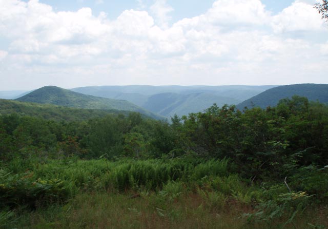
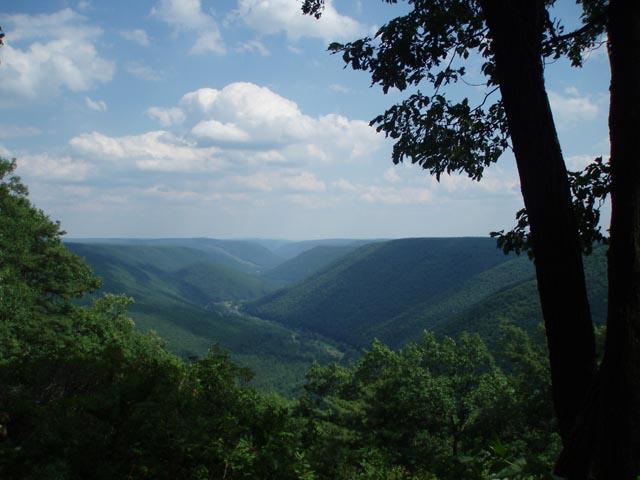
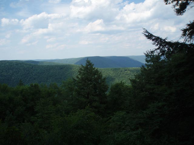
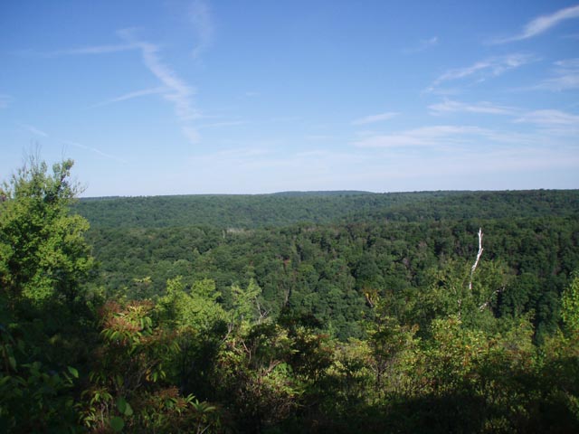
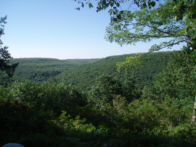
Description: The Black Forest in PA is a small part of the Tiadaghton State Forest. It is to PA what Dolly Sods is to WV, one of the prized gems of that state�s crown hiking jewels. The Black Forest Trail proper (BFT) is a 42 mile circuit that takes you through valleys and along ridge tops. It is interspersed with easy flat walks and rocky steep ascents and descents, some averaging 1100 feet elevation change in less than 0.7 miles. That�s steep! The hiker is rewarded by his/her effort with astounding views of the surrounding peaks and valleys and an assortment of forest types ranging from Pine Plantations, giant Hemlocks and Red Spruce to a mixture of Hardwoods and other deciduous trees. Wildlife you might encounter include, but is not limited to, turkey, grouse, deer, raccoon, porcupine, screech owls and black bear. |
|
As this description implies, it�s not necessary to hike the entire 42 mile circuit to enjoy the Black Forest. You can either setup a shuttle or use the many additional ski trails, forest trails and roads to form shorter loops. The following describes what I consider to be the southern section of the trail which is connected by the Pine Bog Trail, Blackberry Trail and less than 0.5 miles of forest road walking. Maps and details for the northern section, using the same cross connectors, can be found here. Look for the Trout Run Road sign on the right as you travel 12 miles north of Haneyville on PA Route 44. The parking lot is just a little further on the right side of the road. ________________________________________ |
|
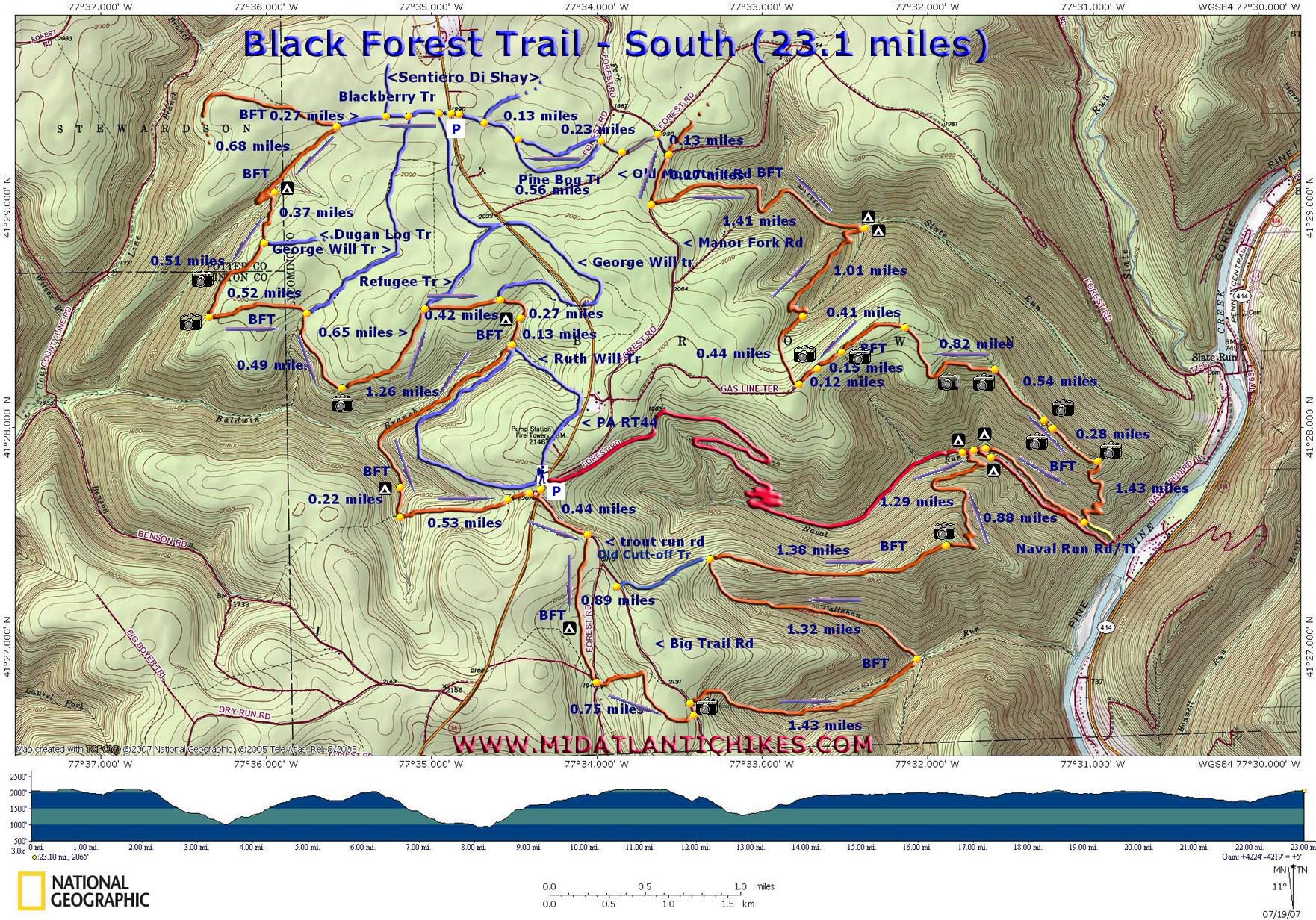
Printable/Downloadable Map (11X17 best) Zipped National Geographic. TOPO! GPS and Universal GPX Files GPS Text File for Non-TOPO! Users
|
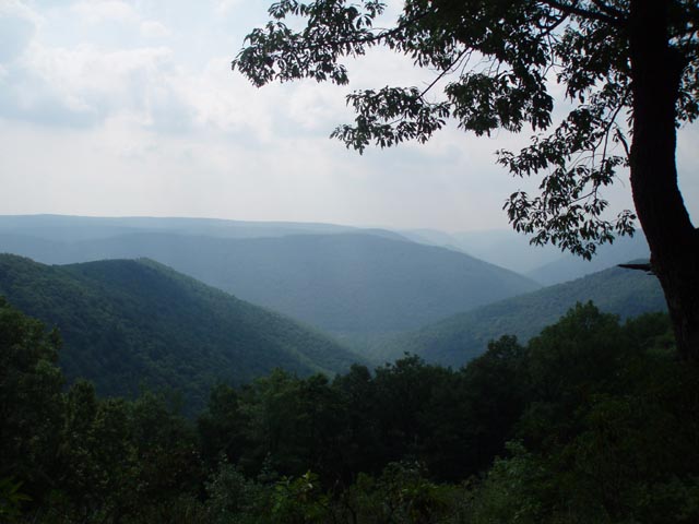
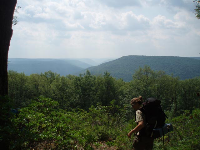
Trail Notes: The Black Forest Trail (BFT) is blazed orange for its entire length. Cross connectors are typically blazed blue. Other trails are blazed red. A few trails may not be blazed but these are not used here. Any trail shown on the map that is not used in the described route is drawn as an approximation and might not be shown in its entirety. These notes present this route as a 3 day/2 night affair. Feel free to adjust it to fit your time requirements. From the parking area walk south on a short dirt driveway that parallels PA Route 44 and turn left onto Trout Run Road. Immediately pickup orange blazes. In 0.44 miles from the parking lot turn right onto an orange blazed footpath. Before you do check out the vista that looks down the Naval Run drainage. You'll be camping somewhere down there tonight. For the next 0.89 miles the trail parallels Trout Run Road. As you begin a slight descent you'll pass a nice campsite and in a few yards cross the headwaters of Trout Run. It appears to be a pretty reliable water source. Arrive at the intersect of a gravel road on your right with Trout Run Road straight in front of you. Cross Trout Run Road and follow the edge of a lawn to pickup the trail behind a hunter's cabin. You'll climb gradually to a small plateau and in 0.75 miles from the Hunter's Cabin arrive at Big Trail Road. Here you'll find a nice view of the Callahan Run drainage as it meanders down to Pine Creek, as well as Hemlock mountain on the left. You'll traverse both of these before making camp. |
|
After taking in
this view turn left and walk up Big Trail Road a few yards
before turning right onto a footpath. Descend steeply before
picking up the south branch of the run where the grade moderates
significantly. 1.43 miles after leaving Big Trail Road arrive at
the confluence of the north fork of Callahan Run. Make a sharp
left here and follow this branch for 1.32 miles up to the ridge
line of Hemlock Mountain. If a bailout is needed at this point
turning left on the Old Cut-off Trail ( I don't think there is a
sign but it's pretty obvious.) will quickly return you to Big
Trail Road. Turn right onto Big Trail Road which will then merge
with Trout Run Road and return you to your car. To continue with the hike turn right at this junction and continue to follow the orange blazes. You'll dip down into a slight saddle before climbing steeply a short distance to the rocky summit of the mountain. (Be sure to turn around at this point and take in the view behind you. You'll be looking back towards your starting point. In a few more yards arrive at a grand view of Pine Creek and the surrounding mountains. You're almost to the first night's camp so if the weather allows take in the view for as long as you want. From the vista descend 1.29 miles to Naval Run and Naval Run Road (blazed red). Initially the descent will be steep but you'll pickup some nice switchbacks near the bottom. You can either turn left or right on Naval Run Road to find a nice campsite. There is a smaller one if you continue a little further on the BFT and cross the stream. The campsite to the left on Naval Run Road is just across the stream. The one downstream is pretty large and sits on a nice bench along the stream. During periods of high water there are several nice small falls, chutes and pools along the entire length of the stream. Notes: If, for some reason, you need to bail out and return to your car or you want to make this a short over-night trip continue up stream on Naval Run Road. It's visible on the map but not highlighted. It will climb the mountain through a series of gradual switchbacks. This, at one time, was a haul road for the loggers. It might be in rough condition in spots but is still passable. A more thorough description is given in Tom Thwaites "Fifty Hikes in Central Pennsylvania" in the Black Forest Trail Loop description. Do not follow his description all the way to the end. Stay on Naval Run Road to return to the parking area where your car is parked. If you have a real emergency continue downstream on Naval Run Road to get to the small town of Slate Run. Assuming that you are completing the route as described cross Naval Run on the BFT. the trail will climb a bit before turning downstream and following the run for 0.88 miles. It then makes a sharp left turn and climbs steeply up to the ridge line of an un-named mountain. (If you need to bail out before the climb the sidehill trail the BFT was on will continue for about 1/4 mile before arriving at Naval Run Road.) Near the top of the steep climb (1.43 miles after the start of the climb) there is a sign with a partial vista. Ass the grade lessens significantly you'll find a nice vista to the left of Naval Run and Hemlock Mountain and another to the right with a good view of Pine Creek and Little Slate Run. In 0.54 miles from the last vista arrive at a trail junction. Turn left to stay on the BFT. You'll soon pass another good vista to the left of Naval Run. There is a camera icon on the map. There is still a better one yet a few more yards further along also marked with a camera icon. I did not provide waypoints for either but you can't miss them. In 0.82 miles from the last trail junction turn left onto a dirt road. In 0.41 miles pass the Moss Hollow View on the left and then the White Birch View on the right. Soon after the last vista the trail turns off of the road to the right on a footpath. The continuation of the road is called the Gas Line Trail and serves as a bailout point to return pretty quickly to your cars. From here the trail begins a rocky descent along a dry tributary of Little Slate Run but abruptly turns left and climbs steeply to a smoother trail. This doesn't last long as the trail then descends at an even steeper rate. At one point you might wonder where the ladder is. After a few hundred yards of this you'll connect with some nice switchbacks that will take you to two of the nicest campsites on the entire BFT. Even on the brightest of days you are shaded in this dense Hemlock Hollow. I've not seen it but I've been told there is a mammoth specimen of same close by. There is a sign pointing to Pine Creek. This trail is Little Slate Run Tr. The official guide book for the BFT states that it cannot be used as a bailout trail because it crosses private property near its terminus. Continue to follow the orange blazes up Little Slate Run. It will soon climb high above the stream and moderate in pitch to a degree before reaching Manor Fork Road in 1.41 miles. Turn right onto Manor Fork Road. In about 0.3 miles The BFT will leave on the right at the intersection with Pine Hollow Road. This is where you leave the BFT to jump over to the eastern segment. Continue on Manor Fork Road a few more yards and turn left onto rather sandy Old Mountain Road. Follow it for about 0.23 miles. Here find a driveway to a hunter's cabin on the right. It is usually unoccupied in the summer. If it is occupied it is an easy open woods bushwhack around it on either side to arrive at a footpath in the rear of the cabin that crosses a stream on a small bridge. Follow this a short distance out to a blue blazed trail. This in the Pine Bog Tail. This section is a loop so turn either left or right will work as long as you follow the blazes. In about 0.56 miles you'll pass the other side of the loop on the left or right, depending on which way you turned onto the trail. Continue down the trail towards PA Route 44. In another 0.13 miles pass part of the Sentiero Di Shay Trail on the right. It's not signed at this junction but obvious. Soon turn left onto a driveway and pass a parking area on the left just before crossing PA Route 44. Cross the road and join wide and grassy Blackberry Trail. Soon after two segments of the George Wills Tr will come in from the left and another section of the Sentiero Di Shay ski trail will come in from the right. In 0.27 miles, after passing through an open area rejoin the orange blazed BF straight and to the left. Turn left. Soon pass through an open highland bog and the headwaters of the north fork of Baldwin Branch. Soon after re-entering the woods you'll join an old RR grade which will switchback down to the stream and a nice campsite. This site is big enough to hold 3 small tents but there is another one back in the woods that can perhaps hold 3 more. This is where day 2 ends. After breaking camp cross the stream and climb steeply to the edge of a plateau. From here you'll enjoy a nice view of the ridges to the west of the north fork of Baldwin Run and County Line Brach. In 0.27 miles from camp pass the junction with the Dugan Log Trail on the left. In another 0.51 miles arrive at another vista before turning to cross the Plateau. In another 0.52 mills the George Wills Trail will come in from the left on a grade. Stay on the BFT to the right and in 0.49 miles come to another vista on the right that looks over Baldwin Branch. After taking in the view continue along the grade. In 1.26 miles the Refugee Tr comes in from the left. Stay on the BFT. In another 0.42 miles yet another section of the George Wills Tr come in from the left. Continue on the BFT. descend into an evergreen hollow with a campsite on the right 0.27 miles from the last George Wills Tr junction. Follow the stream for 0.13 miles, pass to the left of the old stone pump house and climb to another grade. to the left is the Ruth Wills and Baldwin Gas Line trail is to the left. Turn right to follow the BFT. In 1.26 miles the trail will descend and cross a stream. There is a small campsite to the right after the crossing. Continue along another stream a short distance before making a hard left turn in another 0.22 miles. Climb steeply for the last time to reach the plateau. The last 0.5 miles is either a very gradual climb or flat through pretty open woods. Turn left onto a cabin driveway and in a couple hundred yards right onto a footpath before coming out onto PA Route 44. Your car is waiting for you on the other side. Printable/Downloadable Trail Notes ______________________________________
______________________________________
Name: Alice
______________________________________
Name: Dan
Hike: Black Forest Trail-Total
Date(s): 06/28-29/14
Rating: 5
Critique: Did the entire loop over 2 days.
Absolutely beautiful and I saw no over night backpackers
anywhere. Be prepared for a lot of ups and downs but they are
well worth it. The vistas, creeks, waterfalls are just
outstanding and I'll definitely be back to hike some of the
sections I really liked with my son. I had planned on a three
day hike but since I did 19 miles the first day and there were
possible storms Sunday night I figured I could do the last 24
miles Sunday. I paid for the 24 mile Sunday hike with sore quads
and hips that night. My recommendations for anyone doing this is
to go light and enjoy. No need for heavy boots and packs that
weigh 40+ lbs. I cowboy camped Saturday night under the stars
and listened to the bubbling brook for music. I would not do
this hike clockwise do to some of the ascents. Counter clockwise
is the way to go. Be alert for the wildlife. I almost got it
from
a rattle snake by not paying attention to what I was doing.
Go out and do this hike. Its a true gem of Pa and take Pictures!
______________________________________
Name: Adam
Hike: Black Forest Trail - South
______________________________________
Name: Chris
Hike: Black Forest Trail - South
______________________________________
Name: Tim Marshall
Hike: BFT (total loop - 42 miles)
______________________________________
Name: Garrett Socling
Hike: Black Forest Trail - Southern Loop
______________________________________
Name: Reid
Hike: BFT (total loop - 42 mile) ______________________________________
Name: Gerard Viau
Hike: Black Forest Trail - complete
______________________________________
Name: zach
Hike: Black Forest Trail North and South
______________________________________
Name: Bill
Hike: Black Forest South ______________________________________
Name: Jonny
Hike: Black Forest trail
______________________________________
|
|
|