|
Big Draft
Wilderness Shuttle 09/26/10 |
|
|
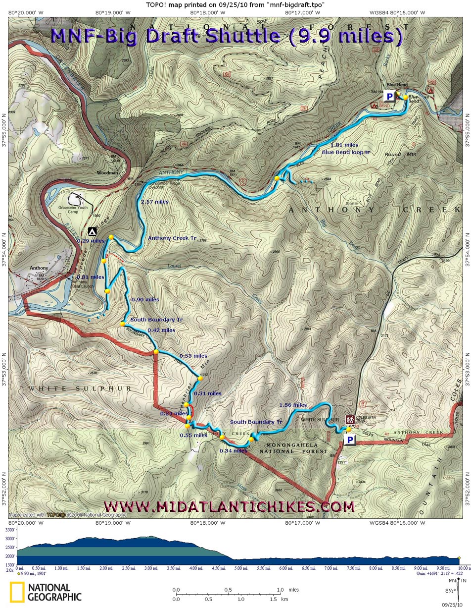
Description: The 5,144 acre Big Draft Wilderness is located on the Southern tip of the MNF, in the White Sulfur Ranger District. Until its designation as Wilderness in 2009 it was most prominently known for the excellent trout fishing in Anthony Creek and the exceptional swimming hole at the Blue bend Recreation Area. New hot showers and bathrooms have recently been added to the rustic campground. Described here is a moderate 9.9 mile shuttle using the seldom traveled South Boundary Trail, Anthony Creek Trail and a portion of the Blue Bend Loop Trail. A total elevation gain of 1700 feet will be accomplished. Most of this will be over the initial climb up the South Boundary Trail. Most of the remainder of the hike will utilize old jeep roads on the ridge tops and railroad grades along the creek. Additional mileage and elevation gain can be had by following the south section of the Blue Bend Loop Trail instead of the north section as described here. |
|
Turn off of RT16 into the Blue Bend Recreation Area. Turn left into the first parking lot to plant a vehicle for the end of the hike. The beginning of the hike will be 3.5 miles south on CO 13 (Big Draft Road), on the right side at a small pull in parking area. It is signed. ________________________________________ |
|
Zipped National Geographic TOPO! GPS and Universal GPS Files |
Trail Notes: From the parking area the South Boundary Trail immediately begins a climb to the top of Greenbrier Mountain. The trail will be blazed with blue diamonds. The climb moderates a bit after crossing an old jeep road. In 1.56 miles from the parking area the trail suddenly switchbacks to the right, making a steep but short surge to a high point. In a few steps join a grassy jeep road and descend slightly. In 0.34 miles the trail jogs right onto a footpath (Look for blue diamond blazes.) to avoid private property. The trail will become more obscure for a bit as it has become overgrown with Blue Berries and Mountain Laurel. Cross a part time stream and switchback up to another grassy jeep road (0.56 miles from leaving the last road.). Turn right here. Soon the road splits (an apparent reroute to avoid large boulders in the road.) The two reunite in 0.23 miles. In 0.31 miles turn left onto yet another unsigned jeep road. And descend gradually for 0.53 miles along the spine of a ridge to some forest (red blazes) and wilderness (Black and yellow stakes) boundary marker. Beyond this point most blazes have been removed or obliterated in keeping with the Wilderness designation. Continue straight on the road to its end in another 0.42 miles. The trail veers off to the right onto a sidehill footpath and plunges quickly down to its end at the signed Anthony Creek Trail. Turn right onto this old railroad grade but in 0.31 miles veer to the left on an unsigned but obvious footpath to another RR grade. (If you miss this turn you will find yourself hiking up the Laurel Creek drainage with a forest of giant Rhodos between you and the real trail.) Cross Laurel Creek and in 0.29 miles from leaving the last RR grade reach a beautiful campsite in a canyon-esque section of the valley. While the view of the creek will be blocked by thick Rhododendrons the path will get close enough to the creek to provide numerous views (and opportunities to make a few casts in seldom visited pools.) The next 2.57 miles are pretty straight forward hiking on the RR grade but there are a couple of places where it passes through some �benches� of open forest where the trail may become obscure. Look for cut logs from long ago trail maintenance and obliterated blazes (blue blazes either scrapped off or painted over with dark brown paint) to find your way. Cross Big Draft (May be a wade during periods of high water.) and turn left onto the Blue Bend loop Trail. In 1.81 miles cross a suspension bridge over the creek. Bear slight right onto a gravel path to reach the parking lot.
|
|
________________________________________
________________________________________ |
|
|