|
Billy Goat Trail - Sections C and B (Carderock) |
|
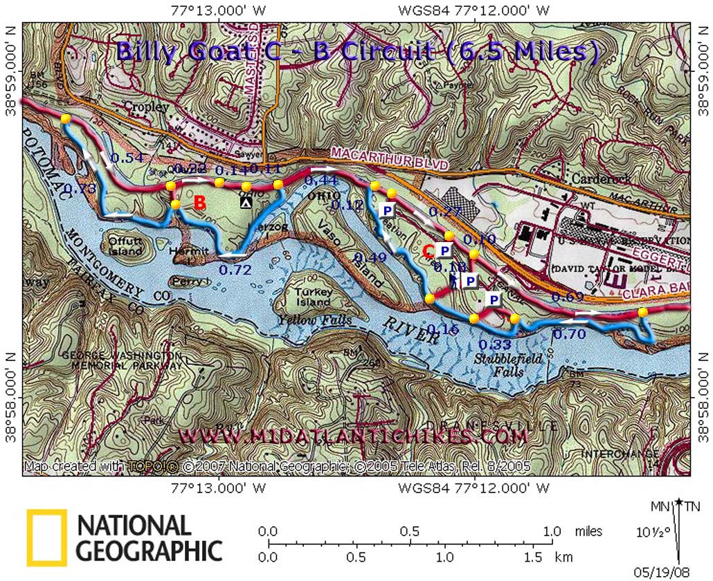
Description: The C&O Canal National Park draws hordes of visitors, the Great Falls area more so than the rest. By noon on a beautiful spring or summer day the Towpath will be clogged with sightseers, hikers, runners, baby strollers, fishermen and bicyclists. (Some of the latter can be quite uncourteous). The following 6.5 mile moderate �dumbbell� circuit seeks to avoid much of these issues. You will still have company on the Towpath but at much reduced numbers. The Billy Goat C and B sections are traveled nowhere near as much as the A section. Although the overall rating for this hike is �moderate� it is mostly easy, relatively flat walking. The increase in the rating comes from several little rock scrambles that have to be negotiated. Parts of the trail can be quite rocky and, after periods of heavy rain, other sections can be muddy. Good hiking boots are recommended for this hike. |
|
Unlike the A section, dogs are allowed on the C and B sections. Make sure he is trail worthy. He�ll have to do the same rock scrambles as you. This hike can be combined with either the Berma Road/Towpath Loop or the Billy Goat Section A Loop (No Dogs) for a 12 �14 mile trek. Start your hike early and enjoy it before things get really busy. Google Maps Custom Driving Directions Turn right at the "T" intersection then left into the first parking lot you come to. ________________________________________ |
|
Zipped National Geographic. TOPO! GPS and Universal GPX Files |
Trail Notes: From the parking lot cross the road and pick up a wide gravel trail. In 0.18 miles reach the canal towpath. Remember this junction because you�ll be coming back this way and will pass a couple of similar junctions that lead to different parking lots (but on the same park road). Turn right on the towpath and in 0.69 miles pass mile marker 10 and an old pivot bridge in the canal (Circa 1941). Turn right at the eastern terminus of the Billy Goat C Trail. Trees and rocks are blazed with light blue paint. There are several unsigned side trails along the route. Most of these go back to either the park road or one of the parking lots. In case you have to end the hike in a hurry we marked the three most obvious ones. The first is at 0.70 miles from the towpath (look for steps cut into the hill going up immediately after crossing a bridge.) The next is in another 0.33 miles. It goes to the same lot. In 0.16 miles you�ll pass the one that goes back to where you parked. The next one is in another 0.49 miles. This is a popular rock climbing area. Don't touch the ropes! It is marked with a kiosk and boardwalk and is at the western end of the park road. All along this route you will almost never be out of site of the Potomac. The trail will alternate between smooth dirt, rocky and some light rock scrambling. There are rock outcrops galore to explore especially as you approach the western end of Billy Goat section C. Continue on the section C beyond the above kiosk for another 0.12 miles before arriving at the western terminus of section C at the towpath. A part of the trail follows a rocky little stream and then crosses it. It might be hard to spot the continuation on the other side. Look for the blazes. |
|
Turn left on the towpath. You�ll repeat this section on the final leg of the hike. In 0.44 miles turn left at the eastern terminus of the Billy Goat Trail � section B. It is blazed the same way and follows much the same kind of terrain as section C. There is one rocky section that closely parallels the river. Take your time through this short section. In 0.72 miles come to a stream crossing. An obvious trail goes up to the right to the towpath but you want to cross the stream and continue to follow the blue blazes. Pass Offutt Island on the left. In 0.73 miles from the stream crossing arrive at the western terminus of section B and the towpath again. Turn right on the towpath. In 0.54 miles pass the shortcut trail you saw at the stream crossing. In another 0.32 miles pass the Marsden Tract day use area. In 0.14 miles more pass the Marsden Tract Group Campsite (by permit only) and in another 0.11 miles pass the eastern terminus of the section B. The next 0.44 miles is a retrace of what you hiked earlier. Over the next 0.33 miles you will pass a couple of footpaths that go back to parking lots just up from yours. In another 0.10 miles arrive at your turn off. Turn right and retrace your steps back to your vehicle. ________________________________________
________________________________________
Name: Matt
Hike: Billy goat c-b I parked at the first lot in the Carderock area; my garmin forerunner measured just under 6 miles round trip. I moved along at a decent pace, stopping occasionally for photos and it took about 1:45 to complete. As you head into the parking area you will drive through a tunnel; the multi-use trail that you want to start on runs above this tunnel. The hike itself is very easy- very little elevation and only brief instances of rocks to navigate- not really any sense of accomplishment.
________________________________________
Name: Daniel
Bachman
Hike: Billy Goat B and C ________________________________________
|
|
|