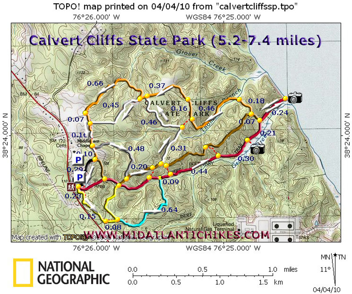
| Calvert Cliffs State Park Circuit |
| Description: Calvert Cliffs SP is a great place to take the family, complete with modern facilities, picnic areas, a fishing pond and extensive playground. While the bulk of the foot traffic on the busiest of spring and summer days is on the red blazed Cliffs Trail, as it follows the edge of Grays Creek Swamp to the orange Calvert Cliffs and shark tooth hunting (Bring a sand sifter if you want to try this out.) the equally well maintained peripheral trails are strangely under-utilized. Described here is a relatively easy 5.2 mile loop with an optional "inner loop" that can be added to up the mileage to 7.4 miles. Do one or both or put your own spin on it. There are several short spur trails (red dotted lines on the map) that will connect the trails and the service road (shown as brown on the map) to form your own circuit. |
|
________________________________________ |
|
Zipped National Geographic. TOPO! GPS and Universal GPX Files |
Trail Notes: This hike starts at the restrooms. All trails are blazed but not all trail junctions are signed. Keep a sharp eye out for turns.
Look for a yellow blaze among the pine trees to the left of the rest rooms. This is the Grays Creek Nature trail. In 0.23 miles arrive at a gas pipeline swath. Turn left onto it following its left edge for 0.15 miles and turn left onto a footpath. You will soon see the yellow blazes. In o.08 miles turn right onto the Blue Trail. In 0.64 miles cross Grays Creek on a small bridge and turn left onto the red blazed Cliffs trail. In 0.09 and then another 0.44 miles you will pass spur trails that lead to the service road. The first connects to the White trail. In another 0.30 miles pass the observation deck that is currently closed because of its unsafe condition. From here you can still get an impressive view of the swamp. In 0.21 miles arrive at a kiosk and the end of the service road. Continue for another 0.24 miles to the beach to view the cliffs and/or search for sharks' teeth.
Retrace your steps to the service road and bear right onto it. Climb a slight grade for 0.07 miles and turn right onto the Orange trail. Descend for 0.10 miles and cross the Thomas Branch Bog on the 150 foot boardwalk/bridge constructed by Eagle Scouts in 2001. Immediately after crossing the trail turns left and follows the bog upstream before turning away from it to climb a hill. In 0.46 miles from the bridge pass a spur trail on the left that leads to the White trail. In 0.16 miles turn left onto an old woods road. (This old road also continues to the right descending towards the junction of Thomas Branch and Grove Creek. Its condition is unknown at this time but might be worth a short adventure.) |
|
In another 0.37 miles the White Trail Will join from the left. In a few steps it will continue straight. You will do this later if you do the "inner loop" but for now turn right to stay on the Orange Trail. (It is easy to walk by this junction so keep an eye out for it.) Here you'll descend steeply into the headwaters of Grover Creek and climb out again. Fortunately both are very brief. In 0.66 miles from leaving the White Trail arrive at a wide grassy trail in front of a farmer's field. Turn left here and in 0.07 miles pass the western terminus of the White trail. In another 0.16 miles arrive at the junction of the Silver trail on the left. (The sign post was knocked down by a fallen tree as of this writing but should be re-installed soon. It is currently laying on the ground at the intersection). If doing the shorter route continue straight for another 0.10 miles and turn right onto the service road, shortly returning to the parking areas. Walk the park road back to your car.
If doing the "inner loop" turn left onto the Silver trail and in 0.48 miles arrive at the service road. Turn left onto it. In 0.20 miles pass a connector to the red Cliffs Trail on the right. Shortly after turn left onto the White Trail. In 0.31 miles cross Thomas Branch on a small bridge. Keep a sharp eye out for the continuation of the White Trail to the left. It is not marked at this junction. (A spur trail continues straight ahead to the Orange trail.) Turn left onto the continuation of the White trail and climb gradually for 0.46 miles and turn left onto the orange Trail. This should be familiar to you as you hiked it earlier. This time continue straight on the White Trail for 0.45 more miles arriving at the grassy wide road you walked earlier. Turn left onto it and follow the remaining above directions for the main loop to get back to your vehicle.
________________________________________
________________________________________ |
|
|