| Clear Creek Loop |
|
|
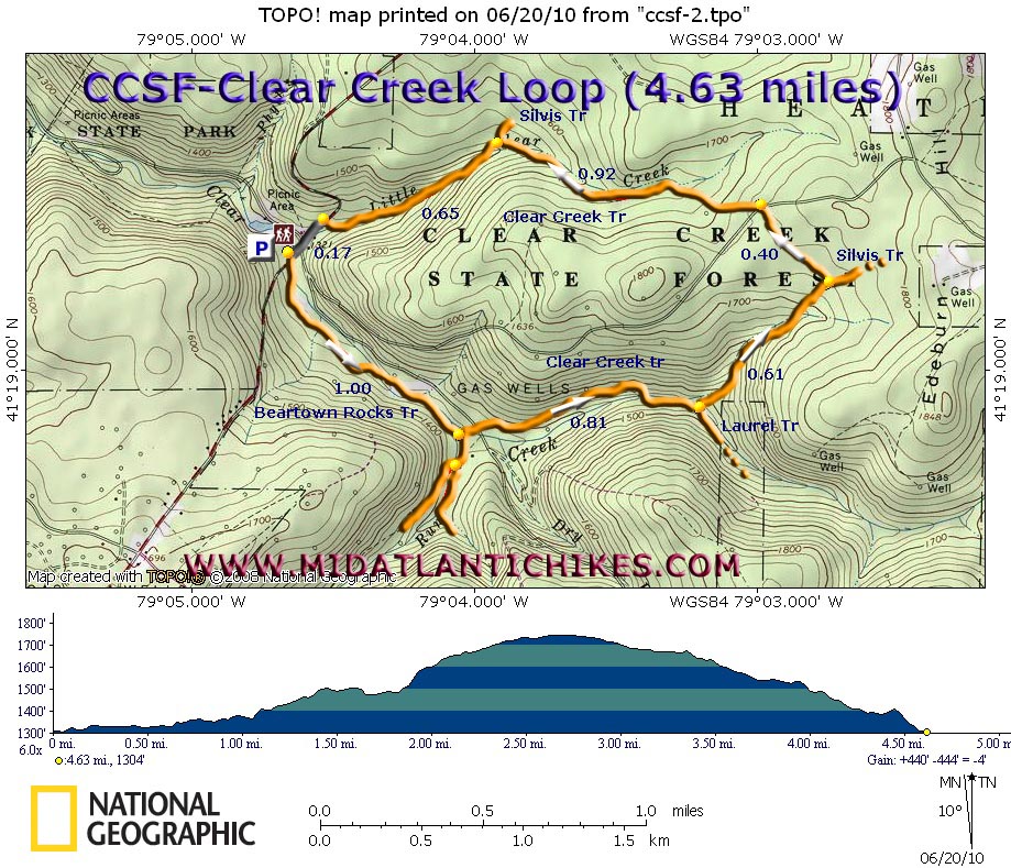
Description: Clear Creek State Forest, at around 13,000 acres, is probably one of the smallest state forests in PA. Despite this fact it hosts 34 miles of some of the nicest and best maintained trails in the state.
By the late 1800s the largest tract had been totally clear cut and in 1905 was burned over by a devastating forest fire. In 1933 the CCC planted Red Pine and Spruce which has not been harvested since. From 1905 to the 1960s the forest also supported an extensive oil drilling operation with one steam driven pumping station drawing from several wells.
Described here is an easy 4.63 mile loop utilizing the Beartown Rocks and Clear Creek trails. It can be combined with the Beartown Rocks hike also found on this site to create a nice 8 mile circuit.
Google Maps Custom Driving Directions
The hike starts in the Shelter 5 parking area of Clear Creek State Park on Rt 949. The first mile is a repeat of the beginning of the Beartown Rocks trek. |
|
________________________________________ |
Zipped National Geographic TOPO! GPS and Universal GPX Files |
Trail Notes: All trails are blazed with orange paint and trail junctions are signed.
From the parking lot cross the road and immediately join the orange blazed Beartown Rocks Trail. The first 1.0 mile is spent walking along the west bank of Clear Creek under a canopy of mature Spruce and Red Pine. At this point a bridge to the left crosses the creek with a spur trail leading to Corbett Road. Cross the bridge, turn left on the road for just a couple of steps and then right onto the signed Clear Creek Trail. In 0.81 miles the old road you�ve been walking on continues as the Laurel trail (I need to find out where it goes.). You want to turn left onto a footpath to stay on the Clear Creek Trail. The trail climbs gradually along a stream for 0.61 miles to the top of a plateau. Here cross a gravel gas line access road just before meeting the eastern terminus of the Silvis Trail. Make a hard left to stay on the Clear Creek Trail. In 0.40 miles turn left onto Clear Creek Road, pass a kiosk on the right and then turn right to continue on the trail. You will soon be following the drainage of Little Clear Creek. In 0.92 miles from the road the western terminus of the Silvis Trail comes in on the right.
Note: There is a sign that states that the trail will take you to Rt 949. This is not your parking lot.
Continue on the Clear Creek Trail for another 0.65 miles, arriving at Rt 949. Turn left and walk the shoulder for 0.17 miles back to your vehicle.
|
|
________________________________________
________________________________________
|
|
|