|
Soon pass Tumbling Rock
Shelter. In another 0.5 miles arrive at the junction of Birch Log
Tr. Turn right here. As you ascend Birch Log Tr ( blazed with blue
diamonds) pass a campsite on the right. Climb steadily for 2.1
miles. You'll gain about 1400 feet in elevation. This is the
steepest part of the trip.
Arrive at the junction of the
North/South Tr. As of this writing there is no sign but the trail is
obvious. Turn right and in about a mile turn left onto the Laurelly
Tr. Laurelly Tr starts as a footpath but shortly after passing a
small campsite on the right and crossing the run connects with a
railroad grade. Descend on the grade as it switchbacks to the valley
below and arrive at a ford and the junction of Middle Fork Tr at
3.23 miles from the last trail junction.
There are 3 options here. There
is a nice campsite to the left just after the ford. Camp there or
turn left and hike 1.5 miles downstream to the junction of Big
Beechy for some great camping or turn right (upstream) and hike 0.5
miles to good camping at the confluence of Hell For Certain Branch.
There are sites on both sides of the river here. If you opt not to
hike down to Big Beechy your trip will be 24 miles long.
Regardless of where you camp, to
complete the trip follow the Middle Fork Trail for
approximately 4 miles to the junction of the North Branch Tr. (This
trail may be defunct but the sign is still there.) Continue straight
on the Middle Fork Tr for another 2.3 miles. You'll pass a small
campsite on the right before turning north, away from the stream,
and finally reaching the North Fork Tr.
Turn right onto the North Fork
Tr and follow it back to the original junction with the North/South
Tr (1.14 miles). Turn left onto the North/South Tr and follow it
back to your car.
Printable/Downloadable Directions and Trail Notes
Critique this
outing!
______________________________________
______________________________________
Name: Garrick
Hike: Cranberry Wilderness BP 1
Date: 6/14-6/16 2012
Rating: 4.5
Critique: Did this hike on 6/14/2012 and followed the route as
listed in the trail notes. The weather was perfect for the three
days we hiked. Absolutely loved it! Navigation was no problem with
cairns and signs at every junction but thankfully no blazes. The
North Fork trial has some wash outs and there are a number of down
trees along the trail. Although some of the reroutes were tricky to
locate overall it wasn't bad. We found a great campsite with a
picnic table the first night between the two shelter houses along
the forest road. The aptly named Birch log trail was in good
condition although appears to be seldom used and the climb to the
ridge top is challenging without being sadistic. The Laurelly Branch
trail was soggy but otherwise nice. The Middle fork trail had some
down trees but was in the best condition overall and we made amazing
time hiking out on the third day. The wildlife was active as well;
saw a deer that about wandered into our first camp, spooked some
grouse, saw all kinds of fish in the river, butterflies, and a
member of our group even saw a bear between the Three Forks Trail
head and the waterfall campsite (great site btw).
We did run into two separate groups of hikers attempting the County
Line Trail to the north of this hike and both were forced to
bushwhack their way out due to the trail disappearing on them. One
group seemed a little frazzled by the experience so steer clear of
the Country Line trail if youre not prepared for some wilderness
navigation. Overall great this is a great hike!
______________________________________
Name: Barb Rodekohr
Hike: Cranberry Wilderness BP 1
Date: 4/14-16, 2012
Rating: 5
Critique: A group of six of us did this hike, following Mike's
directions. We had no real problems with navigation. The junctions
were signed and there are cairns at any confusing spots. In spite of
it being an ideal weekend in April, we saw only one other party of
backpackers, and a few bicyclists and fishermen on FR 76. That being
said, the trails are in pretty rough shape in spots, with lots of
blowdowns and berry canes blocking the way. If you want to hike on
autopilot, don't do this one! This was my first trip to Cranberry
Wilderness but won't be my last. It's a beautiful place, with
beautiful streams and great campsites. We even got to have ramps for
dinner.
______________________________________
Name: Boost Boy
Hike: Cranberry Wilderness Loop
Date: Nov. 4-6, 2011
Rating: 3
Critique: Hey folks. I planned and invited 8 backpackers to do this
listed 21+ mile loop, to include North Fork to FR102 to Birch Log
to North-South to Laurelly Branch to Middle Fork trails, and the
subsequent return to WV150.
We enjoyed the trip, HOWEVER, we could not complete the planned
route. Read on. I would NOT recommend this loop to anyone without
expert trail-finding skills, endurance-level athleticism, and a
perverse liking for the pain that results from carrying full packs
in VERY difficult terrain.
North Fork trail was easy to follow due to it's open nature, however
the trail is currently very overgrown, and includes numerous downed
trees, ankle-twisting erosion, and log obstacles. The main
switchback to the right was cairned and fairly easy to follow. The
two huge cut banks that occurred from flooding were another matter.
The first we circumvented by climbing up a 20-foot sandy chute (no
other choice) to find the trail. Luckily there were cairns up to the
left to regain the trail. The second one we descended down into and
went up the other side with careful climbing as well.
We camped just up the road on FR 102 along the river as a fisherman
was already ensconced in the North Fork Shelter. Because of the
difficulty of the hike day one, we voted and all decided to take a
shorter route back via Tumbling Rock trail to North-South trail day
two, and spend the last night in the Tea Creek Campground. Turned
out the climb up Tumbling Rock challenged the best of our
route-finding skills. Within the first 1/4 mile the trail goes right
at a small cairn. If you miss this and continue up a very steep old
overgrown forest road, you've gone too far. Later we lost the trail
and reconnoitered two additional times, thankfully finding cairns we
had passed after backtracking. Two crossings of the stream are
required to make the climb correctly. Very difficult terrain and a
very faint trail indeed. I have backpacked for 30 years and had a
heck of a time staying on the trail as leader all day. As faint a
trail as I have ever seen in places. Open forest compounded the
se issues at times.
After regaining the ridgeline, we turned right on the quite marginal
North-South trail and headed back 4.9 miles towards WV 150. This
trail climbed quite a bit at times (not much downhill at all), was
overgrown and extremely muddy in places. It also had numerous downed
trees and was just heinous overall. We lost the trail a couple more
times, particularly after 2 huge separate downed trees. Came out
just before dark. This 7.4 miles took us almost all day to hike out
of. Again, I enjoy difficult terrain, but this was extreme. Next
time I come, I will setup a base camp on the river and day-hike
these trails. Not for the faint of heart. Tea Creek Campground was
a blessing after the pounding we all took. My friends persevered
(many were expert hikers) but all said next time send the invite to
noreply@blistermail.com, ha,ha...-pd-
______________________________________
Name: Pat Campbell
Hike: Cranberry BP
Date: 7/8/11 - 7/10/11
Rating: 4
Critique: Arrived at the North Fork Trailhead on Friday afternoon
with rain coming down pretty heavy. Rather than starting the hike in
the rain, we killed some time, and a couple beers, in the parking
lot while we arranged our gear. By 3:00 PM the rain let up so we
started hiking. A couple hours later we were at the first trailside
campsite so we stopped there for the night. With a light rain
falling, we set up my Ray Way tarp that is big enough for my son and
myself. Uneventful evening and night.
Saturday morning we set off down the soggy, often overgrown trail.
The trail follows an old road so it isn't hard to follow except in
two spots. At one point it dead-ended into a tree. We had to climb
up the embankment on all fours to get around. Later, after the trail
crossed to the left side of the creek there is a section where the
side of the hill collapsed, taking the trail with it. It wasn't to
hard to just go downstream a ways, then bushwack up the hill to find
the trail again. After a few more hours of slogging through the muck
we arrived at the Cranberry River and claimed the North Fork shelter
for the night. While resting, 3 hikers from Cincinatti stopped to
chat and we had a good time comparing our similar experiences on the
trail.
That evening we walked up the road to check out the liming station
and had a black bear run across the road in front of us. Very cool.
The next morning we headed down the river to Tumbling Rock trail and
went up to the junction with the North South trail. Tumbling Rock
was nice, with a pretty good campsite about half way up. The North
South trail had a couple good climbs, but was otherwise and easy
hike. There are a couple good campsites along the way, but you have
to realize there is no water, and hanging a bear bad would be a
challenge with the type of trees that grow there.
I give this loop an A+ for wilderness experience and solitude, a C
for scenery( zero vistas, but great wildflowers and other foliage )
And a generous B for trail quality. It was lots of fun and I'm glad
to add it to my hiking scrapbook.
______________________________________
Name: Boost Boy
Hike: Cranberry Wilderness
Date: 2008
Rating: Oh 5 Definitely!
Critique: Excellent loop having done both this one described, as
well as other outings in the Glades. Just wanted to clear up the
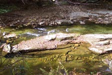
"orange" water. This is not due to acid rain, but is derived from
tannins leaching out from the reaction of various conifers with the
ground near steams. It looks like ice tea, but is quite clean.
Obviously not potable without filtration, but a natural phenomenon.
A pristine area for all to enjoy. Get out there! -pd-
______________________________________
Name: Bill Harvit
Hike: Cranberry Wilderness
Date: July 16, 2010
Rating: 4
Critique: First, let me say thank you very much to the person who
posted the description of the hike on this website. Quite frankly,
the description was as valuable as the map. Additionally, I would
caution anyone doing this hike to make sure they are proficient with
a compass or GPS. Many of the trails have no markings and even some
of the trail junctions are not marked.
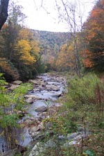
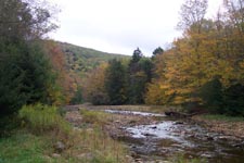
The plants and trees were magnificent! Some of the prettiest scenery
I have ever seen. I could spend an hour describing the beauty.
However, the trails are VERY ROUGH and we had to work hard to
complete the loop, which left little time for anything else. In
fact, we had taken telescopic fishing poles in hopes of fishing, but
simply did not have enough time.
Aside from seeing numerous bear tracks, we saw no wildlife
whatsoever. In fact, there were few birds. Moreover, I was surprised
that the streams were all a burnt orange color. What is going on? I
have heard of acid rain, but have not seen its affects until now. At
the risk of sounding political, I believe something must be done to
address the acid rain problem.
In any event, I would recommend this hike to anyone who is
experienced and wants the challenge of hiking in true wilderness.
Also, this hike would be much more enjoyable over a four day period
rather than a weekend.
______________________________________
Name: Jay
Hike: Cranberry Wilderness
Date: 09/03/09-09/07/09
Rating: 3.5
Critique: First, great site. Lots of good info here.
My 10 year old son and myself did the Cranberry Wilderness loop as
described here. Positives:If you like solitude, this is your hike.
We never saw another person EXCEPT at the shelter at the forks of
the rivers. Also saw workers coming into the Liming station but I
won't count them either. Saw signs of bear, heard a couple of birds
and rousted some grouse but that was it. Wildlife must not like it
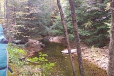
here either. There are some really nice camp sites along the trails.
Pretty easy hike all the way around. We really liked walking through
the pine areas with moss- covered rocks and vegetation everywhere.
Seemed surreal at times. Negatives: Trail maintenance is awful. But
that's why most of us hike, is the challenge. There was a lot of
overgrowth, wading through waist- high weeds, trees, etc. Some of
the trails needed cleared as some places were difficult to get
around, especially when we were going downhill. And if you were not
experienced in back- country trails, there were several areas where
it be easy to get lost. Blazes would be a very good idea.
Reasoning for the
3.5 rating is maintenance and markings. I try to look at this is if
I was going to recommend it to people. My 10 year old is a strong
hiker and he even complained at times. On the other hand, I loved
the solitude and am not sure I want more people coming here. Former
mountaineer living in NC now. Coming here brings back a lot of
memories. Will be back for the other hike soon enough.
M.R.Hyker Note: Read the government
definition of "Wilderness"
here.
______________________________________
Name: Jim Kirk
Hike: Cranberry Wilderness BP (Modified)
Date: 7/06
Rating: 5
Critique: It had been nearly 20 years since I had hiked this.
North Fork had changed a LOT. Even more than after the 85 floods.
The liming station was a shock too.
Tumbling Rock was a chore in July especially since it was wet and a
lot of trees were down near the top but it's probably the prettiest
part of the hike. The place where the trail crosses the creek is
super pretty and serene.
Started in the afternoon and camped maybe a mile above the liming
station. Camped at Hell for Certain the next night and then walked
out the next morning on Middle Fork.
Is there anyplace as pretty as Cranberry in the morning? The
sunlight cutting thru the mist and trees.
______________________________________
Name: WVwanderer
Hike:
Cranberry Wilderness Backpack
Date: 05/27/06 to 05/29/06
Rating: 5
Critique: Hey Mike. My critique can be found on my Blog at
http://wvwilderness.blogspot.com/ It
was a great hike! Thanks for posting it!
______________________________________
Name: Ron & Heather Eshleman Hike:
Cranberry Wilderness
Date: August 22-24th
Rating: 4
Critique: This backpack was our first trip to the Cranberry
Wilderness and we were not disappointed. The trailhead was easy to
find along the beautiful & secluded Highway 150 near Richwood, WV.
We were not looking for anything too strenuous and although this is
a long backpack of 27 miles, it is a gentle grade. The camping was
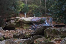
excellent and what a great surprise on day 2 to find a waterfall at
Big Beechy Run with great camping. We were somewhat perplexed
however, at the lack of wildlife...we saw no evidence of black bear,
we saw no deer at all, and we did not even see a squirrel or
chipmunk during the entire 3 days although we did see some grouse.
This trip was planned spur of the moment so thank you to
MidAtlanticHikes for the great maps and information!
______________________________________ |


