
|
Devil's Marbleyard/Gunter Ridge Loop |
|
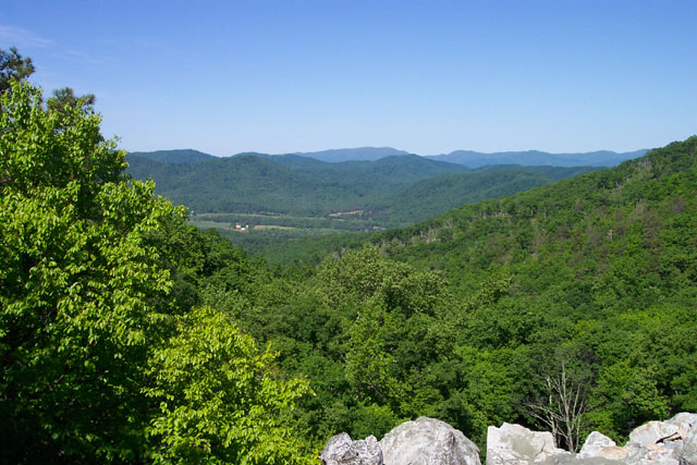
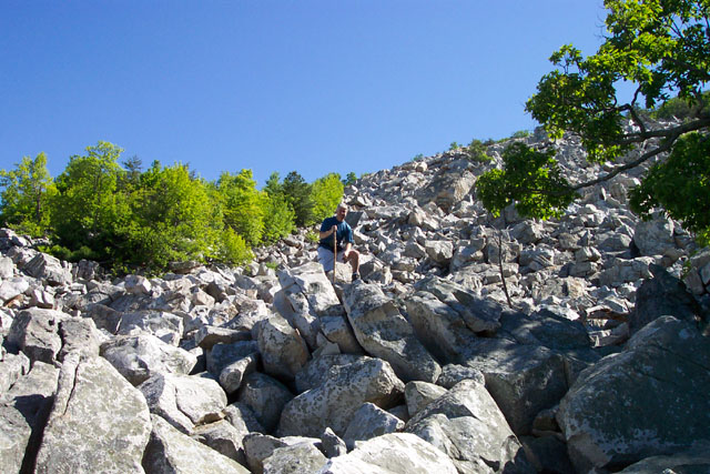
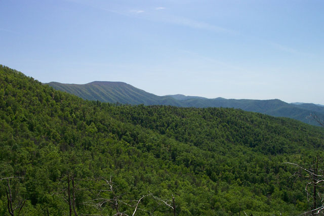
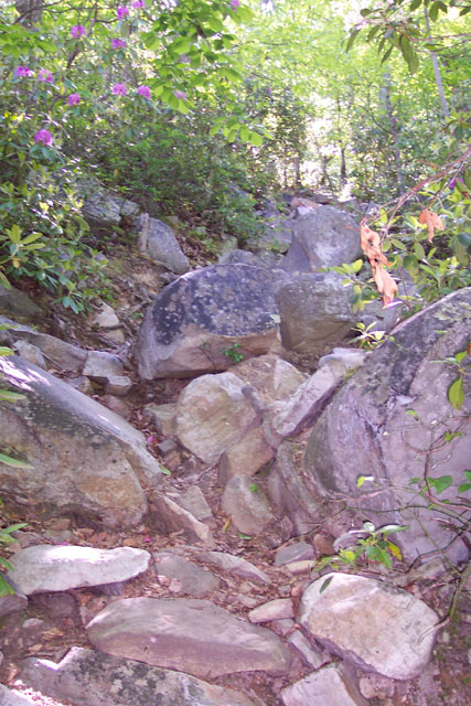
Description: This is fairly challenging circuit in the James River Face Wilderness of the Jefferson National Forest. The base route uses the Belfast, Gunter Ridge and Glenwood Horse trails to form an 8.3 mile loop. The climb up Belfast Tr is extremely steep and rocky at times but a visit to the Devil's Marbleyard will truly make it memorable. The trek along Gunter Ridge is mostly flat until the descent but there are a lot of blowdowns and some sections are quite weedy. Once one reaches the south-western ridge the reason becomes obvious. In 2003 almost every tree in the area was destroyed by a devastating forest fire. As a result of this destruction you'll be able to get long ranging views to the north and south of the ridge. You'll descend along 14 switchbacks (My friend Tony counted them.) to join a wide Glenwood Horse Tr which you'll follow in and out of short coves and up and over slight hills back to the starting point.
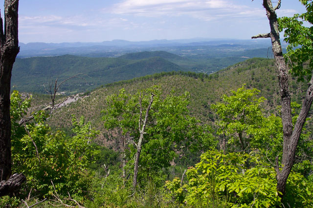
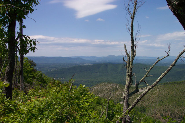
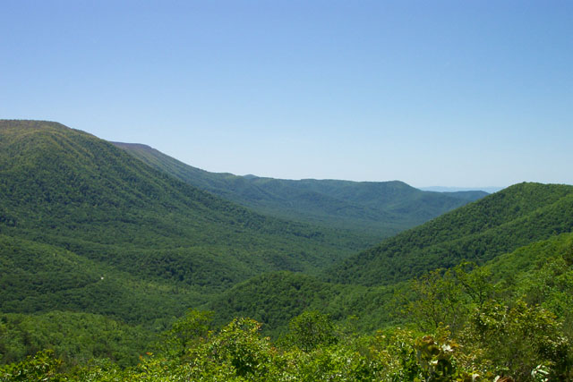
To add a little more distance and even more great views I recommend adding a 3 mile out-and-back along the remainder of the Belfast Tr and the AT. Views from the "Helicopter Landing Pad" will make the extra mileage worth every bit of effort.
The Belfast trailhead and footbridge is on the east side of the road and clearly signed. |
|
________________________________________ |
Zipped National Geographic. TOPO! GPS and Universal GPX Files |
Trail Notes: From the Belfast trailhead immediately cross a fork of Elk Creek on a footbridge and pass between two columns of a now defunct Powhatan Boy Scout camp. Follow the blue blazes. Shortly cross the junction with orange blazed Glenwood Horse Tr (GHT). (This will be your return route.) In a few yards come to the junction with an old woods road and a campsite straight ahead. Turn left onto the woods road and pass the old foundations of some camp buildings on the left. Soon cross Belfast Creek. The GHT will come in sharply from the left for a few yards before turning left at a sign. Stay straight on the Belfast Tr. As you enter the James Face Wilderness the blue blazes will cease but the trail remains obvious. You'll get glimpses of the boulder field know as the Devil's Marbleyard at about a mile from the trailhead but access becomes easier at about 1.3 miles. If you wish to explore " the Yard" remember where you entered at. As you climb up the boulder field the ability to rejoin the Belfast Tr becomes increasingly difficult. Continue up the Belfast Tr. In another 0.98 miles reach the junction of the Gunter Ridge Tr on the left. *** To add the out and back to the "Helicopter Landing Pad" continue another 0.39 miles to the terminus of the Belfast Tr at the AT (left and right). Bear right onto the AT south. You'll gradually descend to a saddle and then climb back up to another ridge line. Along the way you'll get partial views of the Blue Ridge. Suddenly you'll come to a wide open area with no |
|
trees in front of or behind you. This is 1.12 miles from the Belfast Tr junction. From this vantage point you can see east and south for great distances. Do an about face and climb through the brush to the top of the Ridge. This is the helicopter Landing Pad. It actually sits on Sulphur Spring Trail. If you have problems finding your way up proceed along the AT a little further and keep and eye out for a trail that comes in sharply from the left and is blocked with a small blowdown. This route will also get you to the top. Once at the top not only do you get a better view south and east you can now get views of the Shenandoah Valley to the west and look north to the valley through which the James River flows. Retrace your steps to the junction of the Belfast Tr and the Gunter Tr. *** If you prefer not to do the out-and-back turn left onto the Gunter Tr. If returning from the out-and-back turn right onto the Gunter Tr. For the most part the trail is not blazed. I think I saw two and they were quite old. Still the trail is easy to follow, even with the overgrowth and blowdowns. Initially you'll descend into a little hollow before observing views to the north. Here you will begin to see the ravages of the 2003 forest fire. As you reach the crest of the ridge you'll get views both to the north and south. Descend through 14 switchbacks to a horse fence and then a James River Face Wilderness sign. After this sign the trail makes a sharp left turn and soon crosses Little Hellgate Creek. In 3.37 miles from the last trail junction arrive at a wide gravel road. This is your return route, the GHT. Turn left onto the GHT. Initially it is not signed or blazed. Blazes seem to be reserved for trail junctions. In 0.96 miles the road splits. Follow the double yellow blazes to the right. In another 0.3 miles another inconsequential road comes in sharply from the left. It's not shown on the map. Continue straight a bit further. At 0.36 miles from the last blaze make a sharp left onto another road. The direction is marked with a diamond blaze containing an arrow. At 0.73 miles from the last turn arrive at the junction with the Belfast Tr. Turn right. In a few yards the trail splits with the Belfast trail going left and the GHT going right. You can either follow the Belfast Tr back to your car or take the GHT to where it meets up again with the Belfast trail again. You will then turn right and return to your car.
Printable/Downloadable Directions and Trail Notes ________________________________________
________________________________________
Name: Matt Alford
Hike: AT-- Matt's Creek to Devils Marbleyard ________________________________________
Name: Cliff
Hike: Devil's Marbleyard/Gunter Ridge Loop ________________________________________
Name: Clarkus
Hike: Devil's Marbleyard/Gunter Ridge Loop ________________________________________
Name: Tony
Hike:
Devil's Marbleyard/Gunter Ridge Loop ________________________________________ |
|
|


