|
Dolly Sods Circumnavigation |
|
|
Description: This is a moderate to slightly strenuous 22.8 mile backpack (add 2.6 miles if you do the pack-less out and back to the Lion�s Head) that will have you exploring nearly every thing that is �The Sods�. You�ll start at Dolly Sods North and traverse the Bear Rocks Trail followed by Raven Ridge Trail and then Rocky Ridge. Take in the vistas at Rocky Knob, Harman Knob and the Timberline Ski Resort overlooks before descending along Big Stonecoal Run to camp for the night. The next day consider the optional visit to the Lion�s Head before descending to Red Creek via Dunkenbarger and Little Stonecoal Trails. You�ll then traverse all but one mile of the Red Creek Trail, fording it twice, before camping at �The Forks�, the most popular campsite in the venue, and rightly so. On the third day you�ll use the remainder of the Red Creek Tr, Blackbird Knob Tr and Upper Red Creek Tr to re-enter DSN. Finish the hike by taking in the wonderful bogs along Dobbin Grade before retracing your steps back to the car using Bear Rocks Tr. Believe me, it doesn�t get any better than this! Notes: There are some wet spots, especially along Dunkenbarger Trail and Dobbin Grade so have some dry footwear waiting for you back at the car. |
|
Also remember that mountain top weather can change with a wink of an eye and in many instances you might be totally exposed to the elements so pack accordingly. As you reach the top of the mountain the large trees will disappear and the road will make a final sharp left-hand turn. Park here on either side of the road. The Bear Rocks trailhead is about 100 yards further down the road. There is limited parking there but these spots are often full.________________________________________ |
|
Large Map (Download before printing) Zipped National Geographic. TOPO! GPS and Universal GPX Files |
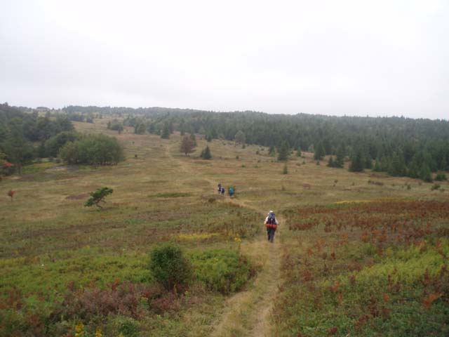
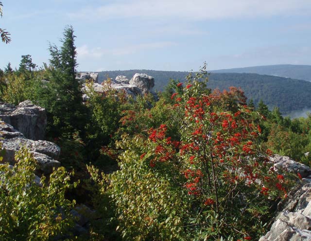
Trail Notes: There are no blazes in either Dolly Sods North or Dolly Sods Wilderness. Most of the trail junctions are signed in DSN but signs seem to come and go in the Wilderness area. Day 1: From the cars walk south on FR75 for about 100 yards and turn right onto an old jeep trail named Bear Rocks Trail (Tr522) and blocked by boulders. You will gradually descend to Dobbin Grade, passing a seriously eroded section of the jeep trail (A footpath to the left gets you around this.) and a mini-bog sheltered in a hollow. You�ll climb out of the hollow and descend to Dobbin Grade (TR526) at 1.02 miles from the forest road. The jeep trail is also badly eroded here. There are optional trails on either side. Cross Dobbin Grade and descend further through a grassy area to Red Creek. There are a few good campsites here. Cross the creek. Climb to the first rise. You�ll end up on an old ATV trail. Do not take the ATV trail but turn right onto a footpath at the USFS �Trail� marker. As you enter the woods you�ll pass through a small wet area. Cross a drainage and immediately turn right (uphill). Follow the drainage for about 15 yards and turn left. Walk through the woods until you pick up another trail that goes uphill. Turn right. Soon you�ll arrive at the grassy slopes of Raven Ridge although, at this point, you are still on Bear Rocks Trail. Follow the Trail stakes for another 0.4 miles until you arrive at the junction of Raven Ridge Trail (Tr521). Turn right here. It may be possible at certain spots to climb to the northern edge of the ridge for views of Dobbin Slashing and distant ridges. At about 0.17 miles from the last trail junction pass Beaver View Trail (Tr523) on the left. Soon reach a large grove of mature Red Spruce to your left (South). As you look at it there is a lone deciduous tree to its left, possibly a fruit tree. This approximates an opening in the grove and the front door of a fantastic but dry campsite protected from the elements. |
|
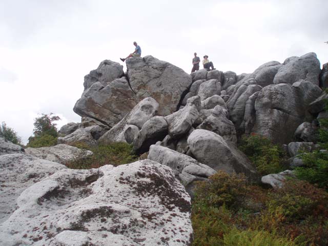
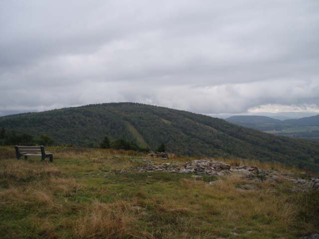
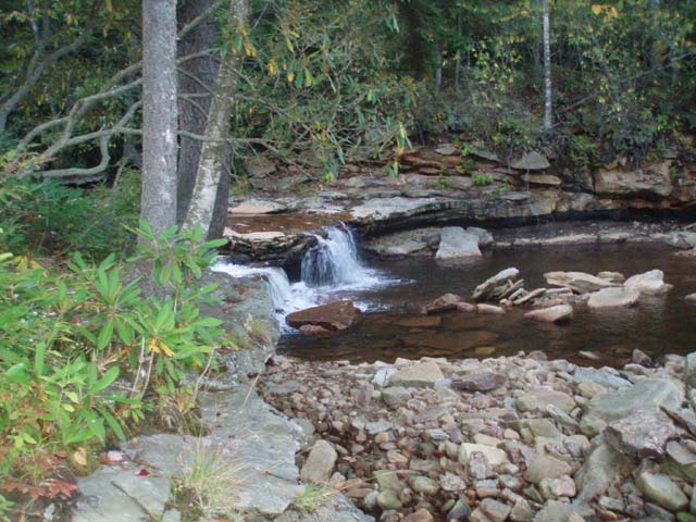
Continue west passing an unsigned trail on the left that eventually connects with Beaver View Trail that you passed earlier. At 0.86 miles from the Spruce Grove turn left onto a footpath cut through some small Red Spruce. In another 0.44 miles arrive at Rocky Ridge Trail (Tr524). Turn left here. From this ridge you can get sweeping views of Dolly Sods and much of what you just hiked. Continue south on Rocky Ridge Trail. At about 1.08 miles the trail veers slightly to the right and crosses Rocky Knob. Weather permitting this is a great lunch spot with views of Canaan Valley and Mountain. You have to rely on several cairns and short patches of footpath to get through this area. In about 0.3 miles from Rocky Knob you�ll pass a trail intersection in a wet area with a large boulder. The trail to the left is marked with cairns and leads to a dead end and a possible small emergency campsite should a backpacker need to get off of the ridge. By-pass this trail, pass another dry campsite, and in 0.2 miles arrive at a jeep trail. This is the junction with Dobbin Grade Trail (Tr526). Turn right to stay on Rocky Ridge Trail. Climb up a wide woods road to Harmon Knob in 0.44 miles. The actual knob is marked by a very tall cairn. The viewpoint is across a large rock field along the edge of the ridge. In about 0.2 miles arrive at an obvious footpath marked by a cairn on the right. You have two options here. You can either continue straight until Rocky Ridge Tr meets Blackbird Knob Tr, which comes in sharply from the left or turn right here to visit the Timberline Vistas. There is a huge boulder a couple 100 yards to the right as you look over the Canaan Valley and the Ski slopes are to the left. Just before you reach a bench at the Ski Slope viewing area turn left onto another spur trail that takes you back out to Rocky Ridge Tr. Turn right here and follow an old eroded jeep trail until you merge with the above mentioned Blackbird Knob Tr in another 0.33 miles. In 0.25 miles arrive at a large gray kiosk. Breathed Mt Tr in on the left side of it and Big Stonecoal Tr is on the right. Head down Big Stone Coal Trail. WARNING: right at the edge of the woods there is a sink hole. Stay on the logs or circle this area. If you step in it you will find yourself in mud up to your knees!!! Continue downhill, at times walking in a stream. Soon you will be walking on a railroad grade with Big Stone Coal Run coming in from the left and a tributary coming in from the right. At about 0.97 miles from the trail junction with Breathed Mt Trail you will pass a campsite on the left. In another 0.14 miles ford Big Stonecoal Run. There are 2 more campsites right after the ford on the left. The trail then veers east, away from the run and travels roughly along the edge between bogs and grand Pine plantations. These are popular camping spots but I think the closest water source is the run you just crossed. The trail will then turn south for a short distance. Before reaching the southern most edge of the plantation the trail will jog left and uphill through the plantation. A faint trail continuing south (to the right) here will take you out to yet one more great view of highland meadows with a backdrop of mountains. Stay straight on the main trail uphill to continue. The trail will go east for just a little bit before turning south and then bending westward again. Cross to the west bank of Big Stone Coal at about 1 mile from the previous crossing and head down stream to the junction with Dunkenbarger Trail. Perhaps the greatest campsite in the area is immediately to your left in a splendid stand of Spruce. This supposedly used to be an old lumber camp. FIRST ONE TO THE BEACH ON BIG STONE COAL GETS TO CAMP THERE!!!! Day 2: Side Trip to the Lion�s Head: From the campsite, sans packs but with cameras, snacks and water in hand, travel downstream on Big Stonecoal Trail. Visit the waterfall on your right. In 0.56 miles or so Big Stonecoal trail will veer to the right and downhill at the junction with Rocky Point Trail. You want to go straight on Rocky Point Trail, crossing through a rocky area marked by cairns and a very small part-time stream that crosses the trail. At 0.58 miles from the last trail junction and about 5 minutes from the small stream, look for a large cairn on your left. There is a labyrinth of trails here. All will eventually get you to the top but the best one is to the right. You�ll have to step up onto the rocks from the trail. Watch out for the crevices and snakes as you explore the area. On the eastern edge of the rocks you�ll find cairns that will lead you down through a large fissure in the rocks and reconnect you to the unofficial trail. Follow it back down to Rocky Point Tr and retrace your steps back to the junction of Big Stonecoal and Dunkenbarger Trails.
Head southwest on Dunkenbarger Trail. Be prepared for a lot of mud, roots and rocks, especially on this side of the hill. In about 0.75 miles come to Dunkenbarger Run and a great campsite along the run. There is more camping on the other side and to the left, a short distance down stream. Cross Dunkenbarger Run, turn upstream a few steps and then left to regain the trail. More camping is available to the right of the trail in a meadow. Just before the crest of the hill, on the left, is another great camping spot under 2 of the oldest Hemlock trees in the forest. Water is back at the run.
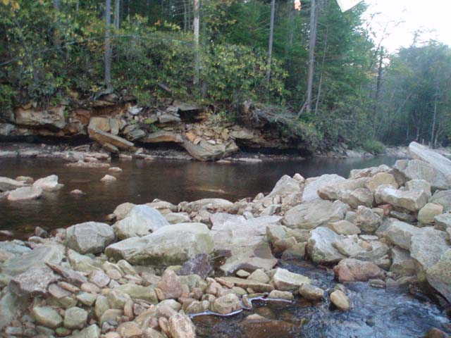
In approximately 0.8 miles from the Dunkenbarger crossing reach the junction with Little Stone Coal Trail. Turn left and descend rapidly along Little Stone Coal Trail as you get glimpses of the waterfalls to your right. Bushwhack to some of them at your own risk and enjoyment. A really big one is about 1/3 of the way down. In about 1.4 miles reach Red Creek. You�ll see a beach on the opposite side. The continuation of Little Stonecoal Tr is a few yards downstream from this beach. Make the ford and follow the trail out to the junction with Red Creek Tr in an open grassy area. Turn left onto Red Creek Tr and proceed upstream, first along a railroad grade and then climbing gradually up a very rocky footpath. At about 0.91 miles from the junction with Little Stonecoal Trail you will come to a cairn and a trail that goes to the left. This trail ends at a campsite. Continue straight on the main trail. Beyond this point to the left will be a sketchy, trail marked with a cairn on the downhill side that descends through the Rhododendron. The trail is hard to find and steep but is a quick connection with Big Stonecoal Trail and the rest of Red Creek Trail. This is a popular campsite. Shortly after your descent turn upstream (right) at the trail junction sign. You will join an old railroad grade for a while then bear to the right onto a footpath that will climb up above the creek. In 1.5 miles reach the junction of Fisher Spring Run Tr on the right. Descend to Red Creek. (There are campsites upstream from here on an old railroad grade.) The best fording area is usually near a broken tree trunk in a slight opening on the bank. The point to reach on the other side is near a couple of big boulders on a sandy beach. Cross the creek and turn right onto the continuation of Red Creek Trail. Initially the climb will be slight. You�ll pass a couple of nice campsites on the right before the grade intensifies. At 0.69 miles come to the junction of Rocky Point Tr. Cross it and continue to climb steeply for about another 100 yards before reaching another railroad grade. Turn right onto the grade. In 1.36 miles pass the junction of Breathed Mt Tr on the left and in another 0.2 miles reach �The Forks�, your destination for the night. There is good camping on both sides of the Left Fork. Day 3: After enjoying �The Forks� continue up Red Creek Tr. It will follow the Left Fork for a while before climbing steeply out of the drainage. The trail passes through open meadow, deciduous forest and spruce thickets before arriving at the junction of Blackbird Knob Tr in 1.26 miles. Turn right onto Black Bird Knob Trail. In 0.31 miles turn left onto Upper Red Creek Trail (Tr509) and follow it up, over and down an open grassy hill to the junction of Dobbin Grade Trail (Tr526). Turn right onto Dobbin Grade Tr. This is an old railroad grade that was used to haul lumber in days gone by. Being an RR grade the climb out of the bog is very gradual with several muddy areas along the way. Soon after making the last turn you�ll pass the signed southern terminus of Raven Ridge Trail on the left. Continue on Dobbin Grade. Cross the right fork of Red Creek and immediately turn left to stay on the trail. If you stay on the road that goes up to a wind whipped tree you�ll turn around to enjoy a fantastic view of DSN. If you walk up to the vista, return to Red Creek and continue up Dobbin Grade. At about 1.08 miles from the crossing pass Beaver Dam Trail (Tr520) on the right. This trail takes you out to FR75. In another 0.62 miles reach the junction with the Bear Rocks Trail. Turn right here and retrace your initial steps back to the cars. Printable/Downloadable Directions and Trail Notes ______________________________________
______________________________________
Name: Ed D. Outing Critique: The Dolly Sods has nice over night camping sites for backpackers. You will need to make sure to follow the trail notes, as there are no trail makers. There are trail signs at intersections. There are enough people hiking the trail that you should be able to follow tracks. We ran into a deer (eight feet away), which was not afraid of people. The trails were wet and had multiple stream crossings. The mud is at times up to you ankles. This was one of the muddiest hikes we have completed. The trails were cleared. Our gators that go up to our knees were covered in mud the both days we hiked. ______________________________________
Name: Mothman
Hike: Dolly Sods Circumnavigation ______________________________________
Name: Moonshine
Hike: Dolly Sods Circumnavigation ______________________________________
Name: Dave
Eccleston
Hike: Dolly Sods Circumnavigation ______________________________________
Name: Gregory
St. Clair
Hike: Dolly Sods Circumnavigation ______________________________________
Name: Rich
Hike: Dolly Sods Circumnavigation ______________________________________
Name: Kate
Hike: Dolly Sods Circumnavigation ______________________________________
Name: Kyle
Henson
Hike: Dolly Sods Circumnavigation ______________________________________ |
|
|