
|
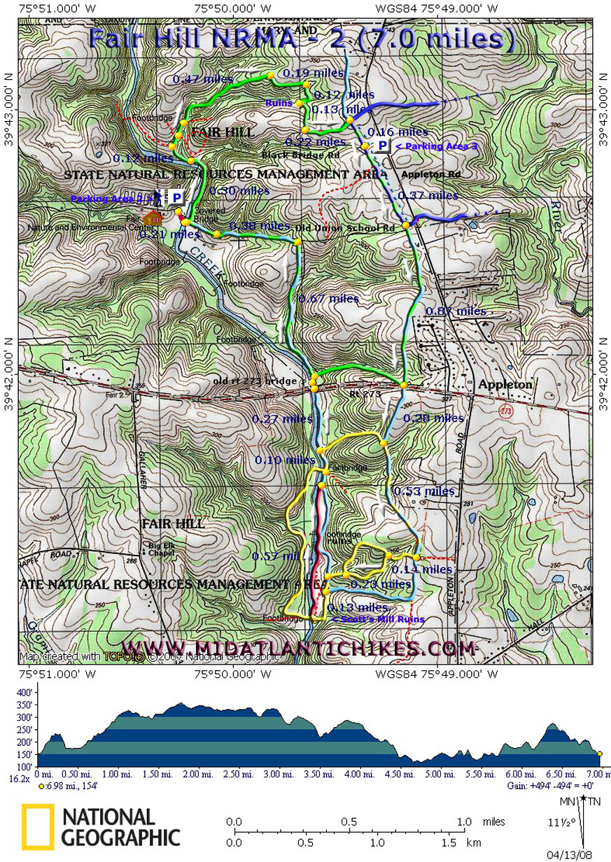
Fair Hill NRMA-2 04/12/2008 |
|
|
Description:
The Fair Hill Natural Resources Management Area (NRMA) is
located in the northeast corner of Cecil County, a mere stone�s
throw away from PA and DE. It consists of 5,613 acres (3000
acres of mature woods and the rest open pastures) and over 75
miles of multi-purpose (hiking, biking and equestrian) roads and
trails to explore. It was previously owned by William DuPont,
Jr. To learn more about the NRMA go to
their site. There are five blazed loops ranging from three to almost six miles in length (depending on where you start/end) but many of these can be spliced together, either directly or by using un-blazed trails and roads, to form loops of up to 12 miles in length. Described here is a relatively easy 7 mile loop using parts of the Green, Blue and Yellow trails shown on the park map. Portions of the Blue Diamond trail are used as connectors between the Green and Yellow segments. |
|
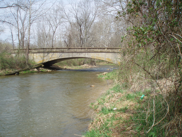
Approximately 1.5 miles of the middle of the trek is across open, relatively flat fields and is exposed to the sun. Wear sun protection and a hat if doing this hike in the summer. To counter-balance the boredom that might be associated with this section a nice walk along Big Elk Creek on an un-blazed but obvious fisherman's trail is added. (We've never seen so many spring-blooming Marsh Marigolds in one place before.) The trails are well marked for the most part. The terrain is considered to be "rolling". For a longer 11 mile figure-8 hike combine this one with the Orange Loop. Google Custom Driving Directions The hike starts at Parking Lot 2 and kiosk prior to crossing the Fox Catcher Covered Bridge. There is a $3.00 in-state parking fee paid on the honor system. The close-by Nature Center is open Monday through Saturday. ________________________________________ |
|
Zipped National Geographic GPS and Universal GPX Files GPS Text Files for Non-TOPO! Users
|
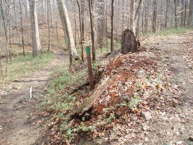
Trail Notes: Cross the Fox Catcher Covered Bridge and immediately turn left onto a wide path. Follow the sporadic green blazes along Big Elk Creek for 0.30 miles. Cross Black Bridge Rd and continue to follow the green blazes and blue diamonds. Trails and roads will branch off to either side of the main trail but it is well marked with green blazes. The first occurs at 0.12 miles after crossing the road. The Blue-Diamond Tr will follow a road to the left. Continue straight on the Green Trail at this point. Gradually climb up a low ridge and in 0.47 miles from the last trail split arrive at the first of several open fields. Follow Joey along the right edge of the field. In another 0.19 miles the trail will make a sharp right back into the woods. In 0.12 miles pass the ruins of an old stone barn on the right. Then turn right alongside an old farm house. Enter another open field. In 0.13 miles turn left and in another 0.22 miles arrive at a gravel road. The Blue Loop goes straight and to the right. The Blue Diamond Trail is to the left and also to the right. Turn right. The Green Loop Tr will share the gravel road with the other 2 trails for a while. Marker posts will carry all 3 blazes. In 0.13 miles cross a gravel road (Black Bridge Road - this can be used as a quick return route should you need to end the hike.) Parking Area 3 and port-a-potties are to the left. In another 0.37 miles the Blue Loop Tr will turn left and go under Appleton Road. (There are more ruins there but they are in the middle of thorn thickets and nearly impossible to get to.) Continue straight on the now Green Loop/Blue Diamond Tr and soon pass Old Union School Road on the right. (This is another good bailout route.) In 0.87 miles the Green Loop Trail turns right and parallels Rt 273. This is the last bailout route. To complete the hike as described continue straight on the Blue Diamond Tr, crossing Rt 273 on a footbridge. In 0.20 miles, just as you re-enter the woods, the Yellow Loop Trail will come in from the right (Yet another bailout route). Stay on the Yellow Loop/Blue Diamond Trail straight ahead. In 0.53 miles arrive at a gravel road (Left and straight ahead. The Blue Diamond Trail continues straight on the gravel road and will rejoin the hike later. Turn right onto a yellow blazed footpath. In 0.14 miles the trail splits. The right fork is an Equestrian detour. Take the left fork. The Equestrian detour will rejoin the trail on the right in another 0.23 miles. There are other trails coming in from both sides. While these might be fun to explore, they may be confusing w/o a park map. Continue to follow the yellow blazes to a gravel road (Blue Diamond Trail) left and right (Dirt). Stay straight on the road (Yellow Loop Tr) walking toward Big Elk Creek. In 0.13 miles from joining the road pass the Scott's Mill ruins on the right. |
|
From here you
can see a
bridge crossing the creek. You'll pass another road on the
right before that. While it can be used to close the loop it
stays away from the creek for much of its length. The same can
be said if you continue to follow the Yellow Loop Trail on the
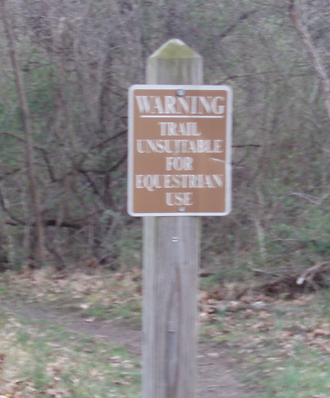
other side of the creek. A better alternative to both is to turn
right on a fisherman's trail just before the bridge. It is
marked with
this
"Warning - Not suitable for Equestrian Use" sign. Some of
the previously passed roads and trails will join from the right.
Continue to follow
Big Elk Creek upstream. Look for
old bridge ruins along the way. In 0.57 miles the Blue
Diamond Tr will come in from the right. Shortly after that the
Yellow Loop Tr will join your circuit again as it crosses the
creek on a
footbridge on the left. Stay straight following the Yellow
Loop/Blue Diamond Trail. In less than 0.10 miles the Yellow Loop
Trail will turn to the right. Stay straight along the creek
following the Blue Diamond Trail. In 0.27 miles
pass under Rt 273 and come to a T junction with what I
believe is old
concrete Rt 273 with a bridge over the creek to the left.
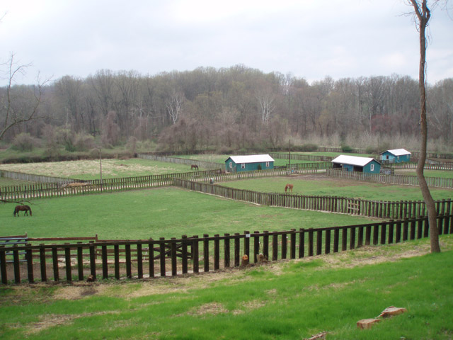
Turn right here but in a handful of steps turn left onto the Green Loop/Blue Diamond Trail and follow a dirt/gravel road uphill for 0.67 miles to the intersection with Old Union School Road. Turn left. In 0.38 miles pass a horse boarding facility on the left. Here the road becomes paved. In another 0.23 miles cross the Fox Catcher Covered Bridge and arrive back at your vehicle. ________________________________________ More Photos
________________________________________
Name: Vince
Hike: Fair Hill green trail (north loop) ________________________________________
Name: Kim
Hike: Fair Hill NRMA - 2 ________________________________________
Name: Paul
Denbow
Hike: Fair Hill NRMA-2 ________________________________________ |
|
|


