| French Creek State Park-West |
|
Description: French Creek State Park is comprised of nearly 8000 acres of mostly forested rolling terrain. Almost 40 miles of trails, including 8 miles of the long distance Horse-Shoe Trail, provide easy access to nature in an area so close to the metropolis of Philadelphia (less than an hour�s drive). Most of the trails on the west side of the park form overlapping loops, allowing the hiker to tailor a hike to his/her liking. Short sections of the trails can be pretty rocky but contrary to popular belief they are short lived and in just certain areas. Good hiking boots should take care of those problems. Described here is a moderate 11 mile circuit hike circumnavigating most of the west side of the park. Google Maps Custom Driving Directions The hike starts at the Hopewell Lake Boat Launch Parking Area. |
|
________________________________________ |
Zipped National Geographic TOPO! GPS and Universal GPX Files |
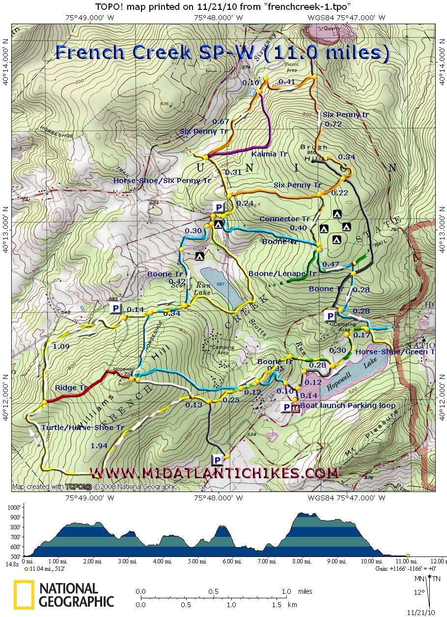
Trail Notes: from the parking loop walk down to the lake and turn left onto a wide gravel trail. In 0.14 miles turn left at a �T� intersection. In another 0.10 miles cross Park Road and join the blue blazed Boone Tr. The trail will switchback up the side of Williams Hill for 0.35 miles where the yellow blazed Horse-Shoe Trail joins from the right. In a mere 0.12 miles the Boone Tr will turn to the right to climb up to the Hopewell Fire Tower. Stay straight on the Horse-Shoe Tr. In 0.25 miles pass an un-named spur trail on the left that leads to a parking lot on Park Road. In another 0.13 miles the white blazed Turtle Tr joins from the right. The trail will now carry both blazes. From here the trail will be mostly flat or downhill for a while. Pass the red blazed Ridge Tr (also goes to the fire tower) in another 1.94 miles. Continue to lose elevation for 1.09 miles as you cross Fire Tower Road (Parking to the left). In another 0.14 miles the Boone Tr will come in from the right to rejoin the route as the Turtle Tr leaves in the opposite direction. In 0.34 more miles bear left staying on the Boone Tr as the Horse-Shoe Tr goes right. For the next .42 miles you might get glimpses of Scott Run Lake to the right. Cross Fire Tower Road again and traverse an area that appears to be old farm land struggling to return to forest. Thankfully the stunted trees, heavy vines and thorns end in 0.30 miles. Cross Fire Tower Road for the last time and turn left onto the joint Boone/Horse-Shoe Tr. In a few steps turn right onto a gravel road. A group campsite is to your right. It�s a nice place for a break if it is unoccupied. The Boone Tr continues on the road as you veer left onto the continuation of the yellow Horse-Shoe Tr. In 0.24 miles you will crest a finger of Brush Hill where the Six penny Tr joins in from the right. Gradually descend for o.31 miles and turn right onto the continuation of the Six penny Tr leaving the Horse-Shoe Tr behind. You�ll also pass the southern terminus of the purple Kalmia Tr on the right. The trail becomes a gravel road. In 0.67 miles of easy walking pass the ruins of the original day use/ bath house area of the park constructed by the C.C.C. in the �30s. The galvanized wire baskets lying about used to store the bathers� personal effects. The pond behind the dam used to be much larger. Look around for old pipes and water fountains. The Kalmia Tr has its northern terminus here. |
|
In another 0.10 miles turn right off of the road. In 0.41 miles a spur trail from Rt345 comes in on the left. The trail makes a hard 90 degree turn to the right and climbs to the top of Bush Hill in another 0.72 miles. There will be an old service road in front of you that leads to the campground. The trail bears away to the left without crossing it but crosses it in another 0.34 miles. In 0.22 miles turn left onto an un-named connector trail blazed in orange with a green stripe. Skirt the family campground for 0.40 miles. Both the Boone and Lenape Trails come in from the right. Blazes will become blue and green. In 0.47 more miles the Lenape Trail will go to the left as you turn right to stay on the Boone trail. Cross the campground entrance road and in 0.28 miles cross Park Road. The trail turns left and closely parallels the road before turning towards the lake. In 0.28 miles come to a new bridge over a boggy area. Turn right without crossing it onto the green and yellow blazed Horse-Shoe Trail. In 0.17 miles the trail turns left onto a gravel road. In 0.30 more miles the Horse-Shoe Tr leaves the gravel road going back into the woods on the right. Stay on the gravel road until it ends at a footpath. Weave through a swampy area for 0.28 miles and cross a bridge in front of a pretty impressive beaver dam. Turn left and in 0.12 miles arrive back at the original �T� intersection. Retrace your steps back to your vehicle. ________________________________________
________________________________________ |
|
|