|
Grayson Highlands State Park Circuit |
|
|
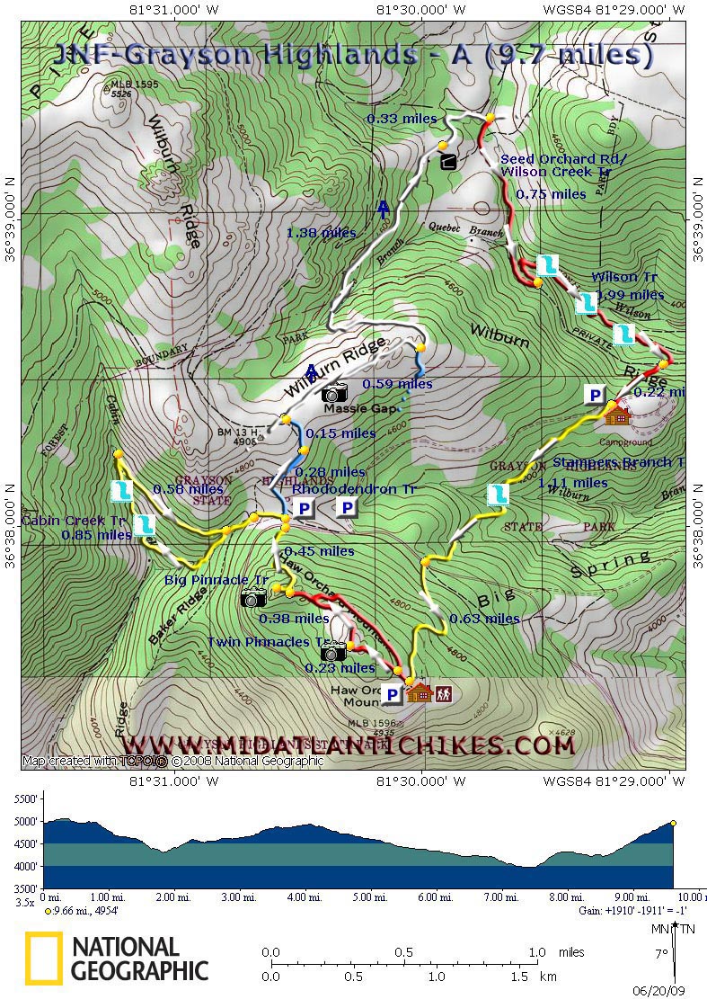
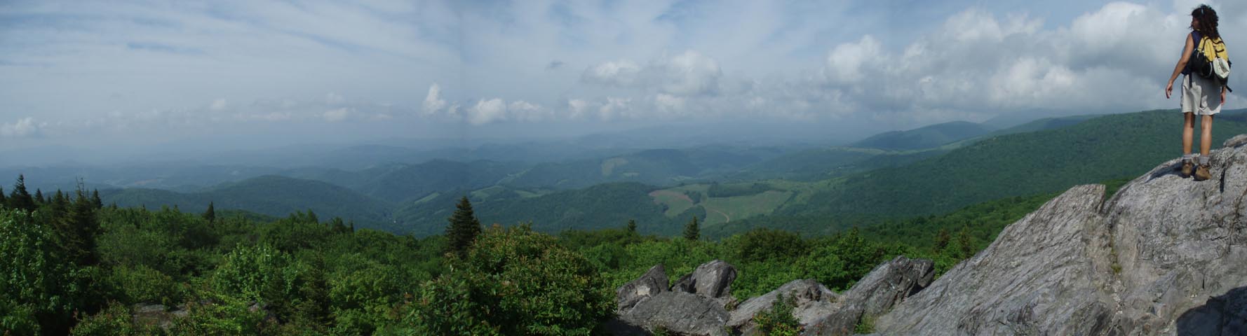
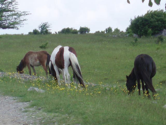
Description: The combined Grayson Highlands and Mt. Rogers National Recreation Area has to be the biggest crown jewel in the VA hiking crown. I can only say that no other hike in VA comes close to what this venue has to offer you. Combine the waterfalls of Cabin and Wilson Creeks with the exposed balds of the Highlands, volcanic looking rock formations to play on, the constant changes in landscape, fields and tunnels of Catawba Rhododendrons blooming in mid-June, clusters of Mountain Laurel and Flame Azaleas at the lower elevations in May and June, Rhododendron maximum (white Rhodos) in bloom along the streams in July, vista after amazing vista .... and then throw in the wild ponies like a cherry on top of a giant Banana Split and you have the Highlands! Described here is a 9.7 mile circuit through it all. If time is of the essence or if there has recently been a prolonged dry spell you may want to eliminate the Cabin Creek Loop making the trip 2 miles shorter. If the water levels are expected to be high it is a "must do" hike. |
|
Google Maps Custom Driving Directions There is a day use fee and a fee for overnight parking. Once you pass the gatehouse follow the park road to its end at the Visitor Center. There are four possible starting points for this hike. It is described here as starting behind the Visitor Center, on the left side. (See the map for other possible start points.) ________________________________________ |
|
Zipped National Geographic. TOPO! GPS and Universal GPX Files GPS Text File for Non-TOPO! Users
|
Trail Notes: All serious stream crossings save one are via sturdy bridges. The crossing of Big Wilson Creek on the Seed Orchard Road is a shallow ford.
Pick up the Red blazed Twin Pinnacle Trail at the left-rear of the Visitor Center. It starts as a wide gravel trail. Bear left at a kiosk in about 0.1 miles. In 0.23 miles check out the tree whose roots have grown around a large boulder. Climb a set of rock stairs and shortly arrive at the first of many grand vistas, Little Pinnacle. in another 0.38 miles bear left at a split in the trail and climb steeply to the second view point on Haw Mt (Named after the numerous Hawthorn trees encountered.), Big Pinnacle. The views are similar to the last except now you can look down into Massie Gap. You'll be there shortly.
Descend the way you came but take care. Partway down bear left onto the yellow blazed Big Pinnacle Trail. In 0.45 miles cross the main park road you drove up on. Descend into a grass field and walk straight ahead to the trail signs. To completer the Cabin Creek Loop turn left and pickup the yellow blazed trail of the same name. In about 0.1 miles cross a horse trail and in a similar distance bear left at the fork in the trail. The other trail is part of your return leg for this side hike. You'll rock hop a small tributary twice before reaching the creek. At that point the trail turns right and follows the east bank of the creek for 0.85 miles. Almost immediately the water works start. At 0.85 miles from the trail split and after gazing at several nice falls arrive at a wide grade on the right. A trail continues straight ahead to a "waterfall vista" but you'll probably have to climb down into the creek and bushwhack upstream to see anything. to finish this little loop take the grade back to the last split (0.58 miles) and follow your earlier steps back to Massie Gap.
Once back at the signs turn left and pickup the blue blazed Rhododendron Trail. Walk through a gate (Please close all gates behind you. They're to keep the ponies in.) and climb gradually up to what I call the Lower Wilburn Ridge. In 0.28 miles a horse trail comes in sharply from the right. Continue straight and in 0.15 miles reach the AT. Here the surroundings really open up. You have an almost 360 degree view with the Pinnacles you just hiked behind you and Wilburn Ridge and Mount Rogers in front of you. |
|
Turn right here. There are a several nice rock outcrops to the right but there is a path leading to the top of one. I think it's the the second one on the right of the trail but I'm not sure. If you find your way up to the top you'll be at the best lunch spot on the hike.At 0.59 miles from joining the AT pass the blue blazed AT Spur on the right that leads to the overnight parking lot. Descend into the Quebec Branch drainage. You'll pass through two stiles designed to keep ponies in but let hikers pass through. In 1.38 miles from the AT Spur arrive at the Wise Shelter. There is a privy and spring close by. This makes for a nice break spot.
In a short distance cross Big Wilson Creek on a bridge and then scale a ladder over a fence. In 0.33 miles from the shelter turn right onto the unsigned but obvious Seed Orchard Road - a horse trail. Shortly after this the Scales Trail comes in sharply from the left at the shallow ford of Wilson Creek. Make the ford and bear left and continue to follow the horse trail. In 0.75 miles from leaving the AT make a hard left onto the red blazed Wilson Trail, leaving the horse dung behind you, and descend to this picturesque creek. The next mile takes you up and down through thick Rhododendron but never leaves the creek. There are several places to stop and refresh yourself. The trail then abruptly turns right and climbs away from the drainage. Cross the horse trail you hiked on earlier and climb steeply for 0.22 miles to the park camp store. Turn right, passing the store, and then turn left toward the amphitheater. You'll see a yellow post for the Stampers Branch Trail on the right. Follow it for 1.11 miles, crossing Wilburn Branch on a bridge as you go. Cross the main park road and regain the Stampers Branch Trail. Climb, steeply at times, for 0.63 miles back to the Visitor Center.
________________________________________
________________________________________ |
|
|