|
Greenbrier State Park |
|
Description:
Greenbrier SP is located minutes off of I-70 and west of Frederick,
MD. It is popular among hikers, mountain bikers, campers and
fishermen. The focal points are 50 acre Greenbrier Lake and the
surrounding hills and a view of Annapolis Rock on South Mountain.
The trail system is well groomed and marked with a map kiosk at
every trail junction. Oddly these maps are not marked with the
typical "you are here" labels. If hiked in the direction shown here,
most of the climbs are barely noticeable. Probably the only
exception is the short climb to gain the ridgeline of Short Hill on
the eastern side of the park. With the overall gentle slopes of the
grades and numerous "bail out" points in case the hike needs to be
truncated, this is the ideal place for beginners and younger
families.
At the park road split bear right and proceed to the launch ramp parking area. |
|
_______________________________________ |
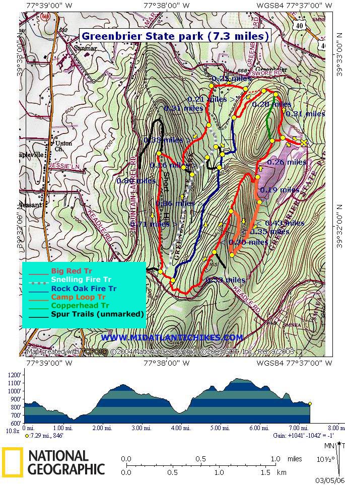
Zipped National Geographic. TOPO! GPS and Universal GPX Files |
Trail Notes: Trails are blazed in different colors. The colors on this map match the blazes. From the launch ramp parking area cross a grassy "back" dam to a kiosk at the Big Red trailhead which goes either straight into the woods or left onto a gravel road. Proceed straight into the woods. In 0.31 miles pass green blazed Copperhead Tr on the left. Soon come to a trail closure (Habitat renewal) and a trail relocation to the left. Turn left and follow a footpath as it loops through a shallow valley. In 0.28 miles pass the junction of blue blazed Rock Oak Tr on the left. At this point the trail will make a hard right and, follow the other side of the valley back out to the other side of the trail closure (0.21 miles from the last trail junction). At this point turn left onto the original trail. In another 0.36 miles the trail makes another hard left and begins a gentle climb. Along the way you'll pass some domesticated Yew bushes on the right and then, if you look closely, a short section of stone wall, also on the right. These are indications that a home once stood here. In 0.36 miles from the last turn pass the northern terminus of the gray Snelling Fire Tr on the left. Here is where the grade gradually increases and reaches its steepest part at the junction of a spur trail on the left. At this point the Big Red turns to the right and continues at a much reduced grade until you reach another spur trail on the right that leads to a parking area. Turn left to stay on the Big Red Trail and traverse Short Hill on almost level tread. In the winter you can get partial views to the east through the trees. In 0.8 miles from the last junction arrive at the southern terminus of gray blazed Snelling Fire Trail. To shorten the hike by about 2 miles stay on the Big Red Trail and pick up the directions later in this description. To complete the circuit as described turn left onto the Snelling Fire Trail. Gray is not a very good color for blazes as most of the trees in the park has gray bark. I think the park management realized this as there are also white blazes along the route. In 0.71 miles pass a spur trail on the left and then another on the right. Continue a short distance to another spur trail on the right. Turn here and cross a small stream. This is a good lunch spot and is about midway through the hike. |
| From here
turn right onto blue blazed Rock Oak Tr. Soon pass another spur
trail that seems to cross an earthen dam that once impounded a
small pond. There is no breach in the dam yet the pond no longer
exists. In another 0.86 miles rejoin the Big Red Tr. The place
where you you left the Big Red Tr earlier is only a couple
of 100 yards to your right! Turn left onto the Big Red Trail. In
0.53 miles pass the junction of an abandoned trail on the right
that still leads down to the campground. The map has been
removed from the kiosk. Continue straight for another 0.3 miles and arrive at the junction of orange blazed Camp Loop Tr. To shorten the hike by about 0.6 miles stay straight on the Big Red Trail and follow it back to the start of the hike. To complete the circuit as described turn right onto the Camp Loop Tr. In about 0.35 miles a spur trail will continue down into the campground. Make a sharp left here and follow the orange blazes out to the lake. Turn left onto an asphalt footpath and cross a bridge. In another 0.19 miles rejoin the Big Red Trail and follow it back to the first kiosk of the trip, crossing the dam and passing the southern terminus of green Copperhead Tr on the left. Retrace your steps across the grassy "back" dam you originally crossed. Printable/Downloadable Directions and Trail Notes ________________________________________
________________________________________
Name: Adventure Runner
Hike: Greenbrier State Park ________________________________________
Name: BikeDC101
Hike: Greenbrier State Park ________________________________________
Name: Trillium
Hike: Greenbrier State Park ________________________________________
Name: Rob
Hike:
Greenbrier State Park
M.R.Hyker Note: We at Midatlantichikes.com cannot control the weather. ________________________________________ |
|
|