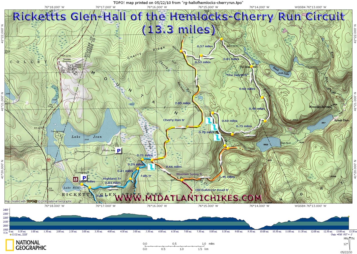
| Hall of the Hemlocks-Cherry Run Circuit |
|
Description: Jeff Mitchell, author of �Hiking the Endless Mountains� and other fine PA hiking guides, calls this one "the Secret Side of Ricketts Glen". It uses seldom traveled Mountain Spring and Cherry Run Trails and connects the two through a series of unofficial trails that have been maintained by Wayne and his mountain biking/cross-country skiing friends since the mid-80s. If you ever see any of them on this route be sure to thank them.
Described here is a 13.3 mile moderate loop with very little in the way of strenuous elevation gains and tons of solitude. Most climbs are short and used to jump from one old grade to another. The �secret� part goes through huge Hemlock Groves and a very pretty rocky gorge filled with the sounds of white water. The place is �secret� because no hikers knew about it until Jeff met Wayne and was given the grand tour and then Jeff mailed me a map. |
|
If need be the hike can be shortened by about 2 miles by starting at the Ricketts Glen Beach parking lot. (See the extra parking icon on the map.) This also isolates you from the hordes that will be doing the Falls Hike on nice days. (You can also add this one to your trek if you have the time and energy. It will bump the mileage up to a little over 14 miles.)
Once in the park cross the dam and follow the sign on the right to the trailhead. If this lot is full start at the Beach Parking Area. ________________________________________ |
Zipped National Geographic TOPO! GPS and Universal GPX Files |
Trail Notes: From the large wooden map and kiosk head down the spur trail to the junction with the Highland Trail to the left and the Falls Trail to the right. Take the Highland Trail. Pass through the Midway Crevasse. Soon pass the R.L. Ricketts Shortcut Trail and the other end of the Falls Trail both on the right (1.05 miles from the parking lot spur.). The trail then turns left onto an old haul road and climbs to a 3-way intersection. The trail to the left leads out to the beach/cabin area and optional parking for this hike. Continue straight passing the blown out dam of now dry Lake Leigh on the left. At the end of the dam the Mountain Spring Trail comes in from the right. (You will come up this trail later.)
Continue straight on the Cherry Run Trail. This is a wide grassy haul road that can become quite muddy in flat areas. In 2.85 miles from the last trail junction find a small rock cairn and log on the right side of the trail. Turn here onto a well established footpath. Initially you will be walking through a predominantly Beech forest as you were before. For the most part this serpentine trail is obvious but keep a sharp eye out for cairns, an occasional blaze of no specific color, bike tire tracks and hatchet marks in the bark of trees to keep you �on trail�. You will soon enter �The Hall of the Hemlocks�, the first focal point of this hike. This is probably the easiest place to get confused as the trail seems to apparently just stop before reaching a small stream with mossy banks. Look for the continuation of hatchet marks as the trail makes a near 90 degree left hand turn to avoid the stream. |
|
In 1.10 miles from leaving the official trail descend to the North Branch of Bowmans Creek but follow it downstream for just a few steps before veering to the right and climbing steeply for a short distance to an old grade. Follow this grade for 0.81 miles to an old RR grade lined in Hemlocks. Turn right onto it. This section seems as straight as a yard stick as it hugs the ridge passing through alternating forests of Beech and beautiful Hemlocks. In 0.60 miles from joining the grade the trail abruptly leaves it to the left but in a short distance turns right onto another one. In another 0.48 miles the trail leaves the grade, turning sharply to the right on a narrow footpath and climbing a short distance to the top of the ridge where it meanders for p0.75 miles before joining another grade which drops down in 0.60 miles to the second focal point of the hike, Cherry Run. The trail turns left and crosses the stream for the first of 3 times on another old RR grade. Crossings are usually rock hops. After the last crossing the trail will veer away to the right away from Cherry Run. Cross the South branch of Bowmans Creek near an old defunct park bridge. Turn left onto another grade and walk downstream just a bit before climbing to the right on a narrow footpath to an orange diamond blazed haul road. This is the Mountain Spring Trail.
The �secret� part of the hike is now over. If you wish to extend the hike turn left here and hike out and back to Mountain Spring Lake. Otherwise turn right and slowly climb along the Bowmans Creek drainage crossing it on a wooden bridge. In 1.46 miles from joining this trail the Old Bulldozer Road Trail (red diamond blazes) comes in sharply from the left. Continue up the trail for 0.66 miles to the dam you passed earlier, passing a forgotten waterfall on the left just before the junction. To finish the hike as described turn left and retrace your initial steps. If you still have the time and energy to do it consider adding the Falls Hike to the end to increase the overall �bang for the buck�. Don�t expect to be alone on this part though!
________________________________________
________________________________________
Name: Peter
Gebhard
________________________________________
Name: Tom
Hike: Hall of the Hemlocks Still, they all completed the hike and we spent the weekend at RGSP. This is a great hike with plenty of solitude. I wish it were longer. ________________________________________
Name: T. Axel
Jones
Hike: Hall of the Hemlocks See T. Axel's U-Tube video here. ________________________________________ |
|
|