Cat Rock Circuit

Description: This loop can be done as a 7.4, 8.6 or 11.0 mile moderate circuit hike. There is a 850 ft elevation gain over 1.5 miles. The rest of the trek is either flat or downhill with a few short rolling hills to break up the monotony. Some sections of the Catoctin Trail are pretty rocky, especially the downhill sections. It includes hiking along Hunting Creek on an unofficial fisherman’s trail, fantastic views from Cat Rock and Bob's Hill and the ever popular Cunningham Falls. There are 2 stream crossings of note. The last, Hunting Creek below Cunningham Falls may prove problematic during periods of high water.


Cunningham SP/Catoctin NP is a very popular venue for many Marylanders seeking some time in the great outdoors. Most hiking is done on the Catoctin side of the mountain with great views from several vistas. On the Cunningham Falls side the focal point is the falls themselves. This leaves a large section of trails in between left virtually un-used. I like to hike this route in the fall and winter to avoid the crowds in the rest of the area.

Google Custom Directions

Start the hike at the Catoctin National Park Visitor's Center.

Printable/Downloadable Map


Trail Notes: There are some important things to remember about this venue. First, Catoctin NP uses no blazes on the trails. There are sign posts at all trail intersections. Cunningham Falls SP uses signs and blazes. Old painted rectangular blazes are being replaced by small metal triangles painted the same color. You’ll probably see both. Secondly, a word about pets. Catoctin NP allows dogs if they are on a lead at all times. Cunningham Falls SP allows dogs on leads only south of Catoctin Hollow Road. The section north of it, which includes the campground and waterfalls is off limits for Fido. Since this loop goes right through that area, he/she will have to sit this one out.


From the visitor Center cross MD 77 and walk over to Hunting Creek. Turn left and follow the creek downstream, soon walking in the shade of Hemlock trees as you go. Keep an eye out for trout in the stream. Eventually you will pick up an obvious footpath used by fishermen. Follow it east. At two points the hill on the left will force you up onto the road but you should be able to descend to the creek in only a handful of steps. As you near the Cat Rock Trail parking lot the bank will become just too steep and rocky. Climb up to the road and walk downstream a short distance to the parking lot for this trailhead (1.0 miles from the visitor Center).


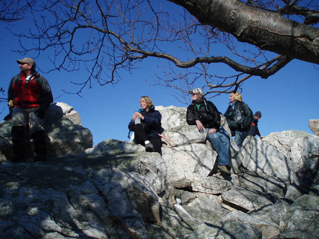
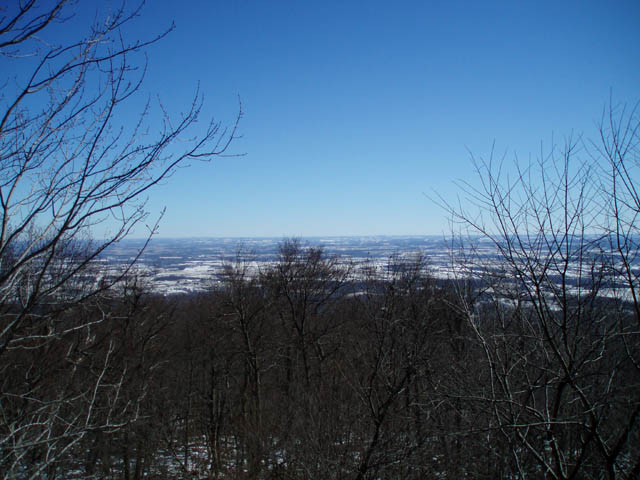
Begin a steep climb up yellow blazed Cat Rock/Bob’s Hill Tr. At about 0.93 miles pass the junction of orange blazed Old Misery Trail on the right. Soon pass through a power line swath. In 0.35 more miles reach the spur trail to the left that takes you to Cat Rock. This is a great break spot. Be prepared to scramble up some rocks before taking in the view. In the summer watch where you place your hands and feet. Both Rattlesnakes and Copper Heads can be found amongst the rocks.


Return to the main trail and turn left. As you climb to the top of the ridge look to your right for a view of Chimney Rocks to the north-east. The best chance of a full view is in the winter. At about 1mile from the Cat Rock spur trail there is a short-cut that comes in sharply from the right. I believe it to be an old intersection of Catoctin Trail and Cat Rock/Bob's Hill Trail. There is a short log and two very old sign posts blocking the trail. It is further marked by a small cairn at the base of a tree. If you want to do the 7.4 mile version turn right here. In a few hundred yards you will join the blue blazed Catoctin Tr. Pick up the directions later in these notes to complete the hike.


To do a longer version of the trek continue on Cat Rock/Bob’s Hill Trail. At 1.50 miles from Cat Rock or 0.57 miles from the short-cut arrive at the junction of blue blazed Catoctin Trail. If you want more views turn left and hike 1.2 mile to Bob’s Hill. This section of trail is blazed with blue rectangles and yellow triangles. The spur to the left is short and takes you to a partially overgrown view to the west and north. The right spur is longer and gives wide open views to the east as well as south. If you opt not to visit Bob’s Hill turn right at the Bob’s Hill Tr/Catoctin Tr junction and follow the rest of the directions. This shortens the hike by 1.4 miles (8.6 miles).


If you visit Bob’s Hill return to the last trail junction and continue up the blue blazed Catoctin Trail. Initially this is an old woods road. Ina short distance the trail makes a right turn onto a rather sketchy footpath. (If you miss this turn-off and continue down the woods road you’ll arrive at a grassy field with a barn in the middle of it. If you come to this point retrace your steps and look for the correct turn-off.) Initially the footpath traverses a rock scree. The way is well blazed though. The trail condition soon improves. At about 0.57 miles from the last trail junction Catoctin Trail will make a hard left onto another woods road. At this point look to the right. Note some logs blocking the old road. This is the other end of the short-cut described earlier.( If you are doing the shortest version of the hike your options at the end of the short-cut is to either turn left or go straight on blue blazed Catoctin Tr. Go straight.) Make the left following the woods road. It will soon peter out. The trail resumes on a footpath to the right. As it descends through a couple of long switchbacks you’ll walk on some pretty rocky trail.


At 1.24 miles from the last trail junction arrive at and cross Catoctin Hollow Rd and continue along the blue blazed Catoctin Trail. You’ll come to the campground entrance road at 0.52 miles from Catoctin Hollow Road. The continuation of the trail is to the right on the other side of the waste dumping station.


In another 0.48 miles the yellow blazed Cliff Trail will come in from the right and share the tread for a bit. In another 0.13 miles turn right onto the continuation of yellow blazed Cliff Trail, passing orange blazed Campground Tr and then the continuation of the Catoctin Tr on the left, and follow it down to the Falls. This falls used to be a wide open area to explore but is now isolated by boardwalks and viewing platforms. After taking in the falls back off a bit from the boardwalk and rock hop across the creek to the boardwalk/gravel path on the other side.


Follow the gravel trail out to MD77. Cross it, turn left for a short distance and then right into the woods again. Follow this trail a short distance to the Falls Nature Trail on the right and follow it back to the cars (1.14 miles). The Falls Nature Trail is in Catoctin NP.

Printable/Downloadable Map

 View 3-D Map!  

Zipped National Geographic. TOPO! GPS and Universal GPX Files

  GPS Text File For Non-TOPO! Users

Printable/Downloadable Directions/Trail Notes

 Critique this outing! ________________________________________


________________________________________


Name: Keith Robertson                                                                                           Hike: Cat Rock Circuit                                                             
Date: 3/21/10                                                                                                          Rating: 4

Critique: A friend and I recently hiked this trail. We did not do the entire loop as described, instead opting to start at the trailhead for the yellow-blazed trail at the parking lot on Rt. 77 for an in-and-out of 7.5 miles. The first mile or so was fairly strenuous until just past the power line cut, right before Cat Rock. The rest of the trail leading to Bob's Hill mostly follows the ridgeline, and was easy. Cat Rock is a great little scramble with decent views, and the views looking south from Bob's Hill were excellent (from the north overlook, not so much.)

We also found several dead trees that had very recent signs of a bear clawing them apart to look for insects. We didn't see the bear(s), but I'd recommend that anyone else who goes out there to keep an eye out.

________________________________________


Name: Steven Powers                                                                                             Hike: Cat Rock Circuit
Date: 6/27/2009                                                                                                      Rating: 4

Critique: Definitely a great hike... Not Old Rag great... but still great.

The only critique I have about this is that the first leg of the hike (Fisherman's Path) is a little vague, hard to find, and not an official maintained trail.

Better directions would be to simply follow the stream or the road to the cat rock trail head.

The fisherman's path itself is overgrown in most areas and impossible to follow.

Another problem I had in following these directions was that the gravel path that was supposedly near the falls is no longer there. Its all boardwalk now a days. If you do follow the only existing gravel path you will end up at the lake... which is not where your supposed to go.

Do watch out for snakes... I saw 3 (1 rattler) within the first 2 miles.


________________________________________


Name: Greg and Sarah                                                                                            Hike: Cat Rock Circuit
Date: 03/24/07                                                                                                        Rating: 5

Critique: We drove from the Pittsburgh-area that morning to hike the Catoctin Mountain hike but discovered upon entering the visitors center (with no help from the unfriendly park ranger) that the President of the United States had taken over the area, so we opted for the Cat Rock Circuit. The weather was foggy so our visibility from Cat Rocks and Bobs Hill were limited to nothing. The weather was cool and we experienced a brief shower as we approached Catoctin Hollow Road. All the rain the area received the previous days led to a spectacular display of Cunningham Falls and some slippery conditions along the trail and stream crossings (expect to get wet if the water is high!). We enjoyed the hike (the fog provided an interesting aspect) and the solitude the weather provided us. We are definitely coming back to hike the Catoctin Mountain hike but we will check the NPS website before we make the 3 hour drive. This isn't the first hike we have completed from your website and we look forward to doing many more. Thanks for providing great information.

________________________________________

Name: TreebeardIM                                                                                                Hike: Cat Rock Circuit
Date: 1/19/07                                                                                                         Rating: 5

Critique: This is my favorite day hike in Maryland. I do a modified version of this; in that I start my hike at the Catcotin Visitor's Center. I then go to Cunningham Falls, retrace back to the fork that takes you to Hog Rock, Blue Ridge overlook, Thurmont Vista, Wolf Rock, Chimney Rock, down and cross 77, then up to Cat Rocks. I then either go to the junction of the Catoctin Trail or if I want a quicker day, come down the Old Misery Trail. This route is about 11 miles. I would just like to add another little area to this hike description. It was mentioned to me that there might be another rock out-cropping close to Cat Rocks. Well there is:


At Cat Rocks, there is a small unmarked trail that leads away (perpendicular) from Cat Rocks. You then bend around to the right a bit and you can spot another interesting rock formation (it is about .15 miles from Cat Rocks).
The rocks don't provide the view of Cat Rocks, but it is a nice quick area to check out.

________________________________________

Name: Dean Simmons                                                                                            Hike: Cat Rock Circuit

Date: 02/25/06                                                                                                       Ranking: 4

Critique: I led a Northern Virginia Hiking Club outing over this route and got rave reviews from all participants. I had planned the standard Catoctin Route coupled with an ascent of Cat Rock, returning via the Old Misery Trail. However, several hikers pushed for the Cunningham Falls option when I told them that I had an alternate routing in case parts of Catoctin were closed by the President's being at Camp David. He wasn't there this weekend, but my hikers argued, correctly, that lots of hikes go around Catoctin, but few ever go through the State Park and they were in the mood for a change of scenery. So, we proceeded along the Cunningham Falls State Park route laid out here. The weather was delightful for a change. The trails were all in good shape with no ice or snow and hardly any muck or mire. The views from Cat Rock and the two Bob's Hill overlooks were excellent. The Falls were awesome with significant ice along the edges although the creek was ice free for the tricky below-falls ford necessitated by the southern approach taken by this route. We started at 9:30 and were done before 2:30. A great hike!

________________________________________

Name: Brandon Miller                                                                                             Hike: Cat Rock/Bobs Hill/Cunningham Falls
Date: 4/8/2006                                                                                                       Rating: 4

Critique: To start off with...this would have been a 5 rating except for personal preference. I prefer some rock scrambling, but Overall the trail was exceptional. In the beginning of the trail you follow a beautiful stream with trout and rolling rapids for approximately one mile. This part of the trail is not marked very well, just follow the stream and the written instructions provided on this website. On the second mile, you begin a strenuous uphill hike that opens up to the Cat Rock viewing area. The rest of the hike is fairly easy and travels through some beautiful valleys. You will pass streams, rock outcroppings and beautiful scenery. The pot o' gold at the end of the rainbow is Cunningham Falls. While there is no climbing allowed on the falls, just start hiking at 6:30 a.m. when it is raining and no one will be there to stop your childish fun :) This is a beautiful hike because it is a good distance for a day hike, the hardest part is in the beginning, the falls at the very end are beautiful and the scenery is always changing. My personal favorites were Billy Goat Trail and Sugarloaf's Blue and White trail until I stumbled onto this hike.

We started this hike at 6:30 and ended at 12:00 because we played on the falls for thirty minutes. My group traveled fairly quick and it still took 5 1/2 hours. Have a great time and please pick up some trash along the way...some people just don't care.

________________________________________

VA Hikes MD Hikes WV Hikes PA Hikes Contact Us Home