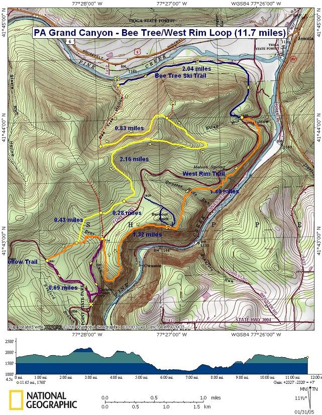
|
Bee Tree Ski Trail - West Rim Loop |
|
Description: When most hikers hear about the PA
Grand Canyon they think of backpacking the 35 mile West Rim Trail.
Seldom do they think of all of the possible circuits that might be
made using adjacent trails. Chuck Dillon, Owner/operator of Pine
Creek Outfitters and author of several outdoors books related to
this region provided me with this loop not found in his �Short Hikes
in
This is a moderate 11.7 miles circuit. It starts and ends at
|
|
want to catch all of the views you can make the hike about 10 miles by starting where the West Rim Trail crosses Colton Rd north of the park or 8 miles by starting at the Barbour Rocks Overlook parking area. The first few miles is primarily a walk in the woods until you reach the north side of a high ridge. Then there is an easy, open-woods bushwhack down to Pine Creek. From there you�ll pass through hardwood, birch, Pine and Hemlock as you follow the Bee Tree Ski Trail to the upper end of the West Rim Trail. Parts of the West Rim Trail are devoid of any views of the Canyon but then other stretches will blow you away. The hike starts at Colton State Park. _______________________________________ |
|
Trail Notes: From the park find gravel
uphill. In about 0.7 miles reach the intersection with the orange blazed West Rim Trail. Turn right here. In about 0.3 miles, come to a fork in the trail. The West Rim Trail bears right towards Colton Rd. Bear left here onto an un-named trail.
Soon cross Bear Run and pass a nice campsite on the opposite bank. Cross through a wet area (about 50 yards long). The trail may be hard to follow at this point but maintain a north-easterly course until you pick the trail up on the other side. At 0.4 miles from the last trail junction come to a four way intersection. Continue straight.
In 0.3 miles from the 4X intersection come to an unmarked spur trail on the right that leads to Barbour Rocks. Continue straight on the main trail. Shortly after this the trail will make a sharp left hand turn. Soon you�ll find yourself walking through a shallow draw of sorts on an old woods road. As you approach the top a footpath scoots up a little, steep hill on the right. Ignore this as it only circles back onto the trail you're on but behind you. Continue up the old road and soon reach the top of the ridge. The trail turns hard right here. Pass areas of recently timbered forest being filled in by dense growths of small trees. All along this segment there is an abundance of black berries along the trail in season.
Descend along the spine of the ridge in an easterly
direction. Soon the trail will reverse its direction and go due west
under the ridge you just traveled. This is a pretty wide, sunny road
at this point. At 2.16 miles from the last trail junction, look for
a faint footpath on the right. This leads to a wooded knob that
looks over Pine Creek and the distant mountains of
Return to the main route and walk uphill for a while. You�ll soon find yourself walking downhill. Watch for a low spot in the road/topography that marks the headwaters of Bee Tree Run. There is no trail. You�re just looking for a good spot to start the open woods bushwhack. If you miss it you�ll soon end up in a clearing used for a lumbering operation. In that case just turn around and search for the low spot. The turn-off is not at |
|
an exact point on the road but is about 0.8 miles from the overlook turn-off previously mentioned. It�s pretty easy finding the slight dip in the road. Assuming you are still heading west on the woods road turn right off of the road and walk down hill in an almost northerly direction. Keep an eye out for signs of a part-time stream, probably on your left since the hill on the other side of the Hollow is a lot steeper than the one your walking down. You may see random yellow sprayings on some trees to the right. Ignore these. As the streambed becomes more defined follow it down to Pine Creek. The bushwhack should be about 0.7 miles long. If water is running in the stream there might be a little waterfall where it empties into Pine Creek. If you�re hiking this in the summer (low water levels in Pine Creek) try to get down on the gravel bar below the stream for some great views and possible wild flower discoveries. This is a great spot for lunch!
After taking this all in pick up the obvious blue blazed Bee Tree Ski Trail and follow it East (downstream). Although the trail approximately parallels the creek there are no views of it to be had unless you bushwhack out to it. Note that the banks are steep and rocky for the first 0.5 miles after turning east onto the trail.
Follow the Bee Tree Ski Trail through constantly changing
hardwood, birch, evergreen and fern plantations. It�s a very
pleasant hike but you can tell that man has had a significant impact
on this part of the forest. In 2.04 miles from the stream arrive at
From here the trail is easy to follow. Initially you�ll get
some views of the canyon before the trail veers away from the rim
and crosses through the hollow formed by Owassce Run. In 1.8 miles
from crossing
If time and stamina allow try to check out the little loop around the park rim trail for even more views. The Turkey Path will take you down to Pine Creek. Printable/Downloadable Directions and Trail Notes Critique this outing!________________________________________
name:
Jack Hike name: Bee Tree Ski Run/West Rim
Trail ________________________________________ |
|
|