|
Fayetteville-Kaymoor Loop |
|
Description:
This is a pretty moderate 8.4 to 12 mile circuit in the
Signage is a problem.
There is none in the |
|
In a couple of other places the signs are a bit misleading. Make sure you bring this map and a good sense of direction with you and you�ll be OK. The longest route includes 4 miles of forest road walking, the first two of which might be boring � unless you�re into wildflowers and doing the hike in the spring or summer!
Note: Turn right immediately after the park onto a gravel road. Trailhead is at its end. ________________________________________ |
Zipped National Geographic. TOPO! GPS and Universal GPX Files |
Trail Notes: The trails of the Town Park Loop are new and have yet to be signed. Also be aware that there is a short connector shown on this map that is not shown on the park handout map. None of the trails on this route are blazed but are quite obvious. From the kiosk proceed along the Town Park Trail. Soon arrive at a fork in the trail and bear right. You will find yourself following an old fence behind the cemetery. An old trail follows the fence for a bit but you will bear left onto a well-worn trail.
In about 0.48 miles from the first fork arrive at a trail
junction straight and to the right. There is a square hole in the
ground where a sign noting the Fayette Tr used to be. Turn right
here onto Fayetteville Tr and switchback down to
In 0.7 miles from the last trail junction arrive at the junction of Timber Ridge Tr on the right. Make a sharp left turn to stay on Fayetteville Tr.
In another 0.87 miles arrive at a 4X intersection with
|
|
Return to the concrete post and turn left onto Butcher Branch Tr. In about 0.2 miles you will come to a 3X intersection with a cryptic sign for 2 directions. One segment leads downhill to a popular rock climbing area. Continue straight up the hill to get to Kaymoor Top. At the trail�s end enter a USPS parking lot. Fayetteville Tr comes in from the right at the same trailhead.
Continue along Kaymoor One road checking out the remains of the Kaymoor Haulage as you go. This was a means of transporting workers and citizens down the hill. You probably passed some of the old cable used by it along the Butcher Branch Tr. If you opt to complete the short route turn left and descend on the Kaymoor Miner�s Trail.
If you are completing the entire loop continue along Kaymoor
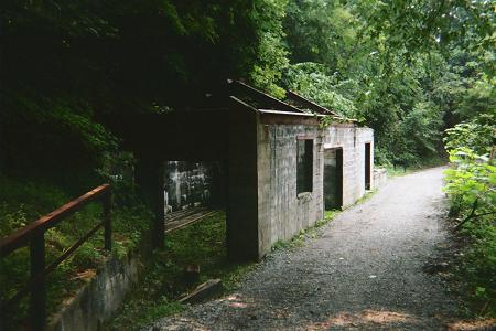
In 2.38 miles the Cunard portion of the trail bears right. You want to turn left here. The descent before this plunges the road quickly through some huge rock outcroppings, Hemlocks and Rhododendron. From the beginning of the descent to the Mine the road walking is a bit less boring but still quite easy. You should make good time through this segment. In 1.72 miles from the Cunard junction arrive at the Kaymoor Mine. Take in the history. It�s hard to imagine grown men working in a shaft only 3 feet tall let alone the damp, dark conditions. There is a set of steps to the right. I�ve been told there are 800 of them by a recent visitor. They lead to the old coke ovens and the remains of the old town. Remember the note in the hike description before descending.
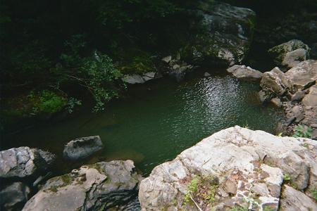
From the mine north the forest road is maintained as a trail and not as a road and is simply called the Kaymoor Tr. You�ll pass yet more ruins before arriving at a partial view of the bridge below Long Point. The trail makes a hard left turn here to follow the Wolf Creek Drainage. Pass a waterfall with a man-made trough before crossing the creek on a steel and wood bridge. Notice the old foundations of previous bridges. In 2 miles from leaving the mine, arrive at the Rt82 trailhead.
Turn left up Rt82 for a few yards before turning left onto
the unsigned beginning of the Fayetteville Tr. It sharply jogs left
toward the creek and then right again onto an old woods road. Climb
steadily for 0.55 miles passing under some utility cables. Arrive at
a short set of steps. Over your right shoulder you�ll find the
I suspect that the next 0.44 miles is an old RR grade or
trolley line given its slope and the large amount of small, loose
rock scattered along its length. As you climb keep an eye out for a
footpath on the left. The old RR grade will continue to climb up to
Quickly descend and climb a gully. Soon reach an unmarked junction. The left is the continuation of Fayetteville Tr. The right is a recently added link not shown on the park map. Turn right here. Soon pass another trail on the left. There will also be a scratchy trail on the right. Ignore it also. Soon arrive at the first fork in the hike. Turn right here and retrace your initial steps back to your car. Downloadable/Printable Directions and Trail Notes ________________________________________
________________________________________ Outing Critiques
Name: Peter
Fleszar
Hike: Fayetteville-Kaymoor Loop ________________________________________
|
|
|