|
________________________________________
________________________________________
Name: Steve Appler
Hike: Halfmoon Lookout
Date: May 4 - 6, 2012
Rating: 4
Critique: Halfmoon Lookout Backpack.
The directions on here to the trailhead are great. We -
Lisa, Greg, Austin and myself, parked and headed up the
trail at about 4:30pm on Friday, May 4. We wanted to set up
camp before dark, so we went in the opposite direction from
that described here since it is about a 1/2 mile shorter
that way. It took us almost 3 hours to get there, but the
trail was open, well marked and a long gradual climb that
wasn't too difficult for our first backpack of the season.
We found the very nice, grassy open campsite below the
lookout, but still climbed up with packs on just in case
there was a better site up higher. There was a very small
site up there, but we went back to the large grassy site
just below and set up. It was a wonderful site with it's own
overlook, though the short climb to the lookout was well
worth the effort and we climbed up a bunch of times.
The only negative is that there is no water anywhere close.
You have to pack in enough for the first night. Saturday
morning Austin and I headed off to re-supply. From the point
where the white-blazed Halfmoon Lookout Spur Trail meets the
yellow-blazed Halfmoon Lookout Trail we walked 1.7 miles
staying on the white-blazed trail until we crossed two
wooden bridges and found an active stream where we loaded up
with enough water to last into the next morning.
We spent the day lounging at the campsite. Very lazy. The
whole loop is fairly short, so we saw no point in moving on
when we clearly had the most spectacular site to ourselves.
Beware of snakes in the rocky overlook area. While everyone
else lounged around napping on Saturday I headed up with my
book and upon spotting the perfect reading rock I headed
down only to find a nice rattlesnake basking in the sun.
After making like Roadrunner and bashing my knee in the
process I retreated to the campsite and napped. That area
must be home to a whole bunch of whippoorwills because
Friday night one started singing and kept appearing in
various places around the camp. It was as curious about us
as we were about it. Its eyes glowed in the light of our
headlamps and it allowed us to approach as it sat on a rock
about 2' off the ground. We got to within about ten feet to
study it until it finally flew off. It hung around all night
and others nearby answered its call frequently. It was a
novelty at first and then we begged it to please go to
sleep. It was very noisy and was still quite noisy Saturday
night. There's cell service (AT&T, but no Verizon) up there,
so (forgive us) we Googled and found that whippoorwills are
active at night and eat insects. They also nest in the
ground, so they are susceptible to predators and are not
often seen.
We also happened to be at the site on the night of the
"Super Moon" which was vivid when not shrouded in haze. We
had rain Friday night, off an on on Saturday and some
Saturday night. Regardless, it was a great relaxing trip.
Very unlike our usual camp, move camp, camp, move camp
marches.
On Saturday Lisa, Austin and I left Greg napping and headed
down the German Wilson Trail to see what awaited us on the
hike out the next morning. It's VERY steep. We hiked down a
good way, saw no reason to keep going, turned around and
climbed back to camp, headed back up on the overlook, said
"hi" to the rattlesnake who was also napping (and Austin had
to sneak down and get a picture of it) and that was that for
exercise for the day. We had a fine dinner (packitgourmet
pizza), slept great and then headed out early and wet the
next morning returning the same way we went in so we didn't
have to slide down the German Wilson Trail.
We didn't see anybody else up there the entire trip. We saw
a tent on our departure hike next to the stream at the
intersection of the Halfmoon Trail and the Bucktail
Connector Trail, but no humans. The hike is like normal
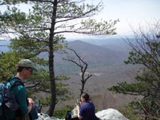
mountain woods. Not particularly exciting and no overlooks
until you get to the top. But once you get to the top the
view is glorious. The rain went away in time for us to get
some beautiful sunset photos. It would be a great day hike
and, as we found, a very relaxing backpack.
________________________________________
Name: Keith Lehman
Hike: Bucktail Trail-Halfmoon Lookout Loop
Date: 4/4/09 - 4/5/09
Rating: 5
Critique: I did this loop in reverse from the directions
given and I think that made it a bit easier than it would
have been going the other way. The climb to the peak is more
gradual and the sun was more hidden on the last few miles on
Bucktail Trail. Going in on the Bucktail Connector offered a
few nice views since the trees hadn't budded in early April
when I did this trip. One note, be sure fill up on water at
the intersection with Halfmoon Trail (yellow blazes). There
is a nice campsite there if needed and the stream will be
the last water you see until you come off the peak on the
other side.
There is a wonderful campsite at the "Cliffside" area about
200ft from the peak. The site at the peak is really only
suitible for a bevy tent. Even in high winds (gusts to
40mph) the Cliffside site was shielded well due to the
terrain deflection.
Heading out the German Wilson Trail was very rocky and you
need to be very careful about rolling a rock under your
boot. But it is definitely easier going down than up. The
blow-downs mentioned in trail notes are cleared with only
about 4 or 5 to negotiate. There are plenty of springs and
streams for water on this half of the loop.
The first half of Bucktail Trail following the creek was
very muddy and torn up with horse prints. The stream
crossings were mid-calf level and you'll definitely have
some wet feet by the time you get to the bridge at Capon
Trail. After that it's an easy amble back to the start point
with only a very gradual climb and then a gradual descent.
Overall, I recommend this hike if done in the direction I
went. I definitely would have liked it less the other way
around. This loop would be suitable for a nice family
excursion especially in Spring or Fall.
________________________________________
Name: Cham
Green Hike:
Bucktail Trail - Halfmoon Lookout Loop
Date: 7/22/06-7/23/06
Rating: 5
Critique: I did not perform the entire circumnavigation of
the Trout Run Valley, but crafted a 10 mile loop consisting
of Bucktail Trail, German Wilson, Halfmoon and Bucktail
Cutoff. I was really impressed with the German Wilson
segment which rises 1200 feet in 1 mile and is very rocky. Halfmoon
Lookout peak is probably the best campsite in the GWNF,
although I hate to let the secret out of the bag. This site
can only accommodate really small tents. The good news is
that there is no easy route on to Halfmoon so I don't expect
a crowd. ________________________________________
Name:
Tony Hike:
Bucktail
Trail-Halfmoon Lookout
Date:
4/6/2005 Ranking: 4
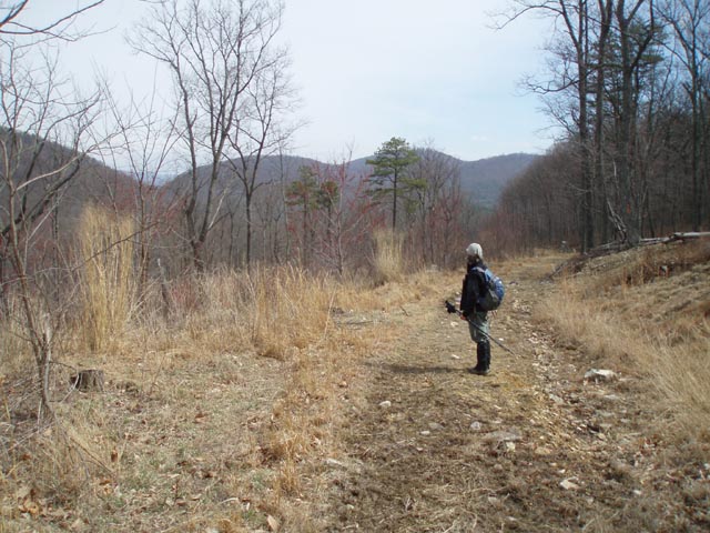
comment: Got to
give this hike a high 4 rating just for the diversity. Start
out passing open fields and views to the north before
descending into the first of two valleys and a wonderful hike
along Halfmoon Run. After climbing the only really strenuous
section of the route, the German Wilson Trail, reach the top
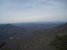
of Halfmoon Mountain and enjoy the best vista of the entire
Trout Run Valley with views of Big Schloss, Tibbet Knob and
Great North Mountain. On the way back down, the abundance of
Laurel on Halfmoon Trail should be spectacular in June. Have
to thank MRHyker here for recommending this
one!
________________________________________ |