MD Hikes

PA Hikes

VA Hikes

WV Hikes

Hike Schedule

Gear/Tips

Trip Archives

Flora & Fauna

Recent Critiques

Desk Tops

Hiking Links

Hall of Fame

Restaurants

Trail Blockage Report

  Contact Us  


Last Updated: 10/18/08  


 Welcome to a web site full of information on hiking in the Mid-Atlantic Region (PA, MD, VA and WV) ... topo maps, 3-D maps, elevation profiles, GPS data, directions, trail notes, photos.... everything you need to prepare for an excursion into the wilderness. Information for 170 hikes and over 2003 trail miles are now available. Venues such as, but not limited to, Shenandoah National Park/VA,  George Washington and Jefferson National Forests, VA and WV, the Monongahela National Forest in WV, state forests throughout PA, Green Ridge State Forest in MD and regional, state, county and federal parks throughout the Mid-Atlantic region are represented.


"Do not go where the path may lead. Go instead where there is no path and leave a trail." - Ralph Waldo Emerson

Bulletin Board


Hike schedule update: The schedule now runs through 01-01-2009.

__________________________________________________________________________


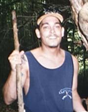
In Memoriam: Steve C. MacNaught and his friend, Victor Klein were among the very first hikers to ever put their faith in me when I first began leading outings in the 90s. This photo is from a1998 Catoctin Mountain hike. "Steve loved nature, supported the wolves of Yellowstone and many other charities and thoroughly enjoyed the hikes we were able to participate with you." Victor told me in a recent E-mail. Unknowing to many, Steve suffered from a very painful and debilitating disease, Ankylosing Spondylitus. He still managed to enjoy the great outdoors as long as his body would let him. Steve passed away on April 12, 2008, at the tender age of 41 from complications of his disease. Now he is hiking painlessly in the ultimate forest. Those who knew Stevie Mac and his humor will surely miss him. I know I will.


__________________________________________________________________________


Latest Published Hikes


Riprap Hollow Loop, VA

Turk Mountain Cirduit, VA

Blue Ridge Center for Environmental Stewardship, VA

Austin Mountain-Furnace Mountain Loop, VA

Berma Road - C&O Canal Towpath, MD

___________________________________________________


M. R. Hyker's Latest Adventure(s)


More Photos to Come


10-10 to 12-2008, Quehanna Wild Area –SE: Eight of us caravanned up from the Baltimore area arriving at the Sinnemahoning Road/Tr trailhead off of Three Runs Road around noon. I was joined by Shortstack, Jody, Indiana Moser, Cognac Jack, Moonshine, Dimitri and Chris. The weather was perfect for the entire trip and the fall colors were in their prime. The first day included hiking Big Spring Draft trail, a part of Wykoff trail, Bellefonte Posse trail and the Meeker trail stopping for the night near its junction with the QTCC. We set up camp in a deep grove of Hemlock and Spruce. A group of three backpackers had taken the small site with the fire ring but offered to share it with us. During our fireside discussion one of them pulled out a map from my website. They were a bit surprised to find themselves talking to the Webmaster.

The sleeping that night was excellent. The next morning, however, was a bit disappointing. We were rudely awaked by the sound of heavy construction equipment at 6:30. Initially it sounded like it was coming from the other side of the hill and was not that far away but as I walked around I could better discern that it was coming from the Quehanna Highway. The sounds were relentless.

In no time everyone was up, eating and breaking camp so we could get away from the noise. This leg of the trip included hiking the QTCC south to the QT proper. (We passed an old pumping station that used to send cooling water to the nuclear reactor along Meeker Run. Following the last mile of the connector was a bit rough to follow. It was a trail by name only. I alerted everyone to keep an eye out for the blue blazes. We eventually made it to the connection with the QT but it took us one hour to travel one mile. In the future I think I’ll follow Pat’s recommendation and stay on Lost Run Road for that segment. Once on the top the hiking was nearly flat for quite a stretch as we hiked eastward on the QT. We took in the three or so vistas including Wild Cat Rocks and a nice southerly view across another drainage. The descent back down to the next valley was steeper than the initial ascent but we all made it down O.K. We took a brake at the hunter’s cabin and refilled our water bottles before crossing that fantastic new footbridge over Mosquito Creek. As we approached Corporation Dam the trail made a hard left and followed a small drainage up a hollow before making another sharp turn to climb to an old grade. I struggled on that segment but was able to recover at the small vista at the top. From there the hike to our next campsite was easy. We arrived at a nice spot w/fire ring near the fork of two streams near an area called Fisher Rocks. The valley was filled with a sea of crimson Blueberry bushes. (Thanks George and Pat for the info!). We set up camp and began preparing our dinner as the sun set and the full moon rose. It was pretty neat.

The next morning I studied the map and decided to shorten the trip a tad. I had advertised that the hike was going to be 28 miles in length. After re-evaluating the GPS data I had obtained up to that point I realized that it was going to be over 30 miles and include another nice climb. Everyone was in agreement. We did our usual breakfast and breakdown routine and continued north on the QT. As we hiked along the right fork of the stream we found Pat’s campsite on top of a hill to our left. We will definitely use that one the next time. Just before crossing the Quehanna Highway we passed yet another ocean of crimson bushes surrounded by other fall colors and on the other side of the highway we were met by fields of golden ferns with backdrops of yellow and orange trees. I can’t quite remember exactly where without looking at a map but at one point we walked through an almost clear-cut area that offered a nice view down a valley with other mountains in the distance. We descended to a gravel road that services the Piper Reservoir, crossed a stream and made our last climb of the circuit. This one was also pretty hard on me but for some reason I was feeling better as I reached the top. After another break at a small vista we proceed north until we reached Three Run Tower Road. This is where we modified the hike. After exploring the ruins of the old tower for a while we took the Tower Road back to Three Runs Road and our vehicles. We were finished by a little after 2:00 and had completed 30.2 miles.


________________________________________________________________________________________________
 

Latest Outing Critiques

Name: Brad                                                                                                 Hike: Hog Camp Gap - Reeds Gap Shuttle (modified)
Date: 10/10-10/12/2008                                                                                         Rating: 5

Critique: Started this hike on Friday evening at Hog Camp Gap after sunset. Hiked up the Tar Jacket Ridge in the dark and made camp at the top. It was a cold and windy night, but very clear with a bright moon.

The next day we awoke at sunrise and got warm by the fire, ate some food, and then headed northward. Many great vistas along this stretch of the trail and overall this part of the hike was not too difficult with gradual ascents and descents. The fall colors had begun to show on many of the trees and temperatures were in the 70s with bright sunshine. We did see a bear about a mile before crossing the North Fork. It took off running from the left side of the trail; not full-sized but not a cub either. We stopped by the Seeley-Woodworth shelter and took a break for lunch. We then continued northward. Beware of the yellow jackets about a half mile beyond the shelter heading northward! There are several nests in the ground around a stretch of the trail that goes through a small grove of apple trees. We had to walk quickly through this area to avoid being stung.

We then continued on and made camp at Spy Rock. A few others were camping at the campsite below us, but we actually made camp up on the rock and had a good fire going to stay warm. It became very windy and cold up here at night. Some of the other hikers came and hung out around our fire for a while. The sunset, and sunrise the next morning, at Spy Rock were amazing! This has to be one of the best vistas I have ever seen!

After getting warmed up in the morning by the fire, we continued northward on the AT and climbed over Maintop Mountain and then continued toward the Priest. The climb up the Priest from Crabtree Road was the hardest part of this trek so far, but still much easier than climbing up the Priest from Rt. 56 would be. We stopped at the top of the Priest for lunch and enjoyed the overview to the west from boulders to the left side of the trail.

We then began the steep descent of the Priest which became difficult for me after pulling a tendon in my left knee earlier in the day on some rocks. We had left our second vehicle at the parking area by the Tye River and not at Reed's Gap as we had decided that we may not want to do Chimney Rock based on time restrictions. By the time I got to the base of the Priest I could not bend my left leg, so we decided we made a smart move in leaving the truck here.

Overall this hike was a 5 for the views and the overall scenery of the woods. Spy Rock and the Priest were the highlights of this hike for me and I plan to complete the last portion of this hike at a later time.

________________________________________________________________________________________________

Name: Marty                                                                                                                Hike: Patapsco Valley SP
Date: 10-04-2008                                                                                                       Rating: 4

Critique: The State Park is heavily wooded with lots of trails with a mixture of streams, forest, pasture and respectable hills. It's easy to get to, but the drawback is that there are lots of people hiking and biking - not enough to be truly annoying, but you are never totally alone.

We picked the area because our son is going to the Naval Academy and is severely limited in the range he is allowed to travel. We were pleasantly surprised at the area, which was especially nice in fall weather, and will go back. Even better, entrance to park is free for parties with service people.

We didn't have much difficulty following the trails although they could be better marked.

________________________________________________________________________________________________

Name: Leslie Ann Jones, DVM                                                                                   Hike: Mount Pleasant Loop
Date: 10/4/08                                                                                                             Rating: 4

Critique: Wonderful, but a bit challenging. We really enjoyed the Mount Pleasant 6+ mile loop, however, we found out the hard way that the road from 60 that should take us up to the trail head (North Fork Road- VA Rte 635) has been washed out about 4 miles up. That left us to hike in an additional 2.5 miles to just get to the trail head! Now that we've done some serious Google-Earthing of the region and the topography, I think we have figured out how to get to the trail head off Wiggins Road, but DON'T try to get to the trail head from North Fork Road, as what should have been about a 3-4 hr hike was the bulk of 6 hrs and we almost got lost after dark! yikes!

Looking forward to trying some more of these hikes soon, but need to recover from Saturday first!

________________________________________________________________________________________________

Name: John S                                                                                                               Hike: Mt. Pleasant Loop
Date: 9/27-9/28/08                                                                                                  Rating: 5+

Critique: An absolutely fantastic, excellent hike. I think Mt. Pleasant might have the best vistas of any hike I've done to date. I believe it blows other hikes I've done, i.e. Gregory Bald and Mt. Cammerer (in the Smokies), out of the water, and it's a much easier, more rewarding hike. I'd highly suggest this hike for those fellow backpackers who find it impossible to get a significant other to tag along or find it hard to find a nice hike because of their dogs; it's not terribly difficult (but no spring chicken) and it's incredibly rewarding. Hike this one as suggested - starting towards Pompey mountain first. Once you head down Mt. Pleasant, you'll understand why - the trail is pretty demanding in the opposite direction.

I would highly suggest that anyone wishing to do this hike consider doing it as an overnight. It is short, but there are at least four EXCELLENT campsites at the summit of Mt. Pleasant. The trail summary here and on hikingupward.com make it seem as if there is only one campsite at the summit, but there are indeed four! Some reviews have said that the campsite along the sister hike to Mt. Pleasant, Cold Mountain, is the best site in GWNF, but I think I disagree. We stayed at an awesome site just below the east vista. There were two sites near the west vista and two near the east vista. All sites had their own fire pit, and enough room for a 2/3 person tent + fly.

When the weather finally cooperated, the vistas were amazing. The west vista is slightly better, but the sunrise can only be seen from the east vista, and it was fantastic. Make sure to see all of the west vista, as there are a couple extra trails in the area to other rock vistas. The east vista is about 180° and the west vista is about 270°. There is plenty of room at both vistas for people and animals - it is impossible to hog these vistas (contrary to the other review) so don't worry about this. The only better vista I can remember better than this one might be atop Flat Top at the Peaks of Otter (and only because it is 360°). Again, I can't express the beauty of the vistas, they were fantastic. I am a backpacker/hiker that enjoys mountain hikes to good vistas, and this one is the cream of the crop!

________________________________________________________________________________________________

Name: Matt                                                                                                                  Hike: Laurel Fork
Date: 9/20/2008                                                                                                         Rating: 4

Critique: Great hike. The last part on Buck Run is challenging but really nice with the beaver pond and the Red Spruce stand. The fords of Laurel Run provide some great options for camping.

________________________________________________________________________________________________

View All Critiques