|
Laurel Fork Wilderness-Allegheny Trail Shuttle/Loop |
|
|
Description:
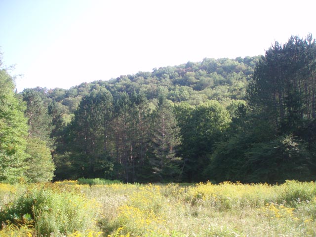
The Monongahela's Laurel Forks Wilderness is one of the least
visited of that forest's Wilderness areas and is located in the
northern reaches of the Greenbrier Ranger District. While it
cannot boast of grandiose vistas or fantastic waterfalls, it
provides the hiker with beautiful views of the Laurel River and
the meadows in its surrounding valley while using the ridges of
Middle Mountain as a backdrop. One thing it is definitely loaded
with is SOLITUDE!!! Probably one preconceived drawback is the notion that you can only do shuttle or out-and-back hikes on a limited number of trails within the Wilderness Area. We felt that way as well until we realized that there are two trails that connect or almost connect the LFW with the Allegheny Trail in the Glady Fork Valley to the west. This allows one to hike either a 27.2 mile moderate "Horseshoe Shuttle" or a 30 mile loop (if you don't mind walking 2.7 miles on CO 27). To add to the beauty of the trek is a three mile walk along the West Fork Rail Trail with all of its pastoral views, an amazing two mile walk through a dense Hemlock forest on the McCray Run Tr ( I've never seen so many living Hemlock trees in one place.) and an equally appealing hike along Glady Fork on the Allegheny Tr. Most climbs and descents are gradual except in a couple of places. |
|
Tread is pretty good along most of the route. In a few places the Laurel River-North Trail can be lost in the meadows it crosses but is not as bad as it might appear. These Trail Notes will show you the way. Custom Google Directions to Hike End if Doing the Shuttle There is a large parking area w/kiosk on the left side of CO27. Google Custom Directions to the West Fork Tail Trailhead ________________________________________ |
|
Printable/Downloadable Map (11X17) Zipped National Geographic. TOPO! GPS and Universal GPX Files |
Trail Notes: The portion of the West Fork Rail Trail used here is part of the Allegheny Trail. You will see yellow blazes on the gates you pass through/around. The High Falls Tr, Beuhla - West Tr and the footpath portion of the McCray Run Tr are blazed with blue plastic diamonds. The easternmost/service road section of the McCray Run Trail is note blazed but is signed at its terminus. There are a few sporadic blue diamond blazes on the Laurel River - North Trail outside the Wilderness. All trails within the LFW are not blazed (shown as red on the map) but are signed at the junctions with trail numbers. Safety Notes: The West Fork Rail Trail is mostly open to the sun. Dress accordingly and bring the sun block! The one ford of the Laurel River may be difficult to locate because of high weeds on the opposite bank. It can also be dangerous or impossible to cross during periods of high water. Consider this before departing on this trip. Day 1 (9.2 miles): This day has the most elevation change.Starting at the West Fork Rail Trailhead (TR312) proceed south. Make sure you lock the gate behind you in case farmers are moving livestock from one pasture to another. Follow the Rail Trail for 3.19 miles and turn left onto the High Falls Trail (TR345). There is a sign on the right side of the rail trail. Hike through a meadow and into the woods. Cross Glady Fork on a recently constructed wooden bridge. In o.41 miles from leaving the rail trail arrive at FR44. Turn left on FR44 and walk approximately 0.49 miles to the western terminus of the signed and blazed Beulah Tr (TR310) on the right. Turn right and climb up along a small drainage. |
|
In 1.21 miles arrive at a gas line service road. Turn left and descend until you see a Gas Well straight ahead. Without passing the well make a hard right on a dogleg of the road. Descend further, passing another gas well. The road will then turn sharply to the left crossing a small tributary at 0.8 miles from the upper gas well. The road will continue to turn to the left, crossing over the East Branch of Glady Fork on two large culverts. You'll also pass two dirt/gravel roads on the right. In 0.23 miles after crossing the fork turn right onto the signed continuation of the Beulah Tr. The initial climb will be gradual but gets steeper as it approaches FR14. Cross FR14 and pickup Beulah Tr - East. It is not blazed but pretty easy to follow. It starts as a footpath but climbs up to a railroad grade after crossing a stream. The RR grade merges with the Laurel River - South Tr (TR306) at a sign post. Turn left (north), cross the feeder stream and climb up to a section of side-hill trail. Eventually the trail will descend and join another RR grade. (Watch for reroutes. Since power tools are not allowed in Wilderness areas trails are often moved around serious blowdowns instead of removing the obstacle.) You will pass a nice Hemlock grove on the right. This would make a good campsite. There is no fire ring. In 0.56 miles from first joining the Laurel River Tr arrive at the primary campsite. It is on the other side of the river. It has a fire ring and can hold several tents. If this spot is taken there is yet another good spot a mere 0.07 miles further down the trail but it also has no fire ring. Day Two (9.1 miles): This is the flattest part of the trek but probably the most technical. The challenges are in bushwhacking where the trail disappears in the meadows and possibly the one ford of Laurel River. From camp continue south on the Laurel River - South Tr. The trail follows the edge of a small, pretty meadow before joining another RR grade. Here the Forks Trail (FR323) comes in on the left. The trail then descends to another meadow (Note the enclosed piped spring to the left) and passes a register box before arriving at the southern end of the Laurel Fork Campground. There are two newly constructed latrines here. Follow the campground loop road out to FR40. Turn right, crossing the river, and then left into the north section of the campground. Follow the loop road around to a kiosk at the apex of the loop to pick up the Laurel River - North Trail. The trail follows a railroad grade a short distance before climbing up to a meadow and a junction with another RR grade (It's impossible to tell at this point that it is an RR grade ... but it is.). There is a register box here. Turn left and follow the edge of the meadow and cross Five Lick Run. Soon arrive at a blowout of the grade. Climb down to the edge of the river and rockhop to the continuation of the grade (about 30 feet). The grade then veers away from the river to the right into a grassy area in the woods. Bear right onto a well defined woods road. It will climb about 50 feet before leveling off. In 0.64 miles the road rejoins the RR grade. It will do this several times through the course of the day. I marked some of them on the map but may have missed others. A general rule of thumb here: if given the option of following the RR grade or taking the high road to the right of the grade, take the road. The grade is probably very overgrown or a blowout has made it impassable in these sections. In 1.19 miles from where the last RR grade/road merge is shown on the map arrive at a large cairn. The road bears to the right and the grade continues straight into a huge meadow. Both seem to peter out almost immediately. It does not matter much which one you take. The focus should be on crossing Adamson Run which is right in front of you in both cases. Cross the stream and turn downstream (towards the river) and follow the stream until you find some cairns marking the way. You'll see a small campsite along the tributary. The route roughly follows the edge between the meadow and the wooded hillside. You will also pass a couple of old, bottomless galvanized washtubs that we placed there as cairns. They were probably left there during the logging days. You will soon regain the RR grade. Continue north on the Laurel River - North Trail. You will encounter two other bushwhacking opportunities in another 1.78 miles and then in another 1.13 miles further. Neither of these are of the degree as the initial one. Simply cross the feeder stream at the closest point to you and follow the edge between the meadow and the woods always heading downstream relative to the main river. In 0.43 miles from the last bushwhack arrive at a RR grade (straight ahead) and road (slightly to the right and rising) option. They both go to the same gas pipeline swath. I recommend you take the road. In 0.80 miles it curves away from the river and merges with a gas pipeline road, passing a fallen wilderness sign just before the merge. Follow the road uphill. It will bear to the left and re-enter the woods in 0.23 miles. In 0.34 miles the road will descend to the RR grade but just for a bit before climbing and descending quickly to the grade again. As you look up the grade here you'll see logs across the grade. There must be a blowout along that section. In 0.39 miles from this merge the grade simply stops. This bushwhack is unlike the others. There is no stream to ford or edge to follow. Simply plow straight ahead while staying parallel to the river. When you re-enter the woods on the other side search for a faint footpath in the short grass. The trail parallels the river for another 0.22 miles. Continue to go straight as the river doglegs to the right and towards you. When you reach the bank in a nice Hemlock grove look across the river. You'll see four Hawthorn trees in a line along the opposite bank. The one furthest upstream is separated from the others. Follow the bank down until you are directly across from the next tree. If the water is low you will see a ripple going on a diagonal across and down the stream. This is the shallowest section. Cross the river following this ripple, ending roughly at the last Hawthorn tree in the line. Bushwhack around the Hawthorn tree and through the brush. Look for a fallen tree on the edge of the woods and head for it. The trail begins again at a tree marked with a blue plastic diamond. The trail is a bit difficult to follow here because of a few blowdowns but the woods is otherwise open. Roughly parallel the river until you arrive at a splendid campsite with fire ring shaded by magnificent Hemlocks. You made it! Day Three (9.0 miles if doing the shuttle, 11.7 miles if doing a loop): You will be doing some climbing today but it will be pretty modest and short-lived. You'll also not be bushwhacking. The trails are either obvious or well marked. The Laurel River Trail continues in the northwest corner of camp, near a huge fallen tree. Follow it through a grassy area and then briefly along another RR grade. It will curve away from the river and begin to follow the Beaver Dam Run drainage. At about 0.21 miles the RR grade will be blocked by a couple of logs and a cairn. turn left onto a footpath hill and follow it for 0.85 miles. Climb steeply to an old woods road. Turn right here and follow it for 0.40 miles to FR14. Watch for nice views of the drainage to your right. Turn right onto FR14, cross Beaver Dam Run on a bridge and then turn left onto the McCray Run Trail (TR302). It is a gated service road at this point. Follow the service road for 1.2 miles where you will find another trail post at an old woods road on the right. Turn here. For the rest of the hike you will be on blazed trails. Here you will again begin to see more and more Hemlocks. At 0.44 miles from the service road the trail abruptly turns left onto a footpath which crosses a grassy area. There are 2 or 3 potential campsites along this section of the trail. In o.5 miles from leaving the old woods road cross a grassy pipeline swath and soon enter a magnificent Hemlock forest. Follow the blue blazes for another 1.36 miles to the junction of the Allegheny Trail (TR701). Turn left onto the Allegheny Trail. There are some excellent swimming/fishing holes between here and the crossing. For the next 0.41 miles the trail will be dual blazed (blue and yellow). The McCray Run trail then turns to the right and fords Glady Fork. Stay straight on the now yellow blazed Allegheny Tr. Most of this trail follows old railroad grades except in 2 places where the grade was washed away by the flooding stream. At these points the trail will climb steeply, high above the fork and follow a rocky side-hill trail. In 2.67 miles after the McCray Run Tr turn off arrive at the crossing. One used to have to wade across here but the Forest Service recently constructed a nice steel and wood bridge. After crossing the fork continue to follow the yellow blazes as the trail climbs out of the valley. In 0.78 miles arrive at CO27. If you planted a car here you are finished hiking. If not turn left onto CO27 and follow the signs back to the starting trailhead (2.7 miles).
Printable/Downloadable Trail Notes ________________________________________
________________________________________ Outing Critiques Name: Moonshine Hike: Laurel Fork Wilderness-Allegheny Trail Date(s): 08/31 to 09/02/13 Rating: 4
Critique: I added an out-and-back to High Falls on Day 1. After recent rains the waterfall was spectacular. The trail over Shavers Mtn is rocky and washed out in some spots. Laurel Fork Tr North of the campground is overgrown with weeds in many places, but tall cairn don't let you get lost. North of the Wilderness boundary new blue diamonds guide you to the ford and all the way to FR44. Now, the really important issue: McCray Run Tr has lots of blowdowns. They are so bad that I chose to walk the creekbed wherever possible. Allegheny Tr is not much better for the first 0.5 mi. Overall, I made about 37 mi in 2.5 days and capped the trip with a refreshing dip in the river in Glady. _______________________________________ |
|
|