| Martin Hill Wild Area-South |
|
|
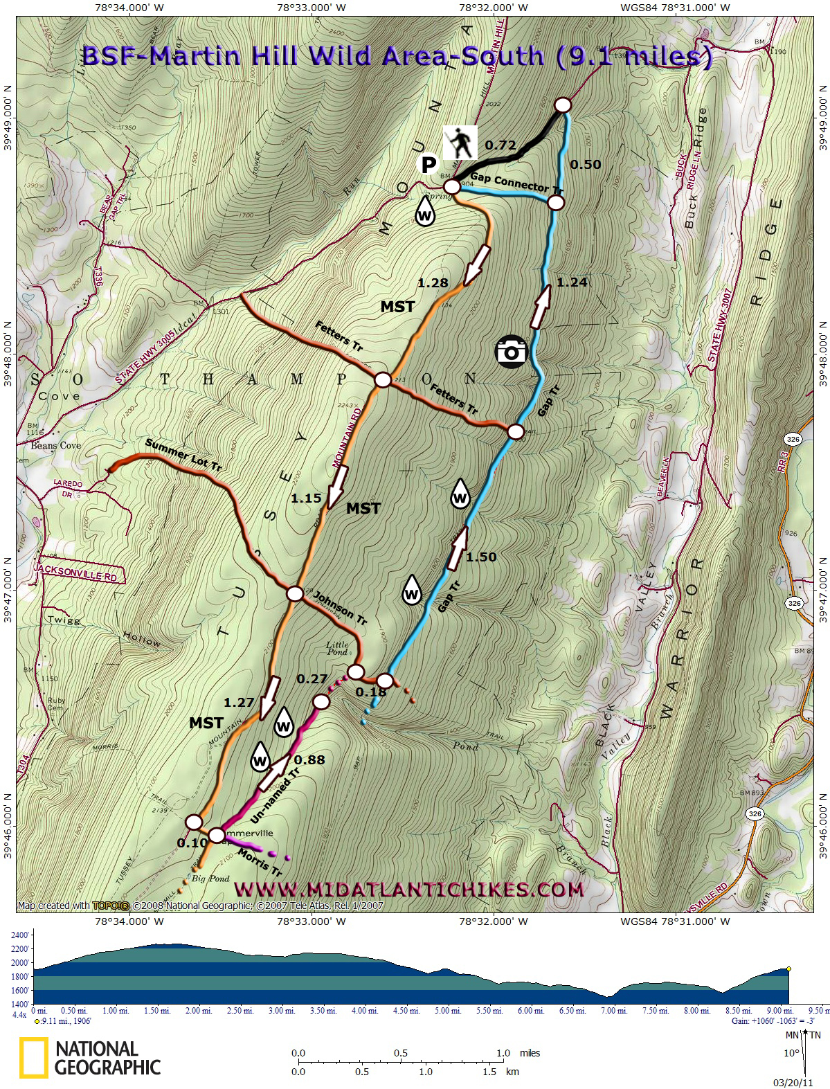
Description: The Martin Hill Wild Area is comprised of 11.500 acres of Buchanan State Forest. The southernmost part of the Mid State Trail (MST) runs right through it. Using it as the backbone, some side trails and perhaps a little bit of bushwhacking some pretty nice loops can be made.
Described here is a generally moderate 9.1 mile circuit. The first four miles are an easy road walk while the remaining 5 miles are much more challenging, utilizing an abandoned but scenic trail and a 0.3 mile bushwhack. Google Maps Custom Driving Directions The hike starts at the parking area on the top of Tussey Mountain on Beans Gap Road. The Mid State trail is part of the Great Eastern Trail (GET). |
|
________________________________________ |
Zipped National Geographic TOPO! GPS and Universal GPX Files |
Trail Notes: From the parking lot cross the road and walk around the gate blocking an old road (formerly Tussey Mountain Road now the MST). It also serves as a cross country ski trail. Immediately pass the Gap Connector Trail on the left. This will be your return route should you be able to find the other end. Pass Fetters Trail, both on the left and right, in another 1.28 miles. The junction of the Summer Lot Trail (right) and Johnson Trail (left) is in another 1.15 miles. (If you wish to do a shorter hike, avoiding the bushwhack, you can turn left here and pickup these notes later.) The MST leaves the road, turning left, at the Morris Trail in 1.27 miles from the previous trail junction. In 0.1 miles the MST turns right and a continuation of the purple blazed Morris Trail is straight ahead. (It reaches a dead end about 200 feet from the Gap Trail.) Take neither. Instead, turn left onto an un-named trail. As of this posting the way is marked with pink Surveyor�s tape tied on trees. It will eventually deteriorate and fall of. The trail can also be followed by watching for old cut logs that had fallen across the trail years ago. In the spring Pond Branch flows with that pleasant gurgling sound that is so soothing to one�s ears. You�ll cross the stream a couple of times and you should be able to find some springs bubbling up from the ground on your left. In 0.88 miles the trail and the surveyor�s tape stops as the stream makes a hard right to descend through a deep, narrow gorge. This is where the bushwhack starts. Continue straight ahead following the side of the mountain at a nearly constant elevation, dodging thickets, blowdowns and rocky areas as best you can. You can drift to the left or the right a little. In 0.27 miles from where the stream changed directions arrive at a mossy woods road. This is the Johnson Trail you had passed while hiking the MST earlier. Turn right and descend to the blue blazed Gap Trail. Turn left onto it. Initially you will have to negotiate some bad blowdowns but the trail conditions improve with time. Over the next 1.50 miles you will descend down into a couple of drainages with short but steep climbs up the other side. Pass Fetters Trail junction. Shortly after that the trail climbs up to a cliff area and skirts private property. Here you will get wide open views of Black Valley, Warrior Ridge and Polish Mountain until the trail reenters the wood. In 1.24 miles from the last junction you �should� arrive at the junction with the Gap Connector Trail. There is no sign and it is difficult to locate. If you do, turn left and follow it up to the MST Trail, saving approximately 0.7 miles. If you cannot locate it simply continue on the Gap Trail until you reach Beans Gap Road and turn left onto it, following it back to your vehicle. |
|
____________________________________
________________________________________ |
|
|