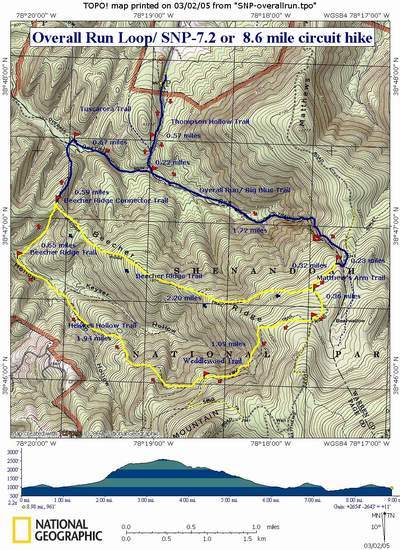
Trail Notes: From the parking area, walk south along the driveway. Pass one drive on your right. Shortly come to blue-blazed Thompson Hollow trail and the park boundary on your right.
Turn right onto this footpath. Pass blue-blazed Tuscarora Trail on your right at about 0.6 miles. The Tuscarora will share the trail to above the Falls before you leave it. In about 0.2 more miles reach the junction of the blue-blazed Overall Run/Tuscarora Trail.
Turn left and proceed up the Run, crossing it twice. In one mile from the last trail junction begin climbing steeply along switchbacks to the top of Overall Falls. Besides the falls, sweeping views of Massanutten Mountain to the west are offered.
Continue upward passing the continuation of yellow-blazed Matthews Arm trail on the left. In about 100 yards the Tuscarora Trail will go to the left. Bear to the right here, staying on Matthew's Arm Trail (yellow-blazed) for another 0.3 miles when you will come to yellow-blazed Beecher's Ridge Trail. Follow either 7.2 or 8.6 mile option from HERE!
7.2 mile option:
Turn right onto yellow-blazed Beecher Ridge Trail. Descend for 2.2 miles to blue-blazed Beecher Ridge-Overall Run Connector Trail.
Bear right onto the connector trail and follow it to Overall Run. The stream splits apart here so 2 or 3 crossings might be necessary to reach the blue-blazed Overall Run Trail on the other side.
Turn right on the Overall Run Trail. Climb gradually, passing some small falls and a swimming hole on your right, just before coming to Thompson Hollow Trail. Turn left onto Thompson Hollow Trail and follow it out to your vehicles.
8.6 mile option:
Pass Beecher Ridge Trail and stay on Matthew's Arm Trail for another 0.4 miles. Turn right onto yellow-blazed Weedlewood Trail.
In 1.1 mile turn right onto yellow-blazed Heiskell Hollow Trail and descend to the intersection with yellow-blazed Beecher Ridge Trail.
Turn right onto the Beecher Ridge Trail and ascend to the crest of the hill.
At the junction with the blue-blazed Beecher Ridge-Overerall Run connector trail turn left and follow the remainder of the directions for the shorter version.


