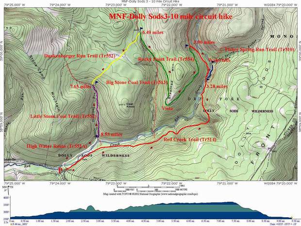
Trail Notes: Before starting, take note that there are no blazes in Dolly Sods. Recently, sign posts have been re-installed at all trail intersections. Ive done this easily as a day trip. Fulya and I did it 2 days after Hurricane Isabel. I knew the water was going to be high so we opted to do the hike in the reverse direction using an old high water route described at the end to avoid the worst stream crossing. It took us a little over 7 hours because we did a lot of bushwhacking to some cool waterfalls and the Lions Head Overlook. Having not been to the latter it took us a while to find the easy passage up. There is so much to explore here and there is such an abundance of good campsites around that a backpacking trip might be the preferred way to go.
From the parking area, walk up Red Creek Trail. It begins as a wide forest road which stops at a stream crossing of a small tributary. Cross the stream and immediately turn right on a narrow footpath, following close to the bank. Part of the trail has been blown out. This area will become apparent to you shortly. Bushwhack through this area and pick up a well-defined footpath on the other side. Follow it to a grassy clearing with a trail that comes in on the left. This is Little Stone Coal Trail. The sign is there but I believe closer to the creek. You may want to take the short trip out to the crossing to examine the ford for your return trip. If it looks too risky there is an alternate return route that will be described later.
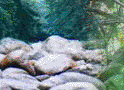
Return to Red Creek Trail and proceed upstream, climbing gradually. At about 1.5 miles, watch for a severe blowout of the bank on your left. Just beyond this point a cairn will mark the spot where you should turn left and scramble steeply down the hill to a grassy area beside Red Creek . This is is a popular campsite. The trail restarts here. Shortly another trail will come in from your left. This is the juncture with Big Stone Coal. There are some great falls on the other side but you have to bushwhack up them since Big Stone Coal Trail rises some 50-100 feet above the stream.
Continue straight up Red Creek Trail. Because of severe rearrangement of the bank from recent storms . the trail has been moved farther up onto the hill. Wind in an out of three steep coves. The back of each one has its own nice waterfall during the spring and after heavy rains.
2 miles after the last trail junction, pass Fisher Spring Run Trail on your right and descend to the first ford of Red Creek. If you are backpacking and want to set up camp or are ready for a break dont cross. There is an ill-defined trail that follows the Creek a bit further, ending at a great campsite/lunch spot beside a 8 foot waterfall that stretches all the way across Red Creek. If you are wearing the appropriate footwear, a bushwhack up the Creek a short distance will bring you to some nice falls on Fisher Spring Run.
After your break, return to the crossing (marked with cairns), don the footwear of your choice and cross Red Creek. There is another good campsite on a bench sitting above the creek here and another one just a little further up the trail almost directly across from your lunch spot.
Continue up Red Creek trail as it climbs to a junction with Rocky Point Trail. Turn left onto Rocky Point. The last time I traveled it, the initial part was severely littered with blow-downs. Soon the trail will become quite rocky as it becomes apparent that you are walking on an old railroad grade with the ballast still there.
Pass several small Cairns on your right with hints of trails going up to the Lions Head. These are all difficult routes in comparison to the easy route. Ignore them. For a bit you will find the path devoid of trees. At this point you are almost directly under the Lions Head. The trail will gradually turn north, paralleling the Big Stone Coal Drainage. As you begin to re-enter the woods watch for a cairn on your right with a well-worn footpath behind it. This trail ascends through a pine grove often used by campers. You may want to drop your packs here and bring your camera, water and snacks for the rest of this side trip. The trail weaves steeply, first through vegetation and then rocks. Cairns mark the way. Climb up through a fissure in the rocks to the top. Follow the cairns on your left out to the edge to a grandstand view of the entire Red Creek Drainage. The Lion's head is to your right.
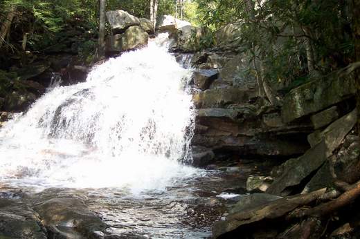
Return to Rocky Point Trail, recovering your gear along the way, and turn right. Rocky Point Trail ends at its juncture with Big Stone Coal Trail. Continue upward on Big Stone Coal Trail. Soon you will here a waterfall. Its the one shown on this page. If you desire, drop your gear and bushwhack down for a great photo op. Note: the walls of the gorge are steep and slippery so take care!
Continue up Big Stone Coal Trail, descending to cross Stone Coal Run at about 0.5 miles from the previous trail junction. Travel a short distance up Stone Coal Trail to the intersection with Dunkenbarger Trail.
Turn left on Dunkenbarger Trail. In about 0.3 miles come to Dunkenbarger Run and a great campsite along the run . (I think there is a beer commercial about this place.) There is more camping on the other side and to the left, a short distance down stream. Cross Dunkenbarger Run and travel approximately 0.6 miles to the junction of Little Stone Coal Trail.
Turn left and descend rapidly along Little Stone Coal Trail as you get glimpses of the waterfalls to your right. Bushwhack to some of them at your own risk and enjoyment. The really big one that Fulya is standing in front of on the Sierra Club website is about 1/3 of the way down.
In about 0.8 miles reach Red Creek. If the stream is fordable, cross it and locate the cairns on the other side marking the trail you checked out earlier. From here simply retrace your steps back to the car. If the ford looks too risky, take the following high water route. Note: some bushwhacking is required.
High water route from Little Stone Coal Run: Walk downstream from the ford. Sometimes you may be able to walk along the rocky bank. Cross what appears to be a stream. Actually it is a backwater of Red Creek. Shortly pass this point probe the brush for access to what appears to be an old overgrown road leading generally down stream. Eventually this will bear away from the creek and stop in a marshy area near a beaver dam that blocks the previously described backwater. If you look out beyond the backwater, over the beaver dam, you may spot an old forest road going up the side of the hill. This is the continuation of the road you are on. If you cannot easily make your way to it from the marshy area regain the creek bank as quickly as possible. Walk down the bank, searching the opposite shore for the confluence of that first stream you crossed in the morning. When you find it turn your back on Red Creek and bushwhack in a northerly direction through some relatively open woods, crossing the backwater at a more manageable point and climbing steeply to gain the old forest road. Walk up the road keeping an eye out to the left for a well worn but narrow footpath. Follow it steeply down to the old steel bridge on Rt 42 which you drove acros enroute to the trailhead in the morning. Cross the bridge and walk back to your car.