| Morgan Run N.E.A. |
|
Description: Located in Carroll County, the Morgan Run N.E.A. is comprised of approximately 1400 acres of natural area. Hiking and equestrian trails are popular. I had read about hikes in this venue in two old books. Neither seemed that appealing to me since they were mostly on wide grassy equestrian trails called �cuts�, short and constantly exposed to the sun. The more I tried to correlate what the authors were talking about with my mapping software the more I got a sense that one could plot a nice hike that was at least half in the woods and followed pretty streams.
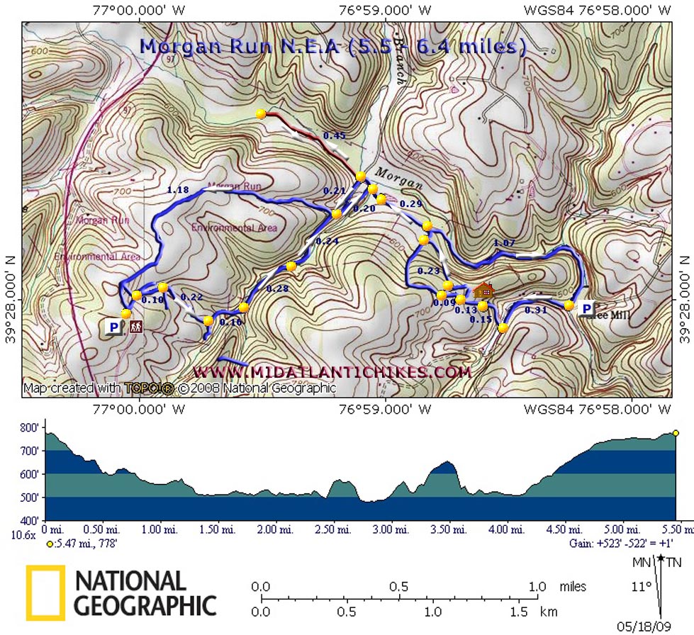
Described here is a 5.5 mile �dumbbell� hike with an optional 0.9 mile out-and-back segment. Looking at the short distance and 700 feet of elevation gain one might want to give this one and easy rating. Keeping in mind that the trails are not signed, blazed or maintained (except for occasional mowing of the �cuts�), I have to give this one a moderate rating. All but a few of the trail blockages are easy to negotiate as of this posting but that is subject to change with the next storm. The only down side is a 0.45 mile road walk to close the loop.
|
|
The highlights of this hike are a walk along a pretty little stream with a wide variety of spring wild flowers along the trail, some industrial history as you pass some farm buildings, a nice vernal pond, the beautiful Morgan Run and walking across the large expansive open area. This is a great birding spot as a literal host of song birds live here and feed among the ever invasive Fall (Russian) Olives.
Google Custom Driving Directions ________________________________________ |
|
|
Trail Notes: From the kiosk take the cut to the right that descends downhill to a picnic table and a four way intersection of cuts. Take the one most to the right. Follow the left edge. In about 0.1 miles a single track trail will bear to the left. Take it and follow the left edge of a clearing for 0.22 miles to another single track trail on the left. Follow it as it descends into the woods for 0.16 miles.
The trail seems to disappear here. Cross a very wet seep that parallels the small stream to your left and pass a large root ball from a fallen tree on your right. At this point the trail reappears. Cross 2 small streams and climb over a large fallen tree to find yourself standing on a nice woods road. Follow it for 0.28 miles. The blue blazes to the right denote private property. Please respect the landowner�s rights and stay on the trail! Cross the stream and climb gradually for 0.24 miles to the top of a hill. To the left is an old farm road (which you�ll use in the final leg of the hike) and 2 metal sheds. Don�t go that way but turn right. Pass the ruins of an old barn. The trail will split immediately after that. Bear right, passing a corn silo on the left.
In another 0.2 miles turn right onto a footpath and immediately cross the stream you were following earlier. As you enter another opening look for a side trail to the left that will take you to a pleasant pond. Geese breed here. Continue to follow the left edge of the field for 0.29 miles. Look for a triangle junction in the grass. Turn left and climb over a fallen tree to find an obvious footpath. For the next 1.07 miles you�ll walk along one of the prettiest streams in central MD. Most of the going is not too difficult until you begin the final approach to Klee Mill Road. Here the valley takes on more of a narrow canyon appearance with large boulders trying to block the path of the run. The blowdowns also become more difficult to negotiate. You�ll pass the handicapped fishing platform on the other side just before climbing up and over the guard rail. |
|
Turn right and walk 0.31 miles, facing traffic, up Klee Mill Road. Turn right again and cross a single lane wooden bridge. The road splits here. You want to turn right and climb for 0.15 miles. As the road bends to the left a gravel private drive continues straight ahead to a ranch style home. Stay on the road for a few more feet but than turn right into a field that parallels a row of evergreen trees. Once behind the home you�ll see the familiar cuts of the N.E.A. take the one to the right that takes you directly to the edge of the woods. Turn left along this edge and in 0.09 miles turn right onto an old woods road. Almost immediately it splits. Take the left fork and enjoy and easy walk in the woods for 0.23 miles. (If you miss this road you�ll join the rest of the hike a little later.) Turn right and follow the edge of the woods you were just following and pass the triangle trail junction you used to hike the run on your right. Pass the pond, re-cross the earlier stream you crossed earlier and pass the trail you came down on.
Arrive at a 4X junction. The trail to the right leads to Morgan Run where you can see the old bridge abutments that supported the old farm road many years ago. Straight ahead is the out-and-back shown in red on the map. It stops at what appears to be a crossing of the run except there is no more trail on the other side. If you hike this in April, however, you�ll pass two nice displays of Star of Bethlehem. If you did this out-and-back return to the 4X junction and turn right. As you climb the hill you�ll pass a small concrete outbuilding on the left before passing the earlier agricultural icons that you passed earlier in 0.21 miles from the 4X junction. Stay on this trail/road/cut for 1.18 miles. Several trails (cuts) will come in from either side. Ignore these, continuing to follow your nose. You�ll pass through a large intersection of cuts with picnic tables to the right. Stay straight following the now obvious double track. You should get a bit of a pastoral view to the right just before cresting the hill and exiting the wild area. From here you can see your waiting car.
Printable/Downloadable Trail Notes ________________________________________
________________________________________ Name: Mountain Stream Flood Hike: Morgan Run N.E.A. Date: 07/27/13 Rating: 3 Overall this a pleasant outing and contains a bit of everything one can find in a Piedmont hike in Maryland; from rolling hills and open fields to the Appalachian like mini-gorge of Morgan Run. This hike, however, cannot be done as described, at least not during the summer months. The second single track trail ("0.22 miles to another single track trail on the left") has been completely overgrown and obscured by a dense thicket. Also, the footpath along Morgan Run, while discernible, is very badly overgrown and can be slow going. If you cross Morgan Run, which was easily accomplished even now with the abnormally large amount of rain lately, you can pick up a much better trail on the north bank of the river. About 0.1-0.2 miles from Klee Mill Road, this trail ascends some very cool rock formations above the creek providing excellent views of the gorge. ________________________________________
Name: Rick W
Hike: Morgan Run N. E. A. ________________________________________ |
|
|