| MST-Brush Ridge Backpack |
|
|
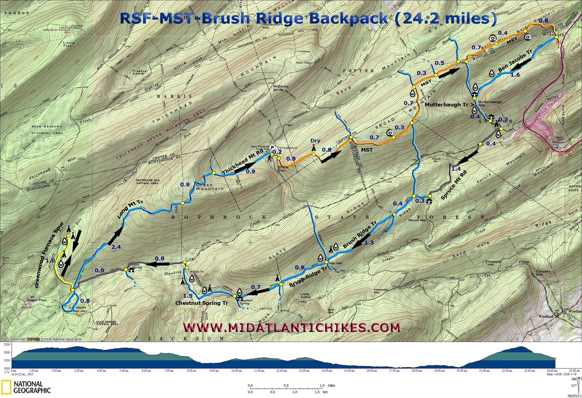
Description: The Rothrock State Forest is named for the late Dr. Joseph Rothrock, a native of Mifflin County, who is recognized as the Father of Forestry in Pennsylvania. Through his guidance the state purchased thousands of acres of barren forest to protect them from future abuse. These lands eventually became Bald Eagle and Rothrock State Forests. What exists today was made possible by men and women like him. Located just south of State College the forest has become a retreat for students and teachers as well as local residents and distant adventurers like us. It supports a well maintained trail system as well as a portion of the Mid-State Trail (MST) which runs form Greenridge SF, MD in the south to the New York Border above the PA Grand Canyon. Described here is a moderate 24.2 mile backpack featuring ridge top vistas, pretty streams and forest, the Alan Seeger Natural Area with its 500 year old Hemlocks and the Thickhead Wild Area. Of the total distance 3.6 miles is on paved and gravel roads. Of all of the camping areas shown on the map only two are established sites. Although you may be lacking a fire ring (Please don’t build a new one.) you will be insured a greater degree of solitude than found in more established areas. Google Maps Custom Driving Directions The hike starts at the Penn-Roosevelt SP picnic area. The MST and Greenwood Spur are part of the Great Eastern Trail (GET). |
|
________________________________________ |
|
Printable/Downloadable Map (11X17 best) Zipped National Geographic TOPO! GPS and Universal GPX Files |
Trail Notes: Only the Mid State Trail (MST –orange) and the Greenwood Spur (yellow) are blazed. Most trail junctions are signed. From the parking area follow the trail behind the lake dam to a gravel road. Cross it, jogging to the right, to pick up the Mid State Trail (MST). A blue blazed trail will come in on the left as you begin a steep climb (400 feet in 0.4 miles). The climb continues at a more gradual rate until you reach a small dry campsite 0.8 miles from the road crossing. In 0.8 more miles the Tar Pit Trail goes left as the MST goes right. This intersection is called Tri-Co. Three counties, Mifflin, Centre and Huntingdon, share boundaries here. Continue to follow the MST. Pass a window sized vista of Slate Ridge in 0.7 miles. The Indian Trail joins the tread from the right in 0.3 miles and leaves on the left in 0.7 miles just after passing a spring. Pass the junction with the Hessick Trail on the left in 0.5 miles. In 0.5 miles the Mutterbaugh Trail comes in from the left but soon continues straight ahead as the MST turns left. This trail can serve as a shortcut, shaving about 3.5 miles off of the trip but it is steep, rocky and, at times, hard to follow. Continuing on the MST, pass two north-west facing vistas in 0.7 miles. In 0.4 miles reach the last vista of the hike, a more east/south-easterly view. Here the MST begins a steep, rocky descent. In 0.8 miles from the last vista turn right onto the signed Ben Jacobs Trail, a double track access road to a hunting cabin. Cross a stream in 1.6 miles and pass a white hunters cabin. |
|
Turn left at the outhouse to pick up the continuation of the Mutterbaugh Trail. Although very rocky it is also very scenic with the stream flowing haphazardly over moss covered rocks with a canopy of Rhododendron and Hemlocks. As you squeeze through the gap notice the steep talus slopes on either side. Arrive at a green hunter’s cabin in 0.4 miles. From here follow the driveway out to paved Stone Creek Road. (There are potential camping areas on either side of the drive but I think the left side is dryer. Make sure you are out of site of the cabin if you camp here.) Turn right onto the road but in 0.4 miles turn left onto gravel Spruce Mountain Road. The road climbs steadily for 1.3 miles. There will be a parking area at the top with some gated woods roads. Continue downhill a short distance to a white cottage. There is a Brush Ridge Trail signpost next to the drive. Turn right and follow the trail into the woods. This trail is a nice hike through mostly mature woods with a few small openings along the way. In 0.3 miles the Indian Trail comes in from the right but leaves to the left in another 0.4 miles. There is also mention of a New Otter Gap Trail on the sign but we found no evidence of it. Continue straight on the Brush Ridge Trail and descend into Otter Gap. Just before reaching the gap the trail splits at a cairn. (There is a stream close by and a chance for a potential campsite but the ground is pretty rocky. A better bet might be in the gap itself where the joining streams have formed small benches.) Follow the trail to the left. At the absolute low point of the gap the Otter Gap Trail (hard to see) goes left while the Penn-Roosevelt trail goes right. Continue straight, climbing out of the gap. Reach a pretty vernal pond in 0.9 miles and the junction with the Chestnut Spring Spur on the left (No sign but obvious). This area, being at a high point, is another place won’t might be able to set up a tent. From here the trail descends gradually for 0.7 miles to a hunter’s cabin. Turn right on the driveway and cross Chestnut Spring Road on an angle to the left to pickup unsigned but obvious Chestnut Spring Trail. Except for crossing a gas pipeline twice the next 1.5 miles is some of the prettiest hiking of the trip with dense Rhododendron thickets and tall Hemlock trees as the trail maintains close contact with a tributary of Standing Stone Creek. If I had to make camp soon it would be between the beginning of the trail and the first pipeline crossing. The trail ends on Chestnut Spring Road. Turn left and then left again onto Alan Seeger/Stone Creek Road. After 0.9 miles of road walking the creek comes close to the road. Behind one of three cabins is the Ross Trail. It, the Preserve Trail and Greenwood Spur Trail can be used to access the Alan Seeger Natural Area from the south. We were running out of steam and time and decided not to investigate. In another 0.9 miles of road walking pass the Long Mountain trail on the right (part of the return leg) and soon arrive at the crossing of the Greenwood Spur. I highly recommend turning left, stashing your packs and doing the short loop through the Alan Seeger Natural Area. It is truly magnificent with its 500 year old Hemlocks, giant Rhododendron and pretty streams. Although the final leg of the hike is the Long Mountain trail there are no suitable places to camp or reliable water sources. The best place to call it a night is along Detweiler Run in the Thickhead Wild Area. Follow the Greenwood Spur as it crosses the stream several times. Potential camping is just after passing a hunter’s cabin on the left and crossing the stream on a bridge at about 0.5 miles from the road. Another good spot is in another 0.5 miles just after passing an abandoned streamside cabin. The site will be to the right of the trail on a slight rise. The ultimate established campsite w/fire ring is another 0.2 miles upstream. Assuming you camped in the Thickhead Wild Area return to Alan Seeger Road and the Long Mountain Trail. It is a double track woods road that climbs 1200 feet at an almost constant pitch over 2.3 miles. Most of the time you are hiking in the shade of mature hardwoods. As you cross a gas line swath the trail becomes single track and flattens considerably before making a rapid descent to grassy Thickhead Mountain Road in 0.9 miles. Turn right and enjoy a leisurely 0.9 mile stroll back to the Penn-Roosevelt Picnic Area and your awaiting vehicle.
________________________________________
________________________________________ Outing Critiques
Name: Kyle Hike: MST-Brush Ridge Backpack Date(s): 03/14-16/14 Rating: 3.5
Critique: The hiking started out well. The MST is fairly narrow and did not seem well traveled. We decided to take the shortcut and head down the Mutterbaugh trail. This was one of my favorite trails. The stream was great and the isolation was great. The trip took a turn for the worse when we reached the intersection of the Otter Gap trail and Penn Roosevelt Trail. Directions were "Follow the trail to the left. At the absolute low point of the gap the Otter Gap Trail (hard to see) goes left while the Penn-Roosevelt trail goes right. Continue straight, climbing out of the gap. Reach a pretty vernal pond in 0.9 miles and the junction with the Chestnut Spring Spur on the left (No sign but obvious). This area, being at a high point, is another place won’t might be able to set up a tent". Well we went left and then realized our mistake and doubled back. Then we tried to go "straight" and there was nothing of a trail to follow. We bushwhacked for a while and eventually doubled back to Penn Roosevelt trail to make camp for the night. In the morning we decided to just take the Penn Roosevelt trail up and over the ridge. Well the trail kind of stopped and looked to go right. After a while we decided that couldn't be right and just bee lined it up the ridge and over the other side. The trails are not marked well or very much at all. The directions were good until the Otter Creek/Penn Roosevelt trail. Enjoyed the hike nonetheless, but just wish it all worked out better. ________________________________________ |
|
|