|
Bear Meadows Loop 08/21/10 |
|
Description: The Rothrock State Forest is named for the late Dr. Joseph Rothrock, a native of Mifflin County, who is recognized as the Father of Forestry in Pennsylvania. Through his guidance the state purchased thousands of acres of barren forest to protect them from future abuse. These lands eventually became Bald Eagle and Rothrock State Forests. What exists today was made possible by men and women like him. Located just south of State College the forest has become a retreat for students and teachers as well as local residents and distant adventurers like us. It supports a well maintained trail system as well as a portion of the Mid-State Trail (MST) which runs from Greenridge SF, MD in the south to the New York Border above the PA Grand Canyon. Described here is a short and easy 3.0 mile �Nature Quick Fix�. The trails are flat, well marked and maintained. If you just have a couple of hours to spare this is the place to go. Want something longer and harder? Add this to one of the other hikes being added to this site soon. |
|
Google Maps Custom Driving Directions The hike starts at the kiosk at the Bear Meadows parking area on the road of the same name. ________________________________________ |
|
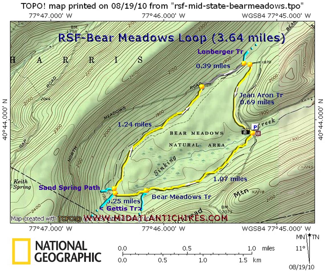
Trail Notes: From the kiosk take the yellow blazed Bear meadows Trail to the left. Enjoy the views of the meadows as you will soon be surrounded by dense Rhododendron thickets and Hemlock trees. After a while more hardwoods will become mixed in with the forest. At 1.07 miles pass a junction with the Gettis Trail on the left. The two trails run concurrently until the Gettis trail leaves again on the left in another 0.25 miles. Cross a stream and enter a grassy area with a fire ring. (Note: Camping is not allowed in any Natural Area in PA.) The Sand Spring Path goes off to the left. Bear right to continue. In another 1.24 miles the trail ends on North (Bear) Meadows Road. Turn right. In 0.39 miles pass the Lonberger trailhead on the left and shortly thereafter turn right onto the Jean Aron Path. Follow it for 0.69 miles back to the parking area.
Zipped National Geographic TOPO! GPS and Universal GPX Files |
|
________________________________________
________________________________________ |
|
|