| Stone Tower Loop |
|
|
Description:
For more information about Saint Anthony�s Wilderness and SGL
211 see the Rausch Gap Loop. Although this hike is shorter than
the other SGL 11 hikes described on this site it is much more
�rustic�. Although their ancestors were also old haul roads and
tram grades, these trails have a much wilder , rugged feel to
them. Most have more vegetative encroachment than experienced
elsewhere and are considerably rockier in places. Add to this
two very significant, nearly vertical rock scrambles (both up
and down) and you have one very challenging hike. From a
historical viewpoint you�ll visit the name sake of the hike, the
Stone Tower, which is actually a chimney or air shaft used
during coal mining times, The ruins of the village of Yellow
Springs and the ever popular General, an abandoned �steam�
shovel (actually powered by an internal combustion engine but
the thought of steam power is a lot more romantic) trapped by
trees that probably weren�t even seeds when its fate was dealt
to it. A keen ear and eye will help you locate an orange spring
created by acid leaching of a hidden coal mine and perhaps one
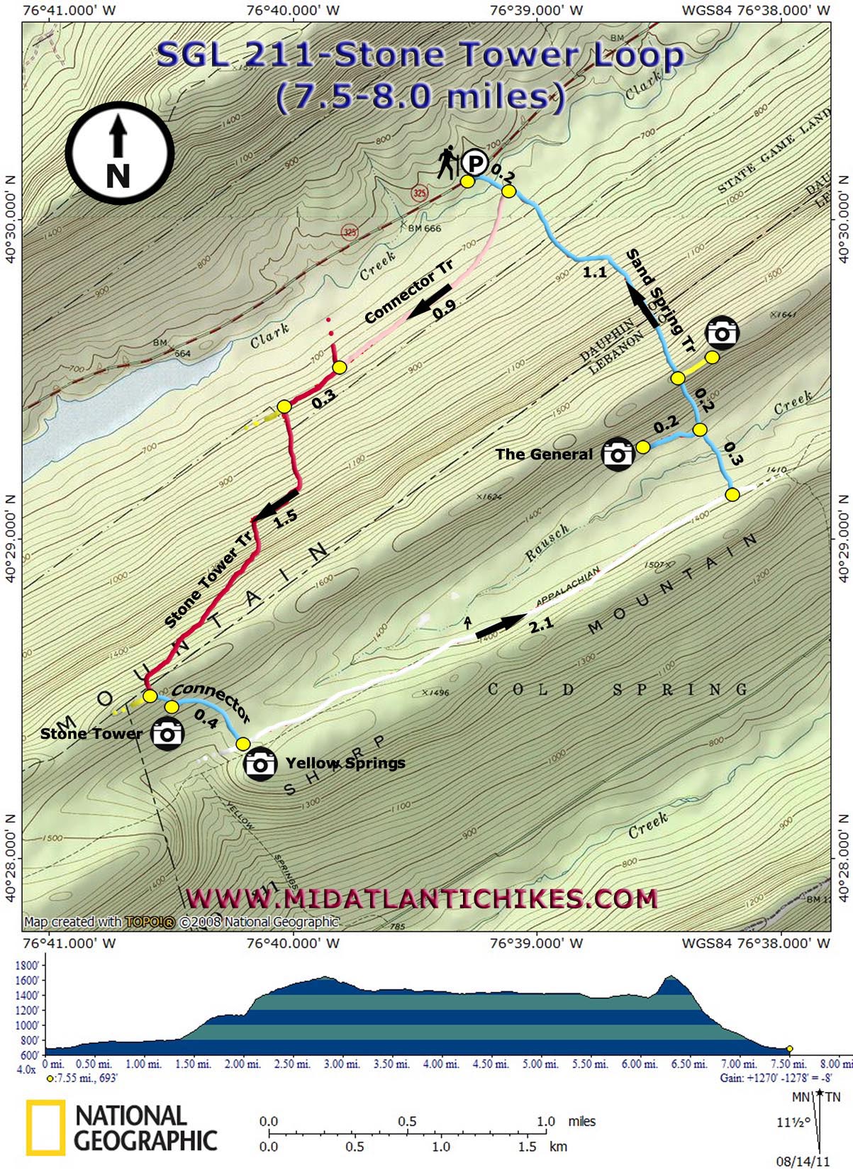
of the few vistas in the entire venue. The hike starts at a small pull over marked with double blue blazes on a tree on Rt 325. It will be hard to spot. |
|
________________________________________ |
Zipped National Geographic TOPO! GPS and Universal GPX Files |
Trail Notes: From the pull over follow a trail to Clark Creek. During periods of normal or low water flow it is a relatively easy rock hope. At 0.2 miles from the road the blue blazed Sand Spring trail continues straight up the mountain. Bear right instead onto a pink blazed connector trail. Enjoy a pleasant hike through dense Hemlocks and moss covered rocks for 0.9 miles where the red blazed Stone Tower comes in from the right. Continue straight on this trail. In 0.3 miles arrive at a yellow blaze straight ahead. I�ve been informed by the folks that work on the trail system that this is a bogus trail. Turn left and follow the red blazes. The trail soon disintegrates into a steep talus slope. Continue to follow the red blazes , some on rocks, straight up for about 0.3 miles. Here the trail bends to the right joining an old tram grade. Small loose rocks continue for a while but the pitch of the grade lessens dramatically. After another steep but short climb reach yet another grade, this one nearly rock free. In 1.5 miles from turning left out of the valley arrive at the junction of the yellow blazed Yellow Springs Trail on the right and a blue blazed connector on the left. Follow the blue connector and in 0.1 miles arrive at the Stone Tower. After examining this industrial artifact continue on the blue trail for another 0.4 miles. This is the intersection with the AT and the site of what was once the village of Yellow Springs. Turn left and follow the well manicured AT for 2.1 miles and turn left onto the blue blazed Sand Spring Trail. Cross Raucsh Creek and in 0.3 miles from leaving the AT bear left onto an unsigned but otherwise obvious trail. In 0.2 miles reach the General and all of its rusting glory. Retrace your steps to the Sand Spring Trail, passing a spring contaminated by acid run off to the right, and turn left. The trail immediately begins a steep rocky climb. As you reach the summit, look for a yellow blazed trail on the rightthat leads to a nice vista. From here the trail begins a rapid descent through a rock field, similar in difficulty to the initial climb but perhaps harder on the knees. About halfway down the trail joins what seems to be an old skid road as it travels through a dense Hemlock forest. In 1.1 miles from the summit the trail rejoins the earlier pink connector. Cross Clark Creek once again and retrace your initial footsteps back to your vehicle. |
|
________________________________________
________________________________________
Name: lwtrekpa Hike: Stone Tower Date: 11/15/14 Rating: 4.3
Critique:
Directions are pretty spot on. As far as trailhead goes, your are
more apt to see blue spots on tree off 325 heading east away from
Deharts reservoir then you will be coming west. A good guesstimate
would be that the trailhead is 1.5 miles away from inlet side of
reservoir. Parking is best on opposing side of trailhead about 50
yards past (going east) the trailhead.
________________________________________ Date: 4/28/13 Rating: 4
Critique: Hike is fun and "The General" is a cool sight. If the water level is high there's a fallen tree with wire strung across for hand holding across Clark Creek. Rocky and occasionally steep in parts so bring tough boots. ________________________________________
Name:
kayakdog Hike: Stone Tower ________________________________________
Name:
j. a. b.
Hike: Stone Tower Loop
________________________________________
Name:
Joe
Hike: Stone Tower Loop ________________________________________ |
|
|