|
Tracy Ridge Base Camp Backpack w/Day Hike 04/17/2010 |
|
|
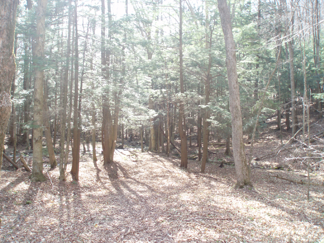
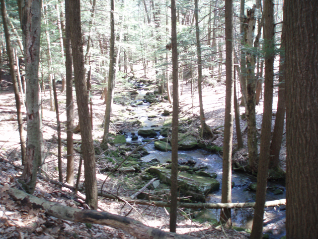
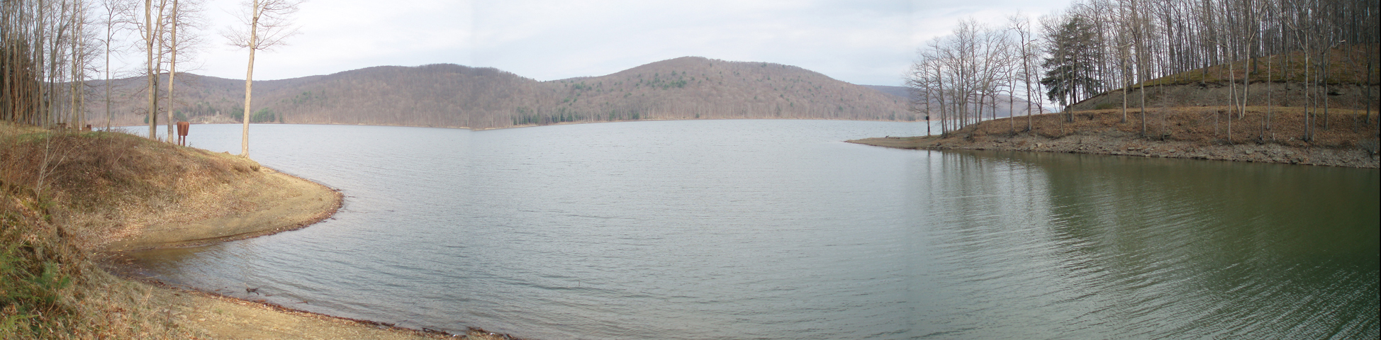
Description: Tracy Ridge Recreation Area is located on the eastern shore of Allegheny Reservoir mere minutes from the southern border of New York. It boasts of a 119 site improved campground, two hike in or boat in primitive campgrounds and a 34 mile underutilized trail system. To add to the hiking experience approximately 8 miles of the 96.3 mile North Country Scenic Trail (NCST) goes through it, connecting with several of the system�s trails thereby creating several loop possibilities. Its highlights include views of the reservoir, second growth forest, moss covered boulders, scenic streams and beautiful Hemlock glens. You should find loads of solitude here. The NCST is blazed blue, well maintained and easy to follow for the most part. The Tracy Ridge Trail System (TRTS) is blazed with white and gray diamonds. (The latter are very hard to see from a distance. Extreme diligence is required at times to stay on trail.) In several places the only hint that you are on a trail are these blazes. Most trail junctions are numbered. At some trail junctions signage has been removed by vandals. Finally, the Forest Service has no trail crews to maintain the TRTS. This further adds to the �wilderness feel� of an outing here as you will have to navigate through several blowdowns. |
|
Described here is a 6.34 backpack to a base camp on Johnnycake Run followed by a 12 mile day hike. On the final day you�ll retrace the steps of the first day. Google Maps Custom Driving Directions ________________________________________ |
Zipped National Geographic TOPO! GPS and Universal GPX Files |
Trail Notes: This trek starts at the North Country Scenic Trail parking lot on Rt 346. From the parking lot, turn left (east) onto Rt 346 and cross the bridge over Willow Run. Climb over the guard rail and pick up the blue blazes. Climb gradually passing or walking through some great Hemlock glens. As you near the top you�ll gradually turn south as you hike between the main ridge on the left and a lower knob to the right. In 3.85 miles descend to Tracys Run, more Hemlock trees and some good camping.(A much shorter version of this trip can be done by camping here and forming about a 7 mile loop by combining the NCST, the trail formerly called the Johnnycake trail and the original Tracy Ridge Trail.) Continue around the cove past another campsite. Here the NCST could use a few more blazes as it is difficult to follow as it climbs gradually through some Hemlocks arriving at junction #11. Bear right to follow the NCST. As you turn to follow the main lake from a higher elevation you�ll walk along some of the best constructed side-hill trail I�ve ever hiked on. In 2.37 miles from Tracys Run descend to junction #10, Johnnycake Run and a large campsite under more Hemlocks. This is your home for the next couple of days.
Day Hike: Continue south on the NCST. As you turn left to parallel the lake join an old haul road (0.50 miles from camp). There are a lot of blowdowns in it but the berm on the right is kept open for hikers. In another 0.4 miles arrive at junction #9. A sharp right turn will take you down to the Handsome Lake Campground and a good view of the reservoir. Continuing on, follow the haul road for another 0.67 miles to junction #8. As of this writing this junction is missing a sign although the post is still there. The blue blazes go to the left on a footpath. Continue straight on the haul road following white diamond blazes. In 0.29 miles the trail veers left off of the haul road onto a footpath. Follow the blazes and in 0.81 miles arrive at Hopewell Campground. This is a smaller version of the Handsome Lake Campground but has a better view of the lake. The trail continues by the outhouse. Soon the blazes turn from white to gray and can be hard to pick out from a distance. Although the blazes continue the trail becomes harder to follow at times. |
|
In 0.83 miles from the campground pass through a grove of large white pines. This would make an excellent campsite for another trip. Shortly after this you�ll have to negotiate some blowdowns. In 1.17 miles from this campsite cross Pollys Run. This is a good lunch spot and potential camping area. Almost immediately the trail leaves the stream and climbs steeply via a couple of switchbacks to another old haul road (0.24 miles from lunch). Turn left onto it. In 0.12 miles the trail will veer off of the road to the right to avoid some wet areas. Personally, I recommend staying on the road and putting up with some mud. In 0.30 miles the detour rejoins the road. There is yet another brief detour but it is hardly worth mentioning here. Stay on the road. In 0.78 miles the road becomes a footpath and in another 0.34 miles arrives at junction #6. Here you will see the familiar blue blazes of the NCST to your left and right. The sign was missing here but we scribed the number 6 into the post to help others with the identification of the junction. Continue straight, following the gray blazes. In 1.19 miles pass junction #5 with a trail to the right. From here it is 2.33 miles to junction #4. From junction #4 it is only about 0.10 miles to junction #3. Turn left here and descend towards camp. Pass junction #17 on the right in 0.85 miles. Over the next 1.39 miles you�ll be walking through what I think is the prettiest Hemlock glen in the area. Arrive back at camp and relax for the rest of the day.
On your final day all one needs to do is break camp and retrace his/her initial steps back to their vehicle.
________________________________________
________________________________________ |
|
|