| Trough Creek State Park Circuit |
|
|
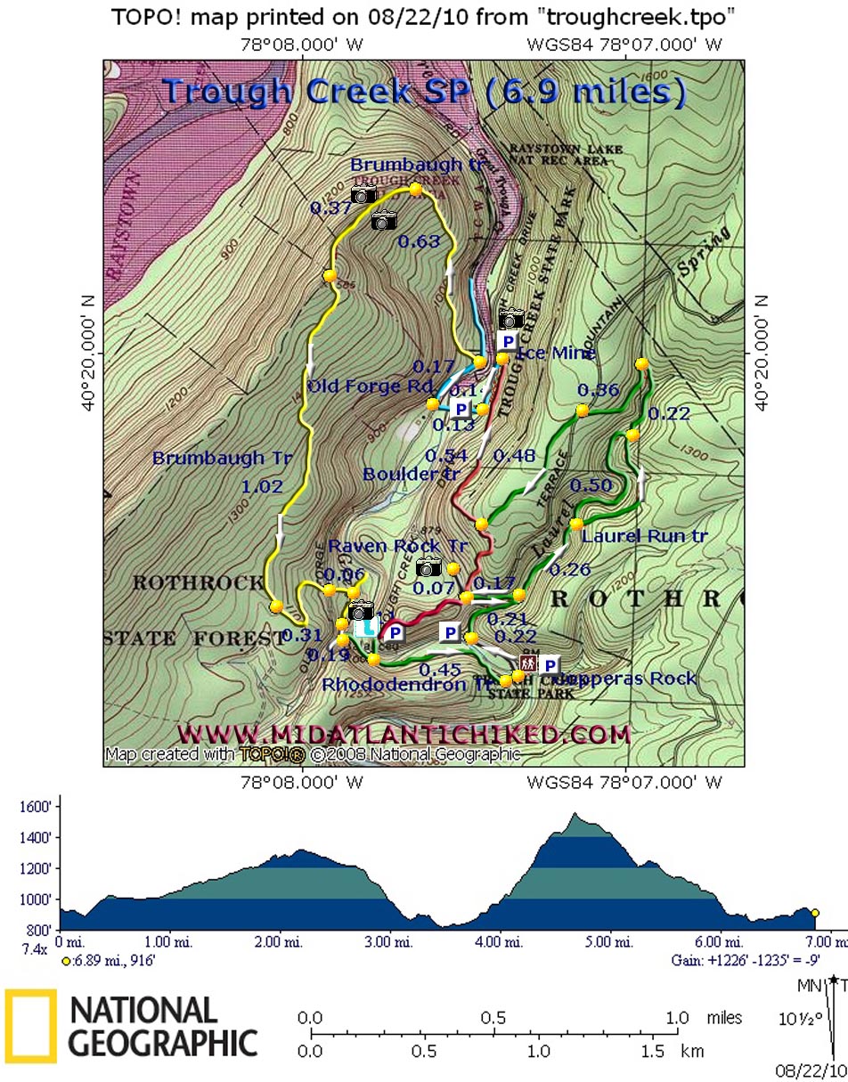
Description: At a diminutive 554 Acre, Trough Creek State Park is one of the diamonds in PA�s crown jewels of state parks. The creek cuts its way through a steep rocky gorge on its way to Raystown Lake passing natural wonders like Copperas Rocks, the Balanced Rock, Ravens Rock and the old Ice Mine as well as the man-made suspension bridge across the creek. Throngs of visitors visit them every weekend during good weather. Fortunately for the avid hiker most foot traffic comes to a sudden halt a very short distance beyond them. The trail system, some of which passes through Rothrock State Forest is pretty rustic even though most of it is well maintained. Described here is a moderate 6.9 mile hike with about 1200 feet of elevation gain. Google Maps Custom Driving Directions The hike starts at the Copperas Rock parking area on Trough Creek Drive across from the rock itself. The hike can be joined at almost any trailhead parking lot along the Drive. |
|
________________________________________ |
Zipped National Geographic TOPO! GPS and Universal GPX Files |
Trail Notes: After visiting Coperras Rock (The yellow stains are from Iron Sulfate leaching from a coal seam somewhere above it. Ancient Latin for this chemical compound is �Copperas�.) walk down the drive, crossing Trough Creek on the pedestrian side of the bridge. For safety�s sake descend to the picnic area on the left and walk through it to its parking lot. Cross the road and join the green blazed Laurel Run Trail. During periods of high water this little stream is quite pretty but even without good water flow the rocky gorge full of Rhododendrons and Hemlocks has a very boreal feel to it. The old grade the trail follows is severely eroded in spots and all of the eight bridges mentioned on the park map have either rotted away or otherwise been destroyed. Still, stream crossings should never really be an issue. At 0.21 miles from joining the trail a spur takes off sharply to the left for 0.17 miles to gravel Terrace Mountain Road. Turn here and then turn left onto the road for 0.07 miles to visit the well preserved remains of a furnace used in the iron refining industry centuries ago. Retrace your steps to the main trail and proceed upstream. In another 0.26 miles a high water trail takes off to the right and rejoins the main trail in another 0.50 miles. I explored part of this by-pass and it is a well constructed trail. In 0.21 miles after the high water trail rejoins the main trail make a final crossing of the main branch of the stream. The abutments of the old bridge still remain. Cross the very small left fork and watch for a small �trail� sign on a tree to the left. Turn here and climb quite gradually for 0.36 miles to Terrace Mountain Road. Cross it on an angle to the left and join a easy to walk on woods road. In another 0.48 miles pass a shortcut trail on the right and arrive at the junction of the red blazed Boulder Trail. Turn right following the sign to the Ice Mine. Descend gradually for 0.48 miles through Mountain Laurel and Hemlock to Trough Creek Drive and the Ice Mine.
After visiting the mine turn left on the drive and walk up it for 0.14 miles and turn right into Picnic Area #5. (At this point you are also hiking on the Terrace Mountain trail.) Cross the bridge over the creek and turn right onto Old Forge Road. |
|
Watch carefully for the Brumbaugh Trail sign as it is high up on the hill to your left and very hard to spot. (If you see the old park dam down on your right you went too far.) In 0.17 miles from joining Old Forge Road turn left onto the Brumbaugh Trail. (The park map and sign posts indicate that this trail is blazed orange. We saw only two such blazes, all on the eastern side of the trail. The remainder of the trail has recently been re-blazed with fresh yellow paint.) The trail climbs gradually but steadily up the left side of the gap in Terrace Mountain that has been carved out by the creek. This portion of the forest has been devastated by a Gypsy Moth infestation years ago leaving the canopy open, allowing dense vegetation to seriously encroach on the trail. There are few blazes (mainly because there are no suitable trees to put them on) but, as of this writing, the trail still is not that hard to follow. As you approach the top the trail suddenly seems to peter out. Look behind a small tree for it as the trail suddenly jogs to the right around it for a few steps before beginning a nice but short ridge walk with the sides of Terrace Mountain falling away quickly on either side of you. Here you will get window size views of the Lake to your right and views across the creek valley to your left. The trail will turn to the left to climb over the final summit of the hike at around 1600 feet (0.37 miles from where the trail snuck behind the tree.). It is marked with a large carin. The 1.02 mile descent is on well blazed woods roads surrounded by a healthy hardwood forest and fern understory. The road you are on will veer off to the right into a gated open meadow (an old log landing). Stay straight on yet another road that passes under a canopy of Striped Maples. The trail will join yet another road but only for a short distance before turning right onto a footpath and arriving at Old Forge Road (0.31 miles from the log landing).
Cross the road onto a hunter�s cottage drive but bear off to the right onto an un-blazed but obvious footpath. Turn right onto the Raven Rock Trail and in 0.10 miles arrive at Balanced Rock. For the next 0.2 miles expect to see a lot of foot traffic. After the Balanced Rock descend a short distance on the white blazed Abbots Run Trail but soon turn left onto a set of rock steps and further descend to a wooded bridge below Rainbow Falls (just a trickle when we were there in August). From there follow the green blazed Balance Rock Trail for 0.19 miles to the suspension bridge. Do not cross it but continue straight. The creek-side trail is still blazed green but is now referred to as the Rhododendron Trail (for obvious reasons). Follow the trail for 0.45 miles to its junction with the Copperas Rock Trail. (Note: There will be one VERY steep thirty foot climb requiring a bit of upper body strength as you scurry to the top of a cliff overlooking the creek.) Turn left at this junction and soon return to the parking lot.
________________________________________
________________________________________
Name: Ed. S
Hike: Tough Creek SP ________________________________________ |
|
|