
| Volkswagen Circuit |
|
Description: For more
information on the Frederick Municipal Forest see the
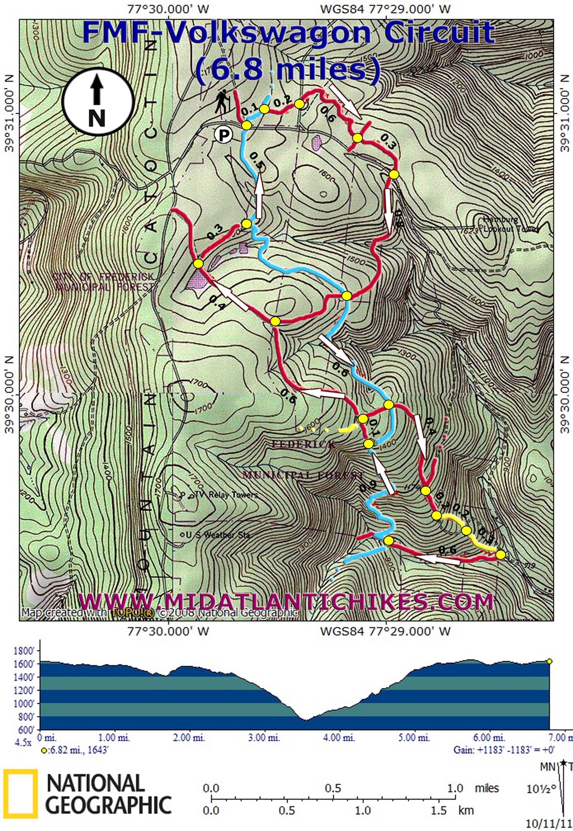
Clifford Hollow Hike. This is the fourth in a seemingly never ending series of hikes in this wonderful "get away from it all" place. If you live in Baltimore or D.C. you can be in the middle of the woods in less than 1.5 hours. This 6.8 mile circuit descends and ascends about 1200 feet and does both mostly all at one time so it is easy to get the hard work behind you all at one time. The trails are well maintained but only one is blazed. If attempting this hike bring this map, trail notes and compass (GPS is helpful). |
|
________________________________________ |
|
Zipped National Geographic. TOPO! GPS and Universal GPX Files |
Trail Notes: Cross the road. As you look into the woods take the trail to the right. Although the first blaze you might see is white this is the Catoctin Trail (Usually blazed blue). In a mere 0.2 miles turn right onto a serpentine bike path known by the bikers as the Knuckle Buster. Cross Gravel Fishing Creek Road in 0.2 miles. Arrive at a four-way road junction in 0.6 miles. Continue straight but soon turn left onto the continuation of the bike path. Cross Hamburg Road in 0.3 miles from the last junction. Jog slightly to the right to pick up the Volkswagen Trail. It starts as a foot path but soon reverts to an old jeep road. You�ll pass the obvious namesake of the trail and reach the intersection with the Catoctin Trail in 0.8 miles from the Hamburg Road crossing. Turn left, following the blue blazes for 0.6 miles, reaching a sunken jeep road (probably a skid road during the logging days). If you want to shorten the hike you can turn right. To complete the entire circuit turn left on the road. At times there will be a bike trail on the left side of the road. At 0.4 miles from joining the road another road/trail comes in from the left. Continue to follow the left bank of the road for another 0.2 miles. Here bear left onto a bike path blazed with yellow spray paint. In another 0.2 miles the yellow trail crosses the old road at a dog leg. Continue to follow the trail. It loses its identity after a jump but the 0.3 mile descent down to another jeep road is open although steep. Turn right onto the road and soon reach the un-named stream that flows through Clifford Hollow. Do not walk out to the gravel road that is within sight. Cross the stream and turn right (upstream), cross a fork in the stream and join another jeep road. Follow this smooth road for 0.6 miles, crossing the stream one more time, and arrive at another junction with the Catoctin Trail. Turn right onto it and switchback up the hill for 0.9 miles. This is the only hard part of the trek so take your time. Shortly after passing a small sign for the Manor Area turn left onto an obvious bike path. Don�t worry if you miss it. If you do you will soon find yourself on the sunken jeep road you used earlier. The bike path soon cuts through an open grassy area and passes another bike path on the left. Stay straight and in 0.1 miles turn left onto the previously mentioned jeep road. (It�s not sunken here.) After a short, slight climb the road flattens out. Another trail joins from the right in 0.6 miles. (This does not include an old driveway with a demolished blue gate.) |
|
The road passes through young woods and Mountain Laurel tunnels. In 0.4 miles from the last trail junction, cross the breast of an earthen dam. The outtake pipe for the pond has been spiked in several places. The road continues out to Gambrill Park Road. After crossing the dam bear right onto another bike path. In 0.3 miles join the Catoctin Trail, which comes in from the right, once again. In another 0.5 miles arrive back at your starting point on Hamburg Road.
________________________________________
________________________________________ Outing Critiques
Name: MSF Hike: Volkswagen Circuit Date: 07/20/14 Rating: 4
Critique: Overall a very enjoyable hike. The highlight has to be the cascading stream in Clifford hollow, whose trail crossing make for good lunch spots. The abundant mountain laurel suggest late May/early June would be the best time to hike. Although the weather was beautiful for late July, we only saw 3 mountain bikers the whole hike. One note, the sunken jeep road is severely washed out and a few bad blowdowns significantly impeded the path. Mountain bikers have cut a parallel path to the south and west of the road that would be advisable to follow instead (can be picked up by following single track path to left of Catoctin Trail on the south bank of the sunken road crossing). _______________________________________
Name: .com
Hike: Volkswagen Circuit _______________________________________ |
|
|


