|
Weverton to Maryland Heights |
|
|
Description:
The difficulty of this hike is hard to gauge. Of the 9 miles
traversed only 1.5 to 2.0 miles requires a significant elevation
gain. That portion may be difficult but the rest is nearly flat and
smooth. The trek is rich in history and scenery. You'll spend about
6 miles walking the towpath of the C&O Canal, passing a Lockmaster's
dwelling, a Railroad tunnel, the ruins of a building reputed to be
an old tavern, the Potomac and Shenandoah Rivers, views of Harpers
Ferry from the heights and perhaps lunch or an ice cream cone as you
visit the town itself. It is here that John Brown ignited the
Abolitionist movement that sparked the Civil War. It is also here
where Stonewall Jackson, in a prelude to the Battle of Anteitam,
capture 12,000 Union troops while sustaining minimal losses to his
command. If you have the time and energy add another 2 miles and
visit the Stone Fort and gun emplacements at the very crest of the
ridge. One note: This is not the place to go if you desire solitude. Spring, Summer and Fall especially bring out the crowds who shuttle into town for shorter excursions. Turn onto Weverton road and pull into the gravel lot on the right. |
|
_______________________________________ |
|
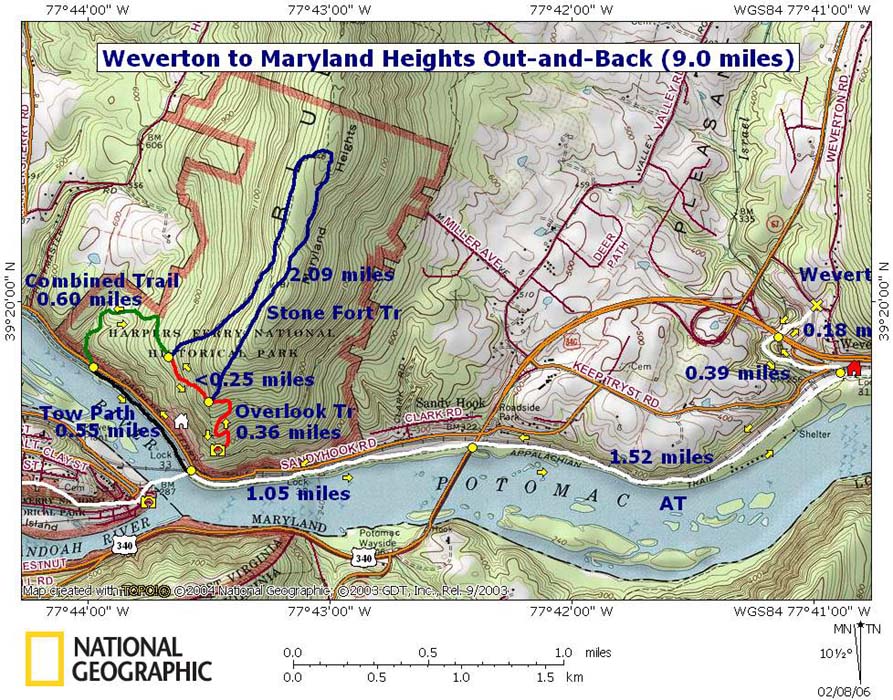
Trail Notes: From the parking lot descend on the white blazed Appalachian Trail. You'll pass under U.S. Route 340 and cross a small road and train tracks before crossing the C&O Canal at Lock 31 ( 0.39 miles from the start). You will also pass a Lockmaster's House at the canal. Turn right onto the towpath and follow it all the way to the trailhead for Maryland Heights. As you proceed up river you will pass under U.S. Route 340 again (1.52 miles from Lock 31), and under the RR bridge going to Harper's Ferry in another 1.05 miles. The AT follows the bridge into town. Stay on the towpath for another 0.55 miles. Cross a footbridge over the canal ruins and then a gravel road to arrive at the Maryland Heights trailhead. Proceed up the green blazed Combined Trail. In 0.6 miles the trail splits. Blue blazed Stone Fort Tr goes to the left and red blazed Overlook Trail goes to the right. Follow the Overlook Trail. In about another 0.25 miles pass the other terminus of the Stone Fort Trail and descend to a vista with a dramatic view of the Potomac and Shenandoah Rivers, Loudon Heights, Bolivar Heights and the town itself. To complete the trek simply retrace your steps back to the car. If you want a longer trek and/or want to see more history turn right onto the Stone Fort Trail at its first junction and follow it to its junction with the Combined Trail. This will add about 2 more miles to the hike as well as some more climbing. Also, as you pass by the RR bridge consider crossing over to Harpers Ferry to visit that historic place and partake in a beverage or ice cream. |
|
________________________________________
Name: Treebeard
Hike: Weverton to Maryland Heights
|
|
|