Appalachian Trail - Bluff Trail Loop


Description: This is a 14.0 mile strenuous circuit hike (15.1 with a side trip to a vista above Big Devils Stairs) in the Shenandoah National Park, VA. The degree of difficulty is based more on the length and less on the elevation gain (2100 feet total). The climbs are steep in only a couple of places. Westward views are had on both North and South Marshall Mountains. With a keen eye you will also find a dead southerly view pretty much looking down into the Big Devils Stair drainage. The side trip down to an overlook of Big Devils Stairs is well worth the effort on a clear day. Just remember you have to climb back up! The trails are well maintained. While the going may be slow for the first 5 miles a good pace can be maintained for the last 8-9 miles. This can be done as a day trip or an over night backpack. Camping is allowed at the Gravel Spring shelter by permit only. I've not checked them out but there are supposed to be tent sites a short walk away. The PATC recommends allowing 7.5 hours for the root trip. We did the entire trip in 6 hours and 15 minutes including lunch because of the foul weather. If the skies are clear you may want to allow extra time to adsorb the views at the overlooks.

The hike begins in a parking lot on the west side of Skyline Dr between mile marker 12 and 13.

Google Custom Directions 

________________________________________


Printable/Downloadable Map

View 3-D Map

Zipped National Geographic. TOPO! GPS and Universal GPX Files 

GPS Text File for Non-TOPO! Users


Trail Notes: Find the AT sign post in the left corner of the parking lot and proceed downhill following the yellow blazed Jenkis Gap Trail for just a few steps. Shortly come to another signpost. Yellow blazed Jenkins Gap Trail and the AT north goes right. White blazed AT south goes left. Bear left and climb. After reaching the crest of the first hill descend to and cross Skyline Drive at 1.87 miles from the start.


Begin a gradual climb up the back of
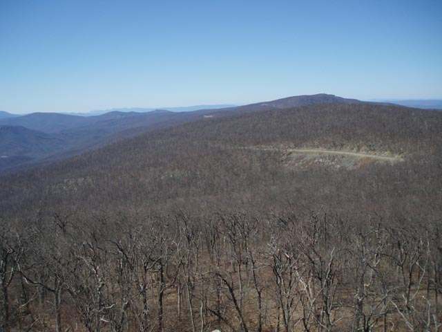
 North Marshall Mountain. At about 1.7 miles from crossing the drive reach the crest of the mountain and an overlook. Descend, steeply at first. In a few yards look for a tall rock outcrop to your left. There is a trail that takes you around its back and to its top. From there you can catch a view directly south into the Big Devils Stair drainage. Cross Skyline Drive for a second time (0.41 miles from the last vista).


At about 0.64 miles from the last SLD crossing reach the summit of South Marshall Mt and more views. Descend to Skyline Drive a third and final time at 0.82 miles from the last vista.


Walk across the Gravel Springs parking lot. A yellow blazed trail (Harris Hollow Tr?) is to the left. Take the AT on the right. At a fork the AT will go right and blue blazed Bluff Trail goes left. Follow Bluff trail down to a trail intersection. Gravel Spring Shelter is to the right. Turn left to continue on.


Immediately come to another fork. Bear right on now yellow blazed Bluff Trail. As you switchback down the hill for a bit pass a Horse Trail on the left. At the last left switchback yellow blazed Harris Hollow Trail goes straight. Make the left switchback following the sign that states "Big Devil's Stairs - 1.3 miles". The Bluff trail is now blazed yellow.


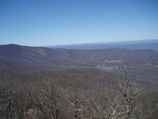
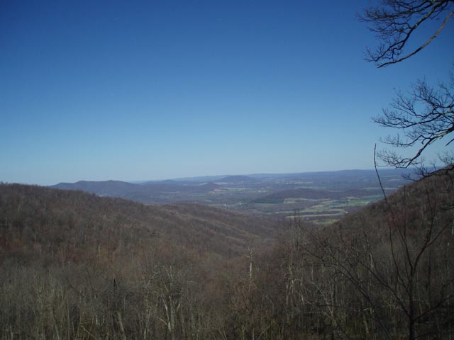
In 1.39 miles arrive at the junction with blue blazed Big Devil's Stairs Tr on the right. If you wish to visit Big Devil's Stairs turn right here and follow the blue blazed trail approximately 0.55 miles. The trail will continue further down through the ravine but is blocked by private property at the park's boundary. At 0.55 miles there is a bit of an overlook on a rocky ledge that allows you to view the ravine. From this point retrace your route back to Bluff Trail and turn right.


In 2.30 miles reach yellow blazed Mount Marshall Trail. Stay straight to continue northward on Mount Marshall Trail. Cross 3 streams and begin a gradual climb. At 3.60 miles from the last trail junction arrive at Skyline Drive. Turn right, passing Jenkins Gap Overlook, and turn left into the parking lot.


Printable/Downloadable Directions and Trail Notes

  Read about our scouting trip 

 Read about our latest trip there

Critique This Outing

________________________________________

________________________________________

Name: Jimi                                                                                                                   Hike: Mt. Marshall Trail / AT loop
Date: 5/3/2012-5/4/2012                                                                                      Rating: 4.5

Critique: Great hike that in my opinion is not strenuous but only moderate - though this was my first hike in Shenandoah and I realize difficulty ratings are fairly relative. The trails in this loop, overall, are ~80% "flat", meaning they hug one elevation line and any ascents that are significantly steep are short and far between. The one exception is the ascent from skyline drive to South Marshall, which is really not even the steepest climb on this hike, merely the longest.

There are a lot of parking lots along this loop and therefore many different ways to break it up. The key decision to make is where you want to camp. We camped on the Bluff Trail right at the junction with the Big Devil Stairs Trail, where there is a lot of open space to camp and the stream is nearby.

However, there are really pretty backcountry campsites at the overlook on the western slope of North Marshall, about half a mile "south" on the AT form the summit. This outlook is not actually on the trail but is reached this way: when the AT reaches elevation ~3200 on the western slope of North Marshall (approx. where the 2 photo-op yellow spots are on the map on this page), the AT turns sharply to the left and climbs up some a steep hill, but if you instead continue straight, going off the AT, there is a large boulder face ~100 ft. ahead. Turning left at this boulder, there is a short scramble up to the top of it, where you can walk onto the top of the boulder and look out to the west. The boulder is a nice area for potential camping with very pretty views.

The only problem with this campsite is there is no water. However, if you filled up at Bluff Trail/Big Devil Stair junction and brought enough water with you to camp with, the views might be worth it.

Overall my main recommendation is going into the Dickey's Ridge Visitor Center (if approaching form the north) and talking to them about the best place to park and camp.

________________________________________

Name: Laurie                                                                                                               Hike: AT/Bluff Trail Loop
Date: 9/13/08                                                                                                            Rating: 3

Critique: Hiked this loop and as suggested by the Park Ranger to camp near the entrance to Big Devil Stairs where there are a couple sights already cleared for tents. Saw lots of animal droppings and only sighted 1 deer. Not much for views, might be more scenic after leaves fall. Trail was pretty rocky and it had rained Saturday night which made for slippery walking.

________________________________________

Name: Matt                                                                                                                  Hike: AT/ Bluff Trail Loop
Date: 08-02-2008                                                                                                      Rating: 4

Critique: I didn't do this entire loop. I only hiked the first section of the Appalachian Trail up to Mt Marshall and back as a short day trip. I just wanted to note that I encountered 3 bears while hiking this short section. There was lots of evidence of recent bear activity along the AT (scat, berry bushes, overturned rocks, etc). I just wanted to make a note of the recent bear activity in that area for anyone considering this hike.

Even though I didn't do the entire loop, I enjoyed this portion a lot. The views from Mt Marshall are great. I hope to go back and do the entire loop sometime later this year.

________________________________________

Name: Cory                                                                                                                 Hike: AT/Bluff Trail Loop
Date: 8/25/07                                                                                                            Rating: 4

Critique: This was my longest hike to date.  The Shenandoah National Park is quite a drive from Alexandria but well worth it.  I was surprised by the $15.00 entrance fee to the park (gets you a 7-day pass) and wasn't too happy with the fact there was no lower fee for day users.  That makes it for an expensive hike if you only go for the day like I did.  Next time I'll stay down and do a few hikes.  The hike itself was great.  While hiking I came across a female black bear with two cubs.  They were very close to the trail (about 3 miles into it near Marshall Mountain) but posed no threat to me.  She simply walked off when I froze.  I saw bear scat (both fresh and older) and signs of bears feeding on insects throughout the length of the hike.  Also saw some deer later on in the hike.  Overall was very exciting.  I wouldn't recommend this hike to anyone who is out of shape (like me) as the last 4 miles of the hike were a challenge.  I was very glad to have completed it and will actually do it again.  One note...make sure you bring plenty of water.  There is no source of clean water and I met a trio of young hikers who were out.  I ended up giving them some of mine....later wishing badly I had not (it was 100 deg and very humid when I went).  It took me 5.5 hrs to complete the base circuit.

________________________________________

Name: ElliottsKnob                                                                                                  Hike: AT-Bluff Trail Loop w/ Big Devil's Stairs
Date: Winter of 2000                                                                                               Rating: 5

Critique:
Big Devil's Staircase is a great bushwhack for hearty souls. I have not been in a while but your description has me thinking of a return!

 ________________________________________

Name: Michael Eckert                                                                                             Hike: AT-Bluff loop-Big Devils
Date: 9/29/06                                                                                                          Rating: 5

Critique: Nice long hike with several gradual ascents.  Nice views at many points on the hike.  Leaves are changing with an estimate of about 10-15 percent mixed and the rest still green.

Would highly recommend the trail to the overlook of Big Devils Staircase.  The views were great.

I wish people hiking with dogs would make an effort to pull their dogs off the trail when they have to poop.  I will be following up with a letter to SNP as this seems to becoming a problem.

Personally, I would never bring a dog on a hike in the park.  Only bad things can happen when a deer/bear crosses your path.

________________________________________

Name: Jeff Schneider                                                                                                  Hike: AT/Bluff Loop
Date: March 12 2006                                                                                                  Rating: 3

Critique: This is a nice loop if you're looking for a long hike with little elevation gain. As stated on the site, experienced hikers will barely notice any ascents. Also, unlike many hikes in Shenandoah, there aren't any spectacular overlooks.

With this considered, the half mile in/out to Big Devils Stairs is highly recommended. This gives a bit of elevation change, and a some nice big overhanging rocks, which provide a decent view.

Trails are very well maintained, wide in most areas. Not very rocky, stream crossings are barely noticeable.

I've noticed a few people say that the last half of this hike is rather boring. I disagree - I didn't see any other hikers on the Mt. Marshall trail (which is very exciting to me!) and the walks on the ridge, with the streams below were pretty scenic.

Another good thing about this hike is that it isn't too far away from the D.C. area.

Another recommendation - read the March 9th 2006 entry in the Gravel Springs Hut journal.

http://www.marylandoutdoorclub.org/events/archivedetails.asp?eventid=513

________________________________________

Name: Dale                                                                                                               Hike: Appalachian Trail-Bluff Trail Loop
Date: 6/26/2005                                                                                                     Ranking: 5

comment: A couple of corrections. Big Devil's Stair trail is 1.70 miles to the bottom (not .55) and I would like to make it very clear that anyone with bad knees/hips or who is afraid of heights should NOT start this trail. My wife and I had to "rescue" a lady who got on the overlook rock and completely froze up.

M.R. Hyker notes: The Trail Notes here describe the first 0.55 miles of Big Devil's Stairs Tr down to the first overlook. The continuation of the trail ,or about 1.25 miles, is mentioned but is not discussed. The loop as described here w/o the side trip down BDS is hard enough. Adding the short descent and climb back up makes this a very challenging trip. I commend Dale and his wife.

________________________________________

VA Hikes MD Hikes WV Hikes PA Hikes Contact Us Home