
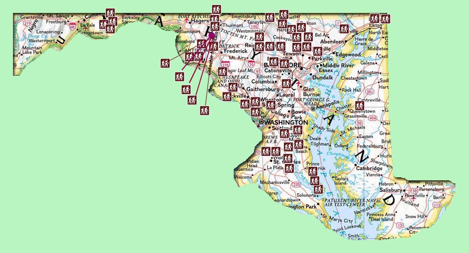
Interactive Map: Click on a Hiker Icon to go directly to a hike.
| Link |
Park/Forest |
Miles | Difficulty | GPS Data | Elevation Gain (feet) |
| Oregon Ridge | Baltimore County Park | 4.2 | E | N | N/A |
| Orange Grove Loop | Patapsco Valley State Park | 5.6 | E | Y | 1075 |
| McKeldin Area Circuit | Patapsco Valley State Park | 6.8 | E | Y | 731 |
| Hilton Area | Patapsco Valley State Park | 5.3 | M | Y | 641 |
| Perimeter Loop | Hashawha Environmental Education Center | 4.3 | E | Y | 490 |
| Hemlock Gorge | Prettyboy Reservoir Watershed | 6 | M | Y | 1549 |
| Copperhead Point Out-and-Back | Prettyboy Reservoir Watershed | 5 | E | Y | N/A |
| Gunpowder West | Gunpowder Falls SP | 7.2 | M | Y | 841 |
| Gunpowder East | Gunpowder Falls SP | 6.9 | E | Y | 683 |
| Gunpowder-Sweathhouse Branch Loop | Gunpowder Falls SP | 5.0 | E | Y | 290 |
| Gunpowder-Lost Pond Circuit | Gunpowder Falls SP | 5.1 | E | Y | 302 |
| Gunpowder - Sweet Air-East | Gunpowder Falls SP | 6.2 | E | Y | N/A |
| Gunpowder-Sweet Air-West | Gunpowder Falls SP | 6.2 | E | Y | 369 |
| Piney Point-Middle Run Circuit | Liberty Reservoir Watershed | 6.3 | E | Y | N/A |
| Morgan Run Loop | Liberty Reservoir Watershed | 8.0 | E | Y | N/A |
| Morgan Run N.E.A. | Liberty Reservoir Watershed | 5.5 - 6.4 | M | Y | 532 |
| Soldier's Delight N.E.A. | Soldier's Delight N.E.A. | 5.3 | E | Y | 417 |
| Long Pond Backpack | Green Ridge State Forest | 9 + 2 | S | Y | 841 |
| C&O Canal/Long Pond Shuttle | Green Ridge State Forest | 9.3 - 14.7 | S | Y | 2211 |
| Log Roll-Deep Run/Big Run Shuttle | Green Ridge State Forest | 12 | M | N | 1400 |
| Green Ridge North Circuit | Green Ridge State Forest | 6.8 | M | Y | 522 |
| Clifford Hollow Loop | Frederick Municipal Forest | 8.9 | M | Y | 1606 |
| Four Ponds-Rock City Loop | Frederick Municipal Forest | 11.2 | M | Y | 1434 |
| Sand Flat-Salamander Circuit | Frederick Municipal Forest | 9.4 | M | Y | 1000 |
| Volkswagen Loop | Frederick Municipal Forest | 6.8 | M | Y | 1183 |
| East Ridge Loop | Frederick Municipal Forest | 6.8 | M | Y | 790 |
| Gambrill SP Loop | Gambrill State Park | 7.9 | M | Y | 1333 |
| Greenbrier State Park | Greenbrier State Park | 7.3 | E | Y | 1041 |
| Cat Rock Circuit | Cunningham Falls SP | 7.4-11.0 | M | Y | 1532 |
| Catoctin Mt Loop | Cunningham Falls SP/Catoctin NP | 7.5 | M | Y | 1316 |
| Emmitsburg Multi-User Trail System | N/A | 7.4 | M | Y | 1040 |
| Clopper Lake Circuit | Seneca Creek State park | 7.2 | E | Y | N/A |
| Sugarloaf Mt loop | Stronghold Corporation | 7.4 | M | Y | 1386 |
| Gathland SP to Weverton Cliffs Shuttle | Appalachian Trail Section | 6.5 | E | Y | 665 |
| Weverton-Maryland Heights Out and Back | N/A | 9 | M | N | - |
| Billy Goat Trail - Section A | C&O Canal National Park | 4 | M | N | N/A |
| Billy Goat Trail Section C & B | C&O Canal National Park | 6.5 | M | Y | N/A |
| Berma Road - C&O Towpath (Carderock) | C&O Canal National Park | 4.0 - 5.0 | E | Y | N/A |
| Blockhouse Point Park-C&O Canal Loop | Blockhouse Point Park | 7.5 | E | N | 595 |
| Greenbelt Park | Greenbelt Park | 8.8 | E | N | N/A |
| Orange Loop | Cedarville Stat Forest | 6.7 | E | Y | N/A |
| Blue and White Loops | Cedarville Stat Forest | 7.3 | E | Y | N/A |
| Perimeter Trail | Rosaryville State Park | 9.4 | M | Y | 430 |
| Patuxent River Park North | Prince George's Parks | 6.4 | E | Y | N/A |
| Patuxent River Park South | Prince George's Parks | 6.3 | E | Y | N/A |
| Merkle Wildlife Sanctuary | N/A | 7.4 | E | Y | N/A |
| Jug Bay Wetlands Sanctuary | N/A | 5.3 | E | Y | N/A |
| Glendening Preserve | N/A | 3.5 | E | Y | N/A |
| American Chestnut Land Trust-North | N/A | 4.0 | E | y | N/A |
| American Chestnut Land trust-South | N/A | 4.6 | E | y | N/A |
| Calvert Cliffs State Park Circuits | Calvert Cliffs State Park | 5.2-7.4 | E | Y | N/A |
| Susquehanna SP | Susquehanna SP | 8.7 | M | Y | 903 |
| Tuckahoe State Park | Tuckahoe State Park | 5-9.2 | E-M | Y | N/A |
| Fair Hill NRMA-1 | Fair Hill NRMA | 4.4 | E | Y | 426 |
| Fair Hill NRMA-2 | Fair Hill NRMA | 7.0 | E | Y | 494 |
![]()
![]()
![]()
![]()
![]()