|
  |
Last Updated: 06/06/06
.... to a web site full of information on hiking in the Mid-Atlantic Region (PA, MD, VA and WV) ... topo maps, 3-D maps, elevation profiles, GPS data, directions, trail notes, references, photos.... everything you need to prepare for an excursion into the wilderness. Information for 110 hikes is now available. Venues such as, but not limited to, the GWNF-Great North Mt. (North-east and South-west areas), the northern and central sections of the Shenandoah National Park/VA, Massanutten Mt, VA, the Michaux State Forest in PA, the Monongahela National Forest in WV and Green Ridge State Forest in MD are represented. Bulletin Board
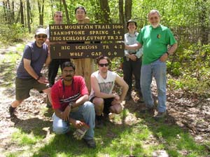
Mill Mountain/Tuscarora intersection Check out more photos of their good work at their website. ____________________________________________________________________________
____________________________________________________________________________
Dion Stemfley found a Midatlantichikes.com hat while hiking in the Shennandoah National Park. Read his story here. ____________________________________________________________________________ Have you ever wondered who maintains the trails we use? If you guessed government employees funded by our tax dollars you are mostly incorrect. While some trail maintenance is performed by the park and forest services at the state and federal level the amount of funding they receive would not permit the amount of work required to keep our trails open. The majority of this work is done by volunteer organizations. Thousands of man hours of hard labor per year is involved in this effort. Have you ever wanted to help them but did not know how to report trail conditions? There is a way and it takes no money, no labor and only minutes of time by you. If you want to help read on>>> ____________________________________________________________________________ Latest published hike(s): Apple Orchard Falls/Cornelius Creek Loop, VA, Devil's Marbleyard/Gunter Ridge Loop, VA, Knob Mt/Jeremy's Run. VA, Orange Grove Loop, MD |
|
___________________________________________________ M. R. Hyker's Latest Adventure(s) |
|
|
05-13-06: Knob Mt/Jeremy’s Run Loop - This was a scheduled Sierra Club outing. I was joined by Hardcore, Sixteen Penny, Water Bug, Indiana Moser, Ping, Eying and her daughter, Fafa (spl?). At the trailhead we added Irene who had missed the step off with her hiking group but was still determined to complete the loop. For the last 2 years we have hiked the Neighbor Mt/Jeremy’s Run Loop, which is a longer and more strenuous sister of this hike. This time we did the easier loop. Initially I thought it might end of being more challenging as the climb to the ridge was pretty difficult. Once at the top we took a short break and “watered up”. The rest of the ridge walk was a virtual romp with only minor climbs. There was Star Chickweed everywhere with clumps of Wild Geranium, Wild Oats, Columbine, Cow Vetch, Canada Violets and other flowers all along the trail. |
________________________________________________________________________________ |
|
|
The next day Tony from Hikingupward.com joined me for a 14 mile jaunt through the James River Face. Our base route was the Devil's Marbleyard/Gunter Ridge Loop described here. We scouted an additional 3 miles of the AT so I could check out a camping area and water source for a possible backpacking trip in '07. The air was slightly crisp (in the 70s w/low humidity). This made for exceptional viewing at the vistas. The Devil's Marbleyard was something to behold with rocks ranging in size from that of a basketball to ones larger than a Volkswagon Beetle. The added mileage along the AT proved to be a big plus with outstanding views in nearly every direction from "The Helicopter Landing Pad". The views along the Gunter Ridge would also have been equally exceptional except that the views were the result of a massive fire in 2002 that burned 1500 - 2000 acres of forest. Nearly every tree in the area was destroyed. The skeletons of many remain as grim reminders. Monday was a " hike just for Mike" day. I left a copy of my route with Janet in case of an emergency and headed off to hike the Apple Orchard Falls/Cornelius Creek Loop alone. I knew the first half of the hike involved about a 2000 foot gain in elevation so proceeded purposely at a slow pace. I was alone on the trail and took my time as I investigated each little grotto-esque water work. The falls was pretty impressive. The bridge and viewing platform even more so. After the falls the solitude was interrupted as I began meeting groups of hikers descending from the Parkway to view the falls. Once I turned off onto the AT I was again alone and had the feeling of having the woods all to myself. |
|
The descent along Cornelius Creek seemed even more serene, more tranquil. It was here on a gradual downward railroad grade that I thought I would pickup the pace and finish with my typical average speed. Instead I found myself dawdling even more. There was no rush to finish. I eventually made it back to the car and then back to camp where Janet and I relaxed over some simple camping fare. The next day we broke camp and returned once again to reality. It looks like we've found another venue to explore. I'm sure we'll be back. ________________________________________________________________________________ Latest Outing Critiques
________________________________________________________________________________
________________________________________________________________________________
Name:
WVwanderer
Hike:
Cranberry Wilderness Backpack
Name:
Tony
Hike:
Devil's Marbleyard/Gunter Ridge Loop ________________________________________________________________________________
Melissa
Hike:
Otter Creek Backpack
________________________________________________________________________________
Name:
Ryan Alford
Hike:
Chuck Keiper Tr - East
________________________________________________________________________________
Name:
Craig
Hike:
AT-Sunset Rocks Circuit
________________________________________________________________________________ ________________________________________________________________________________
|


 For
those of you who have hiked the Great North Mountain in the past or plan
to do so in the future take note that the all volunteer Stonewall Brigade Trail
Crew of the PATC has installed some new signs at the following trail
junctions:
For
those of you who have hiked the Great North Mountain in the past or plan
to do so in the future take note that the all volunteer Stonewall Brigade Trail
Crew of the PATC has installed some new signs at the following trail
junctions: We have recently received 24 of these stunning brushed
cotton caps. We will be placing them along our
route as we hike (one per hike). They won't be hidden so should be
rather easy to find. We will also provide waypoints for you folks that
are into geocaching. As we "plant" our presents to you we will add the
hat photo to the appropriate hike link and a
We have recently received 24 of these stunning brushed
cotton caps. We will be placing them along our
route as we hike (one per hike). They won't be hidden so should be
rather easy to find. We will also provide waypoints for you folks that
are into geocaching. As we "plant" our presents to you we will add the
hat photo to the appropriate hike link and a